
The Grand Banks of Newfoundland: Atlas of Human Activities
Oceans Division
Oceans and Habitat Management Branch
Fisheries and Oceans Canada (Newfoundland and Labrador Region)
© Her Majesty the Queen in Right of Canada, 2007
All rights reserved. No part of this information (publication or product) may be reproduced or transmitted in any form or by any means, electronic, mechanical, photocopying, recording or otherwise, or stored in a retrieval system, without prior written permission of the Minister of Public Works and Government Services Canada, 2007, Ottawa, Ontario, Canada K1A 0S5 or at Copyright.Droitdauteur@communication.gc.ca.
- Cat. No.
- Fs114-7/2007
Fs114-7/2007E-PDF
Fs114-7/2007F-PDF - ISBN
- 978-0-662-49898-8
978-0-662-45273-7 (English PDF)
978-0-662-73641-7 (French PDF) - URL
- Fisheries and Oceans Canada

DFO/2007-1238
Published by:
Fisheries and Oceans Canada
Newfoundland and Labrador Region
Communications Branch and
Oceans Division, Oceans and Habitat Management Branch
PO Box 5667
St. John’s, NL A1C 5X1
Printed on recycled paper
Acknowledgements
This atlas was co-edited by Jason Simms, Charlene Coates, Geoff Coughlan and Dawn Mercer. Maps were created by Charlene Coates and writing was completed by Geoff Coughlan and Charlene Coates.
Authors would like to sincerely thank the following individuals who kindly shared their knowledge or provided data on various aspects of the Atlas of Human Activities, as well as those that took part in the review process: Susan Gover, Dave Hawkins and Lewis Manual from the Canada-Newfoundland and Labrador Offshore Petroleum Board; Neil Peet and Brian Stone from the Canadian Coast Guard, Newfoundland and Labrador Region; Kirk Regular from Digeos; Scott Lewis and Rick Wadman from Environment Canada; LCdr R. G. Thwaites and Lt (N) Jay Warwick from National Defence; and Louis Armstrong from Transport Canada.
Authors would also like to thank the following staff of Fisheries and Oceans Canada who shared data and advice as well as took part in the review process: Chris Annand, Heather Bishop, Tony Bowdring, Rick Boyce, Heather Breeze, Bill Brodie, Noel Cadigan, Eugene Colbourne, Keith Clarke, Brian Dempson, Glen Herbert, Sean Hinds, Tracey Horseman, Leonard Knight, Morley Knight, Dave Kulka, Roger Menard, Dave Millar, Neil Ollerhead, Mike O’Connell, Richard Palmer, Ann-Marie Russell, Sandra Savory, Murray Scotney, Andrew Smith, Gary Smith, Blair Thorne, Elaine Walker, Ben Whelan and Larry Yetman.
TABLE OF CONTENTS
- Acknowledgments
- Introduction
- Base Maps
- Fisheries Introduction
- Fisheries: Newfoundland and Labrador Region
- Groundfish Landings (2000 – 2003)
- Groundfish Landings by Bottom Otter Trawl (2000 – 2003)
- Groundfish Landings by Gillnet (2000 – 2003)
- Groundfish Landings by Longline (2000 – 2003)
- Groundfish Landings by Scottish Seine (2000 – 2003)
- Groundfish Landings by Mid-water Trawl (2000 – 2003)
- Greenland Halibut Landings (2000 – 2003)
- Yellowtail Flounder Landings (2000 – 2003)
- Redfish Landings (2000 – 2003)
- Atlantic Cod Landings (2000 – 2003)
- Skate Landings (2000 – 2003)
- Witch Flounder Landings (2000 – 2003)
- Atlantic Halibut Landings (2000 – 2003)
- American Plaice Landings (2000 – 2003)
- White Hake Landings (2000 – 2003)
- Monkfish Landings (2000 – 2003)
- Pollock Landings (2000 – 2003)
- Haddock Landings (2000 – 2003)
- Wolffish Landings (2000 – 2003)
- Roughhead Grenadier Landings (2000 – 2003)
- Shellfish Landings (2000 – 2003)
- Snow Crab Landings (2000 – 2003)
- Northern Shrimp Landings (2000 – 2003)
- Stimpsons Surf Clam Landings (2000 – 2003)
- Iceland Scallop Landings (2000 – 2003)
- Sea Scallop Landings (2000 – 2003)
- Whelk Landings (2000 – 2003)
- Large Pelagic Landings (2000 – 2003)
- Bluefin Tuna Landings (2000 – 2003)
- Swordfish Landings (2000 – 2003)
- Bigeye and Albacore Tuna Landings (2000 – 2003)
- Fisheries: Scotia – Fundy Region
- Groundfish Landings (2000 – 2003)
- Redfish Landings (2000 – 2003)
- Atlantic Cod Landings (2000 – 2003)
- White Hake Landings (2000 – 2003)
- Atlantic Halibut Landings (2000 – 2003)
- Skate Landings (2000 – 2003)
- Monkfish Landings (2000 – 2003)
- Pollock Landings (2000 – 2003)
- Greenland Halibut Landings (2000 – 2003)
- Shellfish Landings (2000 – 2003)
- Stimpsons Surf Clam Landings (2000 – 2003)
- Northern Shrimp Landings (2000 – 2003)
- Snow Crab Landings (2000 – 2003)
- Sea Scallop Landings (2000 – 2003)
- Large Pelagic Landings (2000 – 2003)
- Swordfish Landings (2000 – 2003)
- Porbeagle Shark Landings (2000 – 2003)
- Bigeye and Albacore Tuna Landings (2000 – 2003)
- Oil and Gas Activities
- Marine Traffic
- Other Activities
Research: Oceanographic Moorings and Weather Buoys
This map depicts the location of oceanographic moorings and weather buoys deployed in the study area for the purposes of atmospheric and oceanographic data collection. Environment Canada maintains two surface weather buoys in the study area on the southwest Grand Bank that collect data such as sea level pressure, wind speed and direction, air temperature and sea surface temperature (NOAA 2005). An additional two Environment Canada surface weather buoys are located to the north of the study area on Burgeo Bank and Nickerson Bank (south of the Avalon Peninsula).
The Bedford Institute of Oceanography has established six oceanographic sub-surface moorings within the study area: two in the Flemish Pass and four in the northeast portion of the study area (Orphan Basin area) (NAFO 2005). These sub-surface moorings consist of a line attached to a train wheel on the bottom and a subsurface float on the top. Current meters are attached to the line at different depths. The depth of sub-surface floats ranges from 90 metres to over 2200 metres below the surface and moorings are accompanied by surface guard buoys with radar reflectors. NAFO (2005) indicated these moorings were scheduled to be deployed until the summer of 2005.
NAFO. 2005. Caution! Subsurface Moorings in Flemish Pass. Date accessed: September 20, 2005.
NOAA. 2005. National Data Buoy Center. National Oceanic and Atmospheric Administration. Date accessed: September 20, 2005.

Map depicting research: Oceanographic Moorings and Weather Buoys
Research: Oceanographic and Multi-Species Surveys
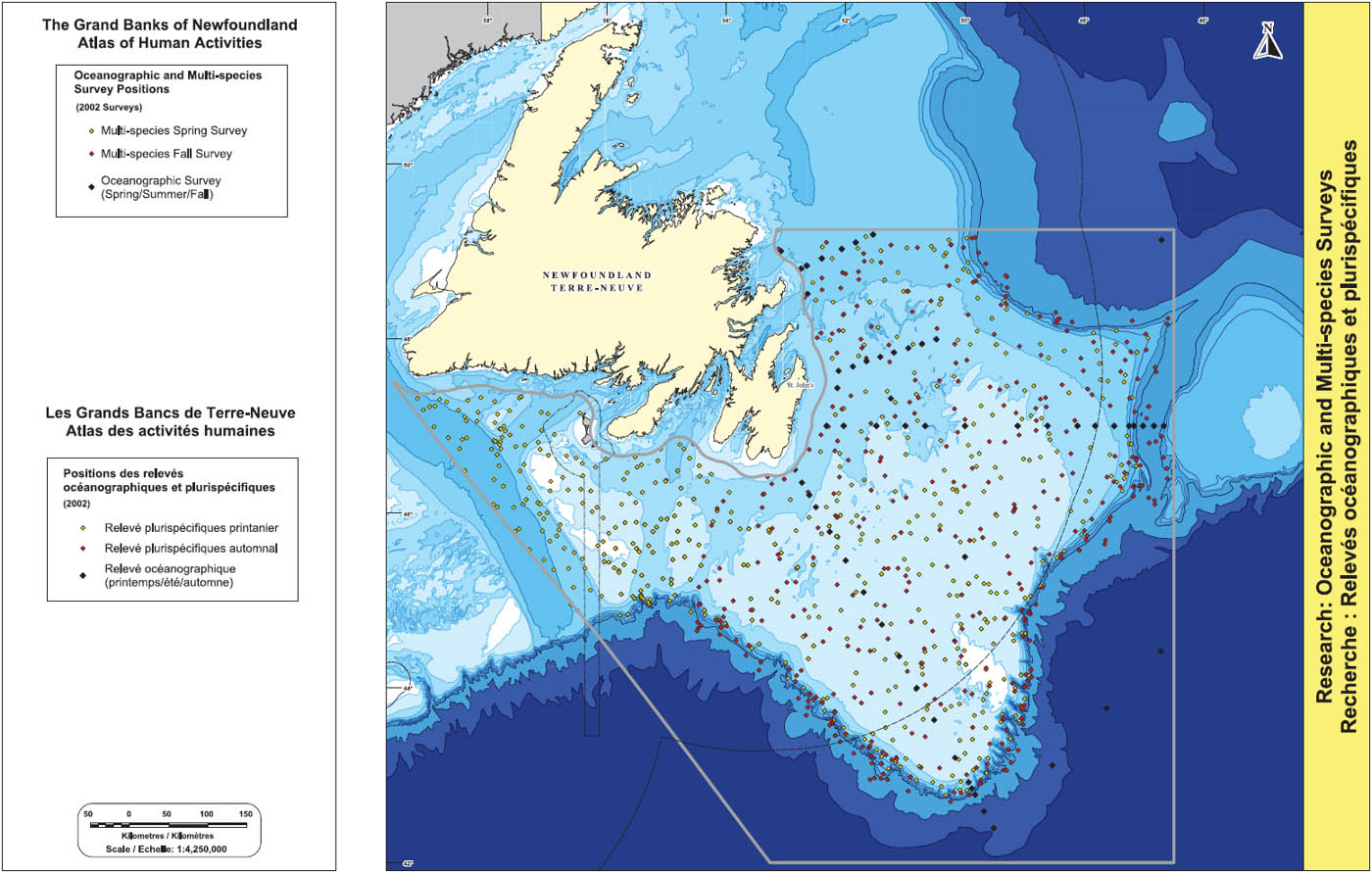
Map depicting research: Oceanographic and Multi-species Surveys
This map depicts oceanographic and multi-species trawl survey locations for a representative year (2002) within the study area. A suite of standard oceanographic monitoring stations along sections of the northwest Atlantic Ocean were adopted in 1976 by the International Commission for the Northwest Atlantic Fisheries (ICNAF) (ICNAF 1978). These monitoring stations extend from Cape Cod (USA) to Egedesminde (West Greenland) and three sections are located within the study area; the Bonavista section (off the Bonavista Peninsula), the Flemish Cap section (crossing the Grand Bank at 47º N continuing eastward to the Flemish Cap) and the Southeast Grand Bank section. Sampling of these sections is incorporated in the Atlantic Zone Monitoring Program (AZMP) through which temperature, salinity, nutrients, oxygen, chlorophyll and plankton are monitored. Annual sampling is conducted two (spring and fall) to three (spring, summer and fall) times per year. In 2002, in addition to the standard sections, the Station 27 section off St. John’s, as well as locations on the Grand Bank and deep water off the southeast Grand Bank were sampled as well.
Fisheries and Oceans Canada has conducted annual stratified random trawl surveys during autumn (fall) in the Newfoundland and Labrador Region since 1977 (Brodie 2005). From 1990 onward the fall survey has covered the offshore areas of Divisions 2J, 3K, and 3LNO and since 1995 have been scheduled to run from late September to mid-December. Brodie (2005) stated “the main objectives are to determine the distribution and abundance of various groundfish and shellfish species and to collect biological samples…the survey design is stratified random, with the allocation of sets proportional to stratum area within a division, and a minimum of two sets in each strata.”
Spring (April – June) random stratified surveys have been carried out on the Grand Bank (3LNO) each year from 1971 to 2004 with the exception of 1983 (Dwyer et al. 2005). Winter-spring random stratified surveys have been conducted by Canada in offshore areas of subdivision 3Ps since 1972 (Brattey et al. 2004). Survey timing has varied over the years with surveys conducted in February, March and April.
Winter, spring and fall surveys have been conducted by research vessels using a variety of sampling equipment. Various trawls (Yankee 36, Engel 145 and Campleon 1800) have been used at different periods of time and conversions exist for comparisons of data between Yankee-Engel and Engel-Campelon sampling (Dwyer et al. 2005).
Brattey, J., N.G. Cadigan, B.P. Healey, G.R. Lilly, E.F. Murphy, P.A. Shelton and J.C. Mahe. Assessment of the cod (Gadus morhua) stock in NAFO Subdivision 3Ps in October 2004. CSAS Research Doc. 2004/083. Canadian Science Advisory Secretariat.
Brodie, W.B. 2005. A Description of the Autumn Multispecies Surveys in SA2 + Divisions 3KLMNO from 1995-2004. NAFO SCR Doc. 05/8. Serial No. N5083. Northwest Atlantic Fisheries Organization.
Dwyer, K.S., M.J. Morgan, D. Maddock-Parsons, W.B. Brodie, B.P. Healey, P.A. Shelton and H. Murua. 2005. An Assessment of American Plaice in NAFO Divisions 3LNO. NAFO SCR Doc. 05/61. Serial No. N5147. Northwest Atlantic Fisheries Organization.
ICNAF. 1978. List of ICNAF Standard Oceanographic Sections and Stations. ICNAF selected papers #3. International Commission for the Northwest Atlantic Fisheries.
Submarine CablesFootnote 4

Map depicting Submarine Cables
The submarine cable data depicted on this map is derived from the Atlantic Submarine Cable and Pipeline Database that has been compiled by the Canadian Hydrographic Service (CHS) in conjunction with International Telecom. The positions have been compiled from archival CHS records as well as information provided by cable companies (CHS 2005). Additional information was accessed through Notices to Mariners (DFO 2005) and the International Submarine Cable Protection Committee (ISCPC 2005). It is recognized that some cables are depicted as having end points in the open ocean. This is how that data is presented on CHS (2005) and may reflect incomplete data.
The study area contains several abandoned submarine cables many of which date back to the days of telegraph communications (19th century). The majority of these cables are located in the northern and western portions of the study area. Currently, the only active submarine cables in the area are found in deep water off the south and southeast portion of the Grand Bank. Hibernia Atlantic operates a modern fiber-optic cable that runs from the UK and Ireland to the United States, and Teleglobe Canada operates a cable that runs from Pennant Point, Nova Scotia to Iceland (pers. comm. Andrew Smith, Canadian Hydrographic Service).
DFO. 2005. Notice to Mariners website. Fisheries and Oceans Canada. Date accessed September 14, 2005.
CHS. 2005. Canadian Hydrographic Service. Fisheries and Oceans Canada. Date accessed September 14, 2005.
ISCPC. 2005. International Submarine Cable Committee.
Smith, Andrew. MD Hydrographer. Canadian Hydrographic Service. Dartmouth Nova Scotia.
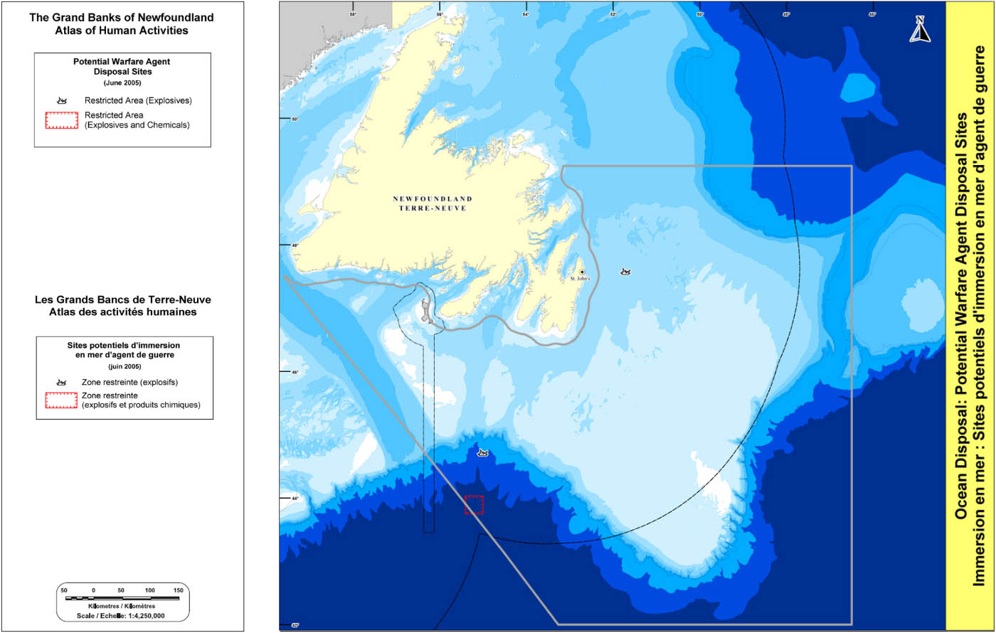
Ocean Disposal: Potential Warfare Agent Disposal Sites
The Warfare Agent Disposal (WAD) project was initiated by the Department of National Defence (DND) in the early 1990s to address the ocean dumping and burial of weapons and chemicals that occurred after the Second World War (DND 2005). DND (2005) stated “the main objective of the WAD project is to identify and assess all warfare agent disposal sites across Canada and in Canadian waters and to prioritize these sites according to the risks they may pose to human health and the environment.”
This map depicts the location of warfare agent disposal sites within the study area based on navigational charts and Notices to Mariners (CHS 1999a; 1999b, DFO 2004). There are two known disposal sites for explosives in the study area; one due east of St. John’s and the other on the slope area south of Whale Bank. Please note the symbol for the more northerly site does not depict the exclusion area because it is too small to display at this scale. Another site, in deep water due south of the Halibut Channel, contains both explosives and chemicals.
CHS. 1999a. Navigational Chart 4047: St. Pierre Bank to Whale Bank. 1:400,000. Canadian Hydrographic Service.
CHS. 1999b. Navigational Chart 4049: Grand Bank Northern Portion to Flemish Pass. 1:400,000. Canadian Hydrographic Service.
DFO. 2004. Notice to Mariners June 25, 2004. Fisheries and Oceans Canada.
DND. 2005. Backgrounder: Warfare Agent Disposal Project. Department of National Defence . Date accessed September 21, 2005.
Map depicting the Ocean Disposal: Potential Warfare Agent Disposal
- Date modified: