
Sovereignty and UNCLOS
Defining Canada’s Extended Continental Shelf
Fisheries and Oceans Canadian Hydrographic Service, Natural Resources Canada’s Geological Survey of Canada and Global Affairs Canada, with the support of the Canadian Coast Guard and other international partners, have worked for several years on a project to determine the outer limits of Canada’s extended continental shelf, under the United Nations Convention on the Law of the Sea (UNCLOS).
UNCLOS is an international treaty that sets out the legal framework for ocean activities. It defines the maritime zones along a country’s coastline, and the rights and duties of a country regarding these zones. UNCLOS also recognizes that coastal states have sovereign rights over the natural resources of the seabed and subsoil of the continental shelf, as well as jurisdiction over certain activities like marine scientific research.
It states that countries can extend their territory beyond 200 nautical miles if they can show that their continental shelf is a natural prolongation, or continuation, of its land territory. The continental shelf beyond 200 nautical miles is known as “the extended continental shelf.” An estimated 85 countries, including Canada, are thought to have an extended continental shelf.
In 2003, Canada embarked on a history-making project to define the outer limits of its continental shelf in the Atlantic and Arctic Oceans. In 2013, Canada filed a submission to the United Nations regarding its continental shelf in the Atlantic Ocean and preliminary information concerning the outer limits of its continental shelf in the Arctic Ocean.
Canada is continuing to collect and analyze continental shelf data in the Arctic Ocean and is collaborating with neighbouring states in the scientific, technical and legal work needed to do so.
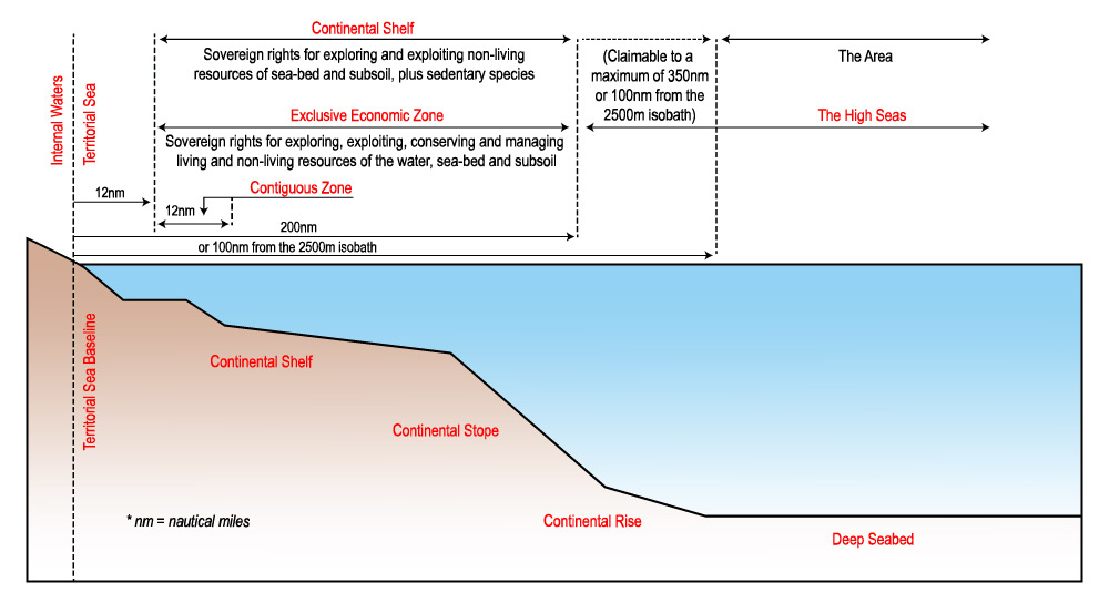
Maritime sovereign rights, by zones, under the Law of the Sea Treaty
Click thumbnail to enlarge
Video: The Science of UNCLOS
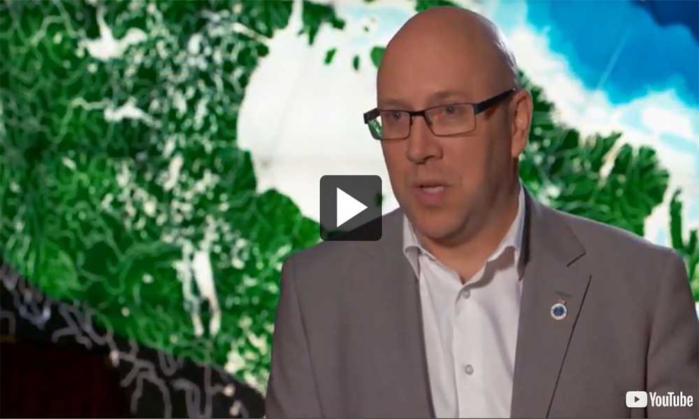
Video: Chris Hemingway, Director of Hydrography and the Law of the Sea Program
-
The Atlantic Submission on Canada’s Extended Continental Shelf
The Atlantic Submission on Canada’s Extended Continental Shelf

In the Atlantic submission, the area was divided into three regions–the Labrador Sea, Grand Banks and Nova Scotia.
Click thumbnail to enlarge
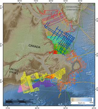
Snapshot of surveys done over 40 years that were used in the Atlantic partial submission. Each colour represents a different survey. Surveys with more widely spaced lines used a single beam echosounder and indicate the wealth of legacy data used in the submission. UNCLOS-specific surveys used a multibeam echosounder, with superior bottom coverage that is shown by the solid and near-solid colours.
Click thumbnail to enlarge
The Government of Canada filed a submission on the outer limits of its continental shelf in the Atlantic Ocean with the Commission on the Limits of the Continental Shelf on December 6, 2013.
This submission fulfilled Canada’s obligation to provide information about the limits of its extended continental shelf within 10 years of becoming a party to the United Nations Convention on the Law of the Sea (UNCLOS). However, it was a partial submission. Canada is now preparing the other part of its submission, which will define the Show the first panel outer limits of its extended continental shelf in the Arctic Ocean.
A multi-faceted effort
Scientists at the Canadian Hydrographic Service and the Geological Survey of Canada were responsible for acquiring, processing and interpreting data, as well as preparing the technical and scientific details of the submission. The legal and diplomatic aspects of the submission were handled by Foreign Affairs, Trade and Development Canada.
The area under examination in the Atlantic submission lies 200 nautical miles beyond the baseline of Canada’s territorial sea in the Atlantic. Its 1.2 million square kilometres of sea floor extend from Nova Scotia in the south, along the Grand Banks to the northern tip of Labrador. In the submission, this area was divided into three regions–the Labrador Sea, Grand Banks and Nova Scotia–to address each region’s unique characteristics.
Collecting Data for the Atlantic Submission
The science used to determine the outer limits of the extended continental shelf is complex and the techniques are time-consuming. Article 76 of UNCLOS describes the required scientific process. Canadian scientists collected 13,000 kilometres of seismic data and over 18,000 kilometres of bathymetric data during the project. These data were used to determine the origins, age, structure, depth and composition of the seabed in all three regions.
UNCLOS-specific expeditions in the Atlantic
The Canadian Hydrographic Service conducted four survey expeditions specifically geared to the Atlantic portion of Canada’s submission regarding its extended continental shelf. The surveys included:
- multibeam bathymetric survey around the Grand Banks was completed in 2006
- bathymetric survey off the Scotian Shelf was completed in 2007
- multibeam survey was completed in the Labrador Sea in 2009
- multibeam and sub-bottom surveys were completed off the Scotian Shelf in 2012
Legacy data
The Atlantic portion of the UNCLOS submission had a head start because Canada’s offshore waters in the Atlantic have been well surveyed. To supplement the collection of mission-specific data, hydrographers made use of “legacy” bathymetric data. Such data was acquired in Canadian Hydrographic Service surveys dating back to 1974. Hydrographers also made use of data that had already been collected by other organizations for other, older projects. Most of the legacy data was obtained using single beam sonar equipment.
-
Canada’s Extended Continental Shelf in the Arctic Ocean
Canada’s Extended Continental Shelf in the Arctic Ocean
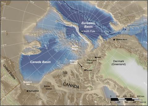
Topographic map showing the geographic features for Canada’s surveys of its extended continental shelf in the Arctic: the Canada Basin, the Lomonosov Ridge, the Alpha Ridge, Ellesmere Island and Greenland.
Click thumbnail to enlarge
The Arctic Ocean: A True Frontier
The Arctic Ocean is the world’s smallest ocean, with an approximate area of 9.5 million square kilometres. Almost half of this ocean region consists of continental shelf areas and much of these are less than 200 metres deep.
Much of the Arctic is covered in ice most of the year and accessible only during a few summer months. The area of interest for survey teams lies well north of the Northwest Passage, and involves a lengthy voyage in harsh environmental conditions, a long way from support networks.
Work in the Arctic
The area under examination for Canada’s submission regarding its extended continental shelf in the Arctic Ocean begins 200 nautical miles offshore from Canada’s Arctic coastlines and covers roughly 750,000 square kilometres. The region extends from the Canada Basin to the Lomonosov Ridge north of Ellesmere Island and Greenland, and beyond the North Pole.
Breaking the Ice in 2006
The first survey expedition to the Arctic as part of Canada’s Extended Continental Shelf Program was conducted in the winter of 2006. This expedition, and others that followed, involved pain-staking preparations and arduous research to respond to challenges, such as the Arctic’s harsh and unpredictable weather, its shifting ocean ice, the need for costly specialized equipment, the vagaries of transportation to and in the Arctic, and the shortage of previous scientific research. The expeditions have included both ship-board and ice camp survey programs. Some of the expeditions have been joint efforts with other Arctic nations or with other scientific groups within Canada.
Survey expeditions in 2006, 2007 and 2008 determined the continuity of Canada’s Arctic mainland with the Lomonosov Ridge and Alpha Ridge. An on-ice expedition in March 2006 established that the Arctic ridges were a natural prolongation, or continuation, of Canada’s land mass.
Survey teams also acquired bathymetric and seismic data to determine the location of the 2,500-metre isobaths (depth contours), and morphological and geological evidence of the foot of the slope.
Survey Expeditions to the Arctic Ocean
Eastern Arctic
- An on-ice expedition, called LORITA (Lomonosov Ridge Test of Appurtenance), was carried out on the Lomonosov Ridge by Canada and Denmark in the winter of 2006. A refraction seismic survey and bathymetry spot soundings were conducted from Canadian Forces Station (CFS) Alert
- Canadian-Danish seismic and bathymetric surveys aboard the IB/RV Oden collected data on Lomonosov Ridge in the summer of 2007
- A refraction seismic survey of the Alpha Ridge, called ARTA (Alpha Ridge Test of Appurtenance), was carried out from the community of Eureka on Ellesmere Island, as well as a through-ice bathymetric survey from an ice camp at the mouth of Nansen Sound in the winter of 2008
- A Canadian-Danish through-ice sounding program in the winter of 2009 used helicopters from an ice camp located on the Ward Hunt ice shelf
- A Canadian-Danish aero-gravity and aero-magnetic program between Ellesmere Island and the North Pole, was flown from Eureka, CFS Alert and Station Nord in the winter of 2009
- Bathymetry surveys and gravity readings were conducted from Borden Island in 2010
- Bathymetric and seismic surveys were conducted from the Canadian Coast Guard icebreaker CCGS Louis S. St-Laurent while the CCGS Terry Fox broke ice in 2014. Bathymetry data were collected in Amundsen Basin and Canada Basin
Western Arctic
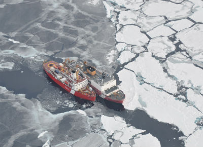
CCGS Louis S. St-Laurent conducts seismic surveys following USCGC Healy icebreaker.
- Project Cornerstone began in 2008 with the goal of developing the equipment and methodology necessary to collect high-resolution, hydrographic-quality, bathymetric data of the Arctic seabed in harsh weather conditions. In this joint CHS-NRCan project, autonomous underwater vehicles (AUVs) were used to collect bathymetry data to augment previously collected spot soundings and seismic, gravity and magnetic information. After AUV trials on the West Coast, the first Arctic mission was carried out in April 2010. The second mission was conducted in 2011 after further testing in the St. Lawrence River
- Bathymetric and test seismic surveys were conducted in the Canada Basin from the CCGS Louis S. St-Laurent in 2006 and 2007
- In a joint project with the United States, bathymetric and seismic surveys of the Canada Basin were conducted in 2008, 2009, 2010 and 2011 from the 2 giant icebreakers, the CCGS Louis S. St-Laurent and the U.S. Coast Guard cutter Healy
- Science writer Hans Böggild described the 2011 joint Canada–US survey using the U.S. Coast Guard cutter Healy and the CCGS Louis S. St-Laurent. The technology and techniques of the Canada-U.S. mission are described in several papers presented at the 2010 Canadian Hydrographic Association Conference. An article on the United States Geological Survey website also describes technology used on the U.S.’s Healy and the CCGS Louis S. St-Laurent
- CHS surveying efforts in the Arctic, spanning 1998 to 2010, are described in a series of newsletters, written by Ronald Verrall, with support from Defence Research and Development, Canada (DRDC) in Halifax
Challenges
Several factors complicate scientific work for Canada’s extended continental shelf in the Arctic Ocean. The Arctic’s extremely cold and unpredictable weather, the extent of the ocean’s ice coverage, the depth of the ocean itself, inaccessibility to certain areas and shifting ice pose difficulties for ship navigation and scheduling of surveys, as well as safety hazards.
The cost of mounting an expedition to the Arctic poses further difficulties. Two icebreakers are required for a survey expedition into the High Arctic. They move slowly and follow a designated route depending on weather and areas of operation, as well as the services required by multiple government and commercial partners on board. But even with designated routes, adjustments need to be made on the spot when ice thickness and weather-related hazards interfere with the course of the icebreakers.
-
Acquiring Data for Canada’s Extended Continental Shelf Program
Acquiring Data for Canada’s Extended Continental Shelf Program
Hydrographers have used a variety of data acquisition techniques to conduct bathymetric surveys over the years. To meet UNCLOS requirements, Canadian survey teams have tested and worked with the latest technological innovations, including deep-water multibeam echosounders and autonomous underwater vehicles, as well as the most efficient and accurate methodologies in ship-board survey operations and ice camps). Scientific teams have also engaged in national and international collaboration to pool their expertise, knowledge, equipment and other resources.
To acquire data about Canada’s continental shelf in the Atlantic region, hydrographers conducted four bathymetric surveys between 2006 and 2012. They also acquired data from historical surveys that used earlier data acquisition technologies, such as single beam echosounders, as well as previously collected data from international sources.
Survey data of the Arctic region, however, was sparse and outdated at the launch of Canada’s Extended Continental Shelf Program in 2003. On UNCLOS-specific survey expeditions in the High Arctic, hydrographers have faced several challenges, including harsh, unpredictable weather, extensive ice coverage and the extreme depth of the ocean. In response, they have tested and developed methodologies and technologies for the best survey results.
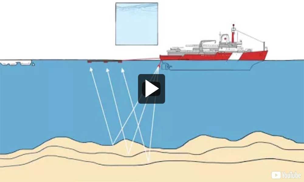
Deep-Water Multibeam Echosounder
The state-of-the-art tool for depth-sounding acquisition is the multibeam echosounder (MBES), which collects data in a wide swath along a survey line. An MBES transmits and receives hundreds of beams of sound through the water column to capture depth points that, when gridded, produce detailed, high-resolution images of the seabed. This technology allows hydrographers to see nearly 100 percent of the seabed in a three-dimensional representation.
From 2007 to 2011, Canadian scientists teamed with U.S. counterparts for four joint surveys in the Arctic. The Canadian Coast Guard icebreaker CCGS Louis S. St-Laurent was paired with the U.S. Coast Guard’s Healy. Equipped with a deep-water MBES, the Healy icebreaker was capable of surveying to full ocean depths. It was first equipped with a SeaBeam 2112 system and later converted to the Kongsberg EM122. During these joint expeditions, the CCGS Louis S. St-Laurent broke ice for the Healy when the MBES was collecting data, and then the ships changed position for the CCGS Louis S. St-Laurent to collect seismic data.
In summer 2014, a survey expedition to the Arctic was conducted on two of Canada’s biggest icebreakers, the CCGS Louis S. St-Laurent and the CCGS Terry Fox. For this mission, Canada acquired its own deep-water MBES, a Kongsberg EM122. The MBES was installed on the CCGS Louis S. St-Laurent in the spring of 2014.
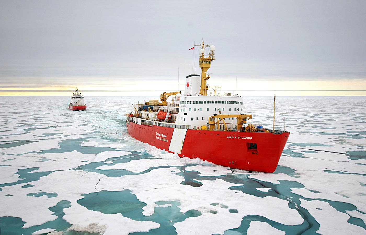
CCGS Louis S. St-Laurent and CCGS Terry Fox supported Canada’s UNCLOS mission during 2015 (G Williams, CCG)
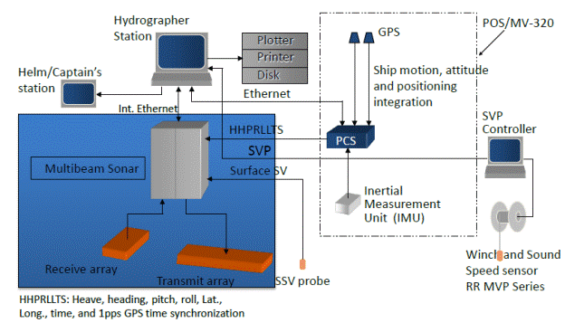
Schematic illustrating the associated equipment used on a ship with the MBES to collect and clean data.
Schematic illustrating the associated equipment used on a ship with the MBES to collect and clean data.
Cleaning Data
The data initially collected by a deep-water MBES is raw. Hydrographers go through several steps to "clean" the data, that is, they process the data by measuring and compensating for factors that affect the speed of sound beams through water. These factors include salinity and temperature of water (which affect water density) and location, or position, of the sound beam, as well as the motion of the ship.
The hydrographic survey team also uses expendable XCDT probes to measure the conductivity, temperature and depth of water, producing sound velocity profiles. These sound velocity profiles allow the MBES system to make adjustments to transmit and receive data accordingly.
The big challenge in the High Arctic is that an icebreaker, such as the CCGS Louis S. St-Laurent, moves through very thick ice, which scrapes and hits the metal hull. The MBES picks up the sounds of breaking ice, which produce "noise" in the sound depth reading.
Once all data are cleaned, the millions of depth data points are gridded to render a 3D image of the ocean bottom. Then, hydrographers move to the next stage of the process–interpreting the data for application to UNCLOS article 76 requirements.
Autonomous Underwater Vehicles
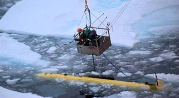
An autonomous underwater vehicle is recovered from the Arctic depths by a mechanical lift on the CCGS Louis S. St-Laurent icebreaker during the 2011 Arctic survey expedition.

Hydrographer George Schlagintweit, Canadian Hydrographic Service, DFO, takes gravity measurements over the Lomonosov Ridge using a portable gravity meter placed on the ice. Also on the ice (connected by yellow cable to a recording device inside the helicopter) is an echo sounder transducer used to measure ocean depth.
Photo credit: Janice Lang, NRCan, CHS/DFO
During survey trips for Canada’s Extended Continental Shelf Program to the Arctic, Canadian scientists have also used autonomous underwater vehicles (AUVs). In the joint Canada-U.S. expedition in 2011, the CCGS Louis S. St-Laurent deployed an AUV at the Sever Spur area of the Arctic Basin. The AUV travelled approximately 100 metres above the ocean floor to collect data.
Ice Camps
Ice camp surveys are invaluable for areas in the Arctic that are inaccessible to ships, even if they face their own challenges related to shifting ice and unpredictable weather. Canadian scientists have used ice camps on four occasions in Canada’s Arctic to perform bathymetric surveys for Canada’s Extended Continental Shelf Program:
- the joint Canada-Denmark survey called LORITA (Lomonosov Ridge Test of Appurtenance, in 2006
- the Canadian survey called ARTA (Alpha Ridge Test of Appurtenance), in 2008
- the Joint Canada-Denmark survey from Ward Hunt Island, NU, in 2009
- the Canadian survey from Borden Island in 2010
Setting up in early spring
Ice camp surveys must be conducted in the early spring before the ice breaks up and foggy conditions prohibit aircraft support. The ice camp, including runways for aircraft, must be constructed before survey work can begin. After the survey is completed, the ice camp must be totally dismantled. While airplanes are used to fly team members and supplies into the camp site, Bell helicopters are more agile for transporting team members along the survey route.
CHS team members used echosounder transducers and gravity meters (or gravimeters) for the on-ice survey. They also recorded the sounding site positions with GPS.
An echosounder transducer sends a sound wave through the ice into the water. The sound wave then echoes off the bottom of the ocean and returns through the ice to the transducer. At each interface (air to ice, ice to water, water to ice, or ice to air), some sound is reflected and lost. This effect is greatest where the air meets the ice surface. The loss of sound can be minimized by bonding the transducer to the ice with a thin layer of vegetable oil.
-
Hydrography for Canada’s Extended Continental Shelf Program
Hydrography for Canada’s Extended Continental Shelf Program
Video: Paola Travaglini, Chief Hydrographer on Canada’s UNCLOS mission
The Canadian Hydrographic Service and the Geological Survey of Canada are responsible for delivering the scientific portion of Canada’s Extended Continental Shelf Program. Their work involves conducting bathymetric and seismic surveys of Canada’s offshore seabed in the Atlantic and Arctic oceans.
These surveys provide scientists with information about the depth, distance, shape and composition of the seabed as well as the thickness of its sediment. These data are used to determine the outer limits of Canada’s extended continental shelf, as well as its maritime zones.
Continental Margin
The continental margin is the natural underwater prolongation, or continuation, of a country’s land mass offshore before it reaches the deep ocean floor. The geological definition of the continental margin consists of the continental shelf, the continental slope and the continental rise.
According to article 76, a country with a narrow continental margin will determine its continental shelf to be 200 nautical miles from the baselines of its territorial sea. But a country with a wide continental margin can delineate this extended continental shelf to the outer limits of its continental margin. This extended continental shelf differs from the geological definition mentioned above because it is a juridical (or legal) definition, and depends on formulas and constraints based on scientific proof.
Applying the Formulas and Constraints of Article 76
Scientists must apply a combination of mathematical formulas and constraints, outlined in article 76 of UNCLOS, to establish geographic coordinates in latitude and longitude, or fixed points. These fixed points are used to define the outer limits of the extended continental shelf.
The two formulas
UNCLOS’s article 76 outlines the two formulas for justifying an extended continental shelf:
- measure 60 nautical miles from the foot of the continental slope (FOS)
- determine where the sediment thickness of the subsoil is at least 1% of the distance to the foot of the slope (i.e., vertical thickness ÷ distance from FOS ≥ 1%)
Countries can use the most seaward points from the union of these two lines, providing they do not exceed the limits of the constraints related to the foot of the continental slope.
The Foot of the Continental Slope
The first step in determining an extended continental shelf, as described in article 76 of UNCLOS, is to determine the foot of the continental slope. The continental slope is where the continental shelf plunges at the steepest gradient down to the ocean floor. The foot of the slope is at the lowest point of the slope. Hydrographers from the Canadian Hydrographic Service conduct detailed deep-water bathymetric mapping to measure and calculate the maximum gradient of the slope.
The two constraints
Article 76 of UNCLOS sets out two constraints for calculating the maximum distance for the outer limits of a country’s extended continental shelf. The outer limits can go no further than the most advantageous option of these two constraints:
- 350 nautical miles from the baselines of the territorial sea
- 100 nautical miles from the 2,500-metre isobath
- An isobath is a line on a map or chart that connects all points having the same underwater depth. The 2,500-metre isobath, therefore, is a line along the seabed that connects all points having a water depth of 2,500 metres. This deep contour is determined by interposing the depths obtained by hydrographers using both single beam and multibeam sonar
Scientific Work for Canada’s Extended Continental Shelf Program
The main activities of Canadian Hydrographic Service (CHS) for the Extended Continental Shelf Program include:
- reviewing the baselines from which the breadth of the territorial sea is measured—here new coastline and low-water line data are available, work may involve mapping new baselines with the use of remote sensing and satellite imagery analysis
- mapping the foot of the continental slope along the seabed
- mapping the 2,500-metre isobath, or depth contour, of the continental slope or isolated submarine elevations
- deciding on the case for “evidence to the contrary,” that is, when other geophysical types of data might be gathered and used in surveys in addition to bathymetric data to define a more advantageous foot of the slope
- creating arcs of lines at calculated geodetic distances, as defined by article 76, such as 60 nautical miles from the foot of the continental slope, 100 nautical miles from the 2,500-metre isobath, 200 nautical miles from the baseline of the territorial sea and 350 nautical miles from the baseline of the territorial sea
- preparing databases for the above information
- preparing output in the form of tables, charts, maps and diagrams to support Canada’s submission to the Commission on the Limits of the Continental Shelf
- describing the scientific methods, technology and data justifying the extension of the continental shelf
CHS surveys in the Arctic and the Atlantic have enhanced the understanding of marine areas that had previously been under-surveyed, as well as increased the number of scientific publications on the subject, and promoted international scientific cooperation and improved charting.
International Scientific Cooperation
Defining Canada’s extended continental shelf has involved Canadian scientists in international collaboration with their counterparts in the United States and Denmark.
For the Atlantic submission, Canadian scientists worked with Denmark in the Labrador Sea and with the United States off the Scotian shelf. In the Arctic Ocean, Canadian scientists collaborated in joint surveys with Denmark and the United States.
The Canadian Hydrographic Service also contributes the bathymetric data it has collected as part of Canada’s Extended Continental Shelf Program to the International Bathymetric Chart of the Arctic Ocean.
-
Survey Teams for Canada’s Extended Continental Shelf Program
Survey Teams for Canada’s Extended Continental Shelf Program
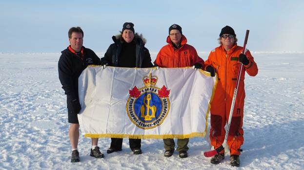
Hydrographic Survey team members (left to right, Hydrographer Jim Weedon, Hydrographer-in-Charge Paola Travaglini, Hydrographer Chris LeBlanc and Electronics Technician Dave Levy) raise the CHS flag at the North Pole during the 2014 Arctic expedition aboard CCGS Louis S. St-Laurent icebreaker.
Photo credit: W.Rainey
Survey teams of the Canadian Hydrographic Service (CHS) collect the bathymetric data required to determine the outer limits of Canada’s extended continental shelf, as outlined by article 76 of UNCLOS.
For Canada’s Extended Continental Shelf Program, CHS survey teams have used multibeam echosounders to collect data on ship-board expeditions in the Atlantic and Arctic oceans. In ice-covered areas of the Arctic that are inaccessible to ships, survey teams have been flown in to conduct surveys from ice camps.
Arctic expeditions can involve hydrographers spending six weeks or more collecting data for the maximum coverage of survey lines that conditions allow. Unpredictable weather and ice coverage can hamper and delay data acquisition. But the survey team must work to achieve the highest quality of data within a gap-free survey line while dealing with the constraints of their surroundings and technology, as well as ensuring the safety of personnel and equipment.
- Date modified: