
Hydrography data management
Learn about hydrography data management and the Hydrographic Information Network.
On this page
About hydrography data management
The Canadian Hydrographic Service (CHS) works with computer software manufacturers and the international hydrographic community to introduce and refine the latest technology for the production of nautical charts and navigational products and services.
To produce nautical charts, the CHS conducts hydrographic surveys. These capture data in various formats, including information about:
- tides
- currents
- water levels
- water depths
- hazards to navigation
- geographical features
- sea bottom characteristics
- human-made and natural features that aid navigation
Once we get the data, we need to process, manage, transform and store it. We call this integrated science data management.
The resulting products and services must also be organized and managed for distribution.
Hydrographic Information Network
The Hydrographic Information Network is the basic database network for the management of hydrographic data at CHS. It's a series of systems used to create and deliver most of our services and products.
The network is based on CHS' fundamental functions, which are data:
- gathering
- management
- transformation
- sharing
The network design has been developed over the past 25 years to incorporate new technologies as they become available. Each new component is designed to:
- minimize:
- duplication of data
- the number of systems needed
- meet a maximum of requirements
Canadian Hydrographic Service Directory
The CHS directory is a meta-database of the Hydrographic Information Network. It:
- is used to store information about:
- products
- documents
- source data
- has functions and tools for planning and production
- includes other information, such as:
- chart formats
- other planning documents
The stored metadata includes:
- maps, charts and textual documents
- information about the digital data collected in hydrographic surveys, such as:
- extent
- quality
- distribution
- identification
- spatial reference
- spatial and temporal schema
Bathy Database
Source bathymetric data are data as close as possible to their collection stage which we've processed to correct systematic and human errors.
CHS introduced the Bathy Database in 2011. It normalizes and integrates all of our bathymetric data sources into a single system.
These data sources include:
- legacy data digitized from historical field sheets which:
- were collected by CHS or the British Admiralty
- used lead line and single-beam echosounder techniques
- are from the end of the 19th century to the end of the 1980s
- recent survey data, which are:
- used to produce field sheets
- converted directly from original field data format into some uniform storage
Data sources are of all ages from external organizations for different purposes, including:
- dredging
- engineering
- coastal management
This data is transmitted in different formats and provided to CHS through agreements with:
- academia
- private-sector partners
- other government departments
Data comes from special types of sounding methods, such as:
- lidar
- spot echosounding
- through-the-ice bathymetric system
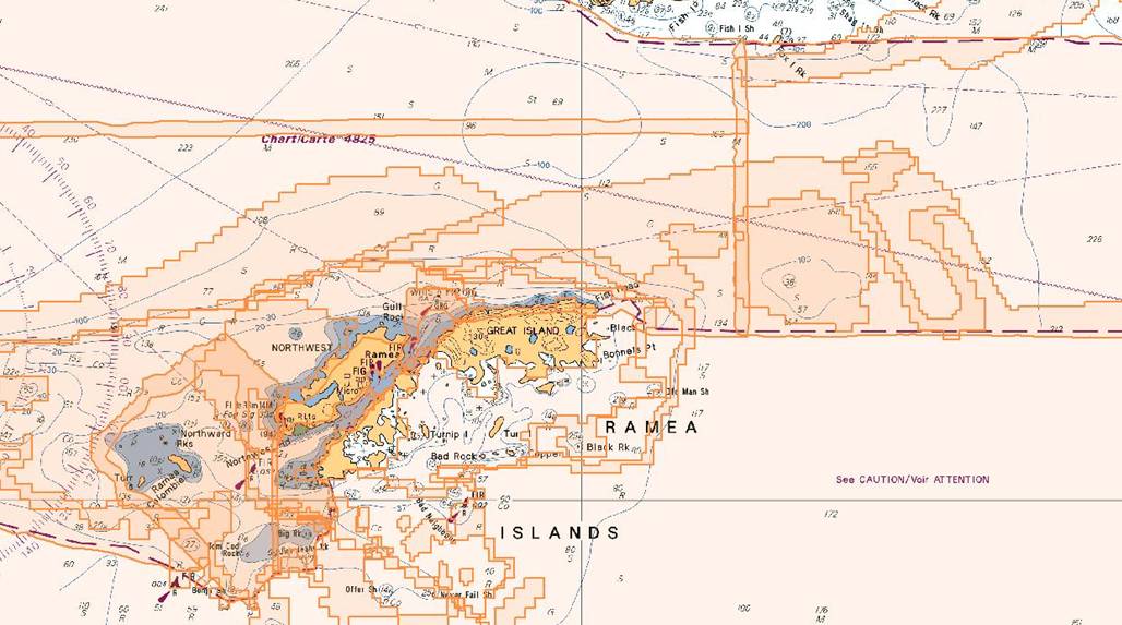
Example of initial Bathy Database view of nautical chart 4826. Covers Ramea Islands, Newfoundland.

An example of the Bathy Database, after the bathymetric data sources have been loaded into nautical chart 4826. Covers Ramea Islands, Newfoundland.
The Bathy Database also stores 2 categories of data:
- navigational surface, which:
- represents the bathymetry on a regular grid
- is usually acquired by total coverage echo sounding systems
- sparse, spatially discrete soundings acquired by other depth measurement systems
These 2 categories of source datasets are loaded in as surfaces or sounding sets (point clouds).
The database can also manage backscatter supplied by multibeam echosounders.
Because of the volume and variety of the source data, the initial loading of any data is a considerable undertaking. All data must be converted into a known data format and adjusted to a common vertical datum (the chart datum). The data are then compared to existing, overlapping datasets and the data most closely representing the seabed are selected for use.
Hydrographic production database

Diagram of the hydrographic production database.
The hydrographic production database offers an integrated suite of products that manage all data in a single database. This allows simultaneous data processing and workflow by multiple users.
Data storage is efficient because there's no duplication and the data can be used for different products.
For the first time, electronic and paper charts can be made almost at the same time. They can be produced using the same data, which ensures greater:
- consistency between the 2 versions
- efficiency and shorter time frames for production
Updates can be done and the status of updates can be tracked from source to product. The history of all changes is recorded.
ChartServer
ChartServer is primarily concerned with managing data for digital charts that have already been released.
It assembles the base data so that they can be included and maintained in various chart collections to be updated as needed.
ChartServer also generates updated packages so that clients can keep their CHS charts up to date. The updates are distributed from a password-protected website.
Metadata from ChartServer are also used for charts on other websites.
Related links
- Date modified: