
Canadian Council of Fisheries and Aquaculture Ministers (CCFAM)
Report on Canada’s Network of Marine Protected Areas
December 2018
Table of Contents
- Complete Text
- List of Acronyms
- Executive Summary
- Introduction
- Part A: Implementing the National Framework for Canada’s Network of MPAs
- Part B: Thematic Focus of the Report – Role of Socio-Economic and Cultural Analysis in MPA Network Development and MPA Establishment
- Conclusion
- Glossary
- Annex: Summary of Global Research on MPA Network Effectiveness
- Figure 1: Conserved Area of Canada’s Marine and Coastal Waters
- Figure 2: MPA Network Development Process
- Figure 3: Socio-Economic Analysis in Network Design and MPA Establishment
- Figure 4: The Network Development Process
- Figure 5: Process to Establish Oceans Act MPAs
- Box 1: Defining MPAs, MPA Establishment, and MPA Network Development
- Box 2: Five-Point Plan for Achieving Marine Conservation Targets
- Box 3: Defining Socio-Economic Analysis for Establishing Oceans Act MPAs
- Box 4: Examples of Possible MPA Network Conservation Measures
- Box 5: Types of Economic Data and Information Sources used for MPA Network Planning and MPA Establishment
- Box 6: Consultation and Engagement Activities during the Selection and Establishment of the St. Anns Bank MPA
- Box 7: How Decision-Support Software Works
- Box 8: Network Planning in the Western Arctic Bioregion
- Box 9: Balancing Conservation Objectives and Socio-Economic and Cultural Impacts
- Box 10: Establishing National Marine Conservation Areas
- Box 11: Example of Socio-Economic Analysis for Anguniaqvia niqiqyuam MPA
- Box 12: Laying the Groundwork for Marine Spatial Planning in British Columbia
- Box 13: Example of the Integration of Social, Cultural and Economic Information – Tallurutiup Imanga National Marine Conservation Area
Part B: Thematic Focus of the 2018 Report – Role of Socio-Economic and Cultural Analysis in MPA Network Development and MPA Establishment
This report focuses on how socio-economic data and cultural information are collected and integrated into MPA network development and provides examples illustrating how this information is used in Oceans Act MPA establishment (see Box 6). Socio-economic data are readily available from various government sources (see Box 5). Cultural values, which usually arise from the lived realities of local residents, are more challenging to define and more difficult to incorporate into decision making. These considerations include spiritual places sacred to generations of Indigenous Peoples, as well as those values placed by individuals or groups on recreational areas, and the historical importance of heritage shipwrecks.
The National Framework notes that while the main objective of Canada’s national network of MPAs is long-term protection of marine biodiversity, ecosystem function, and special natural features, there are many sites that are socially and culturally important to local Indigenous and non-Indigenous communities as well as to Canadians generally.Footnote 10
While socio-economic analysis lends itself to quantitative analysis and the methodologies to assess the economic impacts (such as the CBA during MPA establishment) are well developed, recognition of social and cultural values often requires a more qualitative approach. Nonetheless, it is possible, using a combination of quantitative and qualitative tools, to accommodate conservation, human use, and cultural considerations within an MPA network design and in MPA establishment.
Box 3: Defining Socio-Economic Analysis for Establishing Oceans Act MPAs
In the context of MPA network design and MPA establishment processes, the scope of socio-economic analysis is guided by the Treasury Board of Canada Secretariat’s (TBS) definition of terms in the Canadian Cost-Benefit Analysis Guide: Regulatory Proposals. According to this Guide, “economic” refers to “… benefits and costs that will affect economic welfare and economic growth,” and “social” refers to “… the potential distributional impacts of policies being evaluated.”
When creating an MPA network design, socio-economic data are used in combination with other information, such as ecological and cultural, to identify the total economic value of activities in the geographic areas under consideration for the MPA network.
The designation of an area as an Oceans Act MPA requires a cost-benefit analysis (CBA) to assess the incremental impacts of the management measures (i.e., prohibitions and allowed activities) specified in the MPA regulations on the Canadian economy and society at both national and regional levels.
Box 4: Examples of Possible MPA Network Conservation Measures
- Marine Protected Areas (including Oceans Act MPAs, National Marine Conservation Areas, marine National Wildlife Areas, and marine portions of Migratory Bird Sanctuaries, National Parks and Provincial or Territorial protected areas).
- Other Effective Area-Based Conservation Measures, including marine refuges (some fisheries area closures), and other areas that meet science-based criteria set out in DFO’s Operational Guidance Identifying ‘Other Effective Area-Based Conservation Measures’ in Canada’s Marine Environment.
- Tribal Parks, also referred to as Tribal Protected Areas, they are Indigenous-led and while mainly used in a terrestrial context, they may provide coastal biodiversity conservation benefits.
- Indigenous and Community Conserved Area (ICCA) is an internationally recognized term for conserved areas that are led by Indigenous groups and other communities.
Source: Economic Analysis and Statistics Directorate, DFO
The OTG requests that in the spirit of transparency, all CBA reports on Oceans Act MPAs be made available to the public on the DFO website.
1. Overview of the MPA Network Development Process
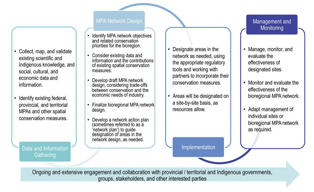
Figure 2: MPA Network Development
MPA networks take a broad view of interdependent components within an ecosystem. In an MPA network, conserved areas work together in a connected way to achieve network objectives, so that the contributions of individual sites are enhanced. These synergies translate into ecological benefits for the area and economic, social, and cultural benefits for all Canadians. Each site within a network is individually planned and managed, including any allowed or prohibited activities.
MPA network development proceeds in four stages: data and information gathering, network design, network implementation, and management and monitoring (Figure 2). All stages of network development require engagement and collaboration with all levels of government, Indigenous groups, industry stakeholders, communities, conservation organizations, and other interested parties. Working with a wide range of individuals and groups with different perspectives generates new knowledge and understanding while helping to identify common goals and alternative options and solutions.
MPA networks are not composed exclusively of Oceans Act MPAs; rather, they incorporate multiple types of conservation measures designed to afford appropriate protection to the marine environment. Establishing a conservation measure does not mean that all economic, cultural or social activity in the area will be curtailed, as there is a spectrum of conservation measures available. In the design phase of MPA network development, it is premature to make decisions about what types of conservation measures and associated management regimes will be applied in each area. These determinations are made during the implementation phase using finer-scale ecological, socio-economic, and cultural information, in combination with information and discussions with interested parties. In many cases, human activities will be allowed to continue if they do not negatively impact the measure’s conservation objectives. Network development respects the rights of Indigenous Peoples, potential or established, as set out in agreements, titles and treaties.
Section 3 of this report provides greater detail on how these socio-economic impacts are evaluated in creating individual MPAs.
The OTG emphasizes the importance of conducting as much socio-economic and cultural analysis as possible, as early as possible in MPA network development to inform selection of potential MPAs, relevant protection levels, and appropriate legislative tools.
Stage 1: Data and Information Gathering
- Gathering, mapping, and validating ecological, socio-economic and cultural data and information are critical to the success of any MPA network development process. This includes information from Indigenous knowledge systems and other forms of experiential knowledge. Indigenous Peoples can benefit most from MPAs and other conservation measures when they are part of the process to identify the habitats and species that are most important to their culture.
- Developing bioregional networks requires ongoing and extensive engagement and collaboration with governments, stakeholders, communities, and other interested parties.
Stage 2: MPA Network Design
- Working from the three national network goals, network objectives and conservation priorities for the bioregional networks are determined through the best available science and engagement of partners and other interested parties. Where possible, Indigenous knowledge holders are brought into the network design process to ensure that their perspectives and interests are respected.
- An MPA network design is drafted, showing proposed sites for conservation. This draft design considers the contribution of existing conservation measures (e.g., federal MPAs, provincial and territorial measures, marine refuges) and trade-offs between conservation and the socio-economic interests of marine users (i.e., fish harvesters, oil and gas, shipping industries, etc.). Efforts are made to minimize overlap of the draft network design with potential socio-economic activities without compromising network objectives. Adjustments to the draft design are made based on feedback received.
- Once the final MPA network design has been determined, an MPA network action plan (often referred to as a “network plan”) is developed that prioritizes the network sites and identifies the appropriate conservation measures applicable to each site.
Stage 3: Implementation
- Areas identified within the network are designated on a site-by-site basis, over time and by the appropriate authority using the relevant legislation and policies.
Stage 4: Management and Monitoring
- Once in place, bioregional networks are managed and monitored on an ongoing basis to ensure that the network goals and objectives are being achieved. As MPA networks are fully implemented in the future, socio-economic and cultural information will continue to be accumulated and integrated into the establishment process for individual MPAs to ensure informed decision making. The primary purpose of MPAs and MPA networks is protection of the ecosystem; as that ecosystem changes over time, networks may need to be adapted as new information becomes available. Principles of adaptive management also accommodate new scientific, socio-economic, and cultural information. As the need for additional (or the relaxation of) protections arise, new considerations are incorporated into network renewal.
2. Integrating Socio-Economic and Cultural Analysis in Network Design
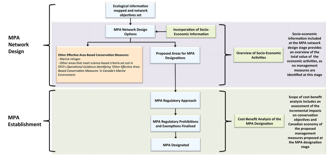
Figure 3: Socio-Economic Analysis in Network Design and MPA Establishment
Source: Economic Analysis and Statistics Directorate, DFO
Social, cultural and economic data and analyses play different roles at each of the four stages outlined in Figure 2. The type of socio-economic analysis required for the development of network design options differs in scope and complexity from what is needed during the MPA establishment phase, as illustrated in Figure 3.
Socio-Economic Analysis and MPA Network Design Options
Information and data regarding the socio-economic activities taking place in an area are combined with ecological data and cultural information, as well as information and views expressed during engagement with interested parties, to develop feasible MPA network design options. DFO has developed the Guidance on Incorporating Economic Use Information into MPA Network DesignFootnote 11 (Guidance) on incorporating spatial socio-economic data into MPA network design, including discussion of:
- the purpose and limitations of socio-economic data in this context;
- the scope and types of socio-economic data used (see Box 5); and
- options and recommendations for combining data for multiple uses in the network design analysis.
The end result of this exercise, in combination with engagement results, is the development of MPA network design options presenting multiple combinations of proposed sites that achieve the network objectives for a bioregion while minimizing potential negative overlap with economic, social and cultural activities. Where applicable, MPAs and other conservation measures target conservation of cultural values that are important for Indigenous traditional and contemporary use of the marine environment. MPAs and other conservation measures seek to maximize both ecological and cultural benefits.
The technical details of DFO’s two-step process for incorporating socio-economic data into the MPA network design process are outlined in the Guidance document.Footnote 12 Briefly, it is described as follows:
Step 1: Defining the scope of the socio-economic analysis. This is done by mapping the economic activity against the geographic area under consideration to determine which sectors to include in the MPA network design process. This requires the determination of those economic activities that directly use or depend on the resources available in the proposed geographic area, and that are anticipated to be affected by the network.
- Economic activities classified as “direct uses” encompass those that take place on or in the water, and include those that are renewable resource activities (e.g., fishing and aquaculture) and non-renewable resource activities (e.g., oil and gas, waste disposal at sea) or other human uses (e.g., recreation and tourism, transport).
- Opportunity costs are assessed based on what activities are currently occurring or likely to occur (i.e., there is a formal commitment of some type) within the next 10 years, and consideration regarding which of those activities are likely to be affected by network development. Engagement with provinces, territories and industry stakeholders (e.g., fishery, oil and gas, tourism, and other relevant sectors), other federal government departments (e.g., resource and economic assessments from Natural Resources Canada), and others informs this analysis. Other human activities that are not thought likely to be affected by network development will still be considered during site-by-site establishment processes during MPA network implementation.
- Data sources include those outlined in Box 5, as well as critical information received during consultations (see Box 6 for an example of how the St. Anns Bank MPA was established)
- In contrast, “indirect uses” (e.g., water purification by biota, climate regulation through carbon sequestration), do not involve human presence on or in the water. These uses will not be negatively affected if an area is included in the network, and therefore it is not necessary to include their associated socio-economic data in the network design analysis. Instead, many of these values are expected to be preserved by the network because they are directly derived from the ecological components that are targeted for conservation (the conservation priorities).
Box 5: Types of Economic Data and Information Sources used in MPA Network Planning and MPA Establishment
Fish Harvesting and Seafood:
- Commercial Fishing: DFO Statistics: commercial sea fisheries landings, Canada provincial-values, Indigenous commercial landings
- Aquaculture: Statistics Canada, Aquaculture Statistics, and Provincial Government Data
- Fish processing: Statistics Canada
- Employment: Statistics Canada and Provincial Government data
Contribution of Sectors to National Economy:
- Statistics Canada’s Inter-provincial Input-Output Model, Principal Statistics for Manufacturing Industries, International Trade Statistics, Labour Force Statistics, Small and Medium Size Enterprises (SME Benchmarking Tool), etc.
Oil and Gas and other Energy and Mineral Resources:
- Natural Resources Canada (resource and economic assessments)
Transportation:
- Marine transportation: Canada Revenue Agency
- Transport Canada Data
- Mean traffic density of all ships should be used to reflect the importance of planning units to this sector.
Tourism and Recreation:
- Recreational fishing: DFO Survey of Recreational Fishing
- Cruise Ships: Statistics Canada Tourism Satellite Survey
- Recreational Travel: Statistics Canada public use microdata travelers’ file and traveler data
Source: Economic Analysis and Statistics Directorate, DFO
Box 6: Consultation and Engagement Activities during the Selection and Establishment of the St. Anns Bank MPA
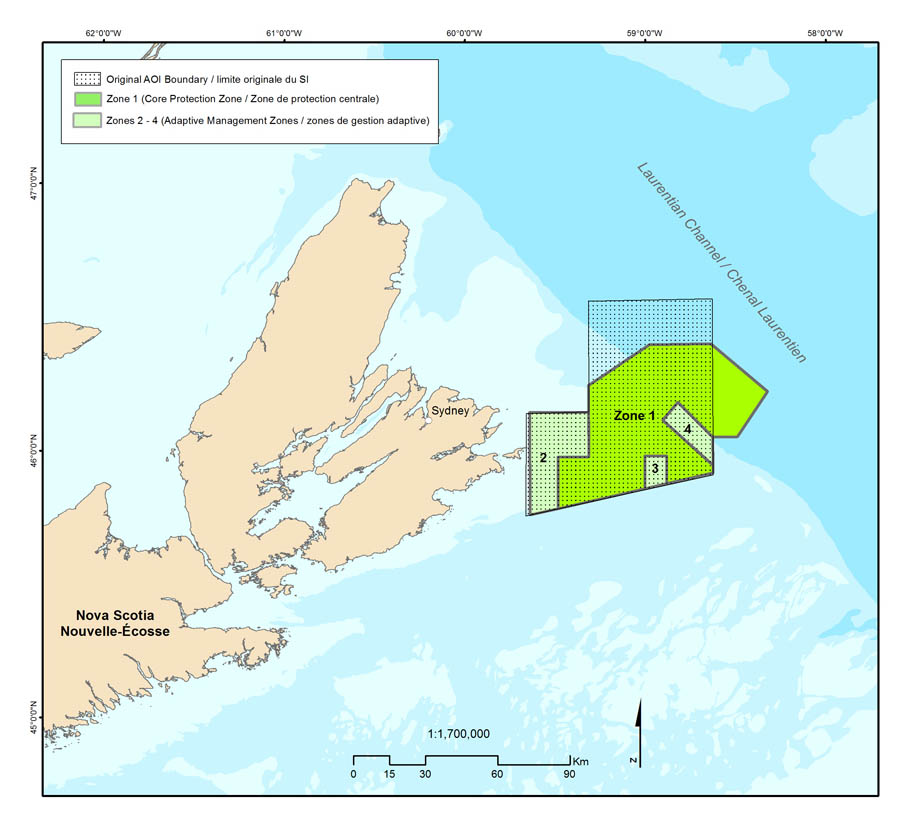
St. Anns Bank, showing original and final boundaries.
The St. Anns Bank MPA was officially designated under the Oceans Act in June of 2017. The site was announced as an AOI in June of 2011, and the majority of the technical work and consultations associated with this site occurred over a two-year period that ended in April 2013. In total, there were three distinct phases of consultations during the process to select and designate this area as an MPA.
AOI Selection Phase
The first phase of consultation was a public process between October 2009 and May 2010 where the objective was to gather feedback from marine users, First Nations and Indigenous organizations, government agencies, and the public on three candidate AOIs. The consultation period was extended from two to seven months to accommodate stakeholder concerns with the process. Input was captured through online feedback forms (158), formal written submissions (24), phone conversations/teleconferences (53), emails to the Minister of DFO (7), and face-to-face meetings with a variety of industry groups, government agencies, and other interested parties (70). A series of bilateral meetings with stakeholders, First Nations and Indigenous organizations, and the Province of Nova Scotia took place following the public consultation process. St. Anns Bank AOI was ultimately selected because, in addition to its high ecological value, it received the most direct support and was expected to have the lowest economic impact among the candidates.
MPA Design Phase
The MPA design phase included a series of technical steps that ran in parallel with a period of intensive consultation. The technical activities included an ecological overview (a scientific peer-review process that described the ecosystem and identified the conservation priorities for the MPA), a socio-economic assessment (which described current and potential human uses of the area and their value), and an ecological risk assessment (which evaluated the threat of existing activities to the conservation priorities for the MPA). The St. Anns Bank AOI Stakeholder Advisory Committee (Advisory Committee) was established shortly after the site was announced as an AOI, and was made up of representatives from industry, academia, environmental non-governmental organizations, other provincial and federal government regulators, and First Nations and Indigenous organizations. Between April 2012 and April 2013, the Advisory Committee met four times (in Cape Breton) to help design the MPA. This included reviewing available ecological and human use information, contributing to the development of the conservation objectives, providing input on the MPA boundary and zones, and offering advice on allowable activities.
A series of bilateral meetings (e.g., Province of Nova Scotia, First Nations) were held in addition to the Advisory Committee meetings. Information was also distributed to First Nations through formal letters. A Fishing Industry Working Group was also established to ensure all interested harvesters (including First Nations) and processors had an opportunity to participate in the process. This technical work, coupled with the Advisory Committee, Working Group, and bilateral meetings played a major role in defining the MPA boundary, the zones within it, and the fishing activities permitted in those zones. The proposed MPA boundary that emerged from this phase (see map) was significantly different from the original AOI boundary and resulted in reduced overlap with several current and potential economic activities, such as oil and gas, and mobile-gear fisheries.
Regulatory Phase
Following consultation, DFO and the Department of Justice developed draft MPA Regulations for consideration in the Federal regulatory development process. The draft regulations were published for a 45-day public comment period in Canada Gazette l in December of 2016. This included a description of the costs and benefits of the proposed Regulations. Close to 1000 comments, including suggested changes to the Regulations, were received from interested stakeholders and the public. After careful consideration, the Regulations were revised to include a modification to one of the zones to address some of the concerns from several fish harvesters. The regulations were registered and published in the Canada Gazette II in June 2017, establishing an MPA encompassing 4,364 km2.
Since its designation, there have been ongoing efforts made to increase the overall ecological knowledge of the area to support effective management and establish effective mechanisms for ongoing engagement. Work is underway on the development of a St. Anns Bank MPA management plan which will help guide future activities and decisions related to managing the MPA. The establishment of an ongoing St. Anns Bank Advisory Committee to support management activities is a priority action item. Compliance and enforcement activities are carried out by DFO enforcement officers and include vessel and aerial patrols to ensure compliance with fishing licence conditions and closure areas.
Step 2: Determining the value of these sectors to the geographic areas in the bioregion. This step is conducted after the sectors to be included in MPA network design analysis are confirmed. The purpose of this exercise is to spatially represent the value of each socio-economic activity.
The socio-economic information generated in the two steps outlined above is intended to assist development of MPA network design options in meeting network objectives, including associated quantitative (i.e., percent) targets, as applicable, while minimizing overlap with areas identified as having important socio-economic activities. The resulting MPA network design option maps provide an objective and transparent representation of the conservation priorities and the socio-economic importance of the area to inform decision making, accounting for a broad range of considerations, stakeholders, and trade-offs in an inclusive and iterative way.
As described above, consideration of future activities is limited to those where there is some formal commitment to allow them in the near future (i.e., within the next 10 years). This would include activities for which a clear intent to undertake the activity (e.g., business plans, permits, submission of plans for approvals, etc.) can be established. At the same time, it is important to remember that new data, such as results of MPA network monitoring, will emerge over time as sites identified in MPA network designs are established. Adaptive management is an important component of MPA network development that makes use of best available data over time to ensure that the network is effective in meeting its objectives. Any proposed adjustments to the network design to ensure that network objectives are met will also consider economic impacts of those potential adjustments, including best available data about future activities.
The OTG acknowledges the importance of governments working together to achieve common marine protection and conservation goals.
Two Approaches to Developing Network Design Options

Orca in the Northern Shelf bioregion (photo: DFO)
There are several different ways to produce MPA network design options. In bioregions where data are readily available, software-based analysis is possible using a decision-support tool such as Marxan, which can support creation of potential MPA network design options that meet conservation targets while minimizing overlap with areas identified as having important socio-economic activities. The way in which software-based analysis using Marxan can inform a specific network design is illustrated in Figure 4.
In some bioregions, data are not available at the scale of the planning area or in a format that allows for the use of decision-support software. In these cases, network development is done using a qualitative, or Delphic, approach through interviews and surveys of experts or community elders who have traditional, historical or contemporary familiarity with the human-use activities conducted in the area. The network development process in the Western Arctic bioregion relies on both a qualitative approach as described in Box 8, but is also incorporating Marxan, or similar decision-support tool, for areas and layers of information that are suitable for this treatment.
Box 7: How Decision-Support Software Works
Decision-support software (such as Marxan) is often used to help develop MPA network design options as it allows network planners to generate as many potential scenarios as needed to produce results that meet conservation targets while minimizing the potential overlap with economic activities, to the extent possible. These scenarios can be refined as needed, based on expert knowledge and additional analyses, to create one or more MPA network design options that will ultimately lead to the creation of a draft MPA network design for subsequent engagement.
Marxan is designed to address the general problem of optimizing user-defined “targets” when faced with potentially competing objectives. This is highly applicable to Canada’s marine environment where there are often numerous competing objectives, users, and industries. Conservation priorities often coincide with important human-use areas (such as fishing grounds); Marxan is a useful tool in helping to identify areas for conservation that have high conservation value but lower economic value.
Software generates options for consideration; it does not make decisions.
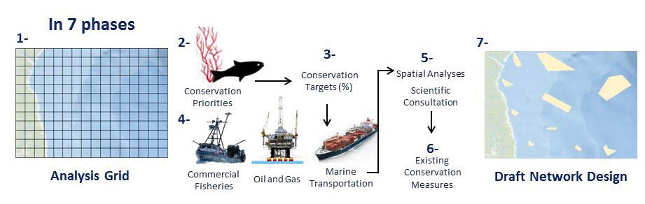
Figure 4: The Network Development Process
Phase 1: Divide the bioregion into km2 units.
Phase 2: Define the conservation priorities.
Phase 3: Assign conservation targets for conservation priorities.
Phase 4: Factor in socio-economic activities
Phase 5: Use a decision-support tool (such as Marxan) to facilitate spatial analysis; consult scientists and economists.
Phase 6: Factor in existing conservation measures.
Phase 7: Produce a draft MPA network design that helps achieve ecological conservation targets while minimizing impacts on socio-economic activities.
Box 8: Network Development in the Western Arctic Bioregion
In the Western Arctic, the conservation and protection of traditional-use species and areas, culturally significant areas and archeological resources are as important as the conservation and protection of unique or sensitive species, ecological features, and habitat types. The Western Arctic is a bioregion rich in local and Indigenous knowledge, both Ilisimaun Sumunsuli in the ISR and Inuit Qaujimajatuqangit in Nunavut. The most effective approach to ensuring that both ecological and cultural priorities are included in network planning is through community consultation (conducted in this bioregion through a community tour) to collect information on subsistence harvest priorities, and combining this information with existing science advice on ecologically and biologically significant areas and species.
A draft MPA network design will be produced using a hybrid approach, combining Marxan analysis with an iterative Delphic approach in communication with co-management partners, science experts, industry representatives, and community members. This methodology will enable the inclusion of knowledge about all aspects of activities occurring within the bioregion, and allows information available at the bioregional scale, as well as more localized information, to be incorporated effectively into the design.
Socio-economic information will also be included in the analysis to reflect current non-renewable resource use and lease information, as well as the activities of other industries currently underway in the bioregion (i.e., shipping, tourism). These data will inform the spatial analysis method for site identification and site placement that will minimize disruption of economic activities in the area while meeting network objectives at the bioregional level. A draft MPA network design will be shared for review in community consultations and through meaningful engagement with co-management partners, industry, and other stakeholders. This process will be an essential element in providing a comprehensive review of the draft design and assessing recommendations for conservation measures while addressing the needs and concerns of all users in the bioregion.
The consultation process will be critical in establishing support for moving toward the next steps in MPA network development, including implementation of new sites and creating management and monitoring plans. External engagement in MPA network planning in the Western Arctic is currently on hold to enable adequate time for discussions with partners to develop support for this initiative. Next steps toward site identification or site selection will not proceed without the support of co-management partners, industry representatives, stakeholders, and community members.
The OTG emphasizes the importance of seeking the broadest range of input, views and values from Indigenous knowledge holders and stakeholders as early as possible in MPA network development.
Regardless of the approach, the result forms the basis for more substantive discussions on MPA network design options and reflects a key point for engagement. In this design stage of the MPA network development process, decisions regarding the types of conservation measures to be applied in each area have not been taken. Therefore, this socio-economic analysis does not evaluate the cost and benefit impacts of the MPA network design options; rather, it provides an overview of the current socio-economic activities in the geographic area under consideration and provides insight into the regional and distributional importance of the proposed network sites to the interested parties. A draft MPA network design, or potentially several network design options, is discussed with partners, stakeholders, and other interested parties and feedback is received, before finalizing the MPA network design and proceeding to the implementation stage of the process.
The analysis of the costs and benefits is undertaken using finer-scale ecological, socio-economic, and cultural information during the implementation phase (i.e., during MPA establishment) when information on the specific conservation measures becomes available.
Descriptions of socio-economic activities, together with information about the conservation aspects of proposed sites in the network design and any other characteristics of interest, are part of a process that involves more detailed engagement with stakeholders. It is those more detailed processes that ultimately inform decision making on a final MPA network action planFootnote 13 and the regulatory tools that will be used to ensure conservation.
The OTG emphasizes the importance of a consistent approach to MPA network development and the use of marine conservation tools across Canada’s three oceans. Early engagement of jurisdictions, partners and stakeholders in these processes, including analysis of socio-economic and cultural activities that may be affected, is also important.
Box 9: Balancing Conservation Objectives and Socio-Economic and Cultural Impacts
When implementing conservation objectives, two broad principles are considered. The first is the total impact of the network on current and future economic users. The second is the distribution of impacts arising from an MPA network across individuals and groups.
The goal at the network development stage is typically to maximize the ecological and socio-economic benefits while minimizing the socio-economic costs. There may be cases, however, where the option with the lowest socio-economic costs imposes notably unbalanced costs on a specific group or community. In such a situation, the best option may be one with slightly higher but more equitable costs.
There may also be cases where the ecological importance is so great that some socio-economic considerations cannot be accommodated, or where socio-economic significance is so great that areas would be deemed inappropriate for setting aside as marine protected areas.
Determining the balance between economic uses and conservation objectives is a step undertaken in collaboration and engagement with the interested parties.
Source: National Framework, p. 13.
3. Socio-Economic Analysis in MPA Establishment
DFO and ECCC establish protected areas using regulatory processes mandated by their legislation. The following section outlines the regulatory process, using MPAs established under the Oceans Act as an example. The PCA process is described in Box 10.
The socio-economic data reflected in the MPA network design is further elaborated for any specific network site that is identified as an AOI through a socio-economic overview. This overview report, which details the economic activities and the key interested parties involved within the boundaries of the AOI, also serves to inform the consultations with interested parties leading up to the decision regarding specific measures outlined in the proposed MPA regulations.
The process for Oceans Act MPA establishment is iterative, with the socio-economic analyses evolving alongside. Each step connects to the next. The ecological information from the bioregional MPA network development contributes to a preliminary indication of sectors that may be implicated by the establishment of an MPA, and informs discussions with stakeholders and interested parties. This information is further refined through continued analysis and consultation during the MPA establishment process.
This socio-economic overview report builds on the information provided in the MPA network design by focusing on the selected geographic boundary for the AOI. The report provides an in-depth assessment of the socio-economic activities that are currently taking place or are dependent on the resources in the area, as well as those expected to occur in the future, with respect to those industries that have existing operations in the area. The purpose of the socio-economic overview report is to inform consultations and engagement initiatives, and the scope of this report includes a profile of the interested parties based on a historical trend analysis. The analysis draws on data for key economic indicators such as GDP, fishing landed value, employment, number of establishment or other entities, revenue, trade, demographic profile of the area, etc., at the provincial or regional and national scale. The report also includes a brief summary of the unique ecological characteristics of the area and the reason for conservation, an outline of the existing risks and the protections currently in place, and a discussion of the existing national and international commitments.
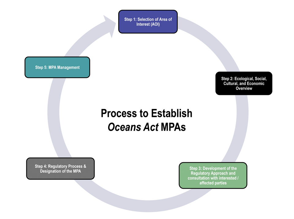
Figure 5: Process to Establish Oceans Act MPAs
Socio-economic and cultural information is an important element of steps 2, 3 and 4 in the Oceans Act MPA establishment process. Step 2 includes an overview report that incorporates ecological, social, cultural and economic information. Interested and affected parties may contribute information based on their expertise in their field, or the local or Indigenous knowledge they hold. Step 3 includes the proposed MPA regulatory approach which is developed based on the best available science, including Indigenous and local knowledge, an understanding of human uses, a risk analysis of the impacts of those human uses on the conservation objectives of the site, and consultations with provinces, territories, Indigenous Peoples, and stakeholders. Step 4 is the regulatory process which includes publication of the Regulatory Impact Analysis Statement (RIAS) where socio-economic and cultural considerations are detailed and made available to Canadians for comment.
Box 10: Establishing National Marine Conservation Areas
National marine conservation areas (NMCAs) and NMCA reserves are established and managed by the Parks Canada Agency to protect and conserve areas representative of the 29 marine regions covering the Atlantic, Arctic and Pacific Oceans and the Great Lakes described in the NMCA system plan. NMCAs and NMCA reserves are established using the following process:
Identify and Select Area:Parks Canada works to identify a number of marine areas that are representative of the biological, geological, oceanographic and cultural features of a given marine region and that could merit protection as an NMCA. One of these sites is then selected as the best candidate to represent the marine region.
Assess Feasibility: Should there be support from implicated provincial and territorial governments and Indigenous governments and organizations, an assessment of the feasibility and desirability of protecting a specific site as an NMCA is undertaken, including consultations.
Decision on Feasibility: Based on the results of the feasibility assessment, the relevant Parties determine whether establishment of an NMCA should proceed, including a potential boundary.
Negotiate Agreements and Develop Interim Management Plan: Should the Parties agree that protecting a specific site is feasible, negotiation of an establishment agreement or agreements is undertaken, setting out the terms and conditions under which the area will be administered and managed, including the final boundary and the transfer of any lands/seabed to the federal government. At the same time, an interim management plan is developed through consultations to guide management during the first five years of operations.
Establish in Legislation: The area is formally designated under the Canada National Marine Conservation Areas Act by amending the Act to add a description of the boundary of the NMCA (or NMCA reserve) to the schedule.
Note: An NMCA reserve is established and managed in the same manner as an NMCA, but its status is subject to the resolution of a claim or claims in respect of Indigenous rights.
Source: The Parks Canada Agency
The socio-economic overview report presents the policy and economic baseline for the next phase of economic analysis of the MPA establishment process. The overview report provides a profile of the economic sectors within the proposed geographical boundary of the AOI. An analysis of the costs and benefits of the impacts is not undertaken at this stage, given that actual management measures for the proposed MPA are yet to be determined.
A CBA is undertaken once the specific management measures (prohibitions and allowed activities) to be utilized in the proposed MPA (developed through engagement with interested parties) have been finalized. The CBA evaluates the incremental impacts (costs and benefits) of the regulatory requirements for the MPA regulations on the interested parties over a period of time in the future. At the CBA stage, once regulatory measures, prohibitions, and allowed activities are known, impacts on future economic opportunities can be identified and reflected in the report. In the case of Oceans Act MPAs, the CBA is carried out in accordance with federal government requirements outlined in the Cabinet Directive on Regulatory Management (CDRM). In addition, DFO has developed the Framework for Integrating Socio-Economic Analysis in the Marine Protected Areas Designation Process Footnote 14 (Framework) specifically for the MPA establishment process aligned with the CDRM.
MPAs follow a life-cycle approach, and stakeholder involvement is important to the management, monitoring, evaluation and review of the effectiveness of any MPA. Stakeholders provide input into draft MPA management plans and their subsequent revisions. Monitoring and evaluation play an important role in the life cycle of MPA management with respect to assessing progress toward conservation objectives and determining the need for adaptive management to better achieve the conservation objectives.
Changes in eco-tourism in the Gully MPA, for example, triggered a need for adaptive management – not only to ensure that the natural biological life functions protected by the MPA were not altered by eco-tourism, but also to allow the area to be visited both for the economic benefit of tour operators and the opportunities for public engagement and education.
The OTG supports an adaptive management approach which recognizes that ecosystems are dynamic and therefore the values associated with their functions need to be quantified. To be effective at MPA network and site levels, this approach, although costly, requires integrated monitoring and reporting.
The CBA is a broad tool that evaluates the incremental cost and benefit impacts of policy interventions, using a common baseline. It is an overarching framework embodying the concept of incrementality by comparing the “with” and “without” intervention scenarios. In this context, the CBA would examine impacts from the designation of an Oceans Act MPA compared to a scenario without the MPA. For this purpose, the regulatory and non-regulatory management measures that are currently in place, or are proposed and approved for implementation, are outlined as the baseline against which the proposed regulatory requirements of the MPA are compared [e.g., assessing the change in fishery landings (loss in fishery, tourism, oil and gas revenues or profits) from a complete prohibition of fishing activity in the area designated as an MPA, as well as estimating the change in fishery population biomass as a consequence of the prohibition and potential spillover impacts to adjoining areas]. The former (prohibition of activities) are referred to as cost impacts, while the latter (spillover impacts) are assessed as potential future benefits, namely increased harvest levels in the adjoining areas.
Thus, a CBA clearly identifies the economic sectors and other interested parties that would be negatively impacted by the MPA designation and those that stand to positively gain from such a designation. A robust socio-economic analysis (see Box 11) clearly specifies the costs and the benefits of the proposed MPA designation over a period of time to ensure that the relevant information is available to inform consultations and decisions.
Evaluating Socio-Economic Impacts in MPA Establishment
While there is always an effort made during MPA network development to provide a broad-scale balance between achieving network objectives and minimizing social, economic and cultural impacts, specific costs can only be itemized and quantified at the CBA stage in site-by-site establishment processes. This in-depth analysis is governed by the design of the management approach. Specifically, more detailed socio-economic impact analysis becomes possible as the management approach evolves for each site and informs the extent to which human activities may continue while meeting the conservation objectives for the site. In conducting this analysis, it will often become apparent that costs may have been minimized, but not completely eliminated. It should be noted that in order for a regulatory action such as MPA establishment to occur, a net benefit to Canadians needs to be demonstrated.Footnote 15
Some costs stem more directly from ongoing MPA management while others represent opportunity costs, such as the potential for lost future revenue due to restrictions on fishing or marine resource use. For example, if MPA management includes halting commercial fishing activity in an area, expected losses from this action would be projected into the future. If management options include prohibitions on non-renewable resource extraction activities such as oil and gas, the value associated with extraction and exploration licences in the area would be projected. The national approach is for areas with production licences and significant discovery licences to be locked out of MPA network design options, and hence these licences would not be affected by the establishment of an MPA, in bioregions where MPA network development is underway.
At the same time, the management measures will also impact biological and ecological outcomes and as such, consideration must be given not only to the costs, but also the benefits of such measures. The restrictions on fishing, mineral extraction or any other economic activity are imposed as a response to manage threats to the ecosystem services. Managing threats can therefore reasonably be assumed to result in some positive outcome with respect to the ecosystem service in question, including, for example, higher fisheries harvests outside of an MPA, should an increase in biomass stem from the protected area. In order to evaluate the benefits, the ecological outcomes of the management measures are modelled to provide an estimate of the economic value. The incremental costs and benefits provide the necessary information to assess the magnitude of the net benefits to the Canadian economy and society.
Summaries of several international studies and reports documenting MPA effectiveness and their socio-economic and cultural benefits can be found in Annex 2.
4. Integrating Social and Cultural Analysis in MPA Network Design and MPA Establishment Processes
Network development is an iterative process that requires ongoing engagement to facilitate the collection of human-use and cultural information, including, for example, the identification of areas sacred to Indigenous Peoples or places valued by others for recreational, historical or spiritual reasons.
Local harvesters and residents may hold valuable information acquired through extensive experience and direct interaction with the marine environment. This information – which can be an important element in network development – can only be gathered through engagement with those who have a cultural connection to the area in which MPA network development is underway. Indigenous people also hold valuable information about the habitats and species that are most important to their culture, for food, social and ceremonial purposes.
Box 11: Example of Socio-Economic Analysis for Anguniaqvia niqiqyuam MPA
The regulatory process has evolved over time, in parallel with MPA establishment. While common elements have been present in all, the Anguniaqvia niqiqyuam (AN) MPA establishment process is an example of establishment under current practices.
In the early stages, conservation objectives were determined. Draft or potential MPA boundaries were produced based on those objectives and efforts to minimize impacts to human use were identified based on available information. The potential MPA boundaries, along with information used to draft them, were taken to consultation and engagement sessions to determine other human activities that could be affected by any potential MPA boundaries. These consultations provided input on how the boundaries could be better positioned to best avoid impacting human use, and flagging potential exemptions or prohibitions that could cause positive or negative impacts. Thus, while it is not possible to conduct formal socio-economic or cultural impact analysis at this stage due to the evolution of the MPA boundaries and management measures, a tremendous amount of socio-economic and cultural information feeds into the process. While there is no place to readily highlight the socio-economic or cultural impacts avoided as a result of this input later in the process, such information plays a central role in both developing the MPA boundaries and allowing many MPA establishments to achieve low impact status.
Management measures, prohibition and exemption scenarios were developed following identification of the potential MPA boundaries. At this stage it was possible to conduct a CBA. Based on input received during consultations and known socio-economic activity occurring in the area, the costs and benefits to the following key sectors were assessed:
Costs of Designation: MPA management costs may result in opportunity costs from restrictions on: commercial fishing, recreational fishing, mineral exploration and production, recreational activities, and commercial shipping.
Benefits of Designation: subsistence fishing, recreational fishing, recreational activities, option value, non-use values, and archaeological and historical values.
The analysis found that the present value of the main costs associated with establishment of the MPA would total approximately $1.8 million over 20 years, including opportunity costs and ongoing MPA management costs.Footnote 24 Due to a lack of information, the benefits could not be assessed quantitatively. However, in addition to the ecological benefits, the analysis found that establishment of the MPA would ensure the area’s ability to continue contributing to the subsistence harvest of fish and marine mammals, and preserve the traditional ways of life of the Paulatuk community. The designated area is also predicted to create recreational activity opportunities.Footnote 25
These findings were then used to draft the Regulatory Impact Analysis Statement, published in the Canada Gazette.
While Indigenous and cultural use information is critical to developing the socio-economic and cultural layers that inform MPA network development, it is not always easy to access. There can be apprehension about sharing sensitive or culturally significant information, and there is often difficulty in interpreting information or translating it accurately into maps. Language barriers can also create impediments to understanding.
In 2008, DFO established the Centre of Expertise for Traditional Ecological Knowledge to develop a national approach to using Indigenous knowledge to address ocean management challenges. The Centre created several documentsFootnote 16 to provide advice on how best to incorporate this information into the day-to-day work of ocean planners.
While the information compiled has helped to ensure that Indigenous knowledge is integrated with scientific conservation considerations at an early stage, often in the identification of EBSAs, more work needs to be done to ensure that Indigenous knowledge, perspectives and interests are reflected within the required socio-economic analyses. The economic language of socio-economic analysis (and the CBA) can incorporate certain impacts to Indigenous communities (e.g., impacts on commercial communal fishing and subsistence fishing) where available. However, using dollar metrics and concepts of isolated incremental impacts is often not compatible with the holistic perspective that is reflected in Indigenous knowledge systems.
Nevertheless, any impacts (e.g., food, social and ceremonial uses) to Indigenous communities could be qualitatively described in the RIAS where available, and published in the Canada Gazette. References to more comprehensive assessments, where they exist, should also be included. Reflecting Indigenous considerations in various documents such as the RIAS can illustrate how the MPA establishment process benefits from Indigenous knowledge.
Box 12: Laying the Groundwork for Marine Spatial Planning in British Columbia
Effective marine spatial planning relies on comprehensive ecological and human-use data, which requires a significant collaborative effort across governments, scientists, stakeholders, and communities to collect. In 2006, the British Columbia Marine Conservation Analysis (BCMCA) project was initiated to capture information on ecological features, the physical marine environment, and all marine activities, and subsequently map them on a coast-wide basis. The human-use themes included marine areas important for commercial fisheries, recreational fisheries, shipping and marine transportation, ocean energy, recreation and tourism, and marine or foreshore tenures such as aquaculture or log booms. Data sets were assembled from existing sources including government databases, academic research results, and participatory mapping exercises.
In 2011, the BCMCA released its Marine Atlas of Pacific Canada - a rich set of maps and descriptive information that would help lay the groundwork for marine planning and management initiatives, such as the Marine Plan Partnership (MaPP). Through MaPP, the Government of British Columbia and 17 First Nations developed marine spatial plans for the Northern Shelf. Ecological, cultural, and human-use data sets were supplemented with extensive knowledge held by Indigenous communities and brought together in Marxan to identify areas of high conservation value and importance to a variety of marine users. The zones allocate space for different purposes including the protection of ecologically and culturally significant areas, and the provision of opportunities for sustainable marine economic development.
While the BCMCA project required significant time and effort to complete, the investment resulted in an impressive resource for a variety of applications including habitat management, marine ecology, environmental assessments, oil spill response, integrated marine spatial planning, and marine protected area planning.
Box 13: Example of the Integration of Social, Cultural and Economic Information – Tallurutiup Imanga National Marine Conservation Area
Association (QIA) signed a Memorandum of Understanding agreeing to final boundaries and interim protection for the 109,000 km2 Tallurutiup Imanga National Marine Conservation Area (NMCA) in Lancaster Sound, pending completion of the Inuit Impact and Benefit Agreement.
The announcement was based on recommendations from the feasibility assessment report produced by representatives of each of the Parties and tabled with governments and QIA to provide them with the necessary information to make an informed decision with respect to the NMCA.
Over the course of the feasibility assessment, information was gathered on ecological values, tourism opportunities, fisheries, marine transportation and potential hydrocarbon resources (including two resource assessments completed by the Geological Survey of Canada). Consultations were conducted in local communities and input was solicited from regional and national stakeholders including industry and non-government organizations. Inuit Qaujimajatuqangit (Inuit traditional knowledge) was used alongside contemporary science to get a more complete understanding of the use and value of the area and proved to be fundamental in understanding and illustrating the Inuit perspective of the region. These developments led to a more universal ecological and social outlook on the proposed NMCA.
The report concluded that the establishment of a national marine conservation area in Lancaster Sound could provide numerous ecological and social benefits, including:
- conserving the rich biodiversity and maintaining ecological processes of the Lancaster Sound marine ecosystem for the benefit of marine species, Nunavummiut and Canadians;
- establishing a collaborative relationship between Canada and Inuit that would guide current and future activities in Lancaster Sound to ensure the ecological and cultural viability of the area;
- protecting and conserving species at risk and their habitats;
- protecting the Inuit way of life and Inuit traditions through conserving the marine environment and wildlife food sources;
- allowing all activities within the NMCA, including fisheries and marine transportation activities, to be managed in a more ecologically holistic manner;
- protecting historical resources, such as shipwrecks and archaeological sites;
- providing opportunities for visitors to experience and appreciate this environment;
- encouraging ecological research and monitoring;
- providing a level of resilience to the fragile Arctic marine ecosystem facing climate change; and
- encouraging ecologically sustainable economic opportunities in the region.
The following were considered when delineating a boundary for an NMCA in Lancaster Sound:
- the views of local Inuit communities;
- the ecological values identified through contemporary science and Inuit Qaujimajatuqangit;
- Inuit traditional use of the Lancaster Sound region;
- cultural values;
- hydrocarbon resource assessments, particularly considering that the only remaining industrial hydrocarbon exploration permit in the area was voluntarily relinquished;
- the views of stakeholders; and
- government priorities and commitments.
Source: A National Marine Conservation Area Proposal for Lancaster Sound -- Feasibility Assessment Report. (2017). Submitted by the Lancaster Sound National Marine Conservation Area Feasibility Assessment Steering Committee.
Experiential forms of knowledge, together with science and research, are critical elements that inform identification of network objectives and conservation priorities, and which in turn inform conservation objectives for MPAs and other conservation measures that are established as MPA network implementation occurs.Footnote 17 MPA network development is a highly iterative process that combines consideration of potential social, economic and cultural impacts, ecological information, network objectives, and conservation priorities in detailed engagement and discussions with partners, stakeholders, and other interested parties. These complex interrelated processes and considerations ultimately inform decision making on a final MPA network design and subsequent MPA network action plan.Footnote 18
- Date modified: