
St. Lawrence Lowlands priority place
Location
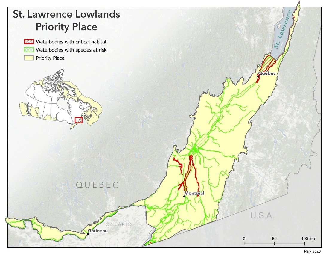
The St Lawrence Lowlands in Quebec are a large area (29 000 km2) along the border of the St Lawrence River. This is an area known for its rich agriculture and is where the majority of the population of the province of Quebec is concentrated.
The boundaries of the study area correspond to the natural province of the St. Lawrence lowlands of the Quebec reference Ecological framework.
Aquatic species at risk are found in the St. Lawrence River and in many of the watersheds of the St. Lawrence lowlands, such as the Ottawa River, Chateauguay River, Assomption River, and in the majority of rivers flowing into Saint-Pierre Lake. The Richelieu River,contains 12 of the 14 aquatic species at risk in the St. Lawrence Lowlands
Key threats
Pollution from agricultural and municipal contaminants is a major threat that is widespread throughout the St. Lawrence Lowlands that affects all species that are present.
Habitat modification or disturbance, including barriers to free fish passage and the presence of invasive species (plants or animals), are also common and important threats to species in the lowlands of the St. Lawrence.
Aquatic SARA Schedule 1-listed species at risk found at the St. Lawrence lowlands priority place
| Priority Places and Marine Threats | Species, Population | SARA status |
|---|
Examples of recovery activities that DFO is seeking to support in the St. Lawrence lowlands priority place
- Conservation and protection of aquatic and riparian habitats, to ensure the sustainability of restored habitats including measures to increase the area of preserved or protected riparian areas
- Development and implementation of measures to improve agricultural practices and municipal wastewater management, including raising awareness among key stakeholders. Ex: riparian habitat improvement, installation of bridges or other structures to keep human activities out of the water, installation of fences or off-site watering stations to prevent animals from entering the water, etc
- Development and implementation of measures to reduce nutrient, pesticide and sediment inputs to aquatic systems
- Development and implementation of targeted plans for better control of invasive species affecting aquatic species at risk, including the awareness and research needed to develop these plans
- Development of indicators and monitoring plans to monitor populations of species at risk and their habitats
- Restoring the quality of degraded aquatic and riparian habitats, including flow management, fish passage enhancement, shoreline restoration, sediment control, spawning habitats (e.g., grass beds, wetland creation, cold-water habitat creation) and those affected by fragmentation and degradation (e.g., removal or modification of barriers to fish passage, mitigation of bank erosion)
- Activities that support partnerships, relationship building, and the establishment of venues for continued collaboration, and information and knowledge sharing to support recovery actions
- Targeted activities to improve awareness and increase opportunities for stewardship and partnership activities (presentations to environmental non-governmental organizations, aboriginal groups, etc.). Targeted outreach to different audiences to improve knowledge of species at risk and their habitat needs, promote recreational fishing regulations, best practices for tourism, recreational boaters and promote actions that can enhance the recovery of species at risk
Learn more about projects in this area
Restoration of aquatic and riparian habitats in the St. Lawrence River between Montreal and Lake Saint Pierre and its main tributaries on the south shore
Restoration of aquatic and riparian habitats in the St. Lawrence River between Montreal and Lake Saint Pierre and its main tributaries on the south shore
Recipient: Nature Conservancy of Canada
Project goal:This four-year project is intended to enhance the habitat of aquatic species at risk in the St. Lawrence Lowlands Priority Area, in particular around the islands in the St. Lawrence River between Montreal and Saint-Sulpice, in Lake Saint-Pierre and in the watersheds of the six main tributaries on the south shore of the St. Lawrence: the Châteauguay, Acadie, Richelieu, Yamaska and Saint-François Rivers and the Rivière du Sud.
The purpose of this project is to address threats considered a priority by the Nature Conservancy of Canada and its partners, i.e. eroding shorelines, shoreline alteration, degradation of riparian habitats and invasive species. To this end, six major activities will be carried out in the different water bodies targeted: 1) characterization of the composition and extent of aquatic grass beds; 2) control of invasive alien species; 3) stabilization of eroding shorelines and restoration of aquatic habitats; 4) characterization and restoration of riparian habitats and implementation of agri-environmental practices in the farming areas located in the subwatersheds targeted; 5) restoration of canals and watercourses; and 6) raising awareness among users of these water bodies so that they can recognize and assist in protecting the habitat of target species at risk.
In the long term, the benefits of these measures will strengthen the impact of interventions on improving water quality and enhancing the habitat of target species.
Fund Allocation:
$1,465,226
Time Frame:
4 years
Species that benefit from this project:
Adoption of agri-environmental practices by farmers in the Rivière des Hurons watershed to improve water quality and enhance riparian habitats of at risk fish species in the Richelieu River
Adoption of agri environmental practices by farmers in the Rivière des Hurons watershed to improve water quality and enhance riparian habitats of at risk fish species in the Richelieu River
Recipient: Fédération de l’UPA de la Montérégie

Project goal: The goal of this four-year project is to encourage producers in the Rivière des Hurons watershed to adopt agri-environmental practices to improve water quality and enhance the aquatic habitat of five fish species at risk in the Richelieu River and Rivière des Hurons. These practices are aimed at reducing runoff of agricultural pollutants (e.g. sediments and pesticides) into waterways throughthe use of cover crops in crop rotation management, proper management of rainwater using agricultural water management structures, revegetation of riparian buffers and stabilization of severely eroded shorelines. Other project activities will focus on building knowledge of the watershed’s hydromorphology as well as on the sharing and transfer of knowledge to facilitate the adoption and improvement of agricultural practices by producers within the watershed.
To accomplish this, the Fédération is working in collaboration with producers and various agricultural, municipal and environmental partners in the Rivière des Hurons watershed.
Fund Allocation:
$707,015
Time Frame:
4 years
Species that benefit from this project:
- Date modified: