
Introduction to the Coastal Environmental Baseline Program
On this page
- What is the Coastal Environmental Baseline Program?
- How does the Baseline Program work?
- Locations
- Projects
- Partners and engagement
- Establishing a baseline
- Data collection and management
- Glossary
- Contact us
What is the Coastal Environmental Baseline Program?
Coastal ecosystems are known to provide important ecosystem services, especially for Indigenous and local communities living along the coast. These ecosystems are facing strong pressures, such as climate change, marine traffic and development, that can jeopardize their ability to provide the services they deliver to coastal communities. In Canada, coastal communities have raised concerns regarding the potential impacts of those pressures on the coastal ecosystems. They rely on the coasts for their activities and livelihoods.
We established the Coastal Environmental Baseline Program (Baseline Program), in 2017. This program is one of a number of initiatives created under the ‘Protecting the Marine Environment’ pillar of the Government of Canada’s Oceans Protection Plan. With an initial investment of $50.8 million over 5 years, the Baseline Program aims to contribute to the protection of Canada’s coasts and waterways.
The overarching goal of the Baseline Program is to support the collection of ecological data to describe the current state (baseline) of key coastal areas across Canada (see map). The data collected will contribute to the characterization of important coastal ecosystems in Canada and support evidence-based assessments and management decisions.
The Baseline Program was built in close partnership with local communities and stakeholders along Canada’s Arctic, Atlantic and Pacific coasts, including First Nations, Inuit, environmental non-government organizations, fisheries associations, academia and local governments. Through these partnerships, the Baseline Program aims to ensure that different interests, values and local knowledge are considered and that opportunities for community participation in data collection are identified. Building capacity in ocean science is a central part of the implementation of the Baseline Program.
The Baseline Program supports the collection of baseline ecological information in key coastal areas — information which is vital for informed decision making.
The partner organizations design and implement Baseline Program projects which collect important data on various ecosystem components of interest in their local areas. Increasing baseline knowledge in these areas also helps to supports coastal communities and others to inform their ecological management goals.
Increasing our understanding of Canada’s coastal ecosystems will further support the conservation of marine ecosystems in the future.
The Baseline Program supports coastal communities and others through partnerships to gather baseline ecological data, to inform their ecological management goals.
How does the Baseline Program work?
The Baseline Program takes a coordinated national approach to the collection of important baseline ecological data, but is implemented mainly at the regional level by Fisheries and Oceans Canada scientists and through projects undertaken by local partners (see Partners and engagement).
The Baseline Program funding is provided to partners through a grants and contributions program at Fisheries and Oceans Canada. Partners also provide their own significant investment in projects, through funding, planning and in-kind support. Eligible recipients of this funding include:
- Canadian post-secondary academic institutions
- non-governmental organizations
- Indigenous groups
- provincial, territorial and municipal governments
- community groups
- businesses and industry
Baseline Program priorities, objectives and design for each region have been developed with input from Indigenous organizations, local communities and stakeholders. These are revisited in a cycle of adaptive management as the program progresses.
Data collected by the partners in the Baseline Program is owned by the groups collecting it and will ultimately be made open and accessible to the public, for example, via the St. Lawrence Global Observatory (see Data collection and management). Data collected by DFO will be made open via the Government of Canada’s Open Data portal.
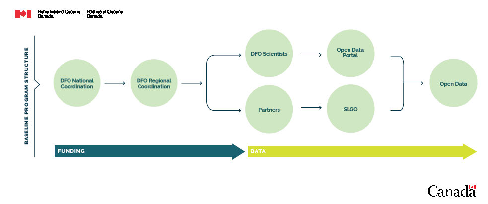
Infographic: Program structure and steps to achieve open data.
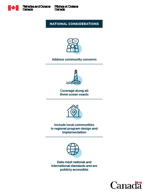
Infographic: National considerations of the program, which are the principles that govern the program.
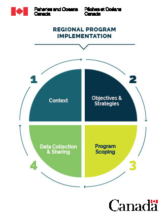
Infographic: The 4 phases of the Regional Program Implementation.
Locations
The first 5 years of the Baseline Program focused on 6 areas of Canada’s coast. These sites were identified as areas of interest due to high or potentially increasing vessel traffic. Many of these areas were lacking baseline environmental data — data needed to help understand the current state of those coastal ecosystems and inform decision making in the future.
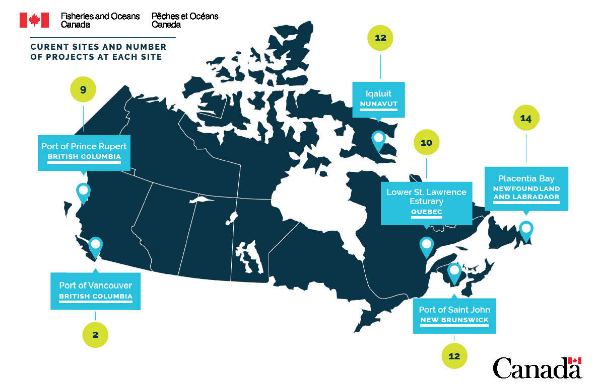
Infographic: Project sites map.
Projects
As of 2022, the Baseline Program has supported 60 projects with 40 different partners (see section on Partners and engagement) across Canada, providing approximately $4.6 million in funding per year across all partner-led projects.
Projects vary in their subject matter, depending on the information needs and the capacity of the partner organizations that designed them. However, projects use sound scientific methods, often coupled with local knowledge, and all projects evaluate some or all of the relevant Target Ecosystem Components which are prioritized by the Baseline Program (see Establishing a baseline section).
Projects involve a variety of activities, including field work, performing laboratory analyses, supporting technical training, supporting student stipends, supporting local employment, purchasing scientific equipment as well as funding outreach and engagement activities.
Partners and engagement
As of 2022, the Baseline Program works with 40 partner organizations across the country, which can be classified in the following general categories:
- academic Institutions
- non-government organizations
- provincial/territorial governments and port authorities
- First Nations organizations
- Inuit organizations
- fisheries organizations
- research centres
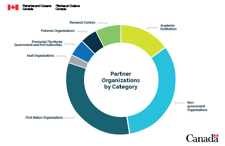
Infographic: Partner organizations by category.
Each group designs and implements Baseline Program scientific projects, which collect important ecological data of interest in their local areas. For a full list of our partners and their projects, visit the project page.
The Baseline Program takes a collaborative approach to partner engagement and priorities are developed in consultation with partners.
The Baseline Program takes a collaborative and responsive approach to partner engagement by developing program priorities in consultation with partners. Potential partners are engaged through the Baseline Program offices and planning workshops in their respective regions of the country. These partner workshops connect local groups interested in collecting baseline information. The workshops also allow key parties to contribute to the development of priorities for data collection at each of the current sites. The data collection priorities are based on local needs and in alignment with our mandate.
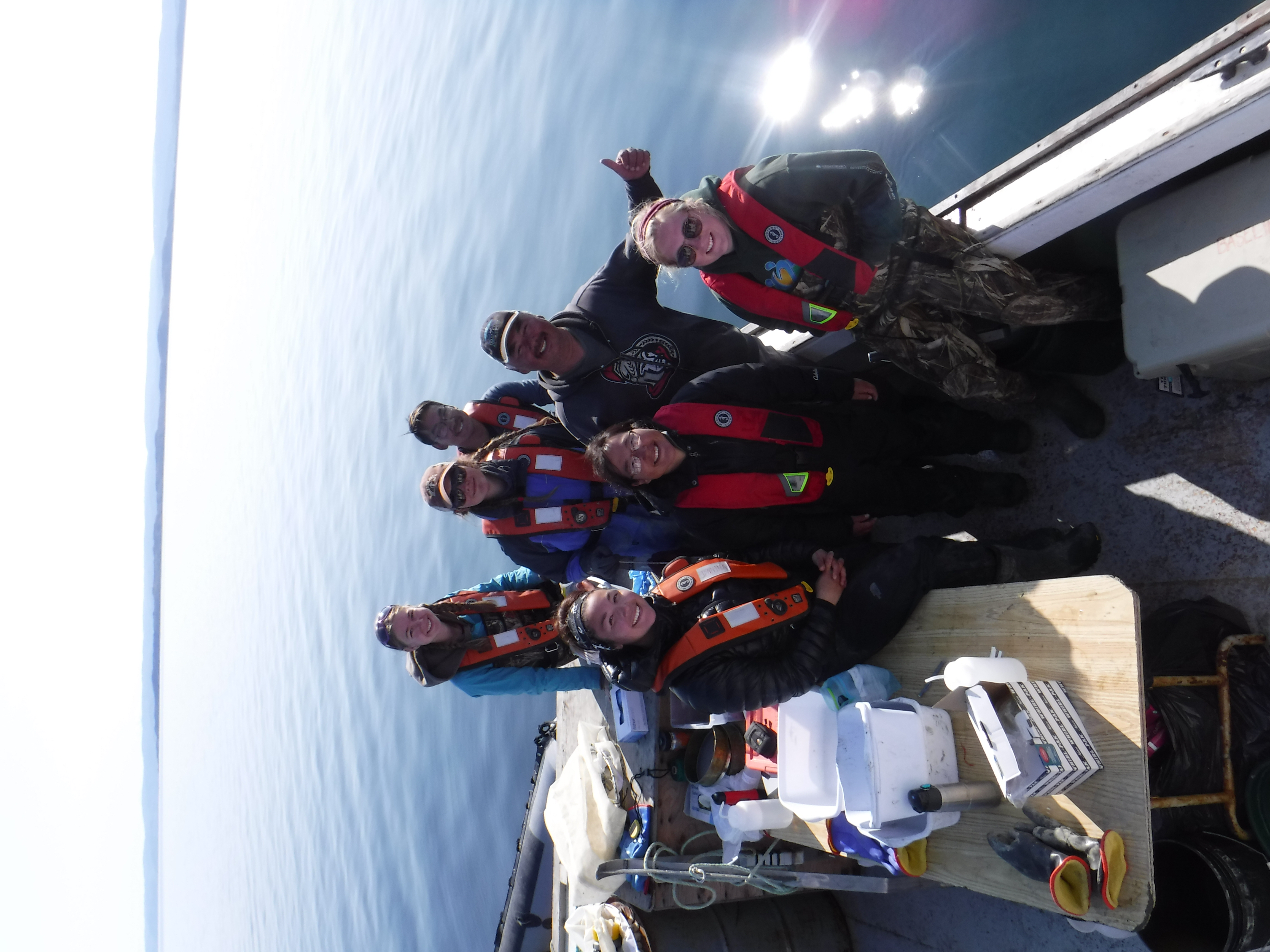
DFO Scientists and Baseline Partners on the water and ready to sample in Iqaluit, Nunavut. Photo: C. Lewis, Fisheries and Oceans Canada.
Important topics that partners engaged on early in the Baseline Program included:
- boundaries of sites
- ecosystem components of interest/concern
- baseline collection strategies
- sampling protocols
- data management and analysis
Subsequent meetings allowed partners to review and amend the list of ecosystem components to be measured and further specify areas of concern and data gaps within each site that key parties were interested in further investigating.
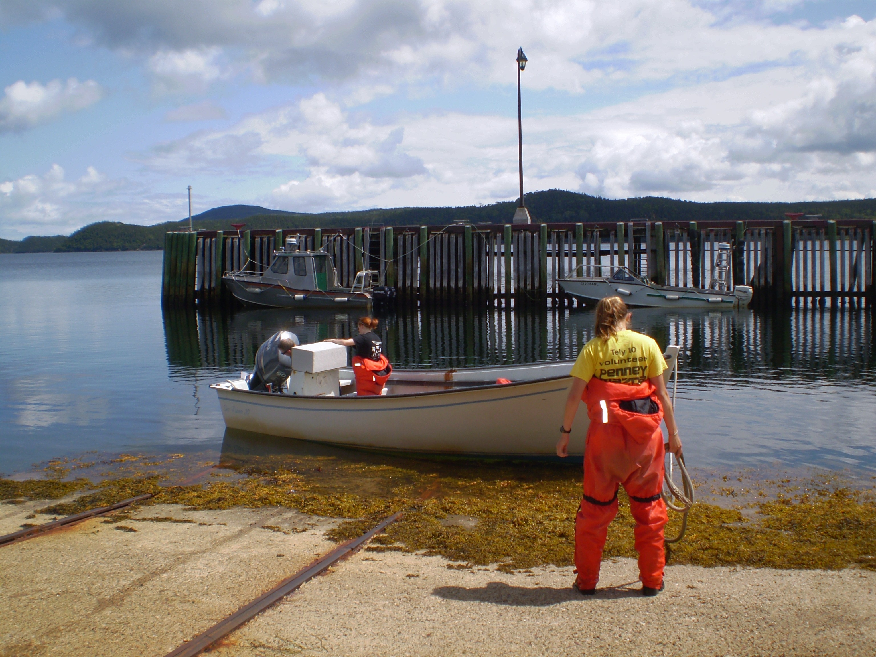
Students setting out for beach seining in Newfoundland. Photo: N. Templeman, Fisheries and Oceans Canada.
Establishing a baseline
The Baseline Program considers a full breadth of physical and biological characteristics to better understand the current state (baseline) of key coastal ecosystems. Below is a description of the approach the program has taken to establish this baseline.
National Target Ecosystem Components
The priority of the Baseline Program is the collection of baseline data relating to key ecosystem characteristics. With this data, scientists are able to maximize their understanding of the ecosystem and how it works. A set of nationally consistent Target Ecosystem Components were identified to be captured in data collection activities. These Target Ecosystem Components were put forward through consultation with regional departmental staff and interested key parties across the country.
These target components are the key physical and biological features needed to establish a baseline for these coastal areas and are also features that partners are most interested in understanding in their local areas.
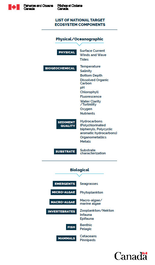
Infographic: List of National Target Ecosystem Components.
Data collection and management
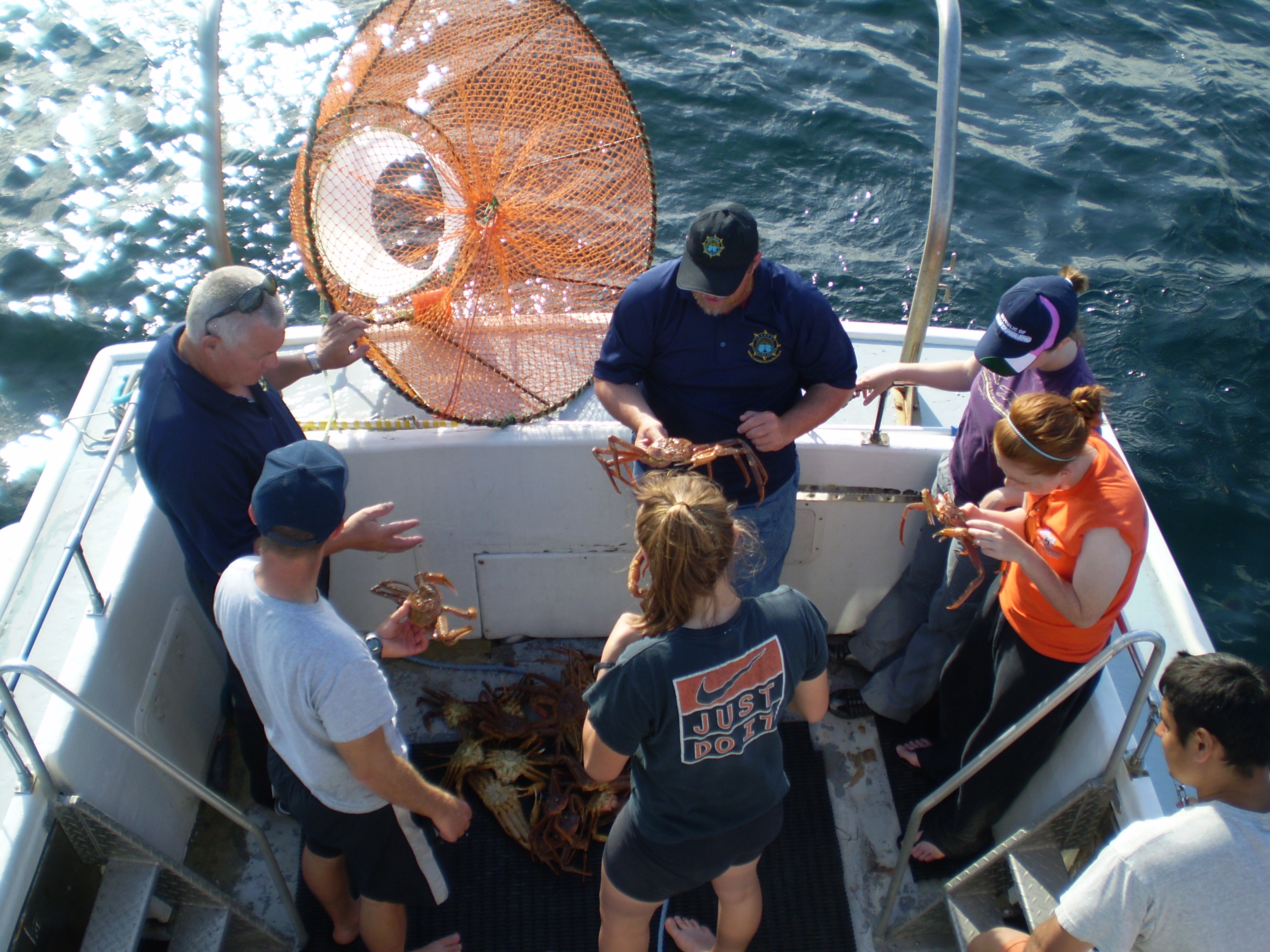
Demonstrating how to catch and sample crabs for baseline data collection in Newfoundland. Photo: N. Templeman, Fisheries and Oceans Canada.
Baseline Program information gathering is based on partner-sourced data collected from 50+ projects at a variety of locations across Canada, including remote areas with limited technological capacity. The data collection is carried out mainly by Indigenous organizations and non-government organizations, both empirically through field and lab activities, as well as through accessing existing open data forums.
The data types collected can range from manual recording of field observations, like intertidal species surveys, to automatic field recording technology, like acoustic monitoring equipment in the water. These data exist in a broad range of formats, including tabular (e.g. integer, descriptive), textual (e.g. PDFs), geospatial, photographic, video and acoustic.
To maximize the accessibility and utility of the data collected by partners through the Baseline Program, the St. Lawrence Global Observatory is currently carrying out a dedicated data management project. The St. Lawrence Global Observatory has developed a catalogue which allows the visualization of metadata and has the capacity for data storage, upload, management and analysis of a broad range of partner datasets. Their online data portal includes easy access to datasets, geospatial information, visualization apps and associated metadata. All data will also be compatible with the FAIR principles for scientific data and other relevant international standards.
This integrated system facilitates the process of making Baseline Program data open and accessible to the public.
Data collected through the Baseline Program will be openly available and compatible with international standards.
For more information on this data project and to see the Baseline Program data that is already accessible, please visit the online data catalogue St. Lawrence Global Observatory – Coastal Environmental Baseline Program Datasets.
Glossary
- Term
- Definition
- Ecosystem services
-
The benefits people get from ecosystems:
- goods, like food, raw materials, plants, animals and micro-organisms
- regulating services, such as pollination of crops, prevention of soil erosion and water purification
- cultural services, like recreation and a sense of place
- Baseline ecological data
- Qualitative and quantitative information on the current status of various characteristics of the ecosystem, which is used as the starting point for measuring future ecosystem change.
- Grants and contribution program
- Government program which transfers funding to eligible recipients for specific research or data collection activities that address specified program priorities. There are various conditions on the funding, such as leveraging requirements.
- Adaptive management
- A systematic approach for improving a program by learning from outcomes and applying changes to future iterations.
- Target Ecosystem Components
- Ecosystem components identified as being critical to understanding and characterizing ecosystems. These include both physical and biological characteristics.
- Open data
- Structured data that is machine-readable, freely shared, used and built on without restrictions. The data must be available to everyone, accessible and re-usable.
- FAIR principles
- The FAIR Guiding Principles for scientific data management and stewardship were published in Scientific Data in 2016. The authors intended to provide guidelines to improve the Findability, Accessibility, Interoperability and Reuse of digital assets – and these guidelines are now widely used as the standard in data management.
Contact us
For more information about the Baseline Program, please contact us at:
Fisheries and Oceans CanadaCommunications Directorate
200 Kent St
Station 13E228
Ottawa ON K1A 0E6 Email: info@dfo-mpo.gc.ca
Teletypewriter: 1-800-465-7735
- Date modified: