
High-Resolution Digital Elevation Models in Intertidal and Shallow Zones
Description
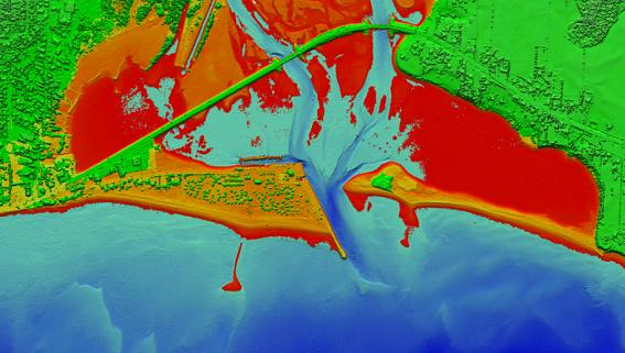
Computer simulations of shoreline characteristics such as coastal erosion, transportation of sediments, and wave action are important for understanding how climate change impacts will affect coastal infrastructure. Without this information, it is impossible to accurately forecast how much damage will occur in zones that are affected by storm surges or properly plan projects designed to protect infrastructure. Until recently, intertidal and shallow zones in Canada were difficult to map, but this project uses current technology to produce high-resolution maps of these complex zones and coastal habitats, providing important information for the development of computer simulations. This approach can also be adapted to other similarly sensitive areas.
Results: Researchers established new ways to publish and share information on complex coastal zones, and demonstrated that it is possible to deliver high-definition coastal maps using a simple web browser. Detailed information, in various formats, has been made available for four areas: Bonaventure, Quebec; Vieux Fort, Quebec; Alexandria Bay, Arctic; and Mahone Bay, Atlantic. The results of this project ensure that valuable data is available to, and used by, the coastal community to inform adaptive measures to climate change.
Program Name
Aquatic Climate Change Adaptation Services Program (ACCASP)
Ecoregion(s)
Atlantic: Gulf of St. Lawrence, St. Lawrence Estuary
Principal Investigator(s)
Louis Maltais
Fisheries and Oceans Canada
- Date modified: