
Tang.ɢ̱wan – ḥačxwiqak – Tsig̱is Marine Protected Area (MPA) annual report 2024
On this page
- At-a-glance
- Conservation objectives
- Management and governance
- Feature creatures
- Research and monitoring
- Collaboration and partnerships
- In the spotlight: benefits
- Surveillance and enforcement
- Outreach and engagement
At-a-glance
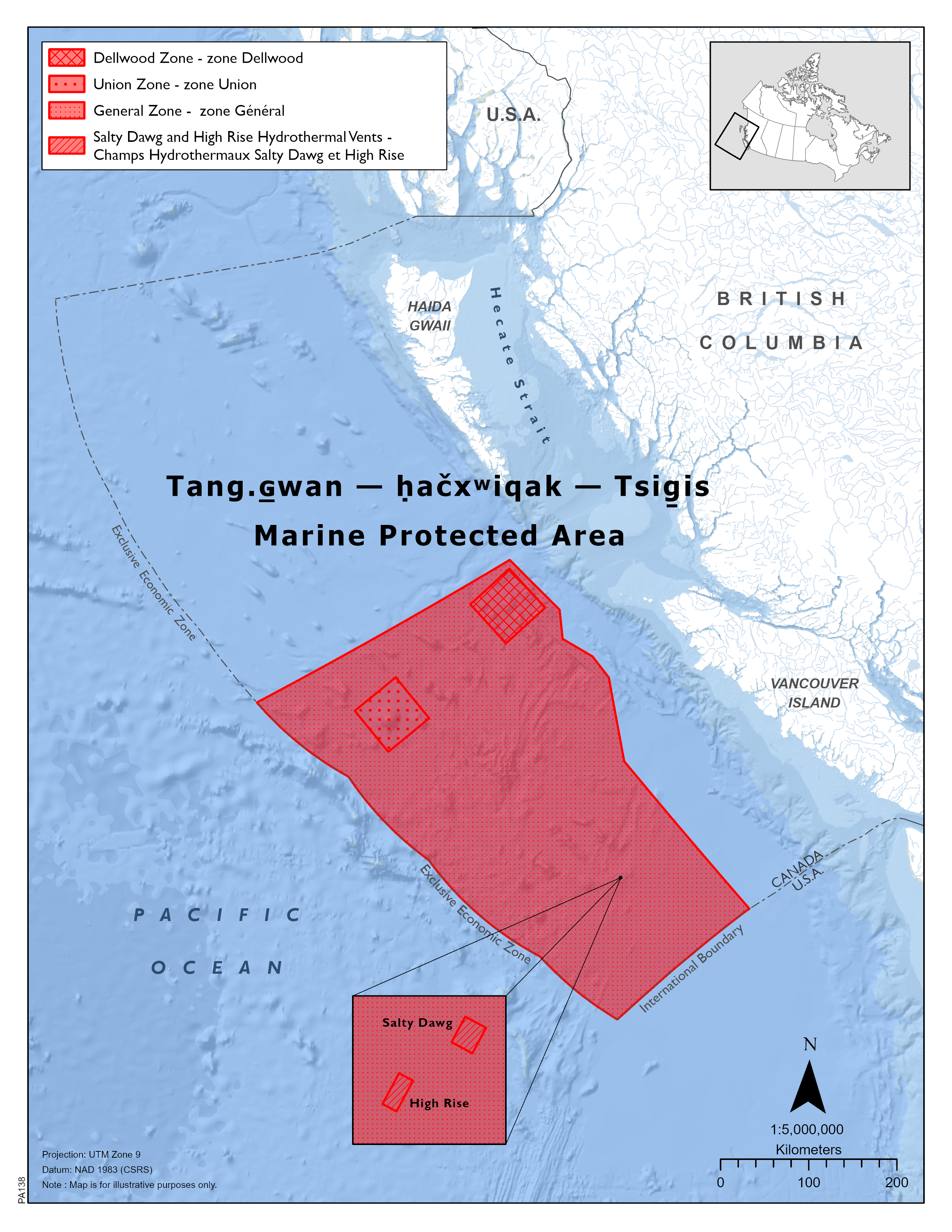
Map of the Tang.ɢ̱wan – ḥačxwiqak – Tsig̱is Marine Protected Area.
Date of designation:
June 19, 2024
Size:
133,017 km2
Contribution towards the marine conservation targets:
2.3%
Location:
This MPA is located on average 150 km from the coast of Vancouver Island, British Columbia in the Offshore Pacific Bioregion.
Co-managed by:
- Nuu-chah-nulth Tribal Council (NTC)
- Council of the Haida Nation (CHN)
- Pacheedaht First Nation (PFN)
- Quatsino First Nation (QFN)
- Fisheries and Oceans Canada (DFO)
Acknowledgement:
First Nation co-management partners have designated or are in the process of designating the MPA under their respective authorities.
Zones:
There are 3 management zones in the MPA:
- Union Zone and Dellwood Zone – Protect the more sensitive Union and Dellwood seamounts and the habitats and species they support. Each seamount has its own management zone that is approximately 3,600 km2in size
- General Zone – It is the remaining area of the MPA not covered by the Union and Dellwood Zones. This area is approximately 125,817 km2in size
Conservation objectives
- Conserve, protect and enhance understanding of unique seafloor features, including seamounts and hydrothermal vents and the marine ecosystems they support in the MPA.
Management and governance
On June 19, 2024, the Endeavour Hydrothermal Vent (EHV) MPA Regulations were repealed with the designation of the Tang.ɢ̱wan – ḥačxwiqak – Tsig̱is MPA (TḥT MPA). The TḥT MPA covers approximately 133, 017 km2 of Canada’s Exclusive Economic Zone and it includes the entire area that was previously protected by the EHV MPA. TḥT is Canada’s largest MPA designated under the Oceans Act via Governor in Council (GiC) regulation.
DFO and its First Nation partners meet monthly during TḥT MPA co-management technical working group meetings. In 2024, this working group met 8 times.
After the MPA was designated in June 2024, Terms of Reference were developed for the MPA’s future Management Board. Work is underway to form the Management Board, after which the Board will begin developing the Management Plan.
In addition to the MPA’s Management Board, an Advisory Committee will be formed upon agreement from all management partners.
Ongoing management activities in 2024 were supported through DFO’s programs, including:
- Oceans Management Contribution Program
- Aboriginal Aquatic Resource and Oceans Management Program
- Aboriginal Fisheries Strategy.
All 4 TḥT First Nation co-management partners (Nuu-chah-nulth Tribal Council, Council of Haida Nation, Pacheedaht First Nation, Quatsino First Nation) have a DFO-funded agreement.
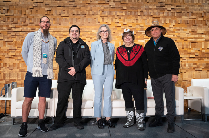
Gaagwiis Jason Alsop, President of the Council of the Haida Nation; James Wallas, Councillor of Quatsino First Nation; Joyce Murray, former Fisheries Minister; Cloy-e-iis, Dr. Judith Sayers, President of the Nuu-chah-nulth Tribal Council; and Jeff Jones, former Chief of Pacheedaht First Nation at IMPAC5 (the 5th International Marine Protected Areas Congress) jointly announcing the Memorandum of Understanding agreement to collaboratively manage Tang.ɢ̱wan – ḥačxwiqak – Tsig̱is MPA.
Feature creatures
“Itchy Shark”
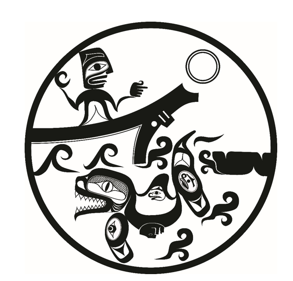
A field note drawing in the style of Nuu-chah-nulth traditional art by expedition member and co-author Hawilh-Wayanis (Joshua Watts) illustrating the 2019 shark encounter. A human figure is depicted aboard a vessel witnessing the Salmon Shark scratching behaviour. The rounded or arched shark represents the frequent circling of the animal back to the log. The shark’s silhouette includes many faces depicting the visible parasitic copepods. The use of a canoe silhouette honours the Nuu-chah-nulth Peoples’ long history as oceanic explorers and fishers. Such Indigenous traditional art is a highly successful way of knowing and sharing ecological knowledge and natural science.
Along the Pacific coast of Canada, Salmon Sharks migrate seasonally with salmon. In 2019 and 2021, scientists from CHN, NTC and DFO were conducting deep-sea research in the then proposed TḥT MPA when the team encountered 2 Salmon Sharks using floating debris to scratch their bodies! In 2019, the Salmon Shark was using a barnacle-encrusted floating log to ‘scratch’ while in 2021 the Salmon Shark was using a piece of floating fibreglass. This was the first time this ‘scratching’ behaviour had ever been documented on anthropogenic debris and the results were published in the Canadian Field Naturalist.
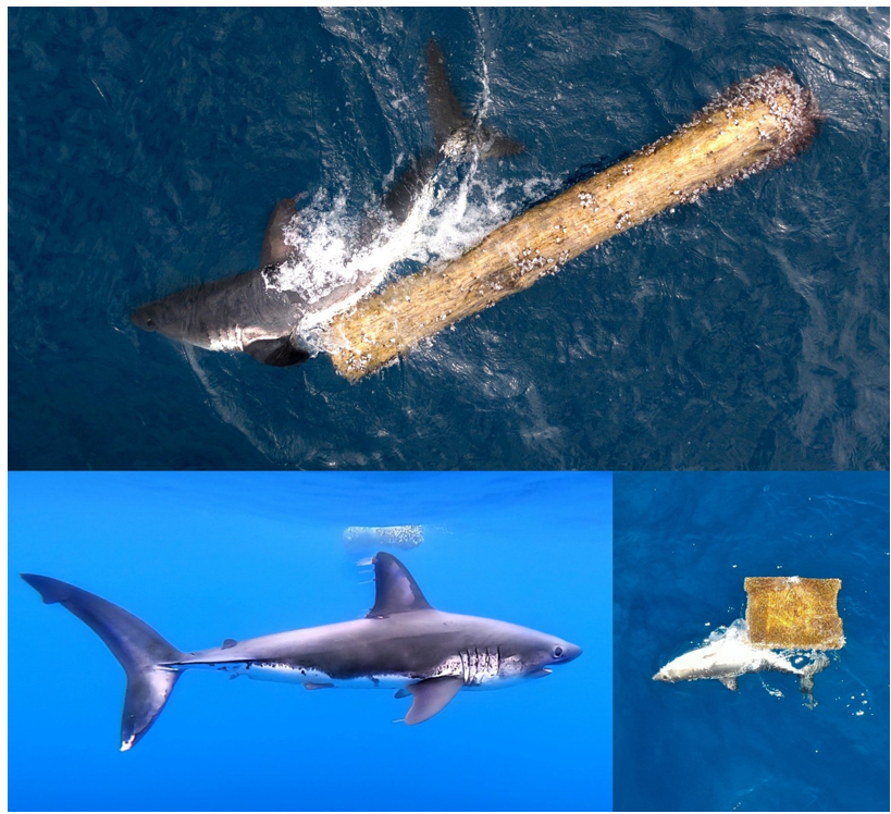
Salmon Shark (Lamna ditropis) scratching behaviour using floating anthropogenic debris in the open ocean of the Northeast Pacific in 2019 (a,b) and in 2021 (c). These images were captured using drones and an underwater camera. (a) Shark using a barnacle-encrusted log. (b) Parasitic copepods on the shark’s fins. (c) Shark using a square of fibreglass. Photo credit: (a) Shelton Du Preez. (b,c) Cherisse Du Preez.
Research and monitoring
The ongoing research and monitoring activities in the TḥT MPA occur primarily through the collaborative NorthEast Pacific Deep Exploration Project (NEPDEP), which is an United Nations Decade of Ocean Science and Challenger 150 endorsed project. NEPDEP is a collaboration of:
- scientists
- communicators
- marine planning professionals from:
- Federal and Indigenous governments
- non-profit institutions
- academia
In 2024, NEPDEP continued to explore and study the TḥT MPA during joint expeditions, as well as plan, design and carry out long-term ecological monitoring studies in the TḥT MPA. While there were no publications pertaining to the research and monitoring of TḥT MPA in 2024, the team had many discoveries that have garnered well-deserved media and will be the basis for future publications, such as:
- discovering nursery grounds
- recording impacts of climate change
- documenting never-before seen animal behaviors
- identifying new species
- locating biodiversity hotspots
- mapping dozens of previously undocumented seamounts
- finding refuges for rare species
To better understand the potential effects of climate change, the NEPDEP team established long-term monitoring sites within the area and in 2024, they were able return to them 5 years later. Using a long-term oceanographic study (Line P) that includes study sites within the TḥT MPA, preliminary results indicate that over the past 60 years the ocean in this area has lost about 15% of its oxygen. In addition, the oxygen minimum zone appears to be getting deeper each year while the calcium carbonate saturation horizon is shoaling. With decreasing oxygen and increasing acidity, the time series data from these sites suggest that substantial impacts of climate change on the fauna of the seamounts within TḥT MPA are likely. For example, between 2018 and 2024, there was an 88% loss in glass sponge abundance at one of the long-term monitoring sites on the Explorer Seamount within the TḥT MPA.
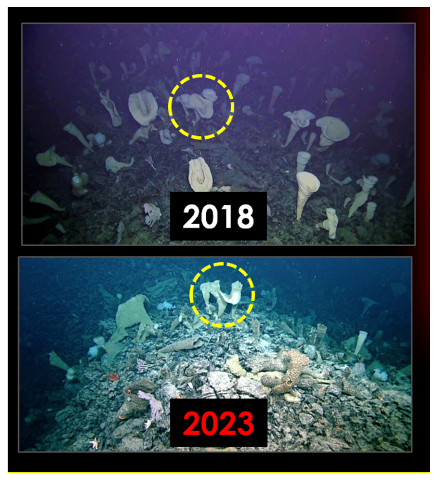
The change in Glass Sponge (Pinulasma sp.) abundance at a long-term monitoring site on Explorer Seamount as observed between years 2018 and 2023. Photo credit: Northeast Pacific Deep-Sea Expedition & Canadian Scientific Submersible Facility Remotely Operated Platform for Ocean Sciences.
Collaboration and partnerships
Several ongoing collaborations and partnerships continued in the area of this MPA in 2024. For example, Oceans Networks Canada (ONC) and DFO collaborated in the development of remote monitoring tools for the Endeavour Hydrothermal Vents within TḥT MPA. Every year, a real-time cabled observatory, NEPTUNE (North-East Pacific Time-Series Underwater Networked Experiments) collects around 100 terabytes of scientific data. This time-series data gathered allows scientists to study long-term changes in support of MPA management and contains information on:
- climate change
- hazard mitigation (earthquakes and tsunamis)
- ocean management
- ocean pollution
- port security and shipping
- resource development
- sovereignty and security
In addition, the collaborative NorthEast Pacific Deep Exploration Project (NEPDEP) continued in 2024, with contributions from:
- DFO
- CHN
- NTC
- ONC
- Royal BC Museum
- University of Victoria
NEPDEP has a mission to discover, explore and monitor life far below the waves for the conservation of these remarkable ecosystems. NEPDEP team members have been working with collaborators at the University of Victoria on the Traitors Project – a trait-based database for all species that inhabit the Offshore Pacific Bioregion with the aim of informing management in conservation areas like the TḥT MPA.
In the spotlight: benefits
Ecological
TḥT MPA is home to remarkably abundant and diverse marine life owing to the unique geology. A network of hydrothermal vents (fountains of superheated and mineral-enriched water) and seamounts (ancient volcanic mountains over 1,000 m tall) shape the seafloor. These biological hotspots enhance ocean productivity and provide:
- habitat
- shelter
- food
- spawning grounds
- nursery areas
Ecological benefits from ecosystem services include food and climate regulation (via soft sediment blue carbon ecosystem). Hydrothermal vent ecosystems also provide other benefits associated with ecosystem services such as ocean chemistry and circulation regulation.
Economic
Soft sediment in TḥT MPA is considered a Blue Carbon Ecosystem. According to research by the University of Victoria, DFO and Oceans North, protecting carbon rich seabed sediments in MPAs could provide climate change mitigation benefits. In addition to potential Blue Carbon Ecosystem benefits, decades of research is another direct economic benefit of the MPA since expeditions to the MPA can benefit the communities where goods and services are accessed, as well as jobs that support scientific expeditions, data collection and analysis.
Socio-cultural
The Indigenous MPA name consists of:
- Tang.ɢ̱wan; a Haida word meaning deep ocean
- ḥačxwiqak; a Nuu-chah-nulth and Pacheedaht word meaning deepest part of the ocean
- Tsig̱is; a Quatsino word referring to a monster of the deep
Council of the Haida Nation partners shared the following:
The Haida portion of the MPA that lies within Haida territory is named “Tang.ɢ̲wan Chaaɢ̲an Daanaay Kuuyada” which means “Precious deep water ocean place”. The CHN designated the portion of the then proposed Tang.ɢwan – ḥačxwiqak – Tsig̱is MPA within Haida Territory as a Haida Heritage Site in October 2022.
The Haida Nation has been protecting coastal waters for millennia, ensuring food security, cultural preservation and Haida management. Our people know that special places exist in the deepest parts of the ocean and we will continue to respect, protect and conserve these habitats. The joint designations demonstrate that all parties share a long-term commitment to ocean protection and biodiversity conservation.
Nuu-chah-nulth Tribal Council partners shared the following:
For millennia, the Nuu-chah-nulth, a Saltwater People have maintained a deep spiritual, cultural and material connection to the ocean. The ocean is at the heart of our way of life—it sustains us and is the foundation of our ability to thrive. Our guiding principle, “hishukish ts'awalk”, reminds us that everything is connected—the deep ocean is tied to the shore and it is our shared responsibility to care for it, a duty referred to as “uu-a-thluk” or “taking care of”.
The joint management of TḥT MPA creates an opportunity for collaborative research, partnership and decision-making between all partners, allowing us to share our deep knowledge and understanding of ocean ecosystems.
Surveillance and enforcement
Due to the offshore location of this MPA, DFO’s Conservation & Protection (C&P) Fishery Officers primarily enforce the Regulations through remote surveillance. Despite the challenging location of the MPA, C&P’s Fisheries Aerial Surveillance and Enforcement (FASE) Program was able to conduct 10 aerial surveillance patrols primarily over the northeast area of the MPA in 2024.
In addition, monitoring efforts have been enhanced by satellite Radar Satellite II (RSII) coverage in domestic waters. Polar Epsilon Operations at MDA Space generate DFO MPA reports with vessel contacts and associations for our Marine Security Operations Center – West (MSOC-W). Analysts at MSOC-W monitor these DFO MPA Reports and analyze the acquisitions and detections with Automatic Identification System (AIS) associations.
In 2024, there were 690 RSII contacts near or inside this MPA and 617 of those were identified by their AIS as fishing vessels. Vessels exhibiting possible fishing behaviour contrary to regulations were triaged for follow-up by a C&P Fishery Officer.
In 2024, there were no fisheries violations detected from audits to electronic monitoring data aboard fishing vessels.
Outreach and engagement
On July 11 2024, a News Release announced the designation of the MPA. This News Release was jointly developed by:
- NTC
- PFN
- CHN
- QFN
- DFO
In 2024, NEPDEP members continued to work together to increase awareness of the TḥT MPA by live-streaming video of their research and by hosting community connections online with the at-sea team during expeditions.
Several videos were created to highlight:
- incredible features in TḥT Marine Protected Area (MPA)
- new discoveries
- new behaviours
- 2024 expedition highlights
NEPDEP members have been sharing the discoveries around the world by participating in conferences like the Ocean Decade Conference and the International Deep-Sea Biology Symposium. NEPDEP stories have reached many forms of media as well with diverse voices telling our diverse stories. For example:
- The underwater mountains that can’t be hiked: Canada’s newest marine protected area
- We’re on a boat (figuratively and literally!) with Dr. Cherisse Du Preez | Ocean Decade Show!
- Gyaahláang Tangée • Kii.ngaay Taang.aay Saltwater News
Related link
- Date modified: