Spotlight on Marine Protected Areas in Canada
The MPA Spotlight report celebrates progress to date in protecting the marine environment through federal, provincial and territorial protected areas in Canada's three oceans and Great Lakes. The report was developed collaboratively, and contains national and regional marine protected area statistics and maps.
SEPTEMBER 2010 UPDATE:
Two new MPAs have been designated since this report was first printed. In June 2010, Gwaii Haanas National Marine Conservation Area Reserve and Haida Heritage Site (3500 km²) in British Columbia was established under the Canada National Marine Conservation Areas Act, and in August 2010, Tarium Niryutait Marine Protected Area (1740 km²) in the Northwest Territories was designated under the Oceans Act. These areas are not included in the statistics of this report.
Table of Contents
- Preface
- Marine Protected Areas in Canada
- Overview of marine protected areas in Canada
- More Information?
- Contact Us
![]()
Spotlight on Marine Protected Areas in Canada (PDF, 2.86 MB)
Frequently Asked Questions
- What definition of marine protected area was used for this report?
- Most of the marine protected areas in the report seem to be terrestrial (coastal). How do they qualify as "marine"?
- How was it determined which coastal areas to include?
- Why were some marine protected areas without IUCN categories included in the report?
- Why were Coral Conservation Areas and other fisheries closures not included in the report, given their conservation value?
- What was the process for collecting and vetting the data?
- How were the Case Studies for the report selected?
![]()
Frequently Asked Questions (PDF, 28.4 KB)
Preface
Canada is a maritime nation. Our oceans and Great Lakes cover an area of approximately 5.7million square kilometres.We have the world's longest coastline, three oceans, the Great Lakes and an immense sea of Arctic ice—all of which support an intricate web of marine life. The Government of Canada, along with the provinces and territories, is working to conserve Canada's marine ecosystems through the development of marine protected areas. Marine protected areas enhance biodiversity and improve the health and sustainable use of our oceans, Great Lakes and coastlines, contributing to the vitality of Canadian coastal communities and industries.
This report highlights marine protected area efforts that have been completed by provincial, territorial and federal agencies in Canada to date. It describes the current status of these efforts, and includes data compiled collaboratively by federal and provincial representatives. The report is not intended to provide a comprehensive study of the management tools available for the protection and conservation of marine life (it does not include fisheries closures, for example), but rather focuses on existing marine protected areas in our three oceans and Great Lakes.
Marine Protected Areas in Canada
Canada's oceans and Great Lakes together have a surface area of approximately 5.7 million square kilometres— an area equivalent to about 56% of Canada's land mass.
What is a marine protected area?
The International Union for Conservation of Nature (IUCN) defines a marine protected area as: "a clearly defined geographical space, recognized, dedicated and managed, through legal or other effective means, to achieve the long-term conservation of nature with associated ecosystem services and cultural values." Some marine protected areas are fully marine, and others are the marine components of terrestrial protected areas.
There are many different types of marine protected areas in Canada.While some are fully protected, most allow multiple uses, or integrate fully protected zones within larger multiple-use areas. Some marine protected areas offer year-round protection while others are seasonal. Seasonal protection is appropriate for spawning or nesting sites or for buffering sensitive areas that may be threatened by human activities at specific times of the year.
Ocean Facts:
- Scientists believe that life appeared in the early oceans 3.5 to 3.7 billion years ago.
- Climate, weather and the quality of the air we breathe depend on interactions between the ocean and the atmosphere.
- Oceans are a primary source of food.
- History illustrates the importance of oceans for trade, commerce, adventure and discovery.
- The majority of the world's human population lives no more than 300 kilometres from the ocean.
- The ocean has shaped our customs, traditions, and fisheries culture.
Why do we need marine protected areas?
Scientists around the world have provided irrefutable evidence that the oceans, in spite of their seemingly healthy appearance, are fragile and at risk. A multitude of cumulative stresses exerted on coastal and ocean regions—from over-fishing to habitat degradation and climate change—means that ecosystem functions are being affected all over the world, including in Canada's oceans and Great Lakes.
Marine protected areas are known to be effective in protecting plants, animals and habitats. They improve the resilience of ecosystems and can have spill-over benefits to areas outside their boundaries. However, in 2007 Canada was ranked only 70th out of 228 countries around the world in establishment of marine protected areas. Despite recent progress in establishing new areas, there is still a significant challenge ahead.
Benefits of marine protected areas to environment, economy and culture
- Marine protected areas play an important role in the local marine ecosystem by increasing biodiversity, restoring community structure, and strengthening ecosystems' abilities to resist, recover from, or adapt to disturbances (such as those caused by overexploitation or climate change).
- Scientific research demonstrates that both tropical and temperate marine protected areas can increase the biodiversity within their boundaries. Certain species benefit from protection in marine protected areas more than others. For example, species that are highly exploited, large-bodied, high in the food chain or sedentary are especially likely to thrive in a marine protected area. Benefits tend to increase over time – especially in temperate waters.
- Marine protected areas can improve the economy of coastal communities by providing conservation and tourism-related employment opportunities. Also, since the creation of marine protected areas can result in increases in the size and abundance of fish, they can create spillover benefits to adjacent fishing grounds. This can translate into fisheries benefits over time including higher catches, increased catch rates and reductions of fishing effort. A marine protected area can thus contribute to the economic and socio-cultural well-being of coastal communities, including supporting subsistence and traditional harvesting of marine resources carried out by Aboriginal peoples.
Marine protected areas and climate change
- Marine protected areas can contribute to climate change mitigation by protecting certain marine habitats that are especially good at absorbing carbon dioxide, emitted to the atmosphere from the burning of fossil fuels, deforestation, and other human activities. For example, coastal habitats such as salt marshes, sea grasses and mangroves account for less than 0.5% of the world's seabed, but studies have shown they can store up to 71% of the total amount of carbon found in ocean sediments. Marine protected areas can also facilitate adaptation to climate change impacts, through protection of ecologically significant habitats (e.g., sources of larval supply), as well as through protection of multiple sites of similar habitat type.
- This increases the likelihood that at least one sample of the habitat type and its associated biodiversity will remain intact, should a catastrophic event occur in the region; thus contributing to the overall resilience (ability to adapt to change) of the marine environment.
Canada's national and international commitments
Canada is committed—both nationally and internationally— to protect its extraordinary marine environments for the benefit of present and future generations. Canada's Oceans Act tasks the Minister of Fisheries and Oceans to lead and coordinate the development and implementation of a national network of marine protected areas on behalf of the Government of Canada. In addition, a global commitment to establish networks of marine protected areas was made at the 2002 World Summit on Sustainable Development, and in the 2004 United Nations Convention on Biological Diversity Program of Work on Protected Areas.
Canada has approximately eight federal and 40 provincial/territorial legislative or regulatory tools for establishing protected areas with a marine component, including those located within the Great Lakes.
Each protected area included in this report is:
- located on the coast or seaward of the coastline;
- consistent with the IUCN definition of a protected area—i.e., a clearly defined geographical space in Canada, recognized, dedicated, and managed, through legal or other effective means, to achieve the long-term conservation of nature with associated ecosystem services and cultural values, that is situated partly or wholly in the marine environment (which includes intertidal or subtidal ocean, saltmarshes, estuaries, Great Lakes or wetlands associated with Great Lakes).
Saltmarshes and estuaries are integrally linked to the ocean environment – their ecology directly impacts the ocean and vice versa – through the transfer of salt water and marine species. Coastal wetlands share similar linkages with the Great Lakes they border.
A range of legislative and regulatory tools exists to establish marine protected areas in Canada, each designed to achieve a particular conservation purpose.
Once a candidate site has been selected for its potential to contribute to a particular conservation goal, consultative and administrative processes are triggered. Cooperation and understanding at the local level are generally fostered through formal or informal consultations and public outreach activities.
Working groups or advisory bodies may be established to develop and assess proposals for candidate sites. Sometimes interjurisdictional agreements are negotiated as part of the process.
As all these steps take time and consultation, it often takes years before a marine protected area is officially established.
Overview of marine protected areas in Canada
In total, existing marine protected areas cover over 56 000 square kilometres of Canada's oceans and Great Lakes—roughly equivalent to the area of Nova Scotia. The breakdown of federal, provincial, and non-governmental agencies responsible for managing these marine protected areas is illustrated on the left, with the total number of marine protected areas managed by each jurisdiction shown in brackets in the legend. Out of the 797 marine protected areas captured in this report, 705 of them are managed provincially, 83 are managed federally, and the remaining nine are managed by either non-governmental organizations or through co-management arrangements. The level of protection provided by different jurisdictions varies, depending on both their mandate and the conservation objective(s) of the site.
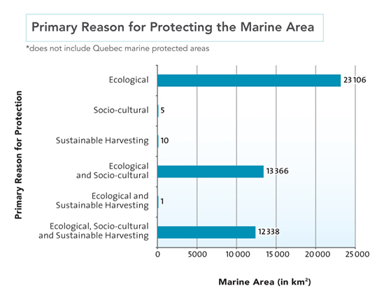
Most of Canada's existing protected marine area is protected for ecological reasons—although in some cases the ecological purpose is combined with sustainable harvesting and/or socio-cultural purposes to reflect multiple priorities. Ecological, socio-cultural, and sustainable use considerations are all very interconnected in oceans management. The health of a marine ecosystem has real impacts on the amount of fish and other resources that can be sustainably harvested from it,which affects local economies and community well-being. Therefore, protecting an area for ecological reasons provides benefits beyond the ecosystem.
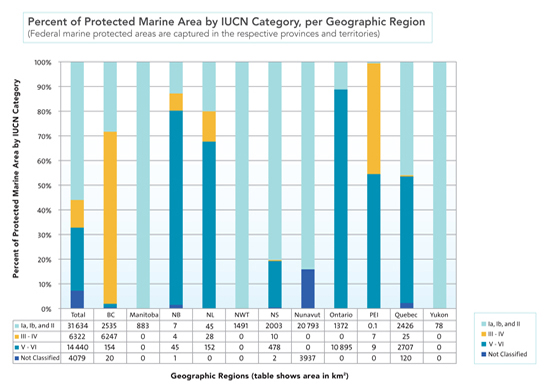
The IUCN has established an international system of categorization for reporting on protected areas (including marine protected areas) at the global level. The categories include protected areas created for: science or as strict nature reserves (Categories Ia and Ib); ecosystem protection and recreation (Category II); outstanding natural features (Category III); particular species and habitats (Category IV); landscapes and seascapes shaped by human interaction (Category V); and protected areas created for sustainable use (Category VI). The categorization is meant to reflect the management approach for a given marine protected area. The most appropriate category depends on an area's specific conservation objectives.
Information compiled about the IUCN categories of Canada's marine protected areas indicates that most of the protected area was 'conserved ecosystems' and 'natural areas' (Categories Ia – II). Each IUCN category provides some type of ecological benefit to Canada's marine environment, although the specific benefits vary.
Now taking a closer look by region...
There are too many marine protected areas in Canada to profile each of them in this report. Instead the following pages will highlight examples of various types of marine protected areas from across the country, designated by different means, and established for a variety of conservation purposes.
Arctic
The Arctic Ocean is a vast region dominated and shaped by the presence of ice, which has a major influence on all biological activity. Much of the Arctic consists of a giant ice cap floating on the ocean in the winter months. Ice conditions along the coastline vary dramatically by season and are also variable and unpredictable from year to year. The Arctic marine environment is fragile, slow to change, and easy to disturb. It is very sensitive to the effects of climate change and human activities. Marine protected areas can play an important role in maintaining this unique ecosystem and traditional ways of life.
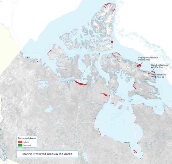
A Case Study: Ninginganiq, Akpait and Qaqulluit National Wildlife Areas
These three National Wildlife Areas on the northeast coast of Baffin Island were identified as part of the Inuit Impact and Benefit Agreement for National Wildlife Areas and Migratory Bird Sanctuaries in the Nunavut Settlement Area. The Agreement is a collaborative effort between the Inuit of the Nunavut Settlement Area and the Government of Canada under the authority of the Nunavut Land Claims Agreement.
As required by these agreements, co-management committees will be established for the National Wildlife Areas to advise the federal Minister of Environment on all aspects of planning and management for the areas. Co-management ensures that both the traditional knowledge and expertise of the Inuit and the best scientific data are combined effectively in all decision-making processes.
Together, the three National Wildlife Areas cover 4534 square kilometres and will provide the opportunity to protect unique and important wildlife species and their habitat, including:
- one of the largest bowhead whale concentrations in Canada, a species of special concern (Ninginganiq National Wildlife Area);
- one of Canada's largest thick-billed murre colonies (Akpait National Wildlife Area); and
- Canada's largest colony of northern fulmars, as well as other marine animals such as walruses and ring seals (Qaqulluit National Wildlife Area).
Pacific
Unlike the Arctic and Atlantic oceans, sea ice is generally absent from the Pacific. This, combined with relatively uniform ocean temperatures and nutrient-rich water flow, results in a high level of biodiversity. Marine invertebrate diversity in the region is particularly rich—some 3800 species— and represents about 3.5% of the world's marine invertebrates. The large invertebrate populations provide a rich food base for fish, marine mammals and other sea life.
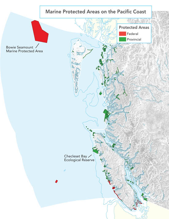
A Case Study: The SG̲áan K̲ínghlas-Bowie Seamount Marine Protected Area
The SG̲áan K̲ínghlas-Bowie Seamount Marine Protected Area encompasses a series of three offshore submarine volcanoes. The Bowie is the shallowest seamount in Canada's Pacific waters and one of Earth's most biologically rich submarine volcanoes. It rises froma depth of 3000 metres to within 24 metres of the surface. It is a rare habitat in the northeast Pacific Ocean, situated about 180 kilometres offshore of Haida Gwaii (the Queen Charlotte Islands).
To the Haida Nation, the indigenous people who live on Haida Gwaii, the submarine volcanoes are known as SG̲áan K̲ínghlas or "supernatural being looking outward". The area has long been recognized by the Haida Nation as a special and protected place.
A Memorandum of Understanding between the Department of Fisheries and Oceans and the Council of the Haida Nation was developed to confirm the commitment to cooperative management and planning of this Oceans Act Marine Protected Area. This demonstrates the shared goal of both parties to protect and conserve SG̲áan K̲ínghlas-Bowie Seamount for present and future generations.
A Case Study: Checleset Bay Ecological Reserve
In the 1960s, a small group of biologists became concerned that the sea otter was disappearing from British Columbia's coasts. In an attempt to save the sea otter, these scientists identified a habitat in Checleset Bay on the west coast of Vancouver Island that would be an ideal site for relocation of the animal. The sea otter was subsequently re-introduced to the area from Alaska in the early 1970s. Not only did the sea otter population flourish, but the kelp/urchin/sea otter ecological relationships that had once characterized the west coast of North America were restored.
The successful relocation effort led the province of British Columbia to establish the Checleset Bay Ecological Reserve. The main purposes of the reserve are to protect and support sea otter ecosystems and provide scientific research opportunities in marine ecology. Much of the reserve is now closed to commercial or recreational harvesting of marine life through complementary fisheries management initiatives.
Atlantic
The richness of the Atlantic Ocean lured early Europeans to settle along its coastline as far back as the 16th century. The Grand Banks, to the east of Newfoundland, are among the most biologically productive marine areas in the world. The confluence of the Labrador Current and the Gulf Stream, together with tidal mixing in the shallow waters of the continental shelf, provide ideal feeding and spawning conditions for a wide variety of species. As one moves east from the vast continental shelf, the Atlantic becomes defined by deep water.
A Case Study: Saguenay–St. Lawrence Marine Park
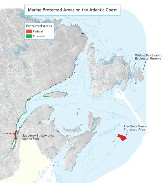
The Saguenay–St. Lawrence Marine Park is a representative example of the exceptional geographical and oceanographic environment at the confluence of the Saguenay Fjord and the St. Lawrence River. It was created to protect a habitat deemed essential to a threatened local population of beluga whales. Jointly established and managed by Canada and Quebec, the 1245 square kilometre marine park was formally established under both federal and provincial legislation in 1998.
This is the first park in Quebec to exclusively protect a marine environment. The Saguenay–St. Lawrence Marine Park is an important habitat for more than 11 species of whales and seals and a variety of seabirds and sea ducks. It has a rich and colourful diversity of marine fish and invertebrates that is enjoyed by kayakers, boaters and divers alike.
A Case Study:Witless Bay Ecological Reserve
The Witless Bay Ecological Reserve includes four islands—Gull, Green, Great and Pee Pee—that teem with life during the seabird breeding season. The islands lie just a few kilometres off the east coast of Newfoundland's Avalon Peninsula. Together they provide breeding habitat for the largest Atlantic puffin colony in North America (>260 000 pairs), the second largest Leach's storm-petrel colony in the world (>600 000 pairs), as well as eight other seabird species. The Reserve also includes a one-kilometremarine zone around the islands, and a two-kilometre corridor between Green Island and Great Island.
The rich diversity of marine life, combined with the offshore islands found in the Witless Bay Ecological Reserve, provide ideal nesting and feeding habitats for seabirds. Capelin, a small smelt-sized schooling fish, forms the backbone of this marine food web. Many species, including cod,whales and seabirds, follow the migration ofmassive schools of capelin on the way to their shallow coastal spawning beaches. The abundance of fish that first attracted Europeans to these coastal waters continues to attract internationally significant populations of whales and seabirds today.
In recognition of the significance and sensitivity of these seabird colonies, the islands were first protected as a Seabird Sanctuary in 1964. The Witless Bay Ecological Reserve was established in 1983 under the provincial Wilderness and Ecological Reserves Act (1983) and Seabird Ecological Reserve Regulations. Regulations govern the operation of boats inside the reserve during the sensitive nesting season from April 1 to September 1; commercial fishing is permitted. A Seabird Ecological Reserve Advisory Committee provides recommendations to the Government of Newfoundland and Labrador onmanagement of Witless Bay Ecological Reserve and other seabird ecological reserves in the provincial protected areas system.
A Case Study: The Gully Marine Protected Area
Canada's Gully is an immense underwater canyon, approximately 200 kilometres off the Nova Scotia coast. It is the largest canyon on the east coast of North America—and so vast and deep that it shapes the ocean currents.
The Gully is one of the most prominent undersea features on the east coast of Canada. This is where the seafloor suddenly drops away into a large and deep submarine valley formed thousands of years ago. More than 65 kilometres long, 15 kilometres wide and two kilometres deep, the Gully's ecosystem includes shallow sandy banks, the deep-water canyon environment, and portions of the continental slope and abyssal plain.
The Gully is recognized around the world as an exceptional environment that provides habitat for a wide range of species. It has significant coral communities, a diversity of both shallow and deep-water fishes, and a variety of whales and dolphins. A resident population of northern bottlenose whales are among the world's deepest divers andmake regular trips to the canyon depths for food.
This Oceans Act Marine Protected Area has three management zones that provide varying levels of protection based on conservation objectives and ecological sensitivities. An ecosystem approach has been applied to the design of the Marine Protected Area so that human activities are assessed against the ecosystem features being protected in the Gully. The regulations also control human activities outside the Gully that could cause harmful effects within the Marine Protected Area boundary.
Fisheries and Oceans Canada works with government partners, industry, non-governmental organizations, the scientific community and other interested groups in the management and conservation of this exceptional marine area.
The Great Lakes
Although the Great Lakes are not marine in the strict sense of the word, they have been described as "freshwater seas" because of their size. At 245 000 square kilometres they are the world's largest freshwater lake system, displaying many of the same attributes as true marine environments. Canada and the United States both have jurisdiction over portions of the Great Lakes, so their respective protected area programs contribute to the overall health of the Great Lakes ecosystems.
A Case Study: The Lake Superior National Marine Conservation Area
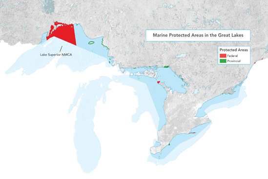
Ontario and Canada agreed to establish the Lake Superior National Marine Conservation Area in October 2007. Located near Thunder Bay, Ontario, it is the world's largest freshwater protected area with a surface area of over 10 000 square kilometres. It covers about one third of the Canadian portion of Lake Superior and extends to the Canada-United States border.
More than 70 species of fish inhabit the near-pristine waters of Lake Superior, the largest of the Great Lakes. Gulls, herons, eagles, and pelicans feed in these waters, and use island habitats for breeding. There are an estimated 50 shipwrecks within the Lake Superior NationalMarine Conservation Area. One of these wrecks, the Gunilda,was described as the most beautiful in the world by Jacques Cousteau. The area boasts many other attractions related to geology, geomorphology, as well as unique flora and fauna. Aboriginal presence in this area dates back at least 5000 years and continues to the present day.
Getting Involved in Protecting Our Oceans
- On June 8, World Oceans Day, celebrate by sharing your passion, discoveries, pictures, research, stories and culture about the oceans with family, friends and children.
- Inform yourself and help others learn about the importance of Canada's oceans.
- Protect sensitive aquatic ecosystems in your area by cleaning up garbage from beaches, streams, rivers or wetlands.
- Use natural pest controls on your lawn or garden. Use biodegradable cleaners for all cleaning jobs. Practice the 3 R's and reduce, re-use, and recycle all your cans, paper, plastic, and glass products – everything flows to the sea!
- When boating or visiting a shoreline, always take all of your waste away with you for proper disposal and recycling.
- Help control the spread of invasive species by cleaning your boats, being diligent about ballast water, and not releasing live bait.
- Keep informed and get involved in local groups and initiatives that help to protect and conserve our oceans and waterways.
- Help fight climate change impacts on the oceans – ride a bike or use public transit and encourage your friends and family to do the same.
All of these actions, however small, can make a difference.
Marine protected areas – the way forward
This report highlights existing marine protected areas, which collectively protect 1% of Canada's oceans and Great Lakes. Many additional sites are currently under study or are in the process of being established, such as the proposed Gwaii Haanas National Marine Conservation Area Reserve and Haida Heritage Site. Progress in recent years can also be measured in terms of initial financial investments; advice acquired from national and international marine protected area practitioners and ecosystem scientists; establishment of processes, partnerships and governance structures; and policy development. With all this in place as a foundation, we are well poised to move ahead with additional marine protected area establishment in Canada.Footnote 1
There is widespread international agreement on the need for networks of marine protected areas to help restore and maintain the health of our oceans. A network is a set of complementary and ecologically linked marine protected areas in a particular region. Effective networks protect examples of ecosystems or habitat types in a region, as well as special or unique areas. Marine protected area networks can contribute to sustainable development goals by fostering integrated ocean and coastal management through three inter-related functions and benefits:
- Ecological – A network can help maintain functional marine ecosystems and their associated biodiversity.
- Social – A network can help resolve and manage conflicts in the use of natural resources, and provide opportunities for research and education.
- Economical – A network can facilitate the efficient use of financial and human resources.
The Government of Canada, in collaboration with provincial and territorial partners, is leading the development and implementation of a national network of marine protected areas for Canada's oceans and Great Lakes. The next report on marine protected areas in Canada will highlight progress made in establishing the network, using the information in this report as the starting point. Network planning will take into consideration the protection provided by other management tools not covered here, such as certain fisheries closures. It will be situated within Canada's integrated approach to oceans management, for the long-term health of our marine environment and all that depends upon it.
More Information?
Find out more about marine protected areas by visiting the following websites:
- Canadian Council on Ecological Areas' Conservation Areas Reporting and Tracking System(CARTS): http://www.ccea.org/carts/
- Protecting fragile marine areas and species on the ocean bottom
- Stay tuned: an online interactive mapping tool for marine protected areas in Canada is currently under development...
In Memory of Dr. Jon Lien
This report honours the contributions of the late Dr. Jon Lien, one of Canada's foremost advocates of marine conservation. As a professor at Memorial University, he earned international recognition for his extensive research on whales of the Newfoundland and Labrador region. Dr. Lien was particularly well known for his work with fishermen to free whales that had become trapped in fishing gear. He was also instrumental in helping to establish the Eastport Marine Protected Area in Bonavista Bay. A recipient of the Order of Canada and the Order of Newfoundland and Labrador, Dr. Lien's passion for and commitment to the marine world were infectious and influenced many of his students and associates to join him in his chosen field.
Contact Us
Telephone: 1-833-212-1438
Fax: (613) 990-1866
TTY: 1 (800) 465-7735
Regular mail:
Fisheries and Oceans Canada
Communications Branch
200 Kent Street
13th Floor, Station 13E228
Ottawa, Ontario K1A 0E6
Canada
Email:
info@dfo-mpo.gc.ca (please include your postal code and email address)
Or visit our Web site at
This report may be cited as:
Government of Canada. 2010.
Spotlight on Marine Protected Areas in Canada.
Fisheries and Oceans Canada. Ottawa. 24 pp
Frequently Asked Questions Regarding the Spotlight on Marine Protected Areas in Canada Report
1. What definition of marine protected area was used for this report?
Answer:
The report defines marine protected areas (MPAs) as: "a clearly defined geographical space in Canada, recognized, dedicated, and managed, through legal or other effective means, to achieve the long-term conservation of nature with associated ecosystem services and cultural values, that is situated partly or wholly in the marine environment (which includes inter-tidal or sub-tidal ocean, salt marshes, estuaries, Great Lakes or wetlands associated with Great Lakes)". The definition is based on the internationally-recognized IUCN definition of a protected area, but made more specific to a marine environment.
2. Most of the marine protected areas in the report seem to be terrestrial (coastal). How do they qualify as "marine"?
Answer:
The marine protected area definition used in the Spotlight report allows for the inclusion of the marine component of terrestrial protected areas, which includes stretches of coastline, estuaries, inter-tidal areas, etc. All statistics in the report are based solely on the marine portions of the protected areas; terrestrial portions were excluded. In many cases the marine component is just a small strip of a much larger terrestrial protected area. This is evident from the maps, which only show the marine components.
3. How was it determined which coastal areas to include?
Answer:
All the federal, provincial and territorial jurisdictions with authority to establish protected areas submitted their information for the report, following the same set of rules (criteria). Only coastal areas that include an inter-tidal area, salt marsh, estuary, Great Lake, or coastal wetland (associated with a Great Lake) were included in the Spotlight report. A 1:50 000 scale mapped coastline was applied to standardize the split between coastal (marine) and terrestrial portions of protected areas, except in cases where a higher-resolution boundary was provided by the jurisdictions.
4. Why were some marine protected areas without IUCN categories included in the report?
Answer:
All sites included in this report had to either have an IUCN category assigned to them, or be eligible for IUCN categorization, even if the category had not been determined yet. The marine protected areas described as "not classified" in the report fall into the latter category. Sites that did not satisfy the IUCN definition of a protected area and were ineligible for IUCN categorization were not included in the report.
5. Why were Coral Conservation Areas and other fisheries closures not included in the report, given their conservation value?
Answer:
The potential for management measures such as Coral Conservation Areas, sponge-reef closures and other fisheries closures to contribute to marine conservation is well recognized. Many of these closures meet the definition of a marine protected area and will have a role in achieving objectives of marine protected area networks, once network planning gets underway. At this point in time, Fisheries and Oceans Canada is still in the process of evaluating hundreds of fisheries closures against a set of specific criteria for conservation value. Future reports of marine protected areas and MPA networks in Canada will most certainly include such measures.
6. What was the process for collecting and vetting the data?
Answer:
The data for this report was submitted by federal-provincial-territorial government agencies in the summer of 2009, for the purpose of building a national inventory of current marine protected areas in Canada. In future the MPA inventory will form part of the Canadian Council on Ecological Areas' Conservation Areas Reporting and Tracking System (CARTS), to create one central database for all marine protected areas in Canada. The data in the inventory has been vetted by jurisdictional representatives to ensure it is complete and accurate. The statistics, graphics and maps in the Spotlight report were produced using this data, and were reviewed by the jurisdictional representatives prior to publication.
7. How were the Case Studies for the report selected?
Answer:
Suggestions for case studies were solicited from operational staff of the federal-provincial-territorial government agencies participating in preparation of the report. Selection of case studies was based on two main criteria: achieving balanced representation of federal and provincial/territorial protected area authorities; and obtaining good geographical coverage. Since provincial/territorial areas were predominantly coastal, federal sites were selected to feature the offshore and the Great Lakes-St. Lawrence water system. Although only a limited number of areas could be featured in the report, the public will soon have access to an interactive web-based search tool to learn about any and all of Canada's marine protected areas. Even listing all the 797 marine protected areas in the report would have added another 15 pages to the length of the document.
- Date modified:


