
Coral and sponge conservation measures in the Estuary and Gulf of St. Lawrence
On this page
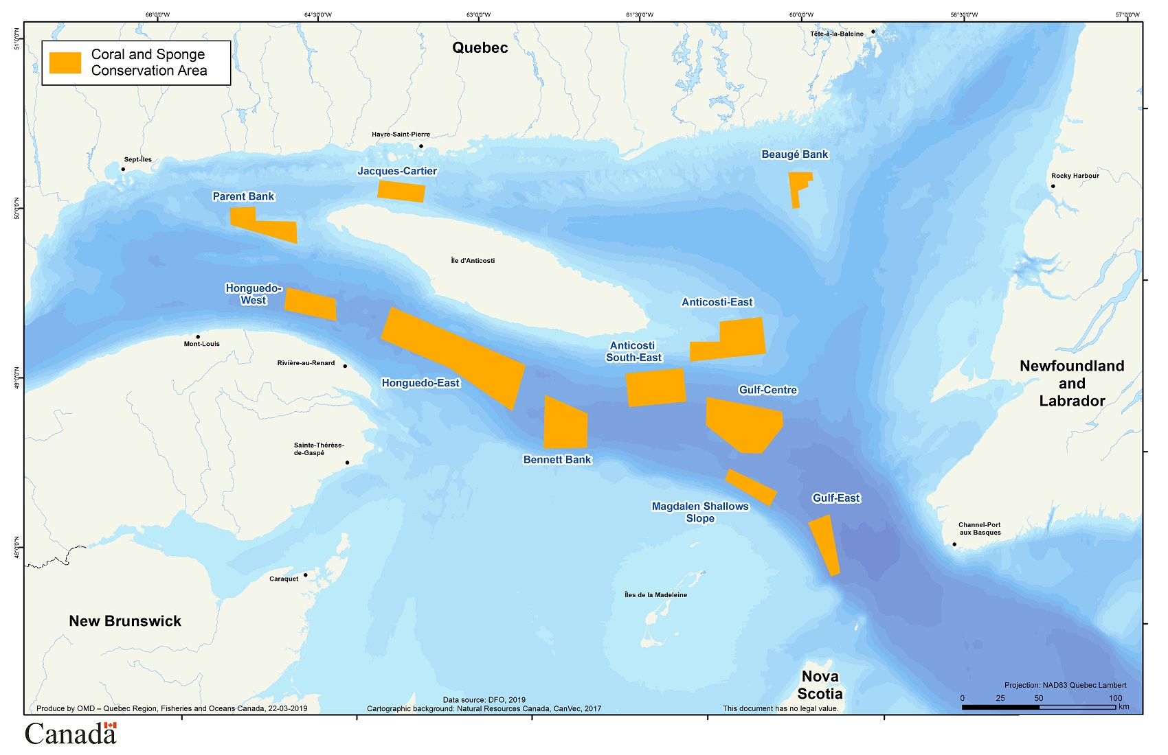
Map: The 11 coral and sponge conservation areas in the Estuary and Gulf of St. Lawrence
Management and conservation
Since December 15, 2017, fisheries management measures have been in place in 11 coral and sponge conservation areas in the Estuary and Gulf of St. Lawrence following the publication of Variation Order 2017-Q-104.
| # | Coral and sponge conservation areas |
|---|---|
| 1 | Parent Bank |
| 2 | West Honguedo |
| 3 | East Honguedo |
| 4 | Bennett Bank |
| 5 | Southeast Anticosti |
| 6 | East Anticosti |
| 7 | Jacques-Cartier |
| 8 | Eastern Gulf |
| 9 | Slope of Magdalen Shallows |
| 10 | Beaugé Bank |
| 11 | Central Gulf |

Video: Corals and Sponges in the Gulf of St. Lawrence.

Video: Coral and sponge marine refuges in the Gulf of St. Lawrence
To encourage conservation, the use of all bottom-contact fishing gear is prohibited in these areas, including, but not limited to, bottom trawls, dredges, gillnets, bottom longlines, bottom seines and traps. The use of this gear is known to pose a risk to important benthic communities, especially corals and sponges in eastern Canada.
Note:
Following the signing of the Canada–Quebec Collaborative Agreement to Establish a Network of Marine Protected Areas in Quebec in March 2018 (available in French), the governments of Canada and Quebec are evaluating the possibility of reinforcing coral and sponge conservation measures in the Gulf of St. Lawrence by prohibiting certain activities other than fishing in certain zones.
Learn more about the Northern Gulf of St. Lawrence marine protected area project.
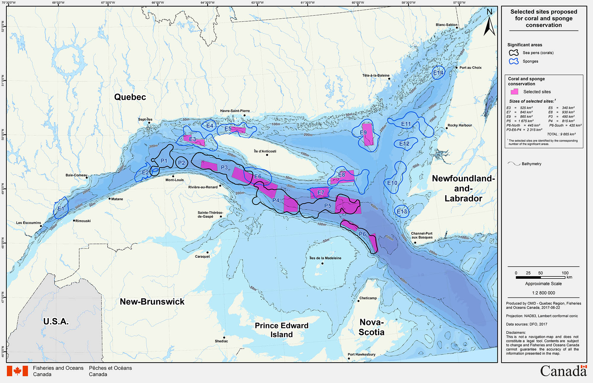
Identification of areas for protection
The process that led to identification of these areas consisted of four stages:
- A consultation carried out with Aboriginal groups and fishers' associations
- An analysis of the comments gathered and economic and biological data
- An initial proposal of sites for implementation of conservation measures, published in June 2017
- An analysis of the comments and information received following publication of the proposal in June 2017
Among the 20 important coral and sponge concentration areas examined, 11 were chosen for conservation. In identifying the conservation areas to be established, Fisheries and Oceans Canada made significant efforts to minimize the impact of these new measures on concerned Aboriginal groups and all stakeholders in the harvesting sector. The maps presenting the selected conservation areas, as well as maps of these areas superimposed on the geographic distribution of annual landed values, are available below.
- Consultation guide for implementing coral and sponge conservation measures in the Gulf of the St. Lawrence (2016 – 2017)
- Questionnaire : Consultation for the establishment of conservation measures for corals and sponges of the Estuary and the Gulf of St. Lawrence (2016 – 2017)
- Initial proposal of sites for implementation of conservation measures (June 2017)
Publications

Postcard and poster
- Gulf of St. Lawrence Coral and Sponge Marine Refuges postcard
- Gulf of St. Lawrence Coral and Sponge Marine Refuges poster
Maps
All areas identified for coral and sponge conservation in the St. Lawrence
- Parent Bank Sponge Conservation Area (Parent Bank)
- Western Honguedo Strait Coral Conservation Area (West Honguedo)
- Eastern Honguedo Strait Coral and Sponge Conservation Area (East Honguedo)
- North of Bennett Bank Coral Conservation Area (Bennett Bank)
- Sponge Conservation Area Southeast of Anticosti Island (Southeast Anticosti)
- Sponge Conservation Area East of Anticosti Island (East Anticosti)
- Jacques-Cartier Strait Sponge Conservation Area (Jacques-Cartier)
- Eastern Gulf of St. Lawrence Coral Conservation Area (Eastern Gulf)
- Slope of Magdalen Shallows Coral Conservation Area (Slope of Magdalen Shallows)
- Beaugé Bank Sponge Conservation Area (Beaugé Bank)
- Central Gulf of St. Lawrence Coral Conservation Area (Central Gulf)
Geographic distribution of the average annual landed value ($) for all fisheries in the Estuary and Gulf of St. Lawrence (2008 – 2015)
(Note that this map includes the historical average landed value of redfish and cod between 1986 and 2015).
Geographic distribution of the average annual landed value ($) for each species listed below:
- Snow crab (2008 – 2015)
- Shrimp (2008 – 2015)
- Greenland halibut (2008 – 2015)
- Atlantic halibut (2008 – 2015)
- Lobster (2008 – 2015)
- Cod (1986 – 2015)
- Redfish (1986 – 2015)
Related links
- Coral & Sponge Conservation Strategy for Eastern Canada (2015)
- Delineation of Coral and Sponge Significant Benthic Areas in Eastern Canada Using Kernel Density Analyses and Species Distribution Models (CSAS ResDocs - 2016/093)
- Delineation of Significant Areas of Coldwater Corals and Sponge-Dominated Communities in Canada's Atlantic and Eastern Arctic Marine Waters and their Overlap with Fishing Activity (CSAS SAR - 2017/007)
- Ecological Risk Assessment Framework (ERAF) for Coldwater Corals and Sponge Dominated Communities: Sustainable Fisheries Framework
- Atlas of Sponges from the Estuary and Northern Gulf of St. Lawrence Multidisciplinary Trawl Survey in 2006-2017 (PDF, 59 MB, 2020)
- Sponges of the Gulf of St. Lawrence: Field and Laboratory Guide (PDF, 51 MB, 2020)
- Date modified: