
Southampton Island area of interest (AOI): Inuit Qaujimajatuqangit workshop report and broader community validation
On this page
- Background
- About the project
- Workshop format
- Common themes about species
- Species
- Habitat and specific areas
- Season and migrations
- Priorities and Inuit uses
- Current and potential future activities and Inuit uses
- Boundary
- Conclusions
- Appendixes
- Glossary of Inuktitut terms
- Contact us
Long description :
...
Background
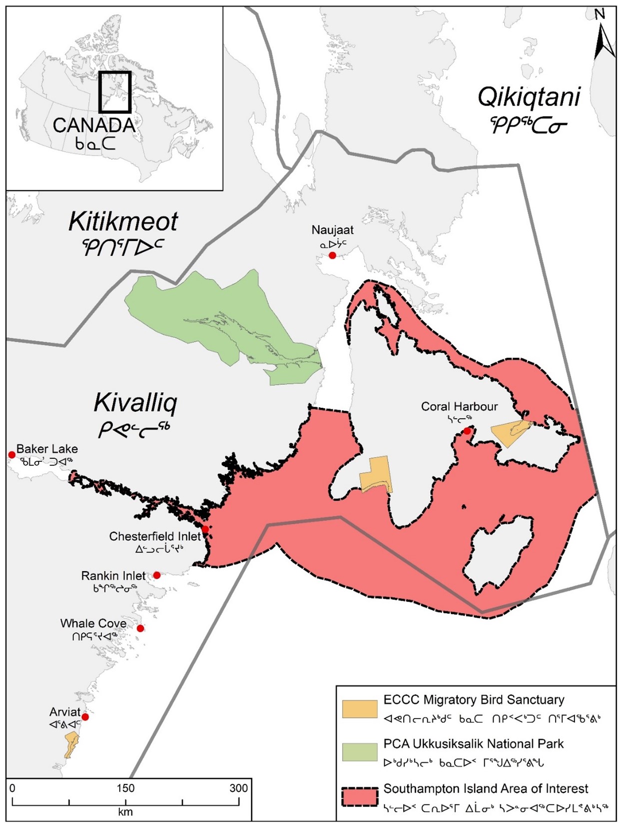
In August 2019, a marine area around Southampton Island (SI) and Chesterfield Inlet (CI) was announced as an AOI for potential Marine Protected Area (MPA) designation under the Oceans Act.
The AOI is in the Kivalliq Region of Nunavut and is adjacent to the coastal communities of Coral Harbour (CH) and CI.
Indigenous traditional ecological knowledge and local use information is required as part of the assessment stage of the MPA establishment process for the SI AOI. Fisheries and Oceans Canada (DFO) commissioned an Inuit Qaujimajatuqangit (IQ) workshop to help characterize the importance of the area to Inuit.
Aqigiq Hunters and Trappers Organization (HTO) of CI and Aiviit HTO of CH each nominated 5 knowledge holders to participate in the IQ workshop, and members of the SI AOI Co-development Committee also participated.
The Co-development Committee has representation from DFO, KIA, Government of Nunavut, and communities of CH and CI and provides advisory input on the AOI development.
This report includes the work leading up to and including the IQ workshop held on February 25 to 26, 2020 in Rankin Inlet (RI), Nunavut. This report summarizes what was heard during the 2-day workshop in relation to species, habitat, migration, seasons and Inuit uses in the AOI around SI and CI. The report concludes with a preliminary synthesis of ideas that was shared and verified during the workshop, concerning priorities for protection, current and potential future activities, and boundary of an MPA.
NVision Insight Group (NVision) was contracted to facilitate the IQ workshop and to produce a report from the workshop. NVision started preparing for this IQ workshop in the 3rd week of January 2020. Once the contract was signed, Lori Idlout met with DFO staff in Iqaluit, Nunavut to begin planning the IQ Workshop to be held in RI.
NVision provided initial drafts of the agenda, questionnaire and consent forms to DFO. Final versions of these documents (Appendices 1, 2 and 3) were distributed to IQ workshop participants on February 20, 2020. The questionnaire was intended to guide discussion at the workshop. It was provided to participants ahead of time, but there was not an expectation that people would fill it out individually.
DFO arranged for simultaneous English/Inuktitut interpretation and location of workshop and coordinated with the local HTOs in selecting workshop participants. All written materials were provided in English and Inuktitut. Fifteen signed consent forms were obtained from the participants. All participants agreed that they had been fully informed of the objectives of the workshop and consented to participating in the workshop for the project, all but one participant agreed to attribution. All participants consented to being photographed and 4 participants did not want recordings attributed to them.
Documentation of knowledge from CH and CI has previously been completed during various projects and assessments. Maps were produced and provided by DFO using previously represented knowledge (see Appendix 4 for detailed methodology). The maps displayed digitized place-based knowledge of species use and distributions, such as:
- aquatic plant
- Arctic char
- Beluga
- Bowhead
- Caribou
- fish
- invertebrate
- Narwhal
- Polar bear
- seal
- Bearded seal
- Ringed seal
- Walrus and Waterfowl
They also displayed activities, such as:
- travel routes
- Inuit harvesting areas
- Inuit campsites
Poster size copies of the Inuit Heritage Trust maps of CH and CI areas, showing traditional place names, were also on hand at the workshop. Base maps showing the AOI boundary were also used by participants at the workshop to provide context and information.
Following the IQ workshop and production of the workshop report (Idlout 2020), the SI AOI Co-development Committee recommended that the IQ workshop report be taken to communities to provide an opportunity for input (what could be added to the report, any suggestions to bring up) before finalizing the report. Accordingly, DFO, the Kivalliq Inuit Association and the Government of Nunavut met face to face with the HTO and Hamlet Council, and held a public meeting and a radio call-in session, in Chesterfield Inlet in March 2021 and in Coral Harbour in June 2023.
DFO produced an addendum to the IQ workshop report documenting the broader community validation in each community. These addenda are found at the end of this report. Furthermore, the shaded areas below highlight the broader community validation in the workshop report. This allows it to be included while keeping the knowledge that was shared at the IQ workshop intact.
Where text boxes appear in this report, for further details please see Addenda: Follow-up broader community validation in Chesterfield Inlet and Coral Harbour.
This report, excepting the addenda and text boxes, has as its basis the Idlout 2020 IQ workshop report produced by NVision Insight Group.
About the project
The purpose of the IQ workshop was to engage with and document IQ on the SI AOI, which will be used to inform the AOI development and MPA establishment process. The objectives set for the workshop were:
- confirm what is known
- filling knowledge gaps
- feedback for next phase
There were 5 participants from CI, 8 from CH and 1 each from the Government of Nunavut and the Kivalliq Inuit Association (KIA). Knowledge holders included both men and women, and youth as well as elders. The participants were:
- CI: Leo Mimialik, Leonie Mimialik, Joseph Nipi Alogut, Jocelyn Simik and Beverly Aggark
- CH: Ross Eetuk, Darryl Nakoolak, Bobbie Saviakjuk, Ayowna Emiktowt, Gordon Nakoolak, Moses Nakoolak, Darcy Nakoolak and a participant who declined attribution
- Government of Nunavut: Tommy Bruce
- KIA: Michael Tucktoo
- DFO staff at the workshop were Charlotte Sharkey and Usaaraq Jari Aariak (Marine Planning and Conservation) and Claire Hornby (Science).
- Lori Idlout from NVision facilitated the workshop.
- Mary Rose Angoshadluk provided English/Inuktitut interpretation.
Workshop format
Charlotte Sharkey informed the participants about MPAs and provided background on the current status of the SI AOI using a PowerPoint presentation.
Once the presentation was completed, the workshop proceeded to 3 breakout groups and the agenda item of confirming ‘what is known’ and ‘filling knowledge gaps’ about SI and CI began. The workshop was guided by the questionnaire and maps that were provided to the participants in that morning. The 3 groups remained in each group for each breakout session. Each group would select a participant to report back the results of each discussion to the larger group.
- Group 1: Leonie, Leo, Darryl, Darcy, Tommy
- Group 2: Bobbi, Moses, Mrs. Emiktowt, Ross, Michael
- Group 3: Claire, Nipi, Jocelyn, Beverly, Gordon and a participant who declined attribution
Participants were not asked to critique the knowledge represented on the maps; rather, the maps were available as a resource to help guide discussion and each group added new information to enhance knowledge of the AOI. The interaction with IQ was categorized into the following categories:
- species
- habitat and specific areas
- seasons and migrations
Common themes about species
Themes that emerged were seen in responses to :
- Question 3: What activities might be affecting the species?
- Question 4: What is it about these activities that may cause an impact?
- Question 6 When is the species most vulnerable?
Shipping
Much was shared about the concerns affecting each species. Although there was variation in responses, shipping was a frequent concern in all areas. The different types of ships included:
- mining ships
- cruise ships
- research vessels including instruments used by researchers
- outfitters (more outboard motors)
- tankers (issues with emptying fuel lines in the water)
- icebreakers
Towards the end of the workshop there was a discussion on the terms ‘vessels’ and ‘ships’ and it was conclued that these terms should be clearly defined for future conversations.
The concerns related to shipping included:
- disturbance and noise pollution, such as icebreakers driving marine mammals away
- frequency of traffic: non-stop and it goes on for 24 hours a day, 7 days a week
- shipping routes displace haul-out sites for walrus and affect behaviour of beluga whales (pushing them into shore), and impact feeding and foraging in deep waters
- causing groups of whales to separate from each other, as larger groups of whales are less vulnerable
Chesterfield Inlet and Coral Harbour Follow-up broader community validation
Shipping is a major concern shared by the residents of Chesterfield Inlet and Coral Harbour. It is harming marine life (walrus, beluga, Arctic char, etc.) and scaring animals farther away from communities. Ocean noise is a major concern. Shipping is recognized as important for the communities and the mines. Some residents of Chesterfield Inlet suggested shipping be paused for 2 weeks in the fall so Arctic char can swim up river undisturbed.
Climate change and waste
In regard to climate change, a group mentioned that climate change seems to have made migration more erratic. There were concerns surrounding seabird nesting, and an observation that smaller birds are not seen as often as before and species normally not seen in the Arctic are being seen (such as the bald eagles and the salmon caught in CH). In regard to waste, there were comments that plastic waste having an impact on wildlife.
Chesterfield Inlet and Coral Harbour Follow-up broader community validation
Fuel discharge/spills, waste and ballast water release are all concerns people in Chesterfield Inlet and Coral Harbour share. It was stated that freeze up is getting later, not earlier. Pollution is harming animals, and mining companies should take more responsibility. Inuit will be the ones left to live with the consequences. Pollution from ships is negatively effecting the quality of marine mammals’ flesh and skins.
Predators and disease
Many responses included that predation was impacting species, specifically, polar bears. A group mentioned that the polar bear quota system has resulted in an increase in the population. The increase in polar bears has resulted in a decrease of the seal population.
Another more recent predator mentioned was killer whales. Other predators mentioned were fox, wolf, and seagulls (bringing avian cholera). Another concern mentioned was that eggs are being over harvested (by people, polar bears and foxes).
Chesterfield Inlet Follow-up broader community validation
Wolverine should be included as a predator.
When species are most vulnerable
Although most responses can be viewed as species specific, they appear to be closely linked to each other. Many participants mentioned that the summer season, when ships and vessels are operating, is when all species are most vulnerable.
Beluga are most vulnerable when they are wounded (naturally or from hunters) and when they are raising young. A question was raised on whether early ocean freeze up is evidence of climate change. Beluga may be affected by these changes, as they may get entrapped in the ice when they have not migrated in time.
Seabirds were considered most vulnerable when they have laid eggs and when the eggs have hatched. Predators, such as polar bears and foxes, enhance this vulnerability.
Research
Generally, more research was requested at various points throughout the workshop. A group mentioned that there needs to be more research on the effect of climate change on migration of different species.
Specifically, research in seal denning and mortality rates, as seals were considered to be more vulnerable now. More seal pup research is required because of the diverse set of predators, such as wolverine and other land predators. One group mentioned that there needs to be a better understanding of the seal population, size and trends (increasing or decreasing).
Groups also requested trichinosis testing be conducted in the Kivalliq and in the alternative, in Nunavut.
A group requested more research on Arctic char, as they do not know much about them.
Chesterfield Inlet and Coral Harbour Follow-up Broader Community Validation
More research was requested specifically on Arctic char, water quality, and the marine mammals (especially walrus) in the AOI. Interest was also expressed in having current scientific information on animals in the AOI shared in communities more.
Species
During the workshop, participants were invited to share knowledge about any species they wished. The following species, selected based on interests and concerns previously voiced by the communities, were inquired about as part of the questionnaire:
- Walrus
- Arctic char
- Beluga
- seals (harp, harbour, ringed, and bearded)
- seabirds
For each of the species the following questions were asked:
- When does the species use the area?
- How does the species use the area?
- What activities might be affecting the species?
- What is it about these activities that may cause an impact?
- Are there other areas within the AOI that are especially important for the species?
- When is the species most vulnerable?
- What do you think is most important to know about the species?
The following are the responses by each group for each question for:
- Walrus between Southampton and Coats Island
- Arctic char along the coastline in and around the community of Chesterfield Inlet
- Belugas within the AOI
- Seals (Harp, Harbour, Ringed and Bearded) within the AOI
- Seabirds around Coats Island
Walrus between Southampton and Coats Island
Question 1: When do walrus use the area between Southampton and Coats islands?
Answers
- Group 1: All year round.
- Group 2: Summer, and not seen as much in fall season. Walrus are more visible when hunted in July and August. Also in winter, like in March.
- Group 3: All year-round. Higher numbers are seen in the summer.
Question 2: How do walrus use the area?
Answers
- Group 1: Eating, mating, and calving, resting.
- Group 2: Walrus, Island, Bencas Island and White Island (Qaajuktaaq) are used as resting ground.
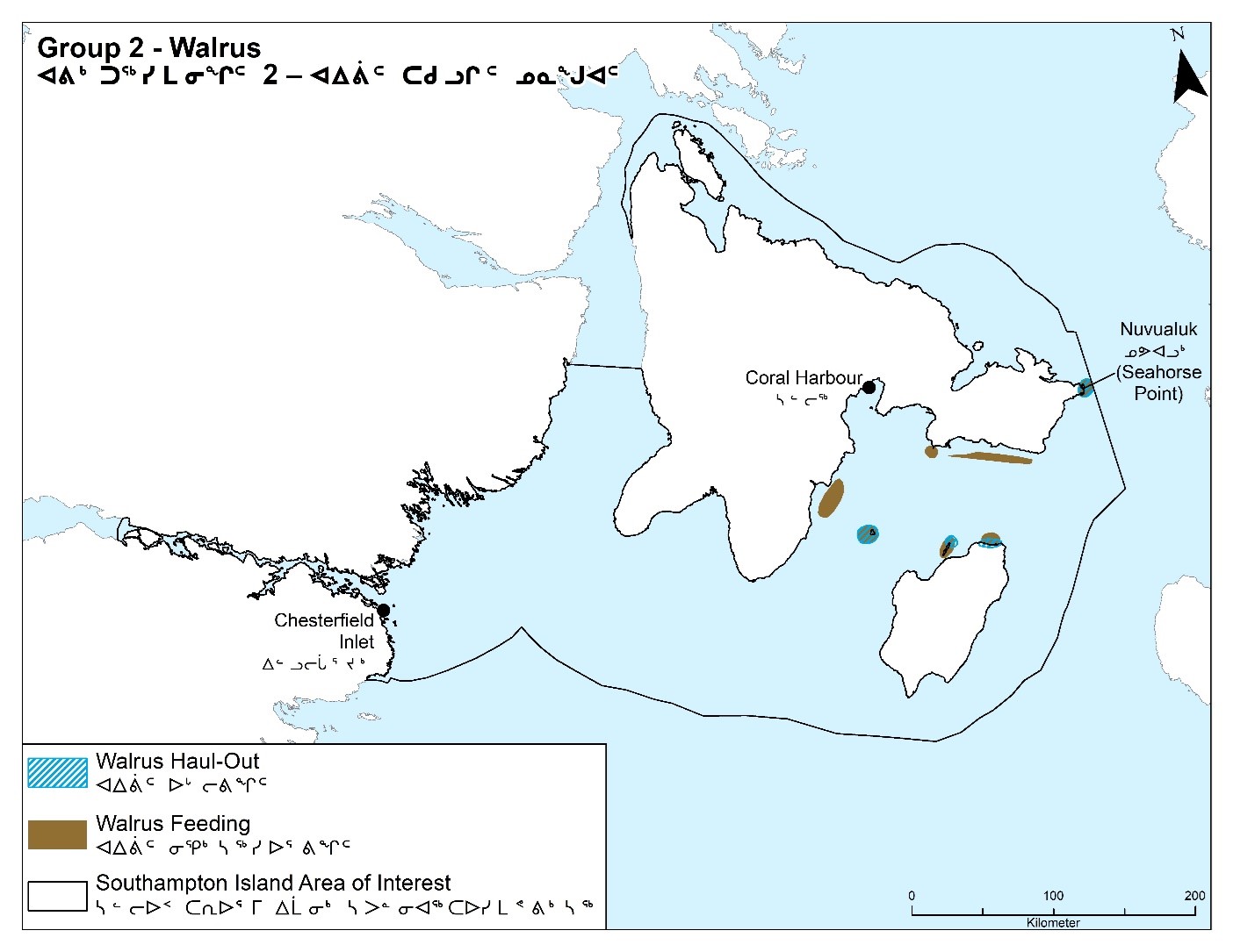
- Group 3: Haul-outs, feeding. Calving on haul-out sites (Figure 2).
Question 3: What activities might be affecting walrus?
Answers
- Group 1:
- Hunters, outfitters, divers, killer whales and polar bears have an impact.
- Submarines have been sighted around CH and CI.
- Group 2: Noise pollution and ice breakup by ships are driving away animals.
- Group 3:
- The routes that vessels, mining supply ships use. Noise pollution causing disturbance and displacement.
- Traffic volume is higher in the last 5 years, since the mine opened.
Question 4: What is it about these activities that may cause an impact?
Answers
- Group 1: Sound of the ships passing through and going too close to SI and Coats Island, and to the little island between them, is affecting the animals.
- Group 2: Noise pollution and ice breakup by ships are driving away animals.
- Group 3: Routes and noise of vessels causing displacement of haul-out sites.
Question 5: Are there other areas within the AOI that are especially important for walrus?
Answers
- Group 1:
- CI hunters also hunt near CI or around Naujaat area.
- There are also walrus up towards Naujaat in the areas called Aqiarurnaq and Qikiqtaaluk (White Island) and in the areas between CH and CI and along CH coast.
- Group 2:
- Areas near Walrus and Coats islands, and north of White Island are being affected.
- Group 3:
- Feeding areas near Depot Island and south of Marble Island.
- Smaller haul-out sites closer to Wager Bay.
Question 6: When are walrus most vulnerable?
Answers
- Group 1: Sometimes hunters and polar bears cause vulnerability when they accidentally miss trying to kill the walrus. When they have injured it but not killed the walrus.
- Group 2: During summer season when ships and vessels are operating.
- Group 3: June-October, during highest activity in the area.
Question 7: What do you think is most important to know about walrus?
Answers
- Group 1:
- Always remember walrus are very dangerous when they are disturbed too much. They can easily break through a boat.
- Some walrus carry a disease called trichinosis. “We need a lab for testing walrus meat before it is eaten either in Kivalliq Region or Nunavut”.
- Group 2:
- Haul-outs (Figure 3).
- Feeding (Figure 3) and birthing grounds are very sensitive to noise pollution.
- Never to leave excess meat when hunted and keep area clean (hunter’s job).
- Testing of trichinosis is needed.
- Group 3:
- Health of walrus, quality of food, and the toxins that might be in a walrus.
Long description :
| Legend ID | Species / features | Accompanying information |
|---|---|---|
Walrus migration (1) |
Walrus |
Movement in fall (southeast) and spring (northeast) |
Walrus migration (2) |
Walrus |
Cape Dorset in winter |
Walrus migration (3) |
Walrus |
Movement decreasing during ice breakup |
Walrus calving (1) |
Walrus |
Calving, mostly empty |
Walrus calving (2) |
Walrus |
Calving on Walrus Island (5,000 to 10,000) |
Walrus wintering |
Walrus |
Small island, walrus here midwinter |
Walrus haul-out |
Walrus |
Haul-out |
Walrus feeding (1) |
Walrus |
Spring/summer reef feeding areas (moves with current) |
Walrus feeding (2) |
Walrus |
Feeding at Depot Island |
Walrus feeding (3) |
Walrus |
Feeding all year, increasing in summer (scallops, oysters, mussels, seals, ringed seals, etc.) |
Walrus |
Walrus |
Changes in past 20 years |
Long description :
| Legend ID | Species / features | Accompanying information |
|---|---|---|
Walrus haul-out |
Walrus |
Haul-out |
Walrus feeding |
Walrus |
Feeding |
Arctic char along the coastline in and around the community of Chesterfield Inlet
Question 1: When do Arctic char use the coastline in and around the community of Chesterfield Inlet?
Answers
- Group 1: They go downriver in the spring. In the summer they are in the ocean. They climb in early fall to fall
- Group 2: They start going down the river at the end of June to the ocean and feed.
- Group 3: June and July.
Question 2: How do Arctic char use the area?
Answers
- Group 1:
- Feeding in CI area and do not get as big as other Arctic char in other communities, like Naujaat.
- Group 2:
- Feeding in the ocean.
- Climb the river and lake. They have a rotating cycle:
- In some years some of the fish migrate to the ocean while others stay in the lake.
- In other years the fish that travelled to the ocean will stay and the fish that stayed will migrate to the ocean.
- No major illnesses observed.
- Group 3:
- Feeding, fishing and spawning areas identified (Figure 4).
Question 3: What activities might be affecting Arctic char?
Answers
- Group 1:
- Shipping.
- Vessels traveling up the channel (CI).
- Arctic char can hear gunshots.
- Invasive species – Salmon caught in CH.
- Group 2:
- Noise pollution.
- Accidental gas spills, driving fish away.
- Group 3:
- Climate change.
- Pollution from the powerplant.
- Noise and vibration coming from ships and also activities on land.
Question 4: What is it about these activities that may cause an impact?
Answers
- Group 1:
- People netting fish during low tide are not successful at Apurnaaqtut.
- Too much vessel traffic: all summer, all day, all night, they may be impacting fish.
- Group 2:
- The only concern is the natural cycle of the weather. (This breakout group wasn’t as concerned about Arctic char).
- “Some fish would end up stuck because of the river icing over. Hunters would have no choice but to catch the fish that get stuck in the river that iced over. It is no wonder, as they would just waste away in the river if they weren’t caught”.
- Group 3:
- Impacts on migration, which seems more erratic.
- Migration also depends on food.
- It is not known where Arctic char are moving.
Question 5: Are there other areas within the AOI that are especially important for Arctic char?
Answers
- Group 1:
- There are 2 different types of Arctic char in CI area:
- white fish
- red meat (in deeper area, best to eat).
- Group 2:
- Popular fishing place near CH, it becomes a concern when the depth of the river is shallow from lack of rain, the flow of the river is not sufficient.
- Group 3:
- Marked migration areas and added a couple of other areas (Figure 4).
- In the late 1980s and early 1990s, Uvajuq, Akuq, Qimatujuarvik, Qasigiarsiurvik and Sungaarnarsivik rivers were all bringing in 25,000 pounds of Arctic char, but not anymore.
Question 6: When are Arctic char most vulnerable?
Answers
- Group 1: When there is shipping going up and down.
- Group 2: When the fish are going up the river, when it’s dry and the water becomes low.
- Group 3: When they are going downstream, out into deeper water.
Question 7: What do you think is most important to know about Arctic char?
Answers
- Group 1:
- Fish are very good. They are the best to eat!
- Monitoring only the 4 areas by DFO.
- They do not monitor this area.
- There are many rivers over there.
- They are not known by DFO because they haven’t counted them yet.
- The only quota known of in the CI area is by Ferguson.Footnote 1
- Group 2:
- Fish are delicious.
- Fish go upstream in any river. They do not just climb a particular river.
- Group 3:
- No stock assessment for Arctic char around SI. Do not really know biomass or how many Arctic char there are. Probably more vulnerable than walrus. There are unknowns and we need to more about Arctic char.
- CI has not hit the quota since shipping increased (used to get 20,000 pounds in 1 month in Fish Bay, only got 2000 pounds in summer 2019). The biggest disturbance was a fuel tanker that came down in 2019, right in front of CI, and the fuel line went into our bay.
- We need to seriously review the routes for shipping and when the traffic can occur.
- The opportunities will only keep increasing. If we just allow it, we will create starvation. We have to be careful with what we allow. There are species that must feed. Sculpin may be the only species that feed.
- The fish are most sensitive. Their habitat is most sensitive to our impacts. They can give up. We have to be sensitive to the animals around us.
- All lake fish go downstream. They will go when it is their time. Not all fish will remain lake fish. They all have the ability to go downstream. Thankful for delicious fish.
- Someone caught a trout in the sea before.
- In one study on Arctic char:
- Oldest fish was 34 years old and youngest was 2 years old; they live quite a while.
- Average weight was 32 lbs, 8-9 lbs for younger fish.
- Some fish have plastics in stomach.
- Migrations depend on food.
- Need better understanding of the seasonal migration, more in-depth scientific studies: “The rest we know about; fish we don’t know about.”
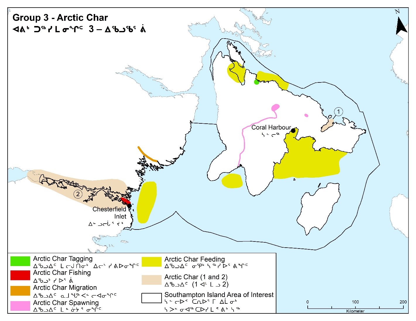
Long description :
| Legend ID | Species / features | Accompanying information |
|---|---|---|
Arctic char tagging |
Arctic Char |
Fish tagging |
Arctic char fishing |
Arctic Char |
Fishing |
Arctic char migration |
Arctic Char |
80 miles |
Arctic char spawning |
Arctic Char |
Spawning grounds |
Arctic char feeding |
Arctic Char |
Feeding grounds |
Arctic char (1) |
Arctic Char |
Important |
Arctic char (2) |
Arctic Char |
Use |
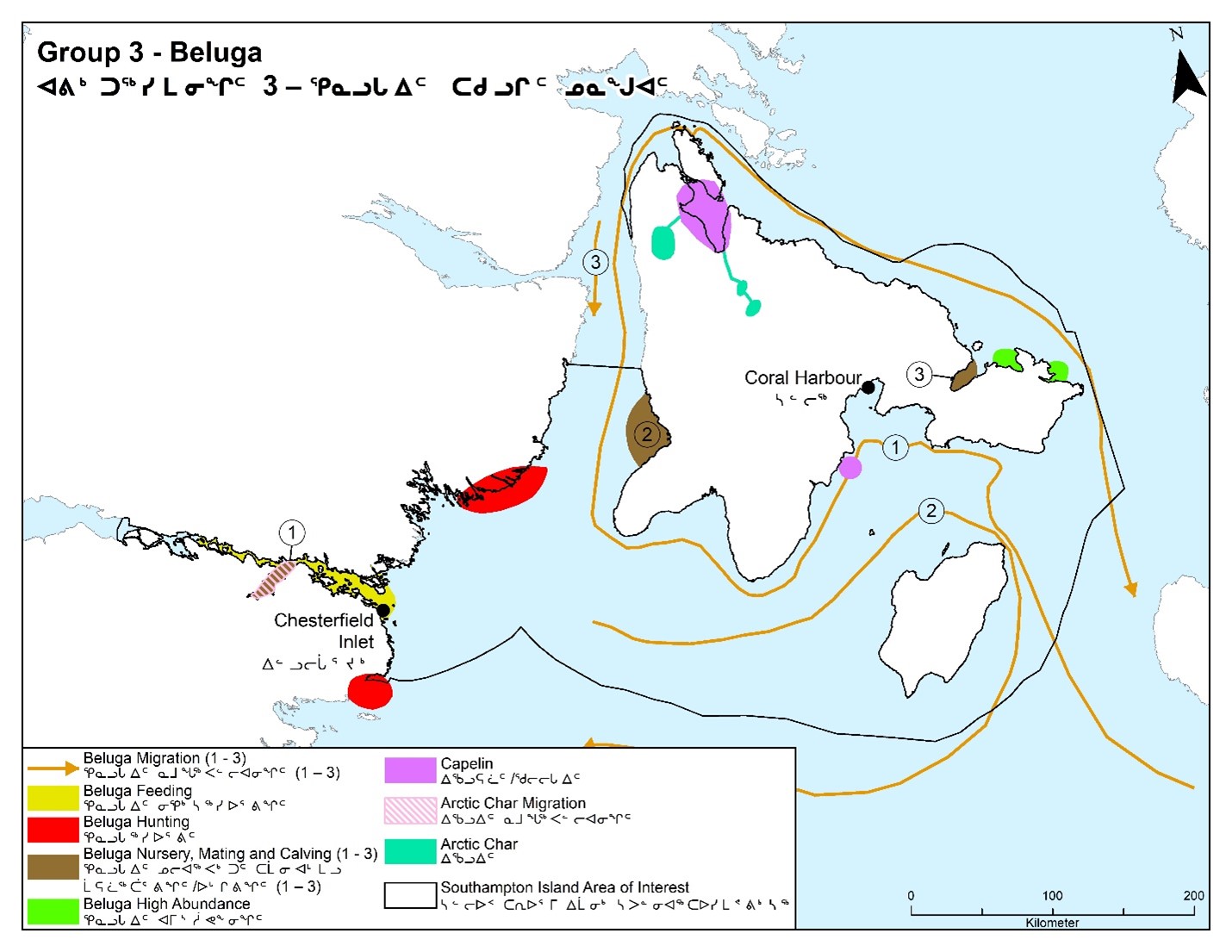
Belugas within the AOI
Question 1: When do belugas use the AOI?
Answers
- Group 1:
- April to November.
- Sometimes they come from up there in Naujaat instead.
- Group 2:
- Start arriving around April, in early spring, start seeing them in Kuuraaluk and Nuvualuk (Figure 5). On the east coast of SI, it is open water throughout the year, the current is always moving along the edge. It is impossible for Inuit to go along the east coast because of the mountain, can’t take an All-Terrain Vehicle (ATV). In the summer, right up to August, belugas are all along the coast.
- Throughout the winter in migration, they go in between CD (Cape Dorset) and CH; this part between CD and CH does not ice over, it remains unfrozen, so the whales stay around here.
- Group 3: (See Figure 6)
- CI start hearing them in May.
- CH at floe edge April/May. Waiting in leads and ice-free areas.
- When the ice starts moving, we catch them, end of May and for the whole summer.
- Try not to get them when skin is yellowish, skin has to be nice and white.
Question 2: How do belugas use the area?
Answers
- Group 1:
- There used to be calving grounds near CI and birthing at Nuvualuk (Seashorse Point)
- Group 2:
- Feeding and calving ground. In winter where the currents flow between CD and CH. North side of Coats Island.
- Group 3: Mostly feeding, migrating through area (Figure 6). 2 groups of belugus.
- Eastern Hudson Bay population comes from Baffin Bay wintering area, these are 20-30% bigger ad healthier than Western Hudson Bay belugs (marking on map) go along this coast from Seahorse Point, all around. Some go through here. Some migrate back down through here.
- Routes marked on map (Figure 6).
- Western Hudson Bay population migrates through Churchill, all the way to CH area. After feeding they migrate back down. Western Hudson Bay belugas just loop around and go down to Churchill area and James Bay and back to St. Lawrence River.
- Main river for Arctic char. There is a big lake called Cleveland Lake. Capelin are here too. There are 2 lakes almost connected that are used by the Arctic char. Tasiuralik Lake is identified. It is main feeding area for whales and seals that feed on capelin.
- Calving areas are in shallow sandy areas. In and around East Bay is known calving and molting area.
- Beluga feeding on squid, cod, capelin. Shift in diet from arctic cod to capelin. Capelin are eaten by whales, seals and bearded seals.
- In CI area, when the ice starts breaking in the spring, belugas go south.
- In the mid summer/fall, they go north, they migrate the other way.
- They have thick skin when they are migrating.
- After their migration is done, down in the Churchill area, they molt in the shallows of Churchill River.
Question 3: What activities might be affecting belugas?
Answers
- Group 1:
- Shipping companies are distracting the belugas causing a decline in belugas.
- Also, along the CH coast there are fish researchers disturbing the beluga.
- More outboard motors, louder.
- Entrapments.
- Group 2:
- Ships, killer whales, research activity, boats, hunters, but belugas always come around no matter what.
- Group 3:
- Ships, noise pollution, research activity (instruments deployed in the water that make noise).
- Movement of the whales is affected by vessels, so many vessels working around that area. Once the vessels leave, we start seeing more belugas close by, but they are not as many as they used to be.
- Killer whales.
Question 4: What is it about these activities that may cause an impact
Answers
- Group 1:
- Back then they used to just follow slowly, that used to work better. Now, they are going fast and trying to get as many as possible.
- They should be treated similar to caribou in terms of way of harvesting.
- Same as caribou: need to let the first group of beluga pass through and can go and start hunting the second round of beluga.
- Fewer beluga in the region.
- Group 2:
- Causing groups of whales to separate; whales are more scattered. Used to be 70 to 80 belugas in a group, now we see groups of 7 or 8.
- Killer whales, boats (all sizes). Research activity, boats and hunters.
- Sea ice formation can cause a natural disaster. Ships traversing the area.
- High-tech gadgets on vessels (e.g., depth sounders); submarines: when one of the monitors from Nunavut Tunngavik Incorporated’s Inuit Marine Monitoring Program was heading back from Coats Island, saw the periscope of a submarine.
- Group 3:
- Research vessels causing displacement.
- Whales going closer to shore, to avoid them.
- Any animal group that stays together, does not make a decision as a group. There is always a leader that makes it go their way.
- Western Hudson Bay whales overwinter in Hudson Strait and down to St. Lawrence Estuary area. They are thinner.
- The Eastern Hudson Bay pod goes up to the Baffin Bay area and inters there, just like narwhals. Healthier than the Western Hudson Bay group.
- Migration in spring is south, in fall they migrate north. Whales have thick skin before molt.
- Affects feeding and foraging in deep waters.
- Fewer whales outside CH.
- Belugas diet is similar to walrus.
Question 5: When are belugas most vulnerable?
Answers
- Group 1:
- When the belugas are wounded and not killed.
- Raising calves, and when there is too much ice.
- Early freeze up and climate change.
- Group 2:
- Sea ice formation can cause natural disaster when they are trapped in forming sea ice.
- Shipping season.
- Where they are migrating.
- Group 3:
- June to October, in shipping corridors.
- The bigger the pod, the healthier the whales. Smaller groups are hungrier, less healthy.The ones from Baffin Bay tend to go more on the side, there are some migrating all the way around the coast (Figure 6). There used to be some in Qinngua, but no more; belugas stopped migrating in that spot. Nursery identified (Figure 6). As soon as the ice is gone, they go in there and stay there all summer.
- Beluga general, around White Island.
- The shallows are 4 miles down. Molting out here in the shallows. There’s migration route too.
- The main current in Roes Welcome Sound is always in one direction (south).
- Claire shared that capelin spawn on beaches. That would bring the belugas in.
- Belugas are shifting their diet to capelin because there is less arctic cod. In Cumberland Sound, belugas feed mostly on capelin now and less on arctic cod. Same thing is happening with Eastern Beaufort Sea beluga population.
- Hunting area (Figure 6). This area here is within reason. To go beyond that you have to spend a little more to get where you want to go. But to hunt on your own, this is within reason.
- CH hunters travel all the way out to get to summer whales. All the way up the Chesterfield Inlet to Baker Lake (BL) for landing the whales.
- 3 areas confirmed as abundant in beluga and for molting, birthing and nursing.
Question 6: What do you think is most important to know about belugas?
Answers
- Group 1:
- Beluga are most delicious in spring and all year.
- Group 2:
- IQ from elders is that the first group of beluga migrating through had to be left alone, so next group will follow through.
- How to harvest the meat, it can be dried and used, and the muscle used for for sinew.
- Sea ice formation can cause natural disaster, traps them in forming sea ice.
- Narwhal come a little later, behind the belugas. Narwhals and bowhead whales come in April.
- Sometimes people harvest from the floe edge.
- To find out more about where they are migrating and more about their health.
- Group 3:
- Research activities are happening: DFO, universities, research vessels out there.
- Community needs to be informed.
- Still using 100 year old maps, need updated bottom mapping.
- It would be nice to get bathymetric maps updated and be safer. Want more research on bottom mapping.

Long description :
| Legend ID | Species / feature | Accompanying information |
|---|---|---|
Beluga calving grounds |
Beluga |
Calving grounds |
Beluga migration (1) |
Beluga |
On the east coast of SI (Southampton Island), it is open water throughout the year, the current is always moving along the edge. |
Beluga migration (2-5) |
Beluga |
Migration |
Beluga summering |
Beluga |
In the summer they are all along the coast. |
Chesterfield Inlet and Coral Harbour Follow-up Broader Community Validation
There are many finger inlets north of Daly Bay, and in the summer beluga swim into them, though people are not sure from where. These beluga are bigger and longer than the beluga from Churchill.
Chesterfield Inlet and Coral Harbour Follow-up Broader Community Validation
With respect to what was shared by Group 3 in response to how belugas use the area, although these 2 groups were identified as Eastern Hudson Bay and Western Hudson Bay populations at the workshop, it is uncertain whether this should be taken as corresponding to those populations as identified by the scientific community. Alternatively, based on a subsequent conversation, it could be that the 2 groups are a stock summering around Churchill, and a stock summering farther north (e.g., north of Daly Bay) consisting of the bigger belugas. Further in depth dialogue would be needed to verify knowledge pertaining to the 2 groups of belugas.
Long description :
| Legend ID | Species / feature | Accompanying information |
|---|---|---|
Beluga migration (1) |
Beluga |
Baffin Bay whale migration |
Beluga migration (2) |
Beluga |
Western Hudson Bay whale migration |
Beluga migration (3) |
Beluga |
Migration |
Beluga feeding |
Beluga |
Feeding |
Beluga hunting |
Beluga |
Hunting |
Beluga nursery, mating and calving (1) |
Beluga |
Nursery. Five rivers sea run char |
Beluga nursery, mating and calving (2) |
Beluga |
Shallows. Beluga mating and calving? |
Beluga nursery, mating and calving (3) |
Beluga |
Mating and nursery |
Beluga high abundance |
Beluga |
High abundance |
Capelin |
Capelin |
Capelin |
Arctic char migration |
Arctic Char |
Nursery. Five rivers sea rund char |
Arctic char |
Arctic Char |
Arctic char |
Seals (Harp, Harbour, Ringed and Bearded) within the AOI
Question 1: When do seals use the AOI?
Answers
- Group 1:
- Seals are around all year.
- Group 2:
- The whole year round. Seals are mostly alike, except for harbour seals which go up the river following the fish.
- Group 3:
- All year (Figure 7).
- CI: Bearded seals abundant in October.
- CH: Bearded seal end of Jan-Feb/March.
- Fewer seals compared to 10 years ago.
- Hunting on the ice Nov-May (also all year).
- Too dangerous to hunt from CI because of currents.
- So not as concerned about noise pollution with seals.
Question 2: How do seals use the area?
Answers
- Group 1:
- Food, eating, calving, and resting.
- Group 2:
- The whole Arctic Ocean.
- Group 3:
- Feeding, pupping (close to CH for ringed seals; Figure 7), mating, not sure of migration routes but likely food throughout season.
- Seem to emerge more when ships are gone.
- There are some seals that will winter on lakes shown in map (harbour seal; Figure 7).
- Shipping season, noise, killer whales, cruise ships.
Question 3: What activities might be affecting seals?
Answers
- Group 1:
- Ships are the main reason seals are decreasing.
- Polar bears and other main predators like fox, wolf are affecting the seal populations. They feed on the pups when they are born.
- Polar bear quota system is a factor.
- Group 2:
- Icebreakers (especially harp seals), and predators (Inuit, polar bears) hunting them.
- Bearded and ringed reals hang around; harp seals go south.
- Group 3:
- Shipping season, noise, killer whales, cruise ships.
Question 4: What is it about these activities that may cause an impact?
Answers
- Group 1: There are more polar bears feeding on seals.
- Group 2: Too many polar bears catching the seals.
- Group 3: Less impact on seals than whales, as seals are not as easily disturbed. Impact on feeding most important.
Question 5: When are seals most vulnerable?
Answers
- Group 1: March for seal pups.
- Group 2: When the ice-breaker ships are going through the ice.
- Group 3: When they’re pupping. Changes to their food (fish) will have an impact on seals. There are 5 rivers identified that have seals, including Qamaniq.
Question 6: What do you think is most important to know about seals?
Answers
- Group 1:
- Need a study of denning mortality rates. Seals are more vulnerable now. Need more studies on wolverine and land predators, and seal pupping dens.
- Group 2:
- Population size and trend (decreasing or increasing).
- Can make clothing out of seals.
- Source of food.
- Group 3:
- Seals are most important because Inuit use them for clothing, it is the food they eat, and they don’t want to lose seals.
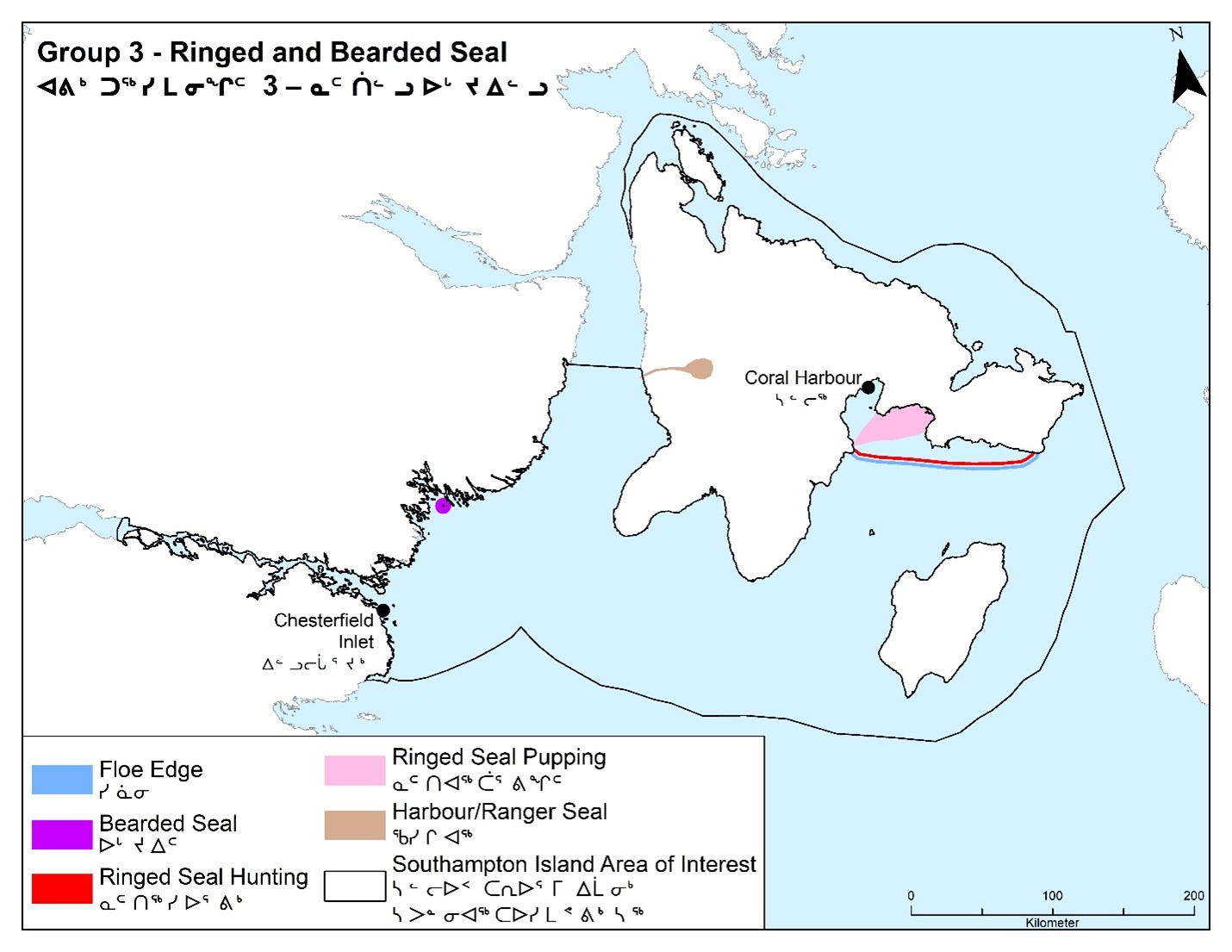
Long description :
| Legend ID | Species / feature | Accompanying information |
|---|---|---|
Floe edge |
Floe Edge |
Hunting on floe edge |
Bearded seal |
Barded Seal |
Inside of walrus area |
Ringed seal hunting |
Ringed Seal |
Hunting on floe edge |
Ringed seal pupping |
Ringed Seal |
Pupping |
Ringed seal |
Ringed Seal |
Ringed seal |
Chesterfield Inlet and Coral Harbour Follow-up Broader Community Validation
There used to be a lot of seals between Barber Bay and Daly Bay, not as many are seen there anymore. There are many finger inlets north of Daly Bay.
Seabirds around Coats Island
Question 1: When do seabirds use the area around Coats Island?
Answers
- Group 1:
- When are akpait there. Spring to fall season.
- Group 2:
- Early spring.
- CH people don’t go to Coates Island often, and when they do, they only go for a brief period. So, they have awareness but not a lot of knowledge in this area. There is a lot of open water and water movement between CH and Coats Island, have to be careful traveling. CH people go to Coats Island in late July and August to catch caribou.
- “It’s better to ask the researchers that have been working on Coats Island for 20 years about the seabirds”.
- Around CH, we do not see many shorebirds anymore, sigjariarjuit, siggulii, qulli−qulli, etc.
- Question about whether pitsiulaat (black guillemots) are over populated. They seem to remain all winter. They seem to be the ptarmigan of the sea. East Bay area in Inuktitut is called QilaliarvikFootnote 2: “close to heaven”.
- Group 3:
- Ealier than snow geese (late spring to mid-May).
- Stay the whole summer into October.
Question 2: How do seabirds use the area?
Answers
- Group 1:
- Feeding, nesting, breeding and migration.
- Group 2:
- On northeast side, there are cliffs, a “wall of birds” (murres). That is why it is called Akpatuurjuag.
- Group 3:
- Murres – nesting sites, feeding (krill, small oyesters, fishes) (Figure 8)
- Migration area for snow geese and Canada goose, swans, cranes.
Question 3: What activities might be affecting seabirds?
Answers
- Group 1: Polar bears, researchers, seagulls, foxes, animals that eat akpat. Shipping companies are affecting the food and so is plastic waste. Avaian chlarea mitirnut.
- Group 2: Overabundance of geese.
- Group 3: Climate change. Overharvesting eggs. Predation on eggs by people, polar bears and foxes. Pollution.
Question 4: What is it about these activities that mau cause an impact?
Answers
- Group 1: We didn’t really discuss it.
- Group 2: No answer.
- Group 3: Invasie species, such as bald eagle, coming north because of climate change or other reasons. Earlier nesting impact feeding.
Question 5: Are there other areas within the AOI that are especially important for seabirds?
Answers
- Group 1: Tuktutuuq. Ikkattuaq (Harry Gibbons) Migratory Bird Sanctuary.
- Group 2: We need to ask researchers about this as they are more knowelgeable.
- Group 3: No answer.
Question 6: When are seabirds most vulnerable?
Answers
- Group 1: When they have laid eggs and when they hatch into chicks.
- Group 2: When they lay eggs and have chicks.
- Group 3: Unsure when.
Question 7: What do you think is more important to know about seabirds?
Answers
- Group 1:
- Arctic terns and black guillemots are vanishing.
- Monitoring of our everyday sustenance, what we rely on, on a daily basis, like fish, sculpin, mussles would be easily affected if there was a spill.
- The ocean has to be kept clean. There are a lot of plastics in the ocean now.
- “Our food, for us, the elders, we have been eating our food for all our lives, since so long ago. But here is what happens now. The white man’s laws, by boards, national boards are reporting that animals are disappearing. This is frustrating. Especially for me, as an elder. So frustrating”.
- Group 2:
- We need more research about this area and species, including: sigjariarjuit, siggulii, qulli−qulli, etc. We don’t see them as much anymore.Red knots, red phalarope (bird with long beak).
- Group 3:
- Nesting sites most important place for protection. Some eider ducks leave and some stay (4 types of eider ducks).
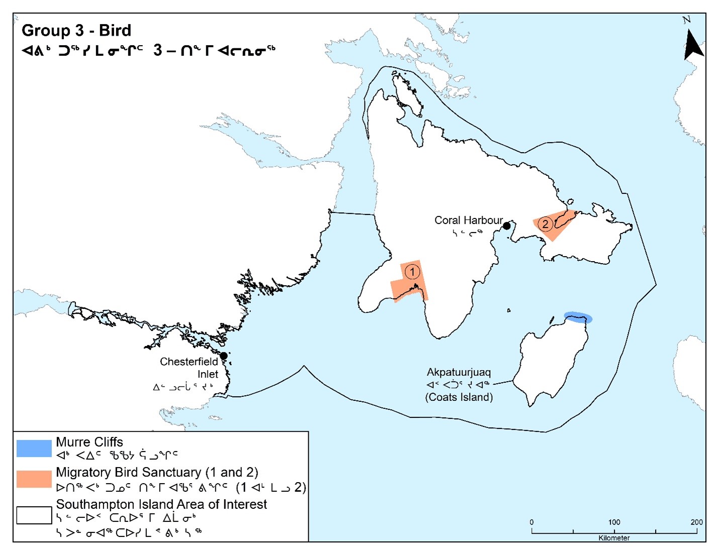
Long description :
| Legend ID | Species / feature | Accompanying information |
|---|---|---|
Murre cliffs |
Murre |
On northeast side at Coats Island, there are cliffs, a “wall of birds” (murres). That is why it is called Akpatuurjuaq. |
Migratory bird sanctuary (1) |
Bird |
Ikkattuaq (Harry Gibbons) Migratory Bird Sanctuary |
Migratory bird sanctuary (2) |
Bird |
Qaqsauqtuuq (East Bay) Migratory Bird Sanctuary |
Habitat and specific areas
The following habitat and specific areas were inquired about as part of the questionnaire:
- kelp
- Duke of York Bay and White Island
- the coastline in and around the Chesterfield Inlet
- the East Bay extending into Foxe Channel
- the Roes Welcome Sound
- the area between Southampton and Coats islands
- other areas which are especially important
Below are the responses by each group for each question.
Kelp
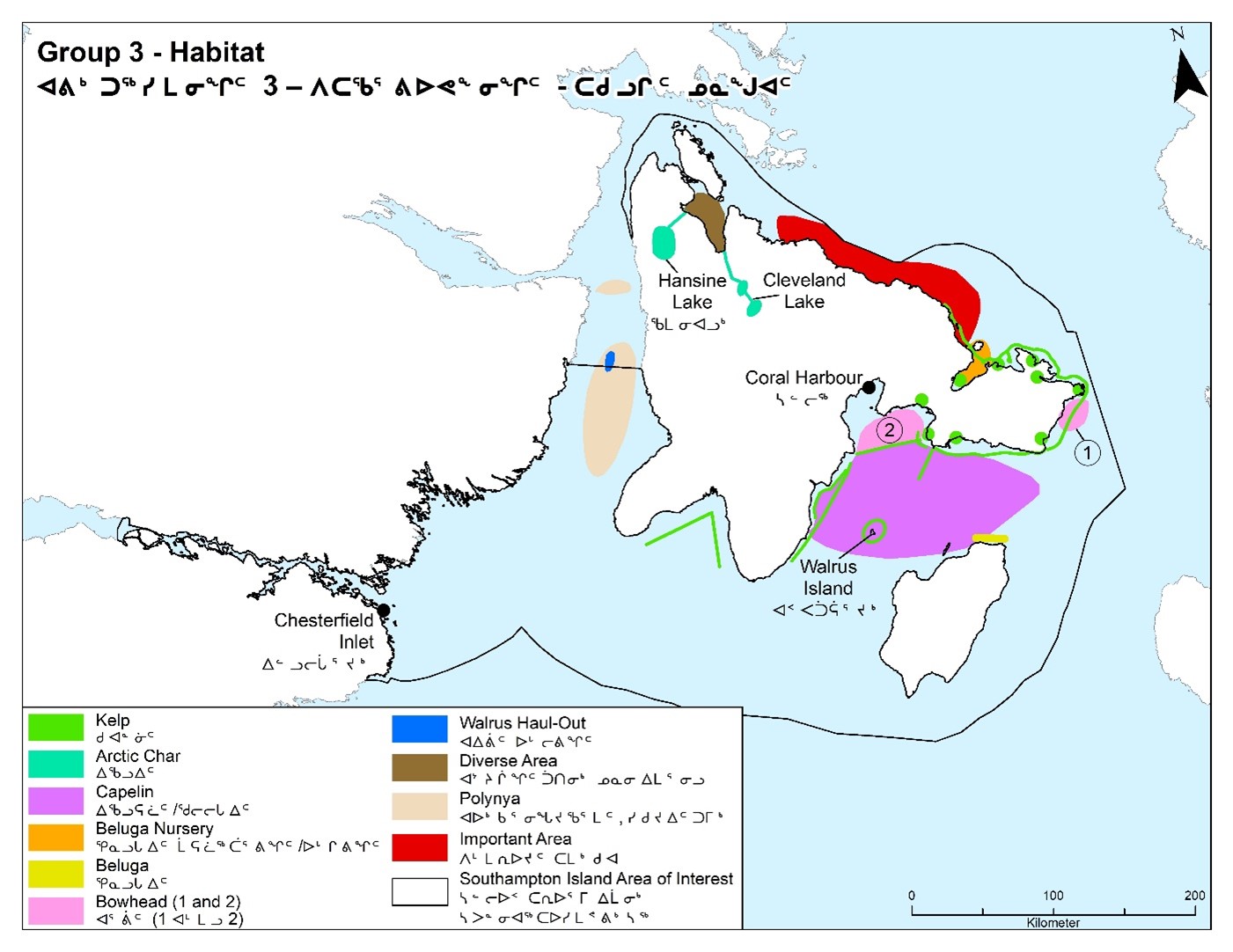
Kelp beds can be important areas of productivity. We know there are kelp beds in the nearshore coastal environment around Southampton Island.
Question 1: Where are the kelp beds within the AOI?
Answers
- Group 1:
- Near CI, all the way up to BL, also north up the coast towards Naujaat and south towards RI (Figure 9)
- Group 2:
- Number 1 to 7 on map (Figure 10)
- Group 3:
- Marked on map (Figure 11):
- Walrus Island, just below tide line.
- Kelp don’t like sandy bottom; they like rocky bottom. There are many different kinds of kelp. Sunlight penetrates to 30 feet.
Question 2: Do you see any special activity in terms of the types of animals (fish, invertebrates, birds, seals, etc.) related to these kelp or areas of aquatic vegetation?
Answers
- Group 1:
- A lot kelp is seen by CH people when they are seal hunting (Figure 9).
- Group 2:
- Seals lie (rest) on kelp only when kelp are loosely floating on the surface.
- Kelp are also a good source of vegetation for Inuit, polar bears and caribou. Not sure whether birds eat kelp.
- Group 3:
- Species around kelp:
- Small fish, little rock cods, and crabs, seals, especially in front of CH

Long description :
| Legend ID | Species / feature | Accompanying information |
|---|---|---|
Beluga migration (1) |
Beluga |
Beluga’s main route. Belugas start to come up north during fall season and start heading back in August/September for migration |
Beluga migration (2) |
Beluga |
Larger belugas |
Beluga migration and high abundance |
Beluga |
A lot of whales in the area. Beluga and bowhead route (August to September and Spring/Summer April to July). No change of sea mammals. |
Bowhead migration and high abundance |
Bowhead |
A lot of whales in the area. Beluga and bowhead route (August to September and Spring/Summer April to July). No change of sea mammals. |
Clam |
Clam |
Clam |
Kelp |
Kelp |
Kelp beds salt-water) |
Walrus high abundance |
Walrus |
Lots of walrus |
Walrus hunting and feeding |
Walrus |
Hunting and feeding. This is important for walrus (Walrus Island) |
Walrus |
Walrus |
Walrus |
Seal hunting |
Seal |
Seals are different taste because of sea water |
Caribou |
Caribou |
The whole island (Coats Island) has caribou. This is important for caribou. |
Bird sanctuary |
Bird |
Ikkattuaq (Harry Gibbons) Migratory Bird Sanctuary |
Bird |
Bird |
Sea mammals and birds all year round. |
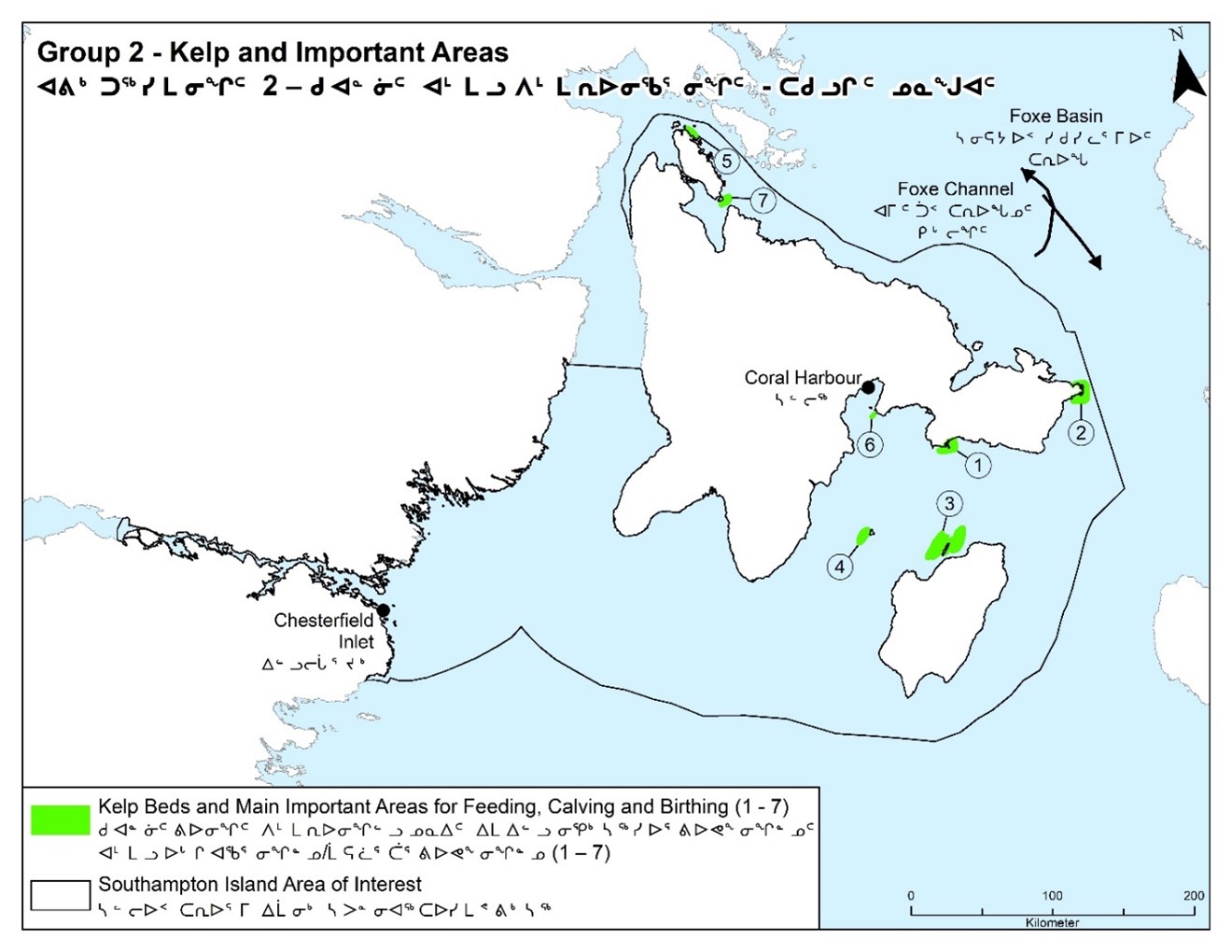
Long description :
| Legend ID | Species / feature | Accompanying information |
|---|---|---|
Kelp (1 – 7) |
Kelp |
Kelp beds and main important areas for feeding, calving and birthing (areas 1 to 7) |
Why is the Duke of York Bay and White Island on the north side of Southampton Island important?
Question 1: What do you find in this area?
Answers
- Group 1:
- Seals, caribou, bearded seal, walrus, beluga, bowheaded, narwals, polar bears, wolves, krill, capelin, maybe crabs.
- Group 2:
- It is rich in wildlife – and different kinds. Like a zoo.
- “The heart of the animals”. Polar bear, caribou, rabbit, fish, beluga, seals, narwal, akpat, killer whale, bowhead.
- Group 3:
- Diverse area Figure 11.
- The whole bay is full of Arctic char. Seals, walrus, beluga, narwhal, killer whales, and bowhead use this area.
Question 2: When do species use the area?
Answers
- Group 1:
- All winter.
- Group 2:
- Between April to December.
- Group 3:
- Marine mammals use area from June to August.
- Seal holes in April.
- Some areas from Seahorse Point to Duke of York Bay, wgere tgere was depth sound test to look for shrimp 10 years ago.
Question 3: How to species use the area?
Answers
- Group 1: Calving area and a feeding ground, hunting.
- Group 2: Feeding and hunting (surviving), calving, birthing. Good current for the animals. (Kakiliniq) It is rich in food. It can get covered in seaweed.
- Group 3: It is a feeding ground for all marine mammals. Polar bears use White Island from the east side of SI, and from Seahorse Point to White Island.
Question 4: Are there areas more important than the others?
Answers
- Group 1:
- No.
- Group 2:
- Main area for belugas: calving, birthing and feeding.
- The whole surrounding area is all important. It is the most important area because of the variety of wildlife.
- Group 3:
- It can get quite deep, 500 to 600 feet, but it could get to 1000 to 1500 feet.
- There are some areas where depth sound tests to look for shrimp were carried out 10 years ago (around East Bay, along east coasts of Coats Island and Seahorse Point).
Long description :
| Legend ID | Species / feature | Accompanying information |
|---|---|---|
Kelp |
Kelp |
Kelp |
Arctic char |
Arctic Char |
Hansine lake and Cleveland lake |
Capelin |
Capelin |
Capelin |
Beluga nursery |
Beluga |
Beluga nursery |
Beluga |
Beluga |
beluga |
Bowhead (1) |
Bowhead |
Bowhead |
Bowhead (2) |
Bowhead |
Bowhead at floe edge (July) |
Walrus haul-out |
Walrus |
Walrus Haul-out important area |
Diverse area |
Walrus, Seal, Beluga, Bowhead, Narwhal, Killer Whale, Arctic Char |
Walrus, Seal, Beluga, Bowhead, Narwhal, Killer Whale and Arctic Char |
Polynya |
Polynya |
Open water polynya |
Important area |
Important Area |
All important |
Why is the coastline in and around the community of Chesterfield Inlet important?
Question 1: What do you find in this area?
Answers
- Group 1: Fish, walrus, bearded seal, ringed seal, harbour seal, killer whale, polar bear.
- Group 2: Fish seals, belugas all sea mammals.
- Group 3: Marine mammals. Mussels in low tide,jelly fish that are now different from the ones around CH and Walrus Island, Arctic char, rock cod, claims, sculpins, scallops. Older walrus haul-on sites not there anymore.
Question 2: when do species use the area?
Answers
- Group 1: No answer
- Group 2: Great place for fishing in the summer time.
- Group 3: winter nursery. Mid-winter.
Question 3: How do species use the area?
Answers
- Group 1:
- Calving. Feedin. Hunting.
- Group 2:
- Sea mammals, diet is around the coastline.
- Main area for belugas – calving, birthing and feeding.
- Going downstream, feeding.
- Hunting.
- Commercial fishing somewhere here.
- Group 3:
- Migration routes for geese (rest for Canada geese).
- Get bigger farther north toward Roes Welcome Sound (RWS).
- Nursing area for beluga, near CI.
Question 4: Are there areas more important than the others?
Answers
- Group 1:
- Is affected by a lot of vessels affecting the sea mammals.
- Shallow area and this area is deeper, can go into any cove.
- There was a time when caribou died off because it was so overpopulated at Qikiqtaugaaluk.There are times when caribou get stuck there in early spring, if they do, they’ll remain there all summer.
- The last tuniq, over here, maybe around QilluarjukFootnote 3, over here where it is deep. It was said to say, “you will never see us again”. The tuniq said this will be the last time you see tuniit. The tuniq had been adopted by Inuit. Tuniit and Inuit were telling each other non-truths. So, the arms were grabbed, and they did that. It is said that is what happened. And when it started running, it looked like he had long arms from all the blood going down. Those are the stories my dad used to tell us.
- The last resident that happened to be from CH who saw a tuniq said went to CI. It is said the last one was taken to CI. That is how you have relations from CH.
- Group 2:
- It is important for us because it provides a source of food for us.
- Group: does not know this area.
- May be a big shipping route for BL, as a result there are no more seals, because of the traffic.
- A participant shared that an elder warned the communities based on BL shipping route driving mammals away and that Inuit need to be vocal about these impacts.
- “We need to advocate for our communities”.
- Group 3:
- This is a very high current area and we pointed out some older walrus haul-out sites that are not there anymore.
Why is the East Bay extending into Foxe Channel important?
Question 1: What do you find in this area?
Answers
- Group 1: Walrus, beluga, polar bears, marine birds.
- Group 2: Whales, polar bear, birds.
- Group 3: Beluga, seals, bowhead, variety of foxes, polar bear, shore birds.
Question 2: When do species use the area?
Answers
- Group 1: All year around.
- Group 2: April to May and around November to December.
- Group 3: June to August and Sept. Some polar bears hunt in winter.
Question 3: How do species use the area?
Answers
- Group 1: Calving, feeding, hunting. Trade route between CH and CD (Figure 12)
- Group 2: Calving grounds, birthing, feeding.
- Group 3: Beluga nursery and calving and birthing area.
Question 4: Are there areas more important than the others?
Answers
- Group 1:
- Bird sanctuary (Qaqsauqtuuq (East Bay) Migratory Bird Sanctuary).
- Group 2:
- Calving ground birthing, feeding.
- The main important areas, that offer feeding, calving and birthing, are as listed on the map from 1 to 7 (Figure 10).
- Group 3:
- We talked a little bit about how it was a marshland and how it is getting overgrazed and its mostly soil now, not super marshy.
- Birds are starting to move away from East Bay.
- Caribou have been observed from the shoreline, licking the rocks for salt.
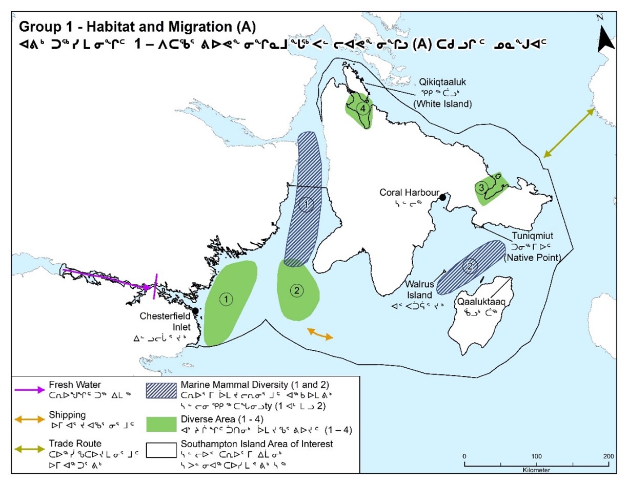
Long description :
| Legend ID | Species / feature | Accompanying information |
|---|---|---|
Fresh water |
Fresh Water |
Fresh water begins here. |
Shipping |
Shipping |
Shipping is a major factor. Sound of ships causing impact. |
Trade route |
Trade |
Trade route between CH (Coral Harbour) and CD (Cape Dorset) |
Marine mammal diversity (1) |
Marine Mammal |
Roes Welcome Sound has a lot of food sources with all kinds of sea mammals. |
Marine mammal diversity (2) |
Marine Mammal |
Sea mammal and birds all year. |
Diverse area (1) |
Walrus, Seal (Ringed Seal, Harbour Seal, Bearded Seal), beluga, Killer Whale, Polar Bear |
Calving, feeding, hunting area. The area would have a lot more animals but due to a lot of ships passing b. Shouth side is more shallow area. No environmental effects. Walrus, seal (ringed seal, harbour seal, barded seal, beluga killer whale and polar bear.) |
Diverse area (2) |
Seal, Beluge, Bowhead, Narwhal |
Calving, feeding, hunting area. All kinds of sea mammals. Seal, beluga, bowead and narwhal. |
Diverse area (3) |
Walrus, Seal, Narwhal, Polar Bear, Bird, Fox |
Calving, feeding, hunting area all year round. Seals of any sort. Bird sanctuary. Walrus, seal, narwhal, polar bear, bird and fox. |
Diverse area (4) |
Walrus, Seal, Beluga, Bowhard, Narwhal, Fish, Poliar Bear, Caribou, Wolf |
Calving, feeding, hunting area. Animals all year round. Duke of York bay has some of the best fish when they go close to the shore. Walrus, seal, beluga, bowhead, narwhal, fish, polar bear, caribou and wolf. |
Why is the Roes Welcome Sound important?
Question 1: What do you kind in this area?
Answers
- Group 1: Walrus, beluga, polar bears, marine birds.
- Group 2: Whales, polar bear, birds. Beluga, seals, bowhead, variety of foxes, polar bear, shore birds.
- Group 3: Belagu, seals, bowhead, variety of foxes, polar bear, shore birds.
Question 2: When do species use the area?
Answers
- Group 1: No answer
- Group 2: All year round.
- Group 3: Some walrus overwinter in this area.
Question 3: How do species use the area?
Answers
- Group 1:
- Calving, feeding and hunting.
- Group 2:
- Calving ground (Figure 5).
- Animals feed there.
- “In the summertime, over here in Uktaaq, there has been so much traffic. It is also shallow. There is a 1 to 2 hour period that you can go through it. Not within the AOI boundary … I don’t know why they left it out. Look how much traffic there is in that route”.
- Group 3:
- There is a very strong current in this area. Migration route. Some walrus overwinter in this area.
Question 4: Are there areas more important than the others?
Answers
- Group 1:
- Between SI and the mainland is used by vessels, and sea mammals in that area are affected.
- Group 2:
- This part has commercial fishing. North tip of SI is the most important because there’s animals and it is used for shipping and it causes disturbance.
- Group 3:
- Whole area is important.
- No areas ore important.
- Research: what vessel found in RWS.
Why is the area between Southampton and Coats Islands important?
Question 1: What do you find in this area?
Answers
- Group 1: Walrus and caribou.
- Group 2: Abundant sea mammals, fish, bowhead, beluga, seals, and walrus are very sensitive mammals.
- Group 3: Core area for walrus and seals. Bowhead, beluga, capelin.
Question 2: When do species use the area?
Answers
- Group 1: No answer
- Group 2: Area is used all year round especially for walrus and seals. Walrus Island is also used by walrus for resting when the ice is gone.
- Group 3: Walrus and seal, all year round. Bowhead in the spring. Beluga migration (spring/fall). Capelin spawning in September.
Question 3: How do specie use the area?
Answers
- Group 1:
- “We talked about a time there was a ship that did not inform wildlife department, the vessel was taking images. We reported them to the wildlife department because we felt it important.
- We want to be able to be welcoming to vessels, but this can only happen if they report to the wildlife department. Someone had been observed that vessels were going in the waters between Akpatuurjuaq (Coats Island) and CH and it was impacting our animals and walrus in the ocean”.
- Inuit travel to Coats Island to hunt caribou, as they are best.
- The land and scenery are very beautiful.
- The community wants to be advised when there is a cruise ship around that area.
- Group 2:
- Feed, breed, rest and raise their young.
- Group 3:
- Beluga migration (spring/fall).
- Capelin spawning in September.
- Capelin prefer to spawn on the shore when it’s colder and move deeper when its warmer. Important feeding area for lots of different mammals.
- Feeding areas.
Are there other areas which are especially important?
Question 1: Are there other areas which are especially important?
Answers
- Group 1:
- Hunters and outfitters also have an impact.
- Submarines have been seen around CH and CI.
- Killer whales have an impact. Polar bears have an impact.
- Too much traffic between CH, CI, and SI and Coats Island and traffic outside of that area also has an impact.
- Group 2:
- North coast of SI called Qikiqtattiaq is most important because the routes used in the area for shipping causes disturbance.
- Walrus Island, Coats Island, Native Bay and Bencas Island areas are most important areas.
- Walrus Island, Seahorse Point (Nuvuani) and Qaaluktaaq (no English name) are used for haul-out.
- Group 3:
- Hunting area. Whole area is important.
Seasons and migrations
The following were inquired about as part of the questionnaire:
Below are the responses by each group for each question.
Migration pathway
The AOI is a migration pathway for beluga, bowhead and narwhal as they move between overwintering and summering areas.
Question 1: What areas are most important to beluga, bowhead and narwhal migration?
Answers
- Group 1: No answer.
- Group 2: East coast to north of the Island is very important because it is used for migrating but disturbance in the area caused by ships.
- Group 3: See Figure 13. Narwhal – mid-April by CI
Question 2: When does Fall migration occur?
Answers
- Group 1:
- August/September
- Group 2:
- Between October and December.
- Most of the belugas prefer shallow areas, migrate going through the shallow area. The very brave ones go into deep areas.
- Group 3:
- Fall migration:
- Bowhead – Sept/Oct
- Beluga – Sept/Oct
- Narwhal – Sept/Oct
Question 3: When do these species start arriving back to the spring?
Answers
- Group 1:
- They seem to return around spring, when it is tuvaaq. They start appearing.
- Group 2:
- April.
- Group 3:
- Calving – mid-summer
- Less use of coastal areas in the fall. More in the deep.
- Spring – feeding. Slower migration than fall. Spring-June sighting April CI.
Question 4: Is the use of these areas the same every year or does it change from year-to-year? Have you observed changes to migration patterns in recent years?
Answers
- Group 1:
- We used to get shipping all kinds from the sealift that carried products for the Nortern and Co-op migration.
- It was very obvious that we immediately got impacted when the mining shipping started.
- When Qamanittuaq opened.
- Group 2:
- Used every year, but belugas are rarely seen going into the habour. The patterns changed for belugas migration.
- Group 3:
- Varies – climate, ice-conditions.
- Too much ice
- Ice all summer, harder to hunt. Floating ice does not melt.
- Foxe Channel – too much ice. Narwhal farther south near CH
- Staying longer – longer open water season
- December (CH)
- Formation later. Marine mammal sightings later
- Killer whales running marine mammals into shallows
- Close to ice-edge or beach.
Question 5: Are there environmental conditions that alter whale migration areas and/or timing (e.g., sea ice extent, increased open water)?
Answers
- Group 1: None.
- Group 2: Unknown. Heard of them being iced over in the north like Igloolik or Pond. Not here though.
- Group 3: Ice-conditions, climate, killer whales, there is less cod.
Question 6: What behaviours are observed during migration (e.g., feeding, calving)?
Answers
- Group 1:
- Feeding, calving.
- Group 2:
- When beluga whales are feeding, they swim in shallow parts and be seen to have motions feeding on one spot and more along the coast. They deliver their young in June.
- Group 3:
- Beluga stay in pods. First group leads.
- East Bay – beluga molting and nursery.
- Duke of York Bay – feeding.
- Beluga feeding on char during migration.
- Halibut and squid on east side of Coats Island.
- When there was a Greenland shark in CH are whales went closer to shore.
- Easier to hunt Western Hudson Bay beluga population.
- Have to go farther to hunt whales means spending more money. The cost of hunting is increasing while demand is growing. This may need financial help if hunting for their families.
- Shipping causes displacement.
- Unpredictable migration.
Question 7: Activities that might affect migration routes (e.g., shipping)?
Answers
- Group 1:
- Shipping a major factor.
- Group 2:
- IQ Knowledge: Inuit and hunters have never been known to disturb whales but as of today more ships are noticed to cause a lot of disturbance.
- Perhaps polar bears.
- Sea ice movement.
- Researcher, sampling, both ways through vessel travel, loud motors, noise pollution.
- Group 3:
- Shipping and vessels.
Question 8: What is it about these activities that may cause an impact?
Answers
- Group 1:
- No answer
- Group 2:
- Mammals sampling can disturb their migration, and ice movement can block their routes.
- Feeding grouds. Increase in polar bears can also disrupt their route.
- Delay in snowfall causes it to have not enough snow on the ground.
- Sea ice breakaway sooner in June. In the past the breakaway would happen in July.
- CH has problem bears mainly around the fall time.
- Group 3:
- No answer

Long description :
| Legend ID | Species / feature | Accompanying information |
|---|---|---|
Narwhal migration |
Narwhal |
Migration during breakup (opposite during freeze-up fall). |
Beluga migration (1) |
Beluga |
Western Group HB (Hudson Bay). |
Beluga migration (2) |
Beluga |
Eastern group BB (Baffin Bay). |
Bowhead migration |
Bowhead |
SH (Southampton Island). |
Whaling camp (1) |
Whale |
Old whaling camp. |
Whaling camp (2 and 3) |
Whale |
Whaling camp. |
Bowhead, narwhal and beluga |
Bowhead, Narwhal and Beluga |
Bowhead, Narwhal and Beluga. |
Beluga |
Beluga |
Beluga. |
Cod |
Cod |
Cod. |
Cod |
Cod |
NFLD (Newfoundland) Cod. |
Other seasonal patterns
Question 1: Are there other seasonal patterns that require consideration?
Answers
- Group 1: “We have always found the seasons wonderful. It is in the fall that the animals, have more abundant meat, both the land animals and the ocean animals have fattened up. In the summer they will be be thinner, but by the fall they have fattened up. Spring is the best time to catch young seals”.
- Group 2: “We seem to be experiencing a delay in snow covering the land (snowfall that remains). The delay changes patterns, for example, delay in polar bear denning. There’s a delay in the ocean icing over, and ice formation is thinner. Sea ice goes away sooner than before; nowadays it goes away mid-June, in the past it used to go away July or August. The Birds arrive sooner too”.
- Group 3:
Priorities and Inuit uses
Question 1: Are there any species that may require special attention?
Answers
- Group 1:
- “All species are important, they need water, they all need a habitat, however, I am frustrated with researchers and their techniques. The technique of collections is causing illnesses because the ocean is very strong. I don’t want our animals to be interfered with like that at all”.
- They say they want them protected and create quotas, including polar bears. They do not know what damage they are causing and yet they are calling themselves experts of animals and creating laws about them, I am frustrated by this.
- The meat that is caught needs to be of concern. Mussles and clams need to be included, as we eat them too.
- Our sea needs to be clean as always. Too much waste in the ocean affects health of animals in the sea and on land.
- Group 2:
- There seems to be a decreased number of shorebirds.
- Group 3:
- Walrus, beluga, Arctic char.
Question 2: Are there specific times of the year when there should be restrictions or prohibitions?
Answers
- Group 1:
- No restrictions for hunters. Too many unemployed. Main source of food. Food in store is expensive,Our ancestors did not prevent any hunting. There were never any prohibitions, not when they allowed us to survive.
- “There are too many regulations right now. That are put on wildlife already, every day”.
- Group 2:
- Restrictions of hunt on polar bears have resulted in increased population of polar bears.
- Fall season, in October, the routes we see on the map for fishing tracks have a lot of effect on the marine mammals.
- CH recommended that the traffic used between Coats Island and SI has had an effect on walrus, future concerns.
- The route needs to be changed for the ships, given that the captain can do whatever they want, since there are no laws.
- For walrus in July, Aug, Sept, because main feeding times; when walrus are hauling out and feeding.
- For beluga when they are molting, and key migration times in spring and fall.
- For Arctic char during spring and end of August.
- Used to clean the fat that was harvested and use it for heating oil.
- Group 3:
- July/Aug/Sept for walrus – main feeding times.
- Key migration times for whales in spring and fall.
- Arctic char in spring when they are coming out of the river, and end of August when they are going upstream.
- There are 2 runs. When they are going upstream, the smaller char come first and the bigger ones come later. It is the recerse when they are coming out of the river.
Question 3: What are the priorities for protection in the AOI?
Answers
- Group 1:
- The Government of Canada has constitution of Canada, Inuit have certain rights.
- All animals that are harvested are priorities. We eat animals that are harvested.
- Group 2:
- Shipping tracks shown as routes used yearly is a major concern for CH because of the traffic which disrupts and disturbs marine mammals.
- To recommend shipping tracks to use the south of Coats Island and stop the routes between Coats Island, Walrus Island and CH. Seahorse Point also included because it is the most important area for breeding, nursing and feeding.
- There was already a recommendation from CH to Nunavut Planning Commission for the Nunavut Land Use Plan, for a 15 km setback from 4 walrus haul-outs plus feeding areas (Figure 3) (was 5 km, now they want it 15 km).
- All the animals that are harvested are priorities because we eat the animals.
- Seahorse Point is most important for breeding, nursing and feeding for all mammals.
- Group 3:
- Walrus haul-outs and feeding sites.
- Beluga whale molting and nursery in 3 areas.
- East Bay calving and molting grounds.
- Economic development (e.g., limestone/gravel on SI).
Current and potential future activities and Inuit uses
Question 1: What activities could be allowed? What activities might have to be restricted?
Answers
- Group 1:
- Allowed: no resitrcitions for animals. Main source of food. Think of younger gnerations. Needed needed for clothing, tents, etc. Used to clean the fat that was harvested. Inuit should never be told not to hunt.
- Sealift: main source of supply. They provide food, bullets, vehicles, ATVs, bullets etc. to our communities.
- Economic development and tourism. Cruiships as long as they are not disturbing mammals.
- Restricted: shipping companies for mining. Greenpeace.
- “It is only a matter of time a road will connect us to Manitoba. There is already a project underway to create a road connecting us to Manitoba. We will start getting hydro power, this is already underway, it is flat lands, so they should just use the roads for mining too it would be better this way. The only thing is the communities of CH and Naujaat cannot be connected by roads because of the mountains over here. Maybe if there was a bridge”.
- Group 2:
- Community resupply are acceptable except the other ships going between the islands.
- Shouldn’t be any restrictions for hunters.
- Sealift should be allowed.
- Outfitters and tourists should be allowed.
- Cruise ships should be allowed if they’re not disturbing the animals.
- Shipping buffer (setback), reducing speed and also length of stay near community of CI, marine mammal observer on every vessel transiting the MPA.
- Group 3: Restricted use of the area between SI and Coats Island.
- Allowed:
- Hunting and fishing to be allowed.
- Cargo ships, sealift and fuel ships be allowed.
- Outfitters and tourists (except viewing animals)
- Cruise ships, as long as they do not disturb the animals.
- Sport hunting with Inuit guides/operators only
- Economic development (e.g., limestone/gravel on SI).
- There should be a detour around the south of Coats Island and SI shipping buffer that could be discussed later.
- Reducing speed and also length of stay near community of Chesterfield Inlet, marine mammal observer on every vessel transiting the MPA.
- Proposed deep sea port around CI that would help reduce the time the ships stay around community.
- Restrictions on emptying fuel line/ballast water around communities.
- Require marine mammal observers on ships while in the AOI.
- Research vessels approved by community.
Boundary
Question 1: Do you think the proposed boundary will protect the species and habitat?
Answers
- Group 1:
- Within Group 1, there was not general agreement on boundary, but discussions included the boundary around SI should be smaller because there is a high volume of shrimps in that area.
- BL mining. We don’t want to completely restrict shipping affecting BL.
- Restrictions on mining shipping but allowing sealift and fuel supply ships.
- Group 2:
- Group is satisfied because of the important areas being within the boundary.
- Group 3:
- Yes, but need more consultation with the communities about boundary:
- Walrus, beluga and char
- July to Sept for walrus
- Key migration in fall for beluga
- CI young people are feeling frustrated by lack of hunting opportunities compared to older generation; there is less food available.
Coral Harbour Follow-up Broader Community Validation
Consensus in Coral Harbour did not corroborate the statement from Group 1 above regarding a high volume of shrimp in the east coast area. Discussions included that a few years ago someone on the radio was talking about shellfish and it was incorrectly translated to shrimp, but that it is not known if there is a large amount of shrimp in the AOI around East Bay or Coral Harbour.
Conclusions
At the end of the group presentations, Charlotte, Claire, and Lori synthesized responses to questions regarding the priorities for protection, current and potential future activities that could be allowed/might have to be restricted, and the boundary of the MPA onto PowerPoint slides. The results (slides) were presented back to workshop participants, and after some discussion, consensus was achieved on the following:
Priorities
- All animals that are harvested are priorities. We eat animals that are harvested
- Maintaining cultural activities
- Allowing economic development
- Walrus (haul-out sites and feeding areas, July to September because main feeding time); beluga (molting, key migration times/spring and fall), and Arctic char (during spring and end of August).
- We need more information on shorebirds
- We need more information on mussles and clams; these are important because of the role they have in the environment. They are also a source of food
- Seahorse Point is important for breeding, nursing and feeding for all marine mammals
Chesterfield Inlet and Coral Harbour Follow-up Broader Community Validation
Walrus haul-out sites/feeding areas should be extended to October (July to Oct rather than Sept). Residents of both communities echoed that all harvested animals are priorities and research on these animals and what they eat is also a priority.
Restrictions and conditions
- Reduce vessel traffic between Southhampton Island and Coats Island
- Reduce number of vessels and speed
- Mitigate length of time vessels are in Chesterfield Inlet
- Require a marine mammal observer in every vessel transiting the area
- Restrict emptying of fuel lines and ballast water near communities
- Prohibit Greenpeace from being in the AOI
Chesterfield Inlet Follow-up Broader Community Validation
Residents of Chesterfield Inlet suggested pausing vessel traffic for 2 weeks in the fall so Arctic char can swim up river undisturbed. Anchoring in front of the community, and in areas with abundant marine animals, should also be restricted.
Allowed and conditions
- Subsistence harvest
- Cruise ships, if they are not disturbing the animals
- Tourism
- Sport fishing with Inuit guide or outfitter
- Sealift and community resupply
- Research vessels with approval by local HTO(s)
Chesterfield Inlet and Coral Harbour Follow-up Broader Community Validation
Ecotourism should be included with tourism. It is important to Coral Harbour that sport hunting can still happen in an MPA.
Boundary
- Shipping setback: 15 kilometers from walrus haul-outs and feeding areas
- East side of Southhampton Island to be changed so that shrimping can occur
- Participants think the boundary will protect the species and habitat, but more consultation with the communities, including Hamlet Councils, HTOs and community members, is needed
- Difference of opinion on the area around CI, with respect to whether environmental protection or economic development should take precedence as the main concern
Chesterfield Inlet and Coral Harbour Follow-up Broader Community Validation
The boundary should allow for development of potential future scallop and shrimp fisheries, and expansion of the current Arctic char fishery. There should also be boundary adjustments to allow for the potential construction of a Chesterfiled Inlet deep sea port in the future.
Concluding remarks
Everyone acknowledged the hard work of all the participants. Strong participation showed the level of expertise of the participants in their areas.
DFO affirmed that the report from this workshop will be shared back with participants.
Mrs. Emiktowt: Also encouraged all youth to be included in future meetings, because they must learn Inuit knowledge.
Leo: “I thank you all, those you are here and the other elder, thank you. We came here being asked to represent our communities to assist them. When I return, I will share what we discussed with my community. I thank the DFO. Thank you.”
Closing Prayer
Appendix 1: Agenda
Objectives
- Confirm what is known
- Filling knowledge gaps
- Feedback for next phase
Day 1 – Tuesday, February 25, 2020 (Confirm what is known and filling knowledge gaps)
- Welcome, housekeeping and introductions
- Confirmation of Consent
- Overview of Objectives and Questionnaire
- About the Project: Potential of marine area around Southampton Island and Chesterfield Inlet to be a Marine Protected Area
- About Marine Protected Areas
- What are Marine Protected Areas (Oceans Act): Steps
- Selection of AOI
- Assessment of AOI: Ecological, Socio-economic, Inuit Qaujimajatuqangit and Resource Assessment
- Determine conservation objectives, boundary and what activities are allowed or restricted
- Regulatory process and designation of Marine Protected Area
- Marine Protected Area management
- Confirming what is known about the marine area around Southampton Island and Chesterfield Inlet and filling knowledge gaps
- Species
- Habitat and Specific Areas
- Seasons and Migrations
Day 2 – Wednesday, February 26, 2020 (Filling knowledge gaps and feedback for next phase)
- Summary of Day 1
- Continuation of filling knowledge gaps
- Priorities for protection and Inuit Uses
- Are there any species that may require special attention?
- Are there specific times of the year when there should be restrictions or prohibitions?
- What are the priorities for protection in the AOI?
- Current and potential future activities and Inuit Uses
- What activities could be allowed? What activities might have to be restricted?
- Boundary
- Do you think the proposed boundary will protect the species?
- Next steps and closing remarks
Appendix 2: Questionnaire
Please note this questionnaire details the agenda
Day 1 – Tuesday, February 25, 2020 (Confirm what is known and filling knowledge gaps)
Confirming what is known about the marine area around Southampton Island and Chesterfield Inlet and sharing what participants know.
Species
Walrus between Southampton and Coats Islands
- When do Walrus use the area between Southampton and Coats Islands?
- How do Walrus use the area?
- What activities might be affecting Walrus?
- What is it about these activities that may cause an impact?
- Are there other areas within the AOI that are especially important for Walrus?
- When are Walrus most vulnerable?
- What do you think is most important to know about Walrus?
Arctic char along the coastline in and around the community of Chesterfield Inlet
- When do Arctic char use the coastline in and around the community of Chesterfield Inlet?
- How do Arctic char use the area?
- What activities might be affecting Arctic char?
- What is it about these activities that may cause an impact?
- Are there other areas within the AOI that are especially important for Arctic char?
- When are Arctic char most vulnerable?
- What do you think is most important to know about Arctic char?
Belugas within the AOI
- When do Belugas use the AOI?
- How do Belugas use the area?
- What activities might be affecting Belugas?
- What is it about these activities that may cause an impact?
- When are Belugas most vulnerable?
- What do you think is most important to know about Belugas?
Seals (Harp, Harbour, Ringed and Bearded) within the AOI
- When do Seals use the area?
- How do Seals use the area?
- What activities might be affecting Seals?
- What is it about these activities that may cause an impact?
- When are Seals most vulnerable?
- What do you think is most important to know about Seals?
Seabirds around Coats Island
- When do Seabirds use the area around Coats Island?
- How do Seabirds use the area?
- What activities might be affecting Seabirds?
- What is it about these activities that may cause an impact?
- Are there other areas within the AOI that are especially important for Seabirds?
- When are Seabirds most vulnerable?
- What do you think is most important to know about Seabirds?
- Are there other species which are especially important?
Habitat and specific areas
Kelp beds can be important areas of productivity. We know there are kelp beds in the nearshore coastal environment around Southampton Island.
- Where are the kelp beds within the AOI?
- Do you see any special activity in terms of the types of animals (fish, invertebrates, birds, seals, etc.) related to these kelp or areas of aquatic vegetation?
Why is the Duke of York Bay and White Island on the north side of Southampton Island important?
- What do you find in this area?
- When do species use the area?
- How do species use the area?
- Are there areas more important than the others?
Why is the coastline in and around the community of Chesterfield Inlet important?
- What do you find in this area?
- When do species use the area?
- How do species use the area?
- Are there areas more important than the others?
Why is the East Bay extending into Foxe Channel important?
- What do you find in this area?
- When do species use the area?
- How do species use the area?
- Are there areas more important than the others?
Why is the Roes Welcome Sound important?
- What do you find in this area?
- When do species use the area?
- How do species use the area?
- Are there areas more important than the others?
Why is the area between Southampton and Coats Islands important?
- What do you find in this area?
- When do species use the area?
- How do species use the area?
- Are there areas more important than the others?
- Are there other areas which are especially important?
Seasons and migrations
The AOI is a migration pathway for beluga, bowhead and narwhal as they move between overwintering and summering areas
- What areas are most important to Beluga, Bowhead and Narwhal migration?
- When does fall migration occur?
- When do these species start arriving back to the area in spring?
- Is the use of these areas the same every year or does it change from year-to year? Have you observed changes to migration patterns in recent years?
- Are there environmental conditions that alter whale migration areas and/or timing (e.g., sea ice extent, increased open water)?
- What behaviours are observed during migration (e.g., feeding, calving)
- Activities that might affect migration routes (e.g., shipping)
- What is it about these activities that may cause an impact?
Are there other seasonal patterns that require consideration?
Day 2 – Wednesday, February 26, 2020 (Filling knowledge gaps and feedback for next phase)
Sharing what participants know about the marine area around Southampton Island and Chesterfield Inlet and gathering feedback for the next phase of the Marine Protected Area process.
Priorities for protection and Inuit uses
- Are there any species that may require special attention
- Are there specific times of the year when there should be restrictions or prohibitions
- What are the priorities for protection in the AOI
Current and potential future activities and Inuit uses
- What activities could be allowed
- What activities might have to be restricted
Boundary
- Do you think the proposed boundary will protect the species and habitat
Appendix 3: Consent form
Fisheries and Oceans Canada (DFO) is collecting information for a marine area around Southhampton Island and Chesterfield Inlet which has been identified as an AOI for potential designation as a new Marine Protected Area under Canada’s Oceans Act. All participants will be asked to consent to using information toward a report and publications related to the project, including:
- Inuit Qaujimajatuqangit Workshop Report
- Workshop outcomes will inform the assessment phase of a marine protected area establishment process. Future steps in this process, including determining conservation objectives, risk analysis of activities and boundary adjustment, will be based upon results of assessments of the area
All participants in the project that provide information are eligible to receive a consultation fee for their work, and their name will appear in all documents associated to the project. Any information provided by a participant that is used in reports or publications will be accredited to the participant. Participants may identify information that is to remain confidential, unpublished or unattributed.
All participants will be asked to consent to video, audio recording or photographs. All participants have the right to withhold consent to participating in sharing information, and/or to refusing to be recorded as part of their participation.
The Consultation Fee Rate for participants on this project is set by DFO at a rate of $250 per day.
LEAD for Southampton Island AOI:
Charlotte Sharkey
Fisheries and Oceans Canada
3B-630 Queen Elizabeth Way.
Iqaluit, Nunavut, X0A 3H0
charlotte.sharkey@dfo-mpo.gc.ca
Name, contact information and signature are required with the consent form.
Consent
Participant consent: I have been fully informed of the objectives of the project being conducted. I understand these objectives and consent to participating in the workshop for the project. I understand that steps will be undertaken to ensure that this participation will remain confidential unless I consent to being identified. I also understand that, if I wish to withdraw from the study, I may do so without any repercussions.
I agree / decline.
Atribution consent: I give consent to using my name in reports and publications.
I agree / decline. (if some information is to be confidential – complete list on page 2)
Recording consent: I have been asked for my consent to record my participation in the workshop.
I agree / decline.
Photo consent: I have been asked for my consent to have my picture taken and used in the report.
I agree / decline.
Name of participant:
List of any information that is to remain confidential, unpublished or unattributed
Appendix 4 – Methodology
The use of previously represented knowledge for the Southampton Island AOI IQ Workshop
Documentation of IQ from CH and CI areas has previously been completed during various projects and assessments. These projects create an extensive historic and present understanding of the ecology and Inuit use of the area. In preparation for the Southampton Island AOI IQ Workshop, sets of previously represented place-based knowledge were acquired and considered for use during the workshop. The intent was to visualize the previously represented knowledge so that participating knowledge holders from CH and CI could build on it.
Several knowledge projects from CH and CI areas were considered for possible use during the workshop, with a focus on the marine environment. It was decided that having multiple sets of documented place-based knowledge would make visualization of the overlapping layers unfeasible, and thus one set was chosen to represent each community. These sets were selected based on a combination of what was available for an area, their methods of engaging with knowledge, when they were documented and the extent of the set. The 3 sets summarized for use during the IQ Workshop are:
| Source | Communities | Project |
|---|---|---|
1. Kivalliq Inuit Association |
Coral Harbour |
Mary River Mine shipping1 |
2. Government of Nunavut |
Chesterfield Inlet |
Nunavut Coastal Resource Inventory |
3. Arctic Corridors Research2 |
Coral Harbour |
Arctic Corridors and Northern Voices |
1Only narwhal knowledge was represented from the place-based knowledge set documented during Kivalliq Inuit Association’s Mary River Mine shipping consultation.
2A team of academics, community researchers, practitioners and students, led by Dr. Jackie Dawson, University of Ottawa.
The Government of Nunavut’s Nunavut Coastal Resource Inventory (NCRI) and the Arctic Corridors and Northern Voices knowledge projects were chosen to represent CI and CH, respectively. Knowledge specific to narwhal was represented from Kivalliq Inuit Association’s Mary River Mine shipping knowledge project, as narwhal was absent from Arctic Corridors and Northern Voices project. The NCRI place-based knowledge set was selected as it was the most extensive and most recent available for CI. The set associated with Arctic Corridors and Northern Voices was used for CH as the methods of engaging with knowledge were viewed as being very thorough, while also being most recent.
Spatial data were analysed using ArcGIS with all features that intersected the AOI boundary being captured for use during the IQ Workshop, including marine and terrestrial (caribou) features/species, and Inuit use in and adjacent to the AOI.
All layers represented from these place-based knowledge sets were organized by species and activity (e.g., feeding, migration, etc.) on a single map of the AOI, and saved as a layered PDFfor use during the workshop. All knowledge holders who contributed to the existing place-based knowledge sets were acknowledged on the final PDFmap by listing their name, community and the project name related to the knowledge documentation.
Addenda: Follow-up broader community validation in Chesterfield Inlet and Coral Harbour
Addendum 1: Chesterfield Inlet Addendum to the report on Southampton Island AOI Inuit Qaujimajatuqangit workshop
Background
- The Kivalliq Inuit Association (KIA) Board of Directors formally supported the Southampton Island Area of Interest (AOI) for an Oceans Act Marine Protected Area (MPA) in February 2019, and the area was announced publicly in August 2019
- An Oceans Act MPA is a geographically defined area in the marine environment, dedicated and managed to achieve long-term conservation
- All Inuit rights under the Nunavut Agreement will be respected in establishment and management of an MPA
- An Inuit Qaujimajatuqangit (IQ) Workshop was held on February 25 to 26, 2020, in Rankin Inlet, with 5 participants from Chesterfield Inlet and 8 from Coral Harbour, and an IQ Workshop report was produced
- The Southampton Island AOI Co-development Committee recommended that the IQ Workshop report be taken to communities to provide an opportunity for input before finalizing the repor
Statement of intent
This addendum summarizes concerns, comments, and questions provided by the Board of Aqigiq Hunters and Trappers Organization (HTO), Chesterfield Inlet Hamlet Council, and community members, during the community visit by Fisheries and Oceans Canada (DFO; Charlotte Sharkey, Jari Aariak, and KJ England), the Kivalliq Inuit Association (KIA; Michael Tucktoo), and the Government of Nunavut (GN; Tommy Bruce) in March 2021 to discuss the Southampton Island AOI IQ Workshop Report.
The purpose of these meetings was to engage community members on 3 main topics:
- Update the HTO, Hamlet Council and community on the progress of the MPA consideration process for the Southampton Island AOI
- Give an update on the IQ workshop held in Rankin Inlet in February 2020.
- Provide an opportunity for broader community input on the IQ Workshop Report
In advance of the community visit, copies of the IQ Workshop report in English and Inuktitut were sent to the HTO Manager, the Senior Administrative Officer (SAO) and KIA’s Community Liaison Officer.
HTO Board and Hamlet Council Meeting
- A meeting was held in person, in Chesterfield Inlet, in the afternoon on March 22, 2021
- The 14 meeting participants included board members of the Aqigiq HTO, Hamlet councillors, the Community Economic Development Officer, and the local Conservation Officer
Engagement format
- Simultaneous interpretation in English and Inuktitut was provided at the meeting
- At the meeting, a presentation was given about the meeting objectives, background on the Southampton Island AOI, background on the IQ Workshop, and highlights of the IQ Workshop report
- Meeting participants were asked to provide feedback on the IQ Workshop report, including highlighted information presented on:
- Shipping
- Climate change and waste
- Predators and disease
- Species vulnerability
- Research
- Boundary of a potential future MPA
- Priorities for protection in the Southampton Island AOI
- Current and potential future activities that might have to be restricted
- Current and potential future activities that could be allowed
Discussion summary
- Shipping was a concern shared by many at the meeting who expressed:
- Vessel traffic is causing a decline in marine life near the community, specifically char, beluga, and seals
- There was a fuel/oil spill in summer of 2019 that PPD (Petroleum Product Division with the GN) denied. A meeting participant showed a photo of a seal affected by a fuel/oil spill
- Fuel and waste in the inlet between Chesterfield Inlet and Baker Lake is a concern of many community members
- There is a need to add fuel to the section of the report on waste
- Concerns about fuel transfers between ships, as fuel spills have been seen and nothing done about them. Meeting participants showed on a map where ship to ship fuel transfer is occurring in the Chesterfield Inlet
- Marine traffic is important for the mine and the community
- A monitoring system for vessel traffic should be developed
- Vessel traffic should be paused in the fall of the year (August or September) for roughly 2 weeks to allow Arctic char to swim up river, and reduced in August for beluga
- It was offered by DFO to share information about the Maerospace 2012 to 2019 shipping analysis, and NTI’s pilot Inuit Marine Monitoring System, to communities
- It was expressed that there was not much feedback being provided as the people at this meeting were not at the original IQ Workshop
- Climate change is causing freeze up to be later, not earlier around Chesterfield Inlet and Southampton Island. [At the IQ Workshop, a question was raised on whether early ocean freeze up is evidence of climate change. See Common Themes emerging out of the Dialogue concerning Species: When are species most vulnerable (p. 8)]
- The date for walrus in the Southampton Island AOI from the IQ Workshop report should be extended to October. [Group 3 indicated July to Sept for walrus (p. 54), in response to the question, Do you think the proposed boundary will protect the species and habitat?]
- DFO should recognize sustainable fishing opportunities within the MPA boundary
- Meeting participants suggested wolverine be added to the list of predators in the IQ Workshop report
- There was interest in adjusting the boundary to accommodate potential future shrimp and scallop fisheries that would be outside of the MPA boundary (scallop needs to be added next to shrimp in the Boundary section of the IQ Workshop report)
- There was a pilot project on a scallop fishery during the 1990s in Whale Cove, an SAO from Chesterfield Inlet was involved. [DFO has since documented an interview conducted with Mr. Voisey regarding this project.]
- Concerns were shared about how an MPA could inhibit future economic growth and development in Chesterfield Inlet
- An MPA should not interfere with the current commercial char fishery in Chesterfield Inlet.
- Meeting participants want eco-tourism included beside tourism in the IQ Workshop report, as an activity that could be allowed
- Not everyone in Chesterfield Inlet wants the same thing: some community members want to see economic development while others want environmental protection. Important to make sure both can be done in balance together
Public meeting
- A public meeting was held in person, in Chesterfield Inlet, in the evening on March 22, 2021
- Members of the Aqigiq HTO Board and members of the public were present at the meeting
Engagement format
- As there was low attendance, the approach of this meeting was less structured with the floor open for all questions about the IQ Workshop report and any new concerns not covered in it. The presentation was not used
Discussion summary
- Protecting the oceans and environment is good, but should not limit hunting opportunities or economic development
- The mine is supported for creating jobs and road infrastructure
- There are concerns that the quality of sealskins has been poor, and there has been less char because of the mine
- Emphasized having balance between jobs (economic development) and protecting animals, land and the ocean
- There is interest in building a deep sea port, and concerns that an MPA could impact this; there is a need for community members to understand the implications on (marine infrastructure) development before an MPA is created
- People are unable to sell sealskins or use local sealskins because of the poor quality.
- There was a feasibility study done for a loading dock in Chesterfield Inlet before the COVID-19 pandemic started
- There is interest in adjusting the boundary or ensuring there is flexibility in the MPA to allow for economic development, including potential for scallop and shrimp fisheries, a deep sea port, and improvement of the current Arctic char fishery
- It was shared that one of the best ways to communicate about the MPA is through Facebook, and on the local radio
Call-in Radio Session
Engagement format
- The radio session was held to increase communication, inclusion and input with community members on the MPA consideration process and the IQ Workshop. Given the low turnout at the public meeting the evening before, it was felt more people could be reached with a radio call-in session
- Due to the setup at the radio station, Charlotte (DFO) and Mary Rose (Interpreter) went on air on the radio. KIA and GN representatives were present but not at the microphone
- Charlotte and Mary Rose introduced the topic (loosely following the prepared presentation) and invited people to call in
- Sequential interpretation in English and Inuktitut was provided on the radio
Discussion summary
- Members of the community called into the radio session
- Shipping was the main topic discussed, and its impacts on the abundance and distribution of marine life
- Many vessels drive by Chesterfield Inlet, including cargo ships, cruise ships, ships for the mine, and research vessels
- Ocean noise a big concern, marine animals are very sensitive to ocean noise
- It is appreciated that there was an IQ Workshop, and there should be more awareness made about it so more people can discuss it locally
- Callers asked if research could be done on the water quality, Arctic char, and marine mammals around Chesterfield Inlet and Baker Lake
- There are concerns that the equipment researchers are using can emit sound that is loud and harmful to marine mammals in the area
- A program to monitor the inlet/channel between Chesterfield Inlet and Baker Lake was requested, as there are concerns about unregulated shipping and anchoring. There has been a decline in sea mammals caused by ships approaching too close and noise from shipping
- There are concerns that mining ships anchoring in the channel between Chesterfield Inlet and Baker Lake are harming marine animals
- Concerns expressed that mining companies are doing whatever they want, not being careful with the environment
- The community of Chesterfield Inlet desires to see mapping and monitoring of ships in the area, and to have a better understanding of the anchoring rules in the inlet
- Concerns expressed that Inuit views are not valued by southerners, yet Inuit are the ones who will have to live with the consequences (e.g., from mining and oil spills)
- There are fewer Arctic char since mining was initiated near Baker Lake
- Issues of food insecurity are increasing as traditional food sources (caribou, seals, fish) are decreasing due to pollution
- It was emphasized that declining wildlife abundance is not from overharvesting, it is being caused by water pollution and ocean noise from ships
- Noise/vibration pollution was described by a caller as being felt from the shore/land when ships pass by or through the inlet
- It is becoming more difficult to hunt seals and whales as they are farther away from the community to avoid the ships
- There is hope to see what the elders have shared be included in a report and shared back to the community
Addendum 2 – Coral Harbour Addendum to the report on Southampton Island AOI Inuit Qaujimajatuqangit Workshop
Background
- The Kivalliq Inuit Association (KIA) Board of Directors formally supported the Southampton Island AOI for an Oceans Act Marine Protected Area (MPA) in February 2019, and the area was announced publicly in August 2019
- An Oceans Act MPA is a geographically defined area in the marine environment, dedicated and managed to achieve long-term conservation
- All rights under the Nunavut Agreement will be respected in establishment and management of an MPA
- An Inuit Qaujimajatuqangit (IQ) Workshop was held on February 25 to 26, 2020, in Rankin Inlet, with 5 participants from Chesterfield Inlet and 8 from Coral Harbour, and an IQ Workshop Report was produced
- The Southampton Island AOI Co-development Committee recommended that the IQ Workshop report be taken to communities to provide an opportunity for input before finalizing the report
Statement of intent
This addendum summarizes concerns, comments, and questions provided by the Board of Aiviit Hunters and Trappers Organization (HTO), Coral Harbour Hamlet Council, and community members, during the community visit by Fisheries and Oceans Canada (DFO; Charlotte Sharkey and Andrew Tucker), the Kivalliq Inuit Association (KIA; Derek Zawadski), and the Government of Nunavut (GN; Laura Harris), in June 2023 to discuss the Southampton Island AOI IQ Workshop Report. The intent is for this broader community input to be included in the IQ Workshop Report.
It is important to note that this engagement took place 3 years after the original workshop, so things may have changed during this time. (Attempts were made to conduct this engagement sooner but meetings were cancelled due to the COVID-19 pandemic.)
The purpose of these meetings was to engage community members on 3 main topics:
- Update the HTO, Hamlet Council, and community on the progress of the MPA consideration process for the Southampton Island AOI
- Give an update on the IQ workshop held in Rankin Inlet in February 2020
- Provide an opportunity for broader community input on the IQ Workshop Report
In advance of the community visit, copies of the IQ Workshop report in English and Inuktitut were sent to the HTO Manager, the Senior Administrative Officer (SAO) and KIA’s Community Liaison Officer.
HTO Board and Hamlet Council meeting
- A meeting was held in person, in Coral Harbour, in the afternoon on June 14, 2023.
- The 13 meeting participants included board members of the Aiviit HTO, Hamlet councillors, the KIA Community Director, and one board member of the Aqigiq HTO.
Engagement format
- Simultaneous interpretation in English and Inuktitut was provided at the meeting
- At the meeting, a presentation was given about the meeting objectives, background on the Southampton Island AOI, background on the IQ Workshop, and highlights of the IQ Workshop report
- Meeting participants were asked to provide feedback on the IQ Workshop report, including highlighted information presented on:
- Shipping
- Climate change and waste
- Predators and disease
- Species vulnerability
- Research
- Boundary of a potential future MPA
- Priorities for protection in the Southampton Island AOI
- Current and potential future activities that might have to be restricted
- Current and potential future activities that could be allowed
Discussion summary
- The meeting was opened with a prayer
- It was asked whether there is any form of compensation in case an accident involving a tanker or other vessel occurs. Safety is important, and are people in town compensated if fuel or waste is dumped in the sea
- Wording in the Boundary section of the report from Group 1 should be clarified to reflect that within the group there wasn’t agreement on the boundary, as opposed to the group not agreeing with the boundary. [This has been done in the report itself, as it’s a clarification of the IQ workshop.]
- Hunting and fishing is a very important part of life in Coral Harbour; community leaders want to make sure this continues
- People want to make sure the community is prepared to respond if any fuel or waste is dumped near the community
- Many in the community expressed concern over vessels transiting north of Coats Island, between Coats and Walrus islands. Vessels are not supposed to do this but they do anyways
- Large vessels on their way to Baker Lake take this as a shortcut
- There was a meeting a few years ago, and vessels are supposed to transit 20 miles south of Coats Island. If weather is bad and the route between Coats Island and Walrus Island is taken, then a speed limit of 10km/hr should be in place. [The community of Coral Harbour has previously recommended during the Arctic Corridors and Northern Voices work, that the space between Walrus Island and Coats Island have no shipping occurFootnote 4
- Participants expressed an interest in having more access to the available tracking data on large vessels
- More whales used to be seen closer to town, hasn’t been like this for some time. People think it has to do with more ships or pollution
- Many people expressed the same concern over increased vessel traffic impacting sea mammals.
- Vessels dumping in the harbour is a concern. Coral Harbour is shallow so the waste will not spread far
- The harbour the community is in is shallow, and last year people saw a large murky patch in the water after one of the fuel ships left. People are concerned about this, as all around this coastline is used for mussel picking
- The quality of sealskins is not as good as it used to be. Not sure why this is, but feel it has something to do with vessel pollution or climate change
- People are not seeing as many small birds. The taste of bird meat, such as goose, has changed a bit. Same with seal meat
- Want to keep the Eider colony on Qaqsauqtuq (East Bay Island) safe, and keep people from going there too much
- It is important for everyone in the community to understand what the AOI is, what a Marine Protected Area can do and what it means for people
- People are interested in exploring fisheries potential, and would like to see the investment of a fish plant made in the community
- Some concerns that walrus populations could get too large, which could result in trichinella spreading more easily within the walrus population
- Diseases and waste are impacting the animals. Should be added that there should be tests on these animals, and a way to protect them from these stressors. There is something weird in the ringed seal fat in the winter time now
- Waste and pollution are making fish and other animals have a weird taste sometimes
- Cruise ships are dumping near Coats Island
- New species are arriving in the area that people don’t recognize. People are worried these new animals could carry diseases and make local wildlife populations sick
- Community members concerned with ocean noise. Someone had put a device in the ocean years ago for a beluga study, and this was thought to have emitted noise
- People would like to see a trained game officer in the community who can investigate harvesting wastage
- People seeing dead animals at shore and wondering what happened to them
- People are against cruise ships anchoring and coming to the community unless they are more communicative and collaborative with the community. Want the cruise companies to inform of planned dates and conditions in place, to have better working relations between the cruise operators and the community
- Vessels need to follow rules in place. If a large vessel is anchoring around Coats Island and the community is unaware, this can pose a safety concern in foggy and poor weather conditions
- Coral Harbour needs a facility or place for tourists
- People in this meeting did not have knowledge of a large amount of shrimp in East Bay, and were quite sure that this part in the report talked about by Group 1 may be a misunderstanding of something that was said on the radio many years back that was incorrectly translated to shrimp. Consensus from all at the meeting on this point was that the way in which shrimp in East Bay is documented in the Boundary section of the IQ Workshop report does not reflect broader community knowledge.]
Public meeting
- A public meeting/open house was held in person in Coral Harbour, in the evening on June 14, 2023
- Members of the Aiviit HTO Board and members of the public were present at the meeting
Engagement format
- Instead of a formal public meeting, an open house format was attempted. However, the majority of the members from the public sat down relatively quickly, so to satisfy presumed expectation, a presentation was given on the IQ Workshop Report, as was done at the HTO and Hamlet meeting earlier in the day
Discussion summary
- Community members echoed concerns about vessel traffic
- People are concerned about pollution and waste discharge from vessels
- Garbage bags and waste are not being well contained in the dump. This is causing harm to terrestrial and marine wildlife as waste blows out and into the environment
- Trichinella testing was asked about, also about how trichinella spreads and where it comes from
- People generally support marine protection if it can help keep their food and water clean and healthy
- Interest expressed in what researchers are doing with respect to walrus and other marine mammals. What science information exists in the area? [DFO mentioned the Ecological Overview, consisting of 3 documents published in 2020.]
Call-in radio session
- A radio call-in session was held on the morning of June 15, 2023, in Coral Harbour
Engagement format
- The radio session was held to increase communication, inclusion, and input with community members on the MPA consideration process and the IQ Workshop. Community leaders suggested a radio session be held, as many people were out on the land (but within broadcast range of the radio) and unable to attend the open house
- Charlotte and Mary Rose went on air on the radio
- Charlotte and Mary Rose introduced the topic (loosely following the prepared presentation) and invited people to call in
- Sequential interpretation in English and Inuktitut was provided on the radio
- The radio station had been closed for the entire week prior to arrival in town, so we were warned it could take a bit of time for people to tune in
Discussion summary
- Radio was opened with a bible reading
- Members of the community called into the radio session
- Beluga are not seen close to town anymore like they used to be. People think an instrument has been put in the water
- Concerned that Green Peace is using underwater equipment to try to deter marine mammals from the area
- Also used to see more harp and other seals closer to town than are seen now, and used to see more walrus around too
- Seeing less sculpin and more cod now
- Is DFO able to investigate the sea and make sure no instrument has been left there? Would like the possibility that equipment has been left in the sea to be investigated or looked into. [DFO mentioned that on a previous visit to the community in 2019, we had brought a portable hydrophone that was left with the HTO, so that community members could investigate whether there was sound being emitted from equipment left in the sea. DFO took back the hydrophone in 2022.]
- Callers expressed interest in having a portable hydrophone available at the HTO office again so people could listen to the ocean with it
- Want more notification before DFO comes, and more information about why, and what DFO’s plans are
- A caller wanted to confirm that Walrus Island and Coats Island are also included in the AOI boundary, as they are important places
- Shipping companies are transiting between Walrus Island and Coats Island, and this is a concern as it disturbs animals
- People curious about the MPA timeline
- When would this MPA be made
- What kind of work is being done
- Will you work with local people? [DFO responded that we have been gathering information on the area, and partners will be coming back in the fall to seek input on a Draft MPA Proposal that will outline proposed measures that may regulate, restrict, allow with conditions, or allow activities.]
- A caller asked if DFO supports college applicants from these communities who are interested in going to school, for example for interpreter/translator program
- Coral Harbour has a very important sport hunting and outfitting business where people from all over the world come to hunt polar bears, walrus, caribou, and migratory birds. This is very important to the local economy, and people do not want an MPA to limit sport hunting.
Glossary of Inuktitut terms
These terms appear throughout the report.
- Aqigiq
- Hunters and Trappers Organization of Chesterfield Inlet
- Aiviit
- Hunters and Trappers Organization of Coral Harbour
- Akpatuurjuaq
- Coats Island
- Akuq
- Barber Bay. Location mentioned to be near CI
- Apurnaaqtut
- Location mentioned to be near CI
- Aqiarurnaq
- Location near Naujaat
- Akpait
- Murres (type of bird)
- Ikkattuaq
- Harry Gibbons Migratory Bird Sanctuary
- Kuuraaluk
- Fishing grounds east of Kangirsuk
- Nuvua
- Point of land
- Nuvualuk
- Seahorse Point (peninsula)
- Pitsiulaat
- Black guillemots
- Qamaniq
- Location mentioned in seals discussion by Group 3
- Qasigiarsiurvik
- Location mentioned to be near CI
- Qaqsauqtuuq
- East Bay Migratory Bird Sanctuary
- Qikiqtaaluk
- White Island
- Qikiqtattiaq
- North Coast of Southampton Island
- Qilaliarvik
- Location, translated as ‘close to heaven’
- Qilluarjuk
- Location
- Qimatujuarvik
- Name of river
- Qinngua
- Location mentioned to be near CI
- Qulli−qulli
- Type of shorebird
- Siggulii
- Various kinds of shorebirds
- Sigjariarjuit
- Sandpipers. Type of shorebird, translates as ‘the ones who go for the coast/shore’
- Sungaarnarsivik
- Location mentioned to be near CI
- Tuktutuuq
- An island, translates as ‘place of caribou’
- Tunirmiut
- Native Point. Native Bay is also called Tunirmiut.
- Tuniq
- An individual of the Tuniit people.
- Tuvak
- Floe edge
- Uktaaq
- Location
- Uvajuk
- Location mentioned to be closer to Baker Lake
Contact us
Fisheries and Oceans Canada - Arctic Region
3B-630 Queen Elizabeth Way
Qamutiik Building
Iqaluit, Nunavut
X0A 3H0
Telephone: 867-979-8000
Email: DFO.ArcticMPC-ArctiquePCM.MPO@dfo-mpo.gc.ca