
2021 – Conservation and Harvesting Plan and opening date for the southern Gulf of St. Lawrence spring herring fishery
Moncton, NB – April 14, 2021 – Fisheries and Oceans Canada (DFO) announces today the southern Gulf of St. Lawrence spring herring fishery Conservation and Harvesting Plan (CHP) for Herring Fishing Areas (HFAs) 16A to G and 17 for the 2021 season. The commercial fishery will open on April 15, 2021. Licences will be available in the National Online Licensing System (NOLS).
Total Allowable Catch (TAC) will be set at 500 t for 2021. New management measures will be implemented in 2021.
| Fleet | Spring 2021 |
|---|---|
| Inshore fleet Areas 16A-16G | 384.4 |
| Gulf large purse seine fleet | 115.6 |
| Total | 500 |
| Herring fishing area | 2021 allocation |
|---|---|
| 16A | 2 |
| 16B | 18.09 |
| 16C | 84 |
| 16D | 15 |
| 16E | 115.34 |
| 16F | 5 |
| 16G | 5.72 |
| 16A-16G (June 1 – 30) | 15.64 |
| 17 (risk managed) | 5 |
| Reserve | 123.56 |
* For more details on inshore quota distribution rules, please refer to Annex 1.
Large purse seine fleet fishery near the limit of 4T (“the Edge” region)
This fishery, designed to target fall spawners during the month of May and June, will continue in the 2021 fishing seasons with the same parameters and management measures as in 2020. This fleet is authorized to fish their fall herring quota along the Edge in 4T during the spring season (May-June) using purse seine gear. A small fish protocol that reduces the remaining available quota according to the percentage of herring smaller than 23.5 cm (fork length) in the catch will be maintained. As in 2020, management measures will include a 20% at-sea observer coverage, 100% dockside monitoring, and mandatory vessel monitoring system (VMS). See the attached Conservation Harvesting Plan for all details.
Safety at sea
All aid to navigation buoys may not all have been placed. Licence holders are advised to exercise extreme caution.
Furthermore, it is reminded that, during the period where fishing is authorized, it is the responsibility of the licence holder to take into account the marine safety notices issued, among others, by Environment and Climate Change Canada and Transport Canada, as well as the standards and best practices in marine safety, and to take all measures to ensure a safe fishery.
Information
Fisheries Management
Fisheries and Oceans Canada
Charlottetown, PE
(902) 370-7094
Fisheries Management
Fisheries and Oceans Canada
Tracadie, NB
(506) 871-0648
Fisheries Management
Fisheries and Oceans Canada
Antigonish, NS
(902) 735-7114
Resource Management
Fisheries and Oceans
Gaspé, QC
(418) 368-5559
Resource Management
Fisheries and Oceans
Cap-aux-Meules, QC
(418) 986-2095
Fisheries Management
Fisheries and Oceans Canada
Moncton, NB
(506) 951-5099
Resource Management
Fisheries and Oceans
Québec, QC
(418) 572-9957
Fisheries Management
Fisheries and Oceans Canada
Moncton, NB
(506) 866-9053
2021 – Conservation and Harvesting Plan date for the Southern Gulf of St. Lawrence spring herring fishery
This Conservation Harvesting Plan (CHP) applies to the Gulf and Quebec Regions inshore fleet licence holders for the spring herring fishery in Herring Fishing Areas (HFAs) 16A to 16G from April 15, 2021 to June 30, 2021.
New in 2021
Fishing gear
A maximum of 10 gill nets for a maximum cumulative total of 150 fathoms is authorized during the 2021 commercial spring herring fishery in all HFAs.
Weekend closures
To accommodate the acoustic survey in HFAs 16A, 16B, 16C and 16E, there will be weekend closures every week beginning at 12:00 Atlantic Daily Time (ADT) on Friday and ending at 12:00 (ADT) on Sunday.
Weekly catch limit
Weekly catch limit (landings between 12:00 ADT on Sunday to 12:00 ADT on Friday) is reduced to 5,500 kg (12,125 lb) in HFAs 16B, 16C, 16E and 16G. No weekly catch limit applies in HFAs 16A, 16D and 16F.
Crew registry
The inshore regulations require inshore commercial licence holders, and their approved substitute operators, to keep records of all the crew members working aboard the vessel on every fishing trip. These records must be maintained by the licence holder for a period of five (5) years. Please refer to the Notice to Fish Harvesters issued on March 17, 2021 or more information contact the Licensing Office at 1-855-634-2335 or gulfinfogolfe@dfo-mpo.gc.ca.
Other management measures
Gear marking
In December 2019, Fisheries and Oceans Canada announced the mandatory gear marking requirements for all non-tended fixed gear fisheries in Eastern Canada starting in 2020. Specific requirements are explained in the Notice to Fish Harvesters that was issued August 14, 2020 and details of these requirements are found in the herring/mackerel bait licence conditions.
Dockside Monitoring Program
A Dockside Monitoring Program (DMP) with 100% dockside monitoring is required in all Herring Fishing Areas (HFA) except 16A, 16B (Québec and certain ports in northern New Brunswick) and 16D, where a Catch Monitoring Program (CMP) with 100% radio hail in and a minimum of 25% monitoring at dockside, as well as logbook will be in place. The dockside monitoring companies will have to provide, on a daily basis to DFO, the amount of herring landed/hailed per fish harvester.
Hail-in
It is mandatory to hail-in the catch estimate to a dockside monitoring company every fishing trip before entering port. ALL commercial herring licence holders will need to have an agreement with a dockside monitoring company prior to commencing the fishery.
Reporting requirements
Landings in Québec Region by Gulf Region fish harvesters
Logbook is mandatory for any herring landed in the Québec Region by Gulf Region harvesters. Fish harvesters landing in the Québec Region must acquire a logbook (FC-EP-01 or FC-EP-02) from one of the suppliers listed on our website.
Landing in Québec Region by Québec Region fish harvesters
The use of an electronic logbook (Elog) is mandatory for licence holders from the Québec Region. Fish harvesters must use a client application approved by Fisheries and Oceans Canada for the Quebec region for the form ELOG - Logbook – Gillnets. Furthermore, fish harvesters must have obtained and installed their Elog Key in their client application in order to allow data transmission to the Department. The Elog must be completed for each fishing expedition and “closed” before arriving at port/landing. A fishing expedition starts when a fishing vessel leaves a port to engage in fishing and ends when fish caught during that period is offloaded. Hence, when a fisher goes back to port for a reason other than for offloading fish and leaves port again, the fishing expedition goes on until fish are offloaded. To consult the list of client applications approved by the Department and to obtain you Elog key, visit Fisheries and Oceans Canada web page. To request a modification to data that has been transmitted to Fisheries and Oceans Canada, you must communicate with the client support service at 1-877-535-7307.
Lost gear reporting
Gulf Region fish harvesters must report any lost fishing gear to Fisheries and Oceans Canada (DFO) by completing and submitting the Lost Fishing Gear Form online within 24 hours of entering to port after noticing the loss of gear. A Lost Fishing Gear Form is also included in the herring/mackerel bait license conditions.
Quebec Region fish harvesters must report any of their lost fishing gear to Fisheries and Oceans Canada gear within 24 hours of returning to port at the end of the fishing trip. Reports of lost gear must be submitted to Fisheries and Oceans Canada by completing the section reserved for that purpose in its electronic logbook.
Retrieved gear reporting
Gulf Region fish harvesters must report the retrieval of any of their own previously reported lost gear to DFO by completing and submitting the Retrieval of Previously Reported Fishing Gear Form online within 24 hours of entering to port after retrieving gear previously reported as lost. Retrieval can only occur during the validity period of the license conditions and only in relation to the specific type of gear authorized to be used by the license conditions. A Retrieval of Previously Reported Fishing Gear Form is also included in the herring/mackerel bait license conditions.
Quebec Region fish harvesters must report the retrieval of any of their own previously reported lost gear within 24 hours of returning to port at the end of the fishing trip. Reports of retrieved gear must be submitted to Fisheries and Oceans Canada by completing the Retrieval of Previously Reported Lost Fishing Gear form in its electronic logbook. If this form is not available in the electronic logbook, the report of the retrieval of previously reported lost gear must be done by completing and submitting the Retrieval of Previously Reported Fishing Gear Form online or available in annex of the license conditions. Retrieval can only occur during the validity period of the license conditions and only in relation to the specific type of gear authorized to be used by the license conditions.
Species at Risk
It is mandatory to submit the Species at Risk logbook. A nil report is required.
Closed spawning areas
Spawning areas will be closed in all HFAs except 16A and 16F. Please see charts 1 to 6 for further details.
Fishing restrictions
No nets or herring will be allowed to be on board during a fishing trip between 18:00 and 04:00 (ADT) every day (due to safety considerations), in HFA 16C, 16E, 16F and 16G. In 16B, the same restrictions apply every day between 22:00 and 03:00 (ADT).
Other
Landings are counted against the quota in the Area where the fish is landed when the said Area is open. Landings are counted against the quota in the adjacent Area when the fish is landed in a closed Area.
Other management measures for all HFAs are outlined in Table 1.
| Fishing area | Dockside Monitoring Program (DMP) or Catch Monitoring Program (CMP) | Allocation (t) | Period | Net (mesh size / depth / length) | Weekend closures | Trip limit |
|---|---|---|---|---|---|---|
| 16A – Île Verte | CMP - declaration of 100% of catches through the radio and dockside monitoring of 25% of landings | 2 | April 15 to May 31 | 57.1mm min / 100 meshes / 150 fath. | 12:00 (noon) Friday to 12:00 (noon) Sunday | No limit |
16B – Baie des Chaleurs (fixed gear) Small purse Seiners |
DMP (in NB) – Declaration of 100% of catches to dockside monitoring companies and 100% of DMP except in certain northern NB ports where it is declaration of 100% of catches to dockside monitoring companies and DMP on 25% of landings. CMP in Québec - declaration of 100% of catches through the radio and dockside monitoring and a minimum of 25% of landings |
18.09 | April 15 to May 31 | 57.1mm min / 100 meshes / 150 fath. | 12:00 (noon) Friday to 12:00 (noon) Sunday | Weekly limit of 5,500 kg (12,125lb) |
| Up to 22.75% (4.3 t) of 16B spring allocation | April 15 to May 31 | N/A | 12:00 (noon) Friday to 12:00 (noon) Sunday | Weekly limit of 5,500 kg (12,125 lb) | ||
| 16 C– Escuminac | Declaration of 100% of catches and 100% DMP | 84 | April 15 to May 31 | 57.1mm min / 125 meshes / 150 fath | 12:00 (noon) Friday to 12:00 (noon) Sunday | Weekly limit of 5,500 kg (12,125 lb) |
| 16D – Magdalen Islands | CMP - declaration of 100% of catches through the radio and dockside verification for 25% of landings | 15 | April 15 to May 31 | 57.1mm min / 125 meshes / 150 fath | None | No limit |
| 16E – Western PEI, south-eastern NB and northern GNS | Declaration of 100% of catches and 100% of DMP | 115.34 | April 15 to May 31 | 57.1mm min / 125 meshes / 150 fath. | 12:00 (noon) Friday to 12:00 (noon) Sunday | Weekly limit of 5,500 kg (12,125 lb) |
| 16F – Pictou | Declaration of 100% of catches and 100% of DMP | 5 | April 15 to May 31 | 57.1mm min / 150 meshes / 150 fath. | 12:00 (noon) Sunday to 12:00 (noon) Monday | No limit |
| 16G – Fishermen’s Bank | Declaration of 100% of catches and 100% of DMP | 5.72 | April 15 to May 31 | 57.1mm min / 100 meshes / 150 fath. | 12:00 (noon) Friday to 12:00 (noon) Saturday | Weekly limit of 5,500 kg (12,125 lb) |
| 16A-G | As per individual areas (above) | 15.64 | June 1 – June 30 | As per individual areas (above) | None | As per individual areas (above) |
Chart 1
Closure of the commercial inshore herring fishery off northeast PEI (April 1 to June 30) and of the large purse seiners herring fishery (year round)
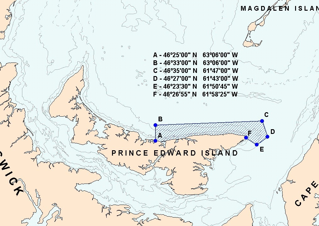
Note: These reference points are based on the geodesic system North American Datum 1927 (NAD27).
Chart 2
Closure of the commercial spring fishery in a portion of HFA 16E near Cape Egmont
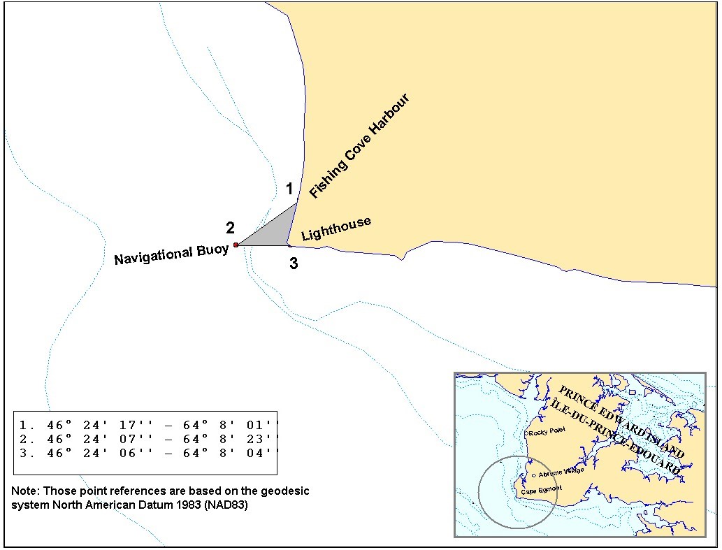
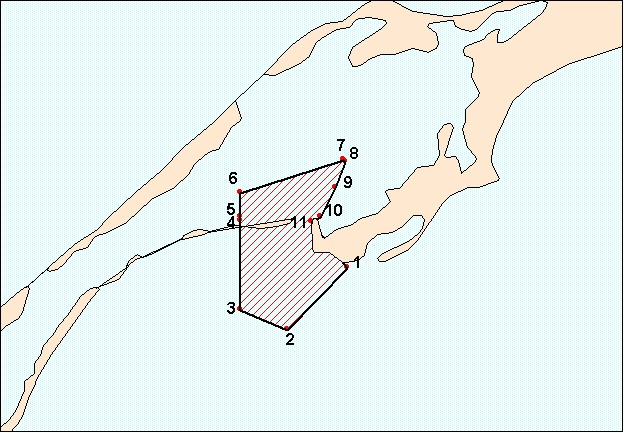
Chart 3
Exclusion zone in the Grande-Entrée Channel in HFA 16D
- 47° 32' 30'' N - 61° 32' 39'' W
- 47° 31' 16'' N - 61° 34' 26'' W
- 47° 31' 40'' N - 61° 35' 48'' W
- 47° 33' 26'' N - 61° 35' 48'' W
- 47° 33' 31'' N - 61° 35' 48'' W
- 47° 34' 00'' N - 61° 35' 48'' W
- 47° 34' 39'' N - 61° 32' 46'' W
- 47° 34' 37'' N - 61° 32' 43'' W
- 47° 34' 06'' N - 61° 33' 00'' W
- 47° 33' 31'' N - 61° 33' 27'' W
- 47° 33' 25'' N - 61° 33' 43'' W
Exclusion zone in the Havre Aubert harbour in HFA 16D
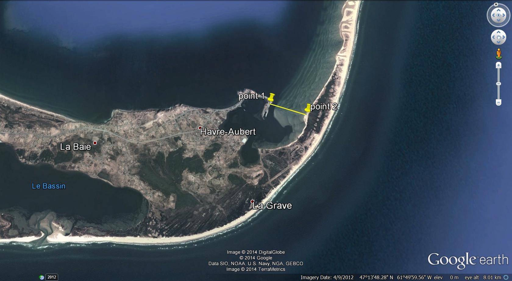
- 47° 14' 09.20'' N - 61° 49' 40.10'' W
- 47° 13' 57.30'' N - 61° 49' 09.90'' W
Chart 4
Closure of the spring commercial fishery on spawning beds in New Mills, Carleton and St-Omer in HFA 16B (Grey zones)
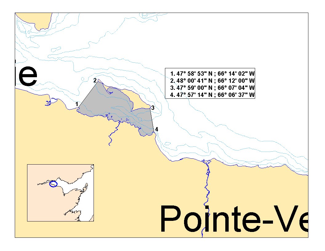
Note: These reference points are based on the geodesic system North American Datum 1983 (NAD83).
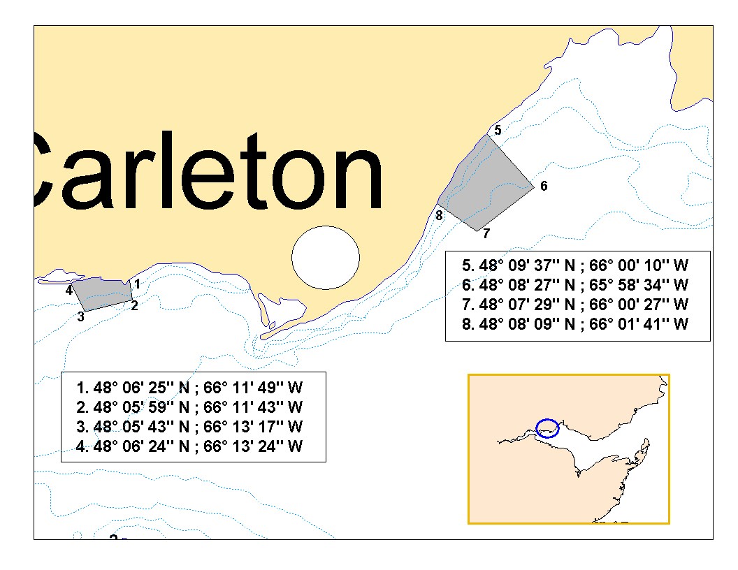
Chart 5
Closure of the spring commercial fishery on a spawning bed near Point Escuminac (N.B.) in HFA 16C (Grey zone)
Note: These reference points are based on the geodesic system North American Datum 1983 (NAD83).
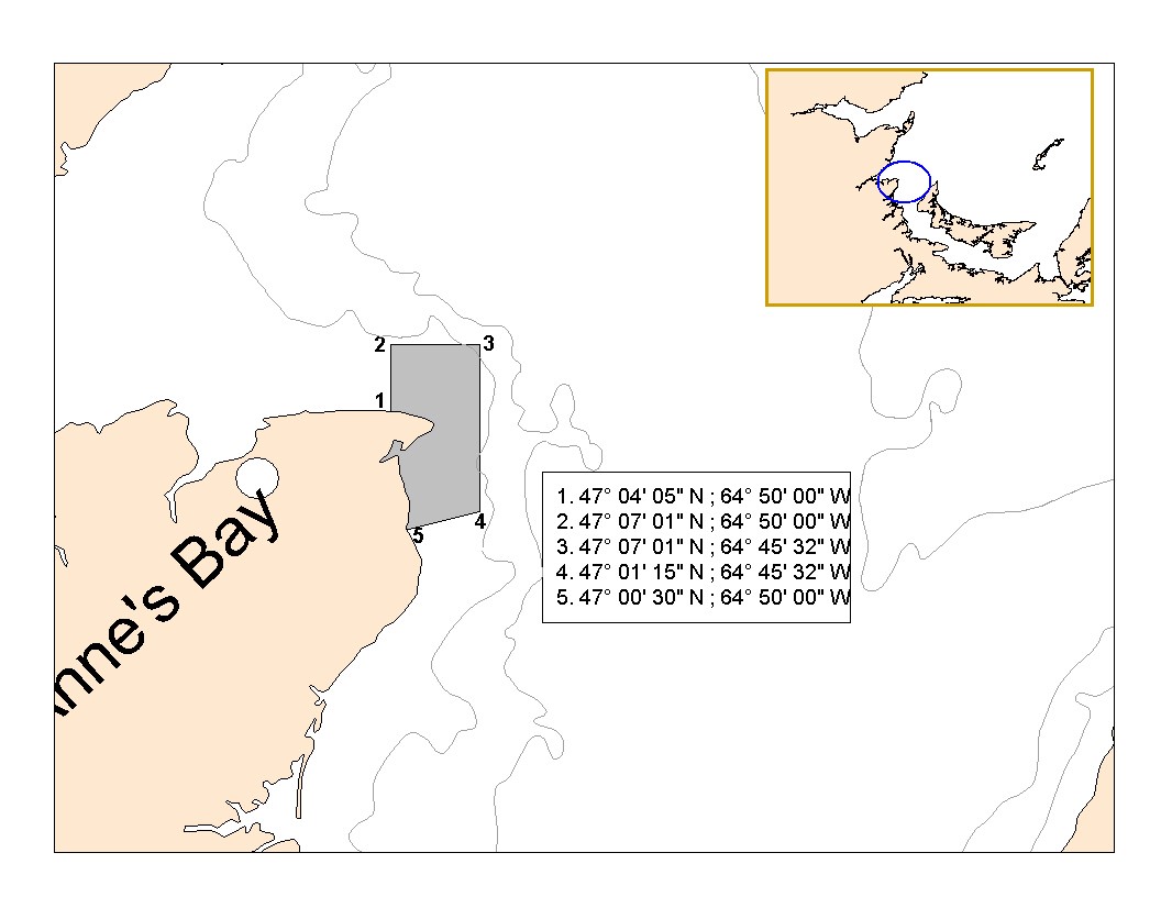
Chart 6
Closure of the spring commercial fishery on a spawning bed near Cape Jourimain (N.B.) in HFA 16E (Grey zone)

Note: These reference points are based on the geodesic system North American Datum 1983 (NAD83).
Annex 1
Spring herring reserve distribution rules for the 2021 Sharing Plan
- Each HFA will maintain their existing quota share at the end of the sharing plan.
- Establishment of a 123.56 t reserve by removing 100 t from the inshore fleet total quota, and by also removing allocation, according to actual shares, of 0.93 t (HFA 16A), 8.7 t (HFA 16C), 12.13 t (HFA 16D) and 1.8 t (HFA 16F) bringing those HFAs to their 2007 catch level. No allocation was removed from HFA 16G since their allocation, after deduction of 100 t from the inshore fleet total quota, was less than the 2007 catch level.
- All HFAs will have access to the reserve when their initial allocation has been caught before June 1.
- On June 1, uncaught initial allocations and remaining reserve are transferred to the June 1-30 quota. Starting on June 1, any fisher may fish against the HFAs 16A to 16G, June 1-30 quota.
- The spring inshore herring fishery will be closed if the total inshore quota is caught.
Spring – Share scenario based on establishment of a reserve
| HFA | Current share | Quota based on current shares (Column A) | Allocation after deducting 100 t | Quota after deduction from HFA 16A, C, D, F, G & Initial allocation | Rules for accessing the reserve (123.56 t) |
|---|---|---|---|---|---|
| 16A | 1.03% | 3.96 | 2.93 | 2 | Total catches prior to May 31 no higher than current shares (column A - 3.96 t) |
| 16B | 6.36% | 24.45 | 18.09 | 18.09 | 25 t increments up to a total of 68.09 t |
| 16C | 32.60% | 125.31 | 92.71 | 84 | 25 t increments to the level of current shares (column A - 125.31 t) |
| 16D | 9.54% | 36.67 | 27.13 | 15 | 25 t increments to the level of current shares (column A - 36.67 t) |
| 16E | 40.56% | 155.91 | 115.34 | 115.34 | 25 t increments to a total of 165.34 t |
| 16F | 2.39% | 9.19 | 6.80 | 5 | Total catches prior to May 31 no higher than current shares (column A - 9.19 t) |
| 16G | 2.01% | 7.73 | 5.72 | 5.72 | Total catches prior to May 31 no higher than current shares (column A - 7.73 t) |
| 16A-G (June 1-30 ) | 5.50% | 21.14 | 15.64 | 15.64 | 100% of remaining reserve and unused area allocations after June 1 |
| 17 | 5 | 5 | 5 | ||
| Total | 100% | 384.36 | 284.36 | 260.79 |
Annex 2
Large purse seine fleet fishery on the limit of 4T (“Edge” region)
- All Gulf large purse seine licence holders are authorized to conduct fishing activities during spring on the “Edge” of 4T (Chart 7). This herring fishery targets the fall spawner component.
- The large purse seine fleet is authorized to fish their fall herring quota along the “Edge” in 4T during the spring season (May-June). Catches will be counted towards this quota.
- All vessels must be equipped with an operational Vessel Monitoring System (VMS) during fishing activities.
- There is a 20% at sea observer coverage during the spring fishery along the Laurentian channel near the limit of 4T (“Edge” region).
- The maximum by-catch authorized of mackerel or capelin is set at 10% of the directed species. The maximum by-catch authorized of groundfish is set at 5% of the directed species. Monitoring and sampling for by-catch species will be conducted at sea and may be verified at dockside by fishery officers.
- A small fish protocol is in place to control the capture of juvenile herring during the purse seine fishery with a 100% dockside monitoring. The small fish protocol reduces the remaining available quota according to the percentage of herring smaller than 23.5 cm (fork length) in the catch.
- A scientific protocol has been developed to verify the spawning component of the herring caught. The proportion of spring and fall spawners in the catch will be determined by DFO. If at any time the amount of spring spawners in the catch reaches the spring allocation, the purse seine fishery will be closed until July 1.
Chart 7
Area where the large purse seine fleet « Edge » fishery will occur (area in blue).
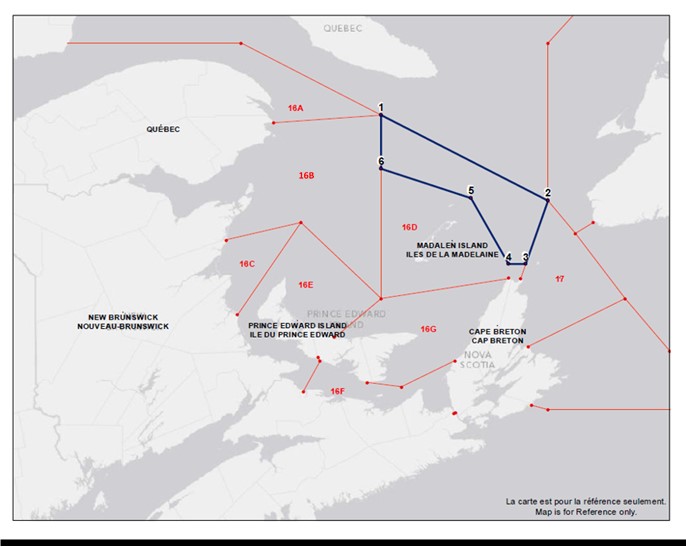
| Points | Latitude North | Longitude West |
|---|---|---|
| 1 | 48°42’00”N | 62°32’00”W |
| 2 | 47°50’00”N | 60°00’00”W |
| 3 | 47°11’06”N | 60°20’07”W |
| 4 | 47°11’06”N | 60°35’52”W |
| 5 | 47°51’33”N | 61°10’07”W |
| 6 | 48°09’33”N | 62°32’02”W |
| 1 | 48°42’00”N | 62°32’00”W |
Note: These reference points are based on the geodesic system North American Datum 1927 (NAD27).
- Date modified: