
Aquatic species at risk map
We've compiled critical habitat and distribution data for aquatic species listed under the Species at Risk Act (SARA). This map is intended to provide an overview of the distribution of aquatic species at risk and the presence of their critical habitat within Canadian waters. The official source of information is the Species at Risk Public Registry.
This mapping tool is for general guidance only. Mapped representations of waterbodies and watercourses are based on authoritative provincial geospatial products, guidance and standards. Due to the nature of dynamic systems and the resolution/accuracy of these data sets, areas within which critical habitat is found as displayed on the mapping tool may not align exactly with natural watercourses. If discrepancies occur, refer to the relevant species recovery strategy and/or action plan for additional information on critical habitat. If additional guidance is required please contact the Fish and Fish Habitat Protection Program.
If you encounter an aquatic species at risk in an area that isn't currently mapped, please notify your regional Fish and Fish Habitat Protection Program office to ensure that you're compliant with SARA.
Information and legend
Using the map
Click this button for a list of species that can be used offline.
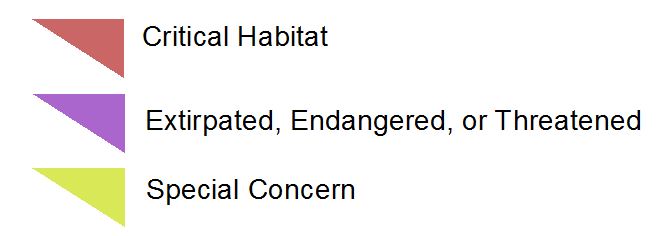
Legend
One or more aquatic species listed under the Species at Risk Act are found (or potentially found) within the coloured areas.
Access data and metadata
These datasets are available on the Open Government website:
- Date modified: