
Coastal Environmental Baseline Program projects in the St. Lawrence Estuary, Quebec
The Estuary and Gulf of St. Lawrence represents one of the largest and most productive estuarine/marine ecosystems in the world but is exposed to a wide variety of human pressures. This area was therefore one of the first marine ecosystems in Canada designated as a Large Ocean Management Area. The Gulf of St. Lawrence Integrated Management project provides an overarching management structure to govern all Integrated Coastal Zone Management plans developed within the ecosystem, including establishment of Marine Protected Areas.
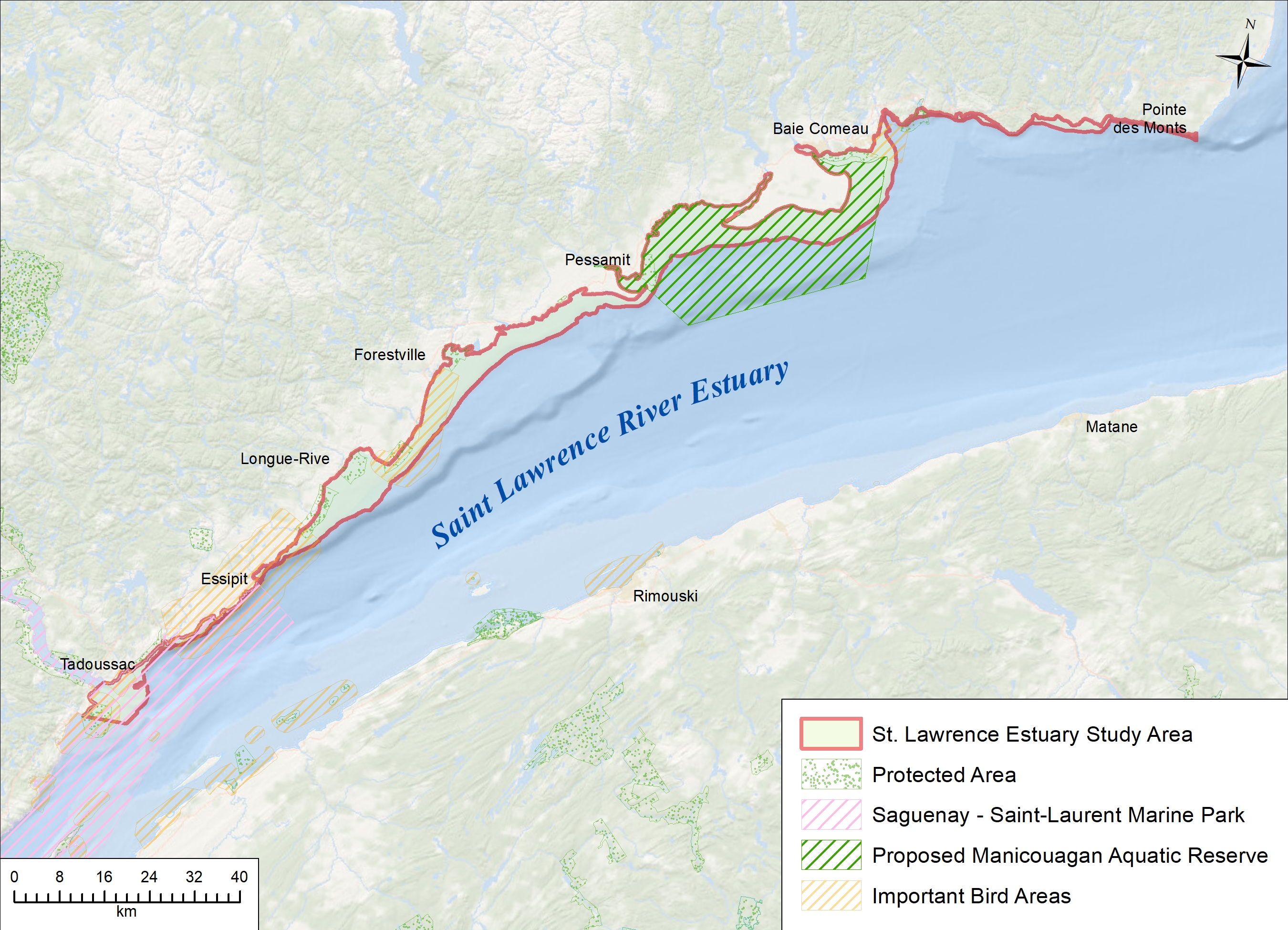
Map of the Lower St. Lawrence Estuary, Quebec.

| Description | Timeframe | Funding amount |
Characterization of benthic macrofauna in rocky shoreline areas and awareness of the state of marine ecosystems in the Haute-Côte-Nord and Manicouagan regionsFunding recipient: Explos-Nature Project summary: Explos-Nature will collect baseline data to characterize the state of aquatic ecosystems in rocky shoreline areas in the Haute-Côte-Nord and Manicouagan regions. The study will focus on the abundance and distribution of benthic macrofauna while characterizing habitats and collecting environmental data, such as water temperature, conductivity, turbidity and salinity. The project will also aim to raise public awareness of the state of aquatic ecosystem health and scientific data collection methods. |
2018-2022 | $536,577 |
Characterization of the abundance, richness and diversity of fish in coastal environments using non-extractive methodsFunding recipient: Université du Québec à Rimouski Project summary: This project will assess underwater camera video recordings to develop indices of fish species richness, diversity and spatio-temporal variations. These indices will be calibrated to St. Lawrence Estuary coastal habitats and validated by surveys. |
2018-2022 | $92,000 |
Hyperspectral remote sensing of shallow coastal waters using the WISE sensorFunding recipient: Université du Quebec à Rimouski Project summary: This project aims to acquire data on shallow coastal ecosystems through hyperspectral remote sensing. Researchers will develop skills for mapping coastal habitats using new technologies. They will fly an aircraft-mounted WISE sensor over the Manicouagan Peninsula on the St. Lawrence Estuary to map coastal habitats (aquatic vegetation and substrate), improving research tools and obtaining data needed to support decision-making for marine ecosystem management. |
2018-2022 | $194,920 |
Temporal dynamics of intertidal macroalgal productivity in the St. LawrenceFunding recipient: Université du Québec à Chicoutimi Project summary: This project will provide an in-depth understanding of the relationship between the presence, distribution and health of intertidal macroalgae (seaweed) in the study area. It will quantify past storm and ice abrasion events to identify possible relationships between disturbances and macroalgal baselines (seasonal, annual and decadal trends). Sensitive areas will be better identified, and the resilience of the algal canopy to disturbances will be more clearly characterized. The project will also explore new techniques for remote sensing of macroalgae and provide a valuable tool for monitoring coastal marine ecosystems. |
2018-2022 | $99,963 |
Characterization of important coastal habitats on the north shore of the St. Lawrence EstuaryFunding recipient: Comité Zone d’Intervention Prioritaire de la Rive Nord de l’Estuaire (Comité ZIP) Project summary: This study will improve understanding of aquatic environments by characterizing the biological and abiotic components of different wetlands in the St. Lawrence Estuary. The characterization of these coastal habitats and the new information acquired will shed light on particularly sensitive biological aspects associated with the different marshes. |
2018-2022 | $131,825 |
Characterization of the seabed between Tadoussac and Baie-Comeau based on LiDAR data from the Canadian Hydrographic ServiceFunding recipient: Centre interdisciplinaire de développement en cartographie des océans (CIDCO) Project summary: Researchers will analyze LiDAR (light detection and ranging) data provided by the Canadian Hydrographic Service to characterize the ecosystem between Tadoussac and Pointe-des-Monts. The study will focus on physical features and other research parameters as well as direct observation to categorize different benthic habitat types. |
2018-2022 | $541,084 |
Assessment of the bivalve biomass around the community of Pessamit; Assessment of the green sea urchin biomass at the mouth of the Saguenay FjordFunding recipient: Agence Mamu Innu Kaikusseht (AMIK) Project summary: This project conducts a baseline biomass survey of bivalve species (softshell clams, razor clams, macoma, etc.). Using established scientific protocols, community members collect data on bivalve species, sediment quality and other parameters. To establish a population baseline, community members also conduct biomass surveys on green sea urchin in the mouth of the Saguenay Fjord. The data collected on shellfish beds and green sea urchin populations is important to inform resource management decisions. |
2019-2020 | $85,603 |
Assessment of the quality of the living environment of the Betsiamites estuaryFunding recipient: Agence Mamu Innu Kaikusseht (AMIK) Project summary:This project collects baseline data on environmental conditions. Water and sediment samples are analyzed for:
Next, a field study on the aquatic organisms living in the environment is conducted. The data collected under this project contributes to a baseline understanding of pollutants and their potential impacts on the ecosystem. |
2021-2022 | $55,000 |
Biodiversity, richness and abundance patterns of the zooplankton in the shallow coastal zone of the Ecologically and Biologically Significant Marine Area of the lower St. Lawrence EstuaryFunding recipient: Université du Québec à Rimouski Project summary: This project collects baseline data on the distribution patterns of zooplankton in the shoreline and coastal zones of the lower St. Lawrence Estuary. Vessel-based trawl surveys are carried out during different seasons to inform zooplankton’s abundance and biodiversity. The data collected contributes to a baseline understanding of ecosystem health, which will be critical to detect changes in the face of climate change and human activity. |
2019-2022 | $455,210 |
Characterization of Atlantic salmon in the tributaries near the community of EssipitFunding recipient: Agence Mamu Innu Kaikusseht (AMIK) Project summary: This project studies the Atlantic salmon population in the Essipit tributaries, including their migratory patterns. Atlantic salmon have cultural, spiritual and dietary importance to Indigenous communities. In the field, salmon are collected and retained for counting and identification. Then they are implanted with movement trackers and released. The data collected provides insight into possible factors affecting salmon population numbers and migration. It also contributes to a broader baseline understanding of the local ecosystem. |
2022-2023 | $55,000 |
Characterization of important coastal habitats to aid conservation efforts: Establishing a baseline of coastal marshes and eelgrass beds on the north shore of the Lower EstuaryFunding recipient: Comité Zone d’Intervention Prioritaire de la Rive Nord de l’Estuaire Project summary: Building on a previous project, this project collects baseline data on important salt marshes (wetlands). This project focuses on the Hickey salt marsh. Field surveys are conducted to identify biotic and abiotic conditions, including species presence, abundance and geomorphological data. The data collected contributes to a baseline understanding of these ecosystems, which will be important to detect environmental change. |
2022-23 | $74,882 |
Characterization of the diversity and abundance of pelagic and benthic organisms in the coastal environments of the Lower St. Lawrence Estuary using baited underwater video camerasFunding recipient: Université du Québec à Rimouski Project summary: This project gathers baseline data on the richness and diversity of aquatic organisms by analyzing video collected with underwater cameras. The data contributes to a baseline understanding of pelagic and groundfish habitats and communities and associated environmental conditions. This information could help assess the impacts of future environmental change. |
2022-23 | $40,710 |
Characterization of the salt marsh of the Betsiamites River estuaryFunding recipient: Agence Mamu Innu Kaikusseht (AMIK) Project summary:This project collects baseline data on the salt marshes of the Betsiamites river estuary, an important habitat for the overall health of the Lower St. Lawrence Estuary ecosystem. In collaboration with the Comité Zone Prioritaire de la Rive Nord de l’Estuaire (Comité ZIP), AMIK conducts a field study to document the biotic and abiotic characteristics of these wetlands. |
2020-2021 | $75,000 |
Estimation and extrapolation of intertidal macroalgal biomass and productivity in the St. LawrenceFunding recipient: Université du Québec à Chicoutimi Project summary: Building on a previous project, this project generates baseline data on the changes in biomass of macroalgae (seaweed) in the Lower St. Lawrence River estuary. Data is generated by combining previously-harvested algae data with aerial drone footage taken at the time of harvest. This baseline data will be important for detecting future ecosystem change in the estuary. |
2022-23 | $26,968 |
Increasing efforts to characterize rocky environments with scuba diving between Tadoussac and Pointe-des-MontsFunding recipient: Explos-Nature Project summary: Building on a previous project, this project collects environmental data on benthic macrofauna (e.g. starfish) and subtidal rock habitats on the Upper North Shore (Lower St. Lawrence Estuary) and in the Manicouagan Peninsula. Divers conduct visual underwater transects, a survey to count and identify macrofauna. The project also delivers educational programs, such as a virtual activity where students identify organisms from the videos collected. This baseline data will be important to inform scientific research in the area and to inform environmental management decisions in the face of environmental change. |
2022-2023 | $136,007 |
Mapping the biomass and microphytobenthic assemblages of the intertidal zone of the Manicouagan Peninsula using airborne hyperspectral imageryFunding recipient: Université du Québec à Rimouski Project summary: Building on a previous project, this project collects baseline data on shallow coastal ecosystems in the Lower St. Lawrence Estuary. Remote sensing technologies are used to detect and monitor the physical characteristics of selected areas by measuring their reflected and emitted radiation. This project aims to identify, quantify and map intertidal and shoreline vegetation biomass (e.g. seaweed and seagrass beds) to better understand its role in storing carbon in coastal habitats. |
2022-2023 | $55,430 |
New methods for collecting data and underwater image processing for the characterization of marine habitats and the identification of species on the north shore of the St. Lawrence Estuary between Tadoussac and Pointe-des-MontsFunding recipient: Centre Interdisciplinaire de Développement en Cartographie des Océans (CIDCO) Project summary: Building on a previous project, this project uses LiDAR (light detection and ranging) remote sensing to learn more about the benthic marine ecosystem. LiDAR analysis uses laser technology to measure the distance to a target, and can characterize the seafloor of large coastal areas in a short amount of time. The study focuses on characteristics, like physical features, and uses direct observation to categorize different habitats at the bottom of the estuary. |
2022-23 | $115,304 |
Pelagic secondary producers in coastal habitats of the Lower St. Lawrence Estuary: taxonomic and functional diversityFunding recipient: Université du Québec à Rimouski Project summary: This project builds on a previous project studying the biodiversity, composition and distribution of zooplankton, particularly for the copepod community, in the shoreline and coastal zones of the Lower St. Lawrence Estuary. For this project, sampling is expanded to new areas in order to obtain baseline data on a broader scale within the estuary. The data collected can help inform future environmental impacts, including impacts of climate change, on the Lower St. Lawrence Estuary ecosystem. |
2022-2023 | $150,995 |
- Date modified: