
Effects of the Haida and Sitka eddies
Learn how the Haida and Sitka eddies affect sea surface and plankton in the Gulf of Alaska.
On this page
Sea surface height maps
We used TOPEX/Poseidon and ERS-2 satellite altimeters to measure sea surface elevations. These images show:
- eddies
- depressions
- high sea surface
Sea surface height maps (ZIP file, 2.6 MB).
The original data were processed by the Colorado Center for Astrodynamics Research. We've added labels to show the drift of Haida and Sitka eddies between February 1998 and September 2005.
In the following diagram, regions between blue horizontal lines denote depressions. Eddies appear as red arrows.
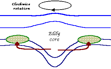
Diagram showing nutrient transport from an eddy to surrounding waters.
Plankton
Plankton abundance is usually low in September in the Gulf of Alaska. This is because the ocean has too little light, or too few nutrients, to allow plankton to grow. In the spring, plankton will use up any nutrients found where light levels are high (within 30 to 40 metres of the surface).
In the eddy core, the spinning motion of the eddy pushes nutrient-rich waters from the coast of North America down to depths where little light penetrates. However, outside the core, at depths between 40 and 60 metres, light and nutrient levels can support 2 to 3 times more plankton than normal in September.
We measured plankton in September 1998 by lowering a transmissometer through Haida-1998. Our measurements showed low transmission and more plankton between 40 and 60 metres below the ocean surface. However, this was only in the outer rings of the eddy at 50 to 100 kilometres away from the core.
We found less plankton in the centre of this eddy and in the surrounding ocean.
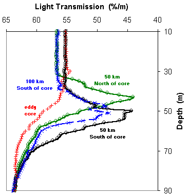
Diagram showing the effect of eddies on plankton in the Gulf of Alaska.
Related links
- Date modified: