Monitoring Southern BC Coastal Waters
The Strait of Georgia is a large semi-enclosed basin on the southern coast of British Columbia. The main connection to the Pacific is to the south, through Juan de Fuca Strait. Abundant freshwater discharge, mainly from the Fraser River, forces an estuarine exchange with oceanic shelf water. The resulting circulation is modulated by tides and winds. Both the coastal wind stress and the flux of freshwater are subject to strong seasonal modulations, producing a marked seasonal cycle in the water properties of the region.
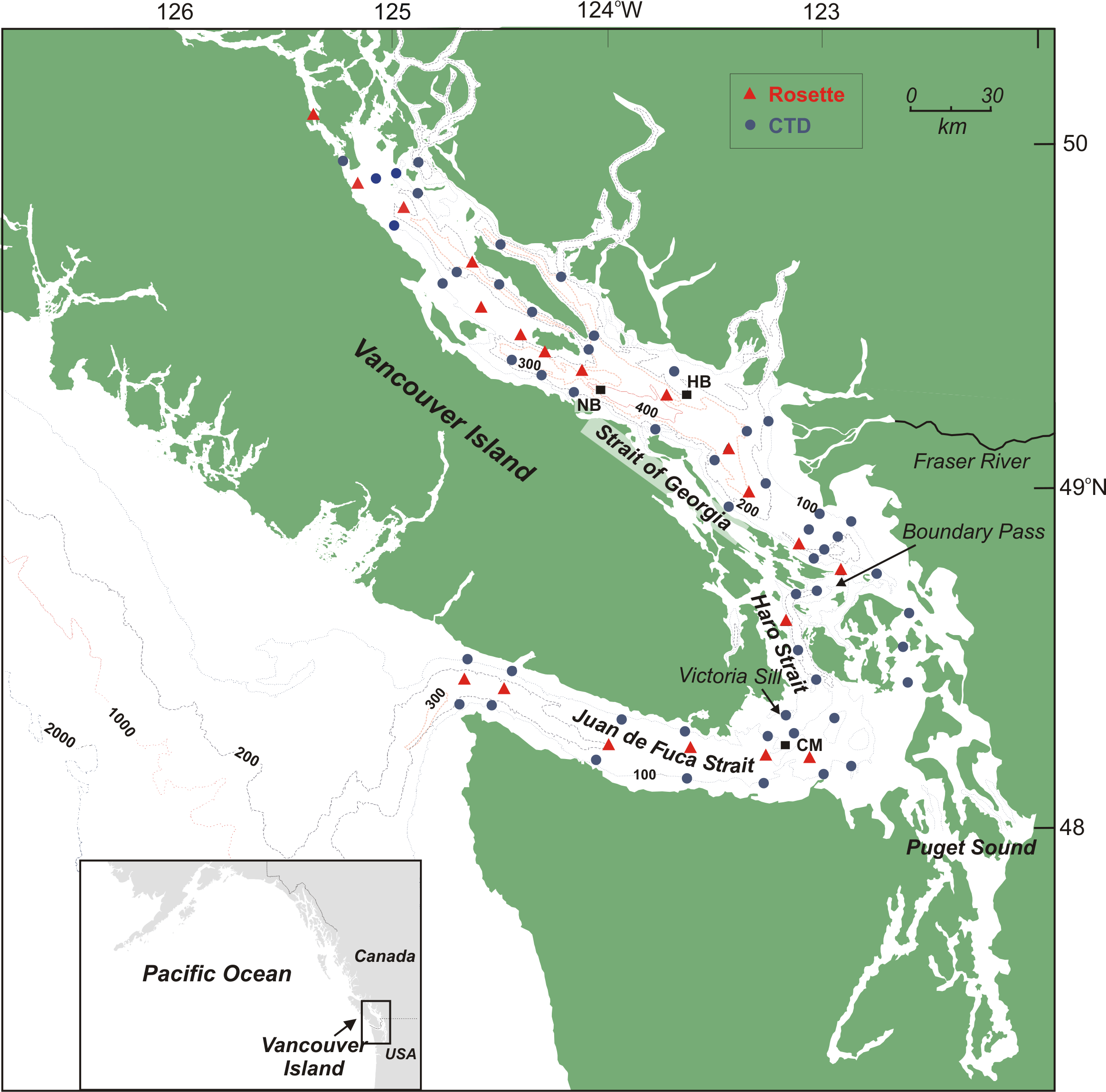
Since 1999, a series of about 73 stations, extending from the mouth of Juan de Fuca Strait up to the northern end of the Strait of Georgia, are visited seasonally. Most of the data used in this study have been collected with the CCGS Vector. CTD profiles are taken at each station and water samples collected at a subset of stations.
Each year, four surveys are done during periods of (1) low winter discharge (December), (2) early freshet (April), (3) peak freshet (June), and (4) end of freshet period (September). In addition, longer term historical data sets collected in the central Strait of Georgia and in Juan de Fuca Strait are also used to help determine the observed seasonal variability of the system.
Within the Strait of Georgia, the central basin reaches large depth of over 400 m. The circulation within this deep basin is limited due to the presence of shallow sills on both ends of the Strait. However, occasionally, the deep water is renewed by deep water intrusions entering the strait from the sill areas.
Some early results from the program are described in Water properties in the Straits of Georgia and Juan de Fuca.
For more information on the sampling program, contact Diane Masson.
Data Collection
Several parameters are measured in order to characterize the water column and determine its origin and progression. Temperature and salinity are two important properties because they determine the water density. In the present study, these two oceanographic parameters are measured at each station using a Conductivity Temperature and Depth (CTD) probe. We also take water samples at stations along the main axis of the Strait from which we extract other water properties such as dissolved oxygen and nutrients.
During this study, we routinely measure:
- temperature in ºC
- salinity in psu (practical salinity units)
- volume of dissolved oxygen in ml/l
- nitrate (NO3)
- silicate (Si)
- phosphate (PO4) in µmol/l
All the instruments are installed on a metal frame, a rosette, and are lowered into the water at the same time. The pressure sensor of the CTD probe transmits its depth as it is lowered. An electronic cable links the probe to the surface. The depth sounder allows us to track the position of the system relative to the bottom using a transducer installed on the metal frame. The temperature and salinity are recorded during the descent down to the bottom. The rosette is then brought back up, either in a continuous fashion or stopping at pre-defined depths to obtain water samples by closing a bottle using a signal from the electronic cable.
The data is stored on a computer onboard the ship. Further data processing and analysis is performed in the following months at the Institute.
Fraser River
A number of rivers and small creeks discharge a large amount of freshwater into the Southern BC coastal waters. The most important source of freshwater is the Fraser River.
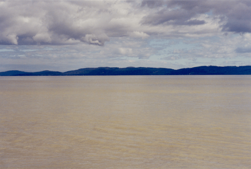
The Fraser River discharges into the Strait of Georgia near the city of Vancouver. The fresh water flows through 2 main arms of the river, with 87% of the flow in the south arm. The river flow varies significantly through the year, ranging from winter discharge rates as low as 300 m3s-1 to a maximum of 10000 m3s-1 during spring freshet. The picture on the right shows the murky water associated with the plume of the Fraser River. The freshwater entering the strait forms a thin fresh layer at the surface of the ocean easily identified by the brownish color caused by the heavy sediment load.
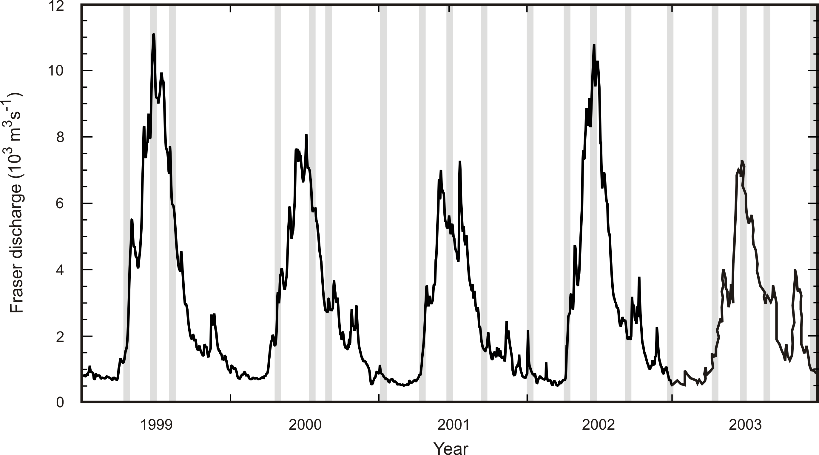
Each year, the surveys are timed in relation with the freshwater seasonal cycle, with sampling preferentially done during periods of (1) low winter discharge, (2) early freshet (April), (3) peak freshet (early summer), and (4) end of freshet period (early fall). The 19 surveys completed over the last five years are indicated by the grey lines in the plot on the left.
The river discharge reaches maximum values in early summer (June) due to snowmelt in the mountains. The freshet period lasts for about 3 months. There is also significant year to year variability to the flow as can be seen in the above figure. In years of low winter snow cover, such as 2001, the peak discharge reaches values of about 6000 m3s-1. On the other hand, during the spring freshet following a winter of important snow fall ( such as 1999), the flow can reach large peak values of up to 12000 m3s-1.
Deep Water Renewal Events
The Strait of Georgia is connected with the open ocean through narrow constrictions and shallow sills. The central Strait is relatively deep (highlighted in blue in the figure on the right), reaching water depth of more than 400 m, well below the depth of the sill at Boundary Pass. The deep water mass is then isolated from the ocean shelf waters for most of the year. However, deep water intrusions occasionally penetrate the deep basin, displacing the ambient water mass. These events are caused by the intrusion of dense water that flows over the sill at Boundary Pass, generating a gravity current that flows along the bottom, into the deep basin. The figure on the right shows the positions of four current meter moorings, AS01, AS02, AS03, and AS04, along with the long term hydrographic station of Nanoose Bay, NB. Data collected at these stations were used to study deep water renewal events.
The deep water of the Strait are renewed through discrete deep water renewal (DWR) events during which dense water flows over the sills and into the interior basin. The events can be classified into two categories which comprise the annual cycle: late winter intrusions bring cold, oxygen rich water, and late summer events bring warm, saline, low oxygen water. There are also important interannual variations in the deep water renewal seasons. The figure on the left shows how the warm deep water present in April 1999 had been displaced by colder water brought in by the cold spring intrusions.
Gravity Current
Deep water replenishment occurs episodically in the form of discrete intrusions with characteristics similar to those of bottom gravity currents. The passage of an intrusion is associated with an increase in salinity, density and velocity. In the case of temperature, the dense pulse reaches the deep layer as a relatively warm (cold) pulse in the fall (spring). Each intrusion lasts about 10 days and displays the shape characteristic of a gravity current with a sharp forward front at the head followed by a more diffuse tail.
Annual Cycle
The two deep water renewal seasons determine the annual cycle of the deep water in the Strait of Georgia. It is characterized by a saw tooth cycle for the salinity with maximum salinity values in the fall, and a step-like pattern for temperature with a low value plateau in summer and higher values in winter. The timing of the two DWR seasons (spring and late summer) is explained in terms of the overlap of the coastal upwelling season and of the Fraser River freshet. Twice through the year, in the spring and at the end of the summer, relatively high surface salinity combine with dense deep return flow to form water near the sill dense enough to sink into the deep basin. The yellow lines on the figure on the right indicate 6 DWR events measured in 1989/1990. Note the different density scale for AS01.
Interannual Variations
Year to year variability in the timing and intensity of both the upwelling season and the river freshet leads to important inter-annual variations in the deep water renewal seasons. For example, during the year following the onset of a strong El Niño, the temperature at the bottom of the strait does not show the typical spring cooling. The likely reason for this is the presence of anomalously warm water on the shelf. Following such a summer during which the water stays relatively warm, the subsequent fall DWR season raises the bottom temperature to relatively high values (as present in April 1999).
Fortnightly Tidal Forcing
Each deep water renewal event occurs following a neap tide, when the density near the bottom of the sills reach a maximum. Also, the deep intrusions occur monthly, after every other neap tide. This appears to be due to the fact that the time response of the density field within the estuary is longer that the fortnightly period. It takes two consecutive neap tides for the density at the sill to reach high enough values after the flushing of dense water by the previous event. In the figure on the right, the DWR events (indicated in yellow) are time intervals of large density recorded at AS02.
Masson, D. 2002. Deep water renewal in the Strait of Georgia. Estuarine, Coastal and Shelf Science 54:115-126.
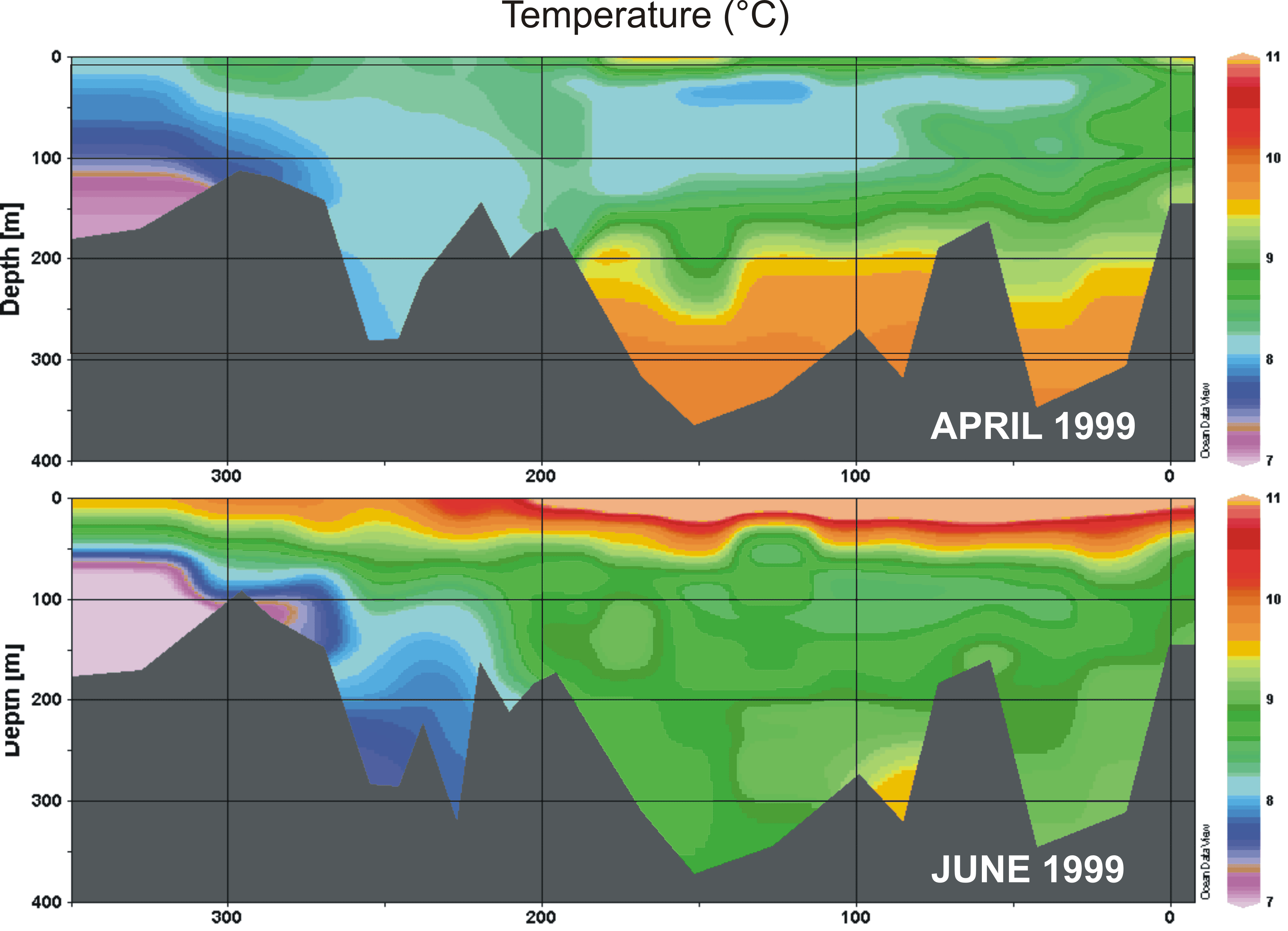
Contours of temperature measured at a series of stations located on an along-strait section, showing warm deep water in April replaced by colder water in June 1999.
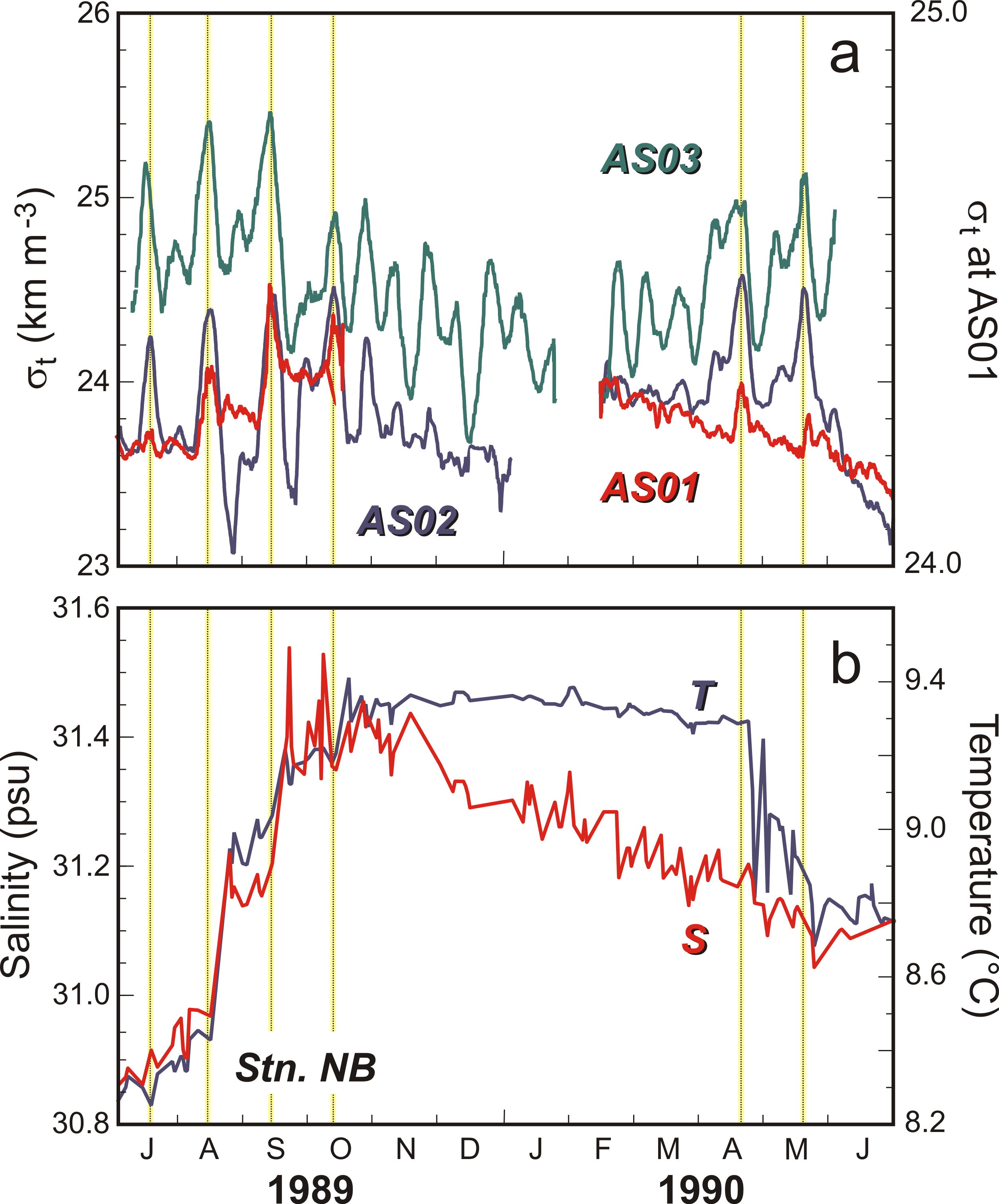
The top panel (a) gives a time series of the bottom water density at AS02, AS03, and AS01, and the bottom panel (b) gives the temperature and salinity measured near the bottom at NB
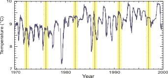
Bottom temperature at the NB station. The yellow lines indicate the beginning of the main El Niño events.
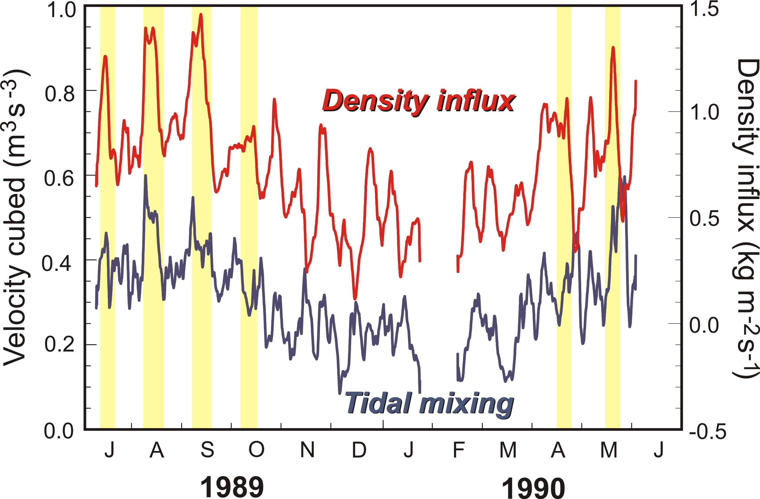
Mixture intensity due to Boundary Pass Low Pass filtered tide (AS03) represented by the cubic velocity and density influx over the pass.
- Date modified:
