
Musquash Estuary Marine Protected Area (MPA) annual report 2024
On this page
- At-a-glance
- Conservation objectives
- Management and governance
- Feature creatures
- Research and monitoring
- Collaborations and partnerships
- In the spotlight: benefits
- Surveillance and enforcement
- Outreach and engagement
At-a-glance
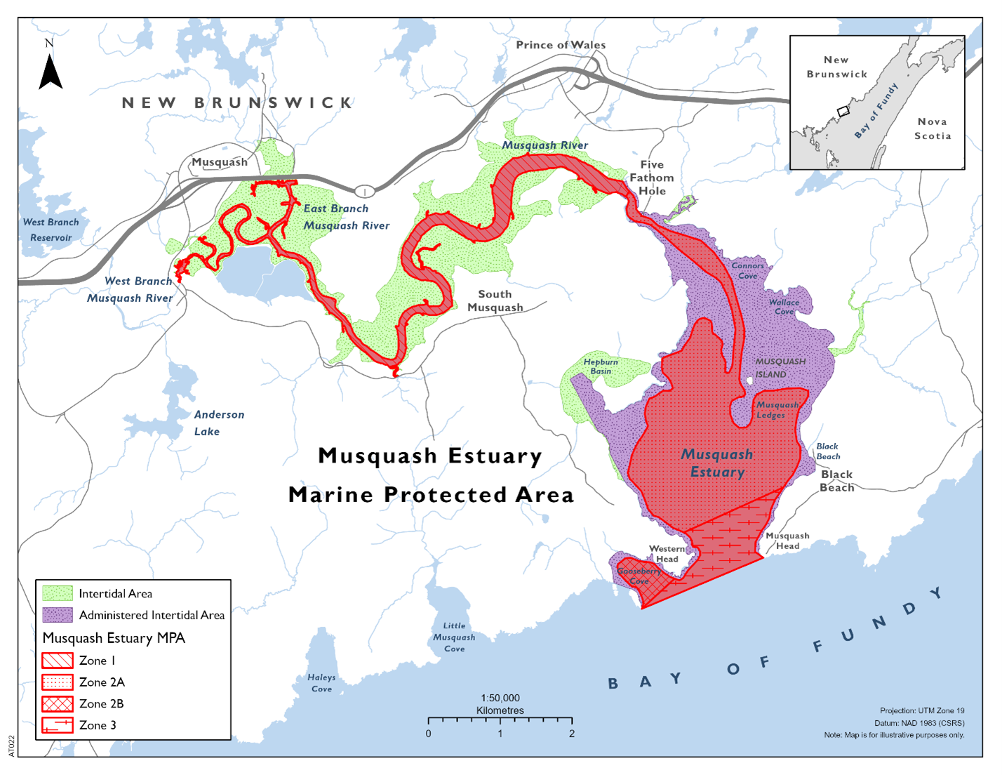
Map of Musquash Estuary Marine Protected Area.
Date of designation:
2006
Size:
7.4 km2
Contribution towards the marine conservation targets:
< 0.01%
Location:
This MPA is located in Southwest New Brunswick (NB), within the Bay of Fundy Bioregion; Atlantic Ocean.
Managed by:
Fisheries and Oceans Canada (DFO)
Acknowledgement:
Musquash Estuary is located within Wabanakik, the unceded homelands of the Wolastoqey, Mi’kmaq and Peskotomuhkati peoples.
Zones:
There are several management zones:
- Zone 1 - The Upper estuary, which includes the lower reach of Musquash River surrounded by saltmarsh
- Zone 2a - Middle to lower estuary, where fresh and saltwater mix
- Zone 2b - Gooseberry Cove
- Zone 3 - Lower estuary, which is bordered by cliffs and opens to the Bay of Fundy
Conservation objectives
To ensure no unacceptable reduction or human-caused modification to:
- productivity so that each component (primary, community, population) is functioning in the ecosystem (for example, by maintaining the abundance and health of harvested species)
- biodiversity by maintaining the diversity of individual species, communities and populations within the different ecotypes
- habitat in order to safeguard the physical and chemical properties of the ecosystem by maintaining water and sediment quality
Management and governance
The Musquash Estuary MPA management plan (2017) continued to guide ongoing management and governance of the MPA in 2024.
DFO manages the MPA in collaboration with the Musquash Advisory Committee (MAC). In 2024, the MAC held 2 meetings and members included representatives from:
- First Nations
- federal and provincial governments
- local communities
- environmental non-government organizations (eNGOs)
- universities
At the Spring MAC meeting in 2024, concerns were raised about a collapsed culvert along a former railbed that crosses a small tributary of the west branch Musquash River. This appears to be a full barrier that is impeding fish passage and causing floods and washouts. The culvert is located within 10-15m of Zone 1. An assessment is underway by Eastern Charlotte Waterways to provide recommendations for remediation.
In 2024, efforts to monitor and manage invasive species in the MPA were successful. Two small patches of Phragmites, an invasive tall grass, were assessed by Dr. Myriam Barbeau’s lab at the University of New Brunswick (UNB) while eNGOs such as Ducks Unlimited Canada (DUC) and Eastern Charlotte Waterways led removal efforts.
In addition to the removal of invasive species, sections of a berm were successfully removed and restoration efforts are now in progress. Several freshwater wetlands lie adjacent to the MPA which were originally salt marshes that were diked to create agricultural lands. Fields were flooded for waterfowl during the 1980s. In January 2024, after several years of UNB monitoring, DUC was approved to restore an impoundment. DUC breached the berm, restored tidal flow and began the re-naturalization process.
While no new contribution agreements were signed for ongoing support of the MPA in 2024, DFO had ongoing contribution agreements with 3 eNGOs, the:
- Nature Conservancy of Canada (NCC)
- Eastern Charlotte Waterways (ECW)
- Atlantic Coastal Action Program (ACAP) Saint John
In 2024, 4 approvals were issued for activities occurring in the MPA, including:
- drone surveys to monitor habitat changes
- water sampling for environmental DNA (eDNA) analysis
- collection of benthic invertebrates, fish and sediment for stable isotope analysis supporting diet and food-web studies
- mudflat surveys of sediment pH and invertebrates
In addition, 8 multiyear approvals that were issued in previous years for several activities continued in 2024, though not all approved projects resulted in activities. Some of the activities that did occur in 2024 included:
- acoustic tracking of fish and other broad aquaculture baseline studies
- Coastal Environmental Baseline studies
- Marine Biodiversity Observation Network sampling
- water quality monitoring and nekton sampling
- Integrated Marine Response Planning
- seal monitoring
Feature creatures
Tomcod (Microgadus tomcod) are plentiful in the turbid waters of the upper estuary. They are also known as “frostfish” and “winter cod” or “punam” in Wolastoqey. Tomcod are diadromous, meaning they can move between salt and freshwater. They are most abundant in January during spawning season. Historically, these fish provided the nutrition needed by Wolastoqiyik (Wolastoqey peoples) to survive the harsh winter months when other food resources would have been depleted or unavailable.

The Tomcod is a plentiful fish in the Musquash estuary; this photo was taken while completing fyke netting surveys to assess aquatic species populations. Photo credit: Eastern Charlotte Waterways.
Research and monitoring
In 2024, DFO expanded the acoustic telemetry receiver array in the MPA and used drones to collect imagery of habitat types. The compilation of marine scientific information and local knowledge continues to inform decision-making for pollution response.
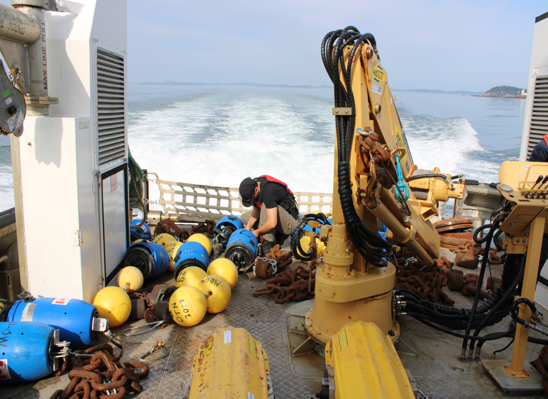
DFO staff deploying acoustic receivers in Musquash estuary to detect tagged fish that migrate through the area. Photo credit: Mike Lawrence (DFO).
DFO continued to monitor ambient conditions in the MPA and partnered with ECW and Anqotum Resource Management to extend its contaminant sampling protocols. The animals and sediments from Musquash MPA were examined for concentrations of polyfluoroalkyl substance (PFAS), a type of contaminant often called “forever chemicals” because they accumulate and last so long once released to the environment. They were successful in collecting tomcod, crabs, mussels and sediments from the site for PFAS analysis.
In 2024, DFO researchers completed the third year of eDNA sampling. While data from 2023 and 2024 are still being processed, preliminary results from 2022 showed considerable promise. This tool will likely continue to be employed as one of the core monitoring methods for years to come.
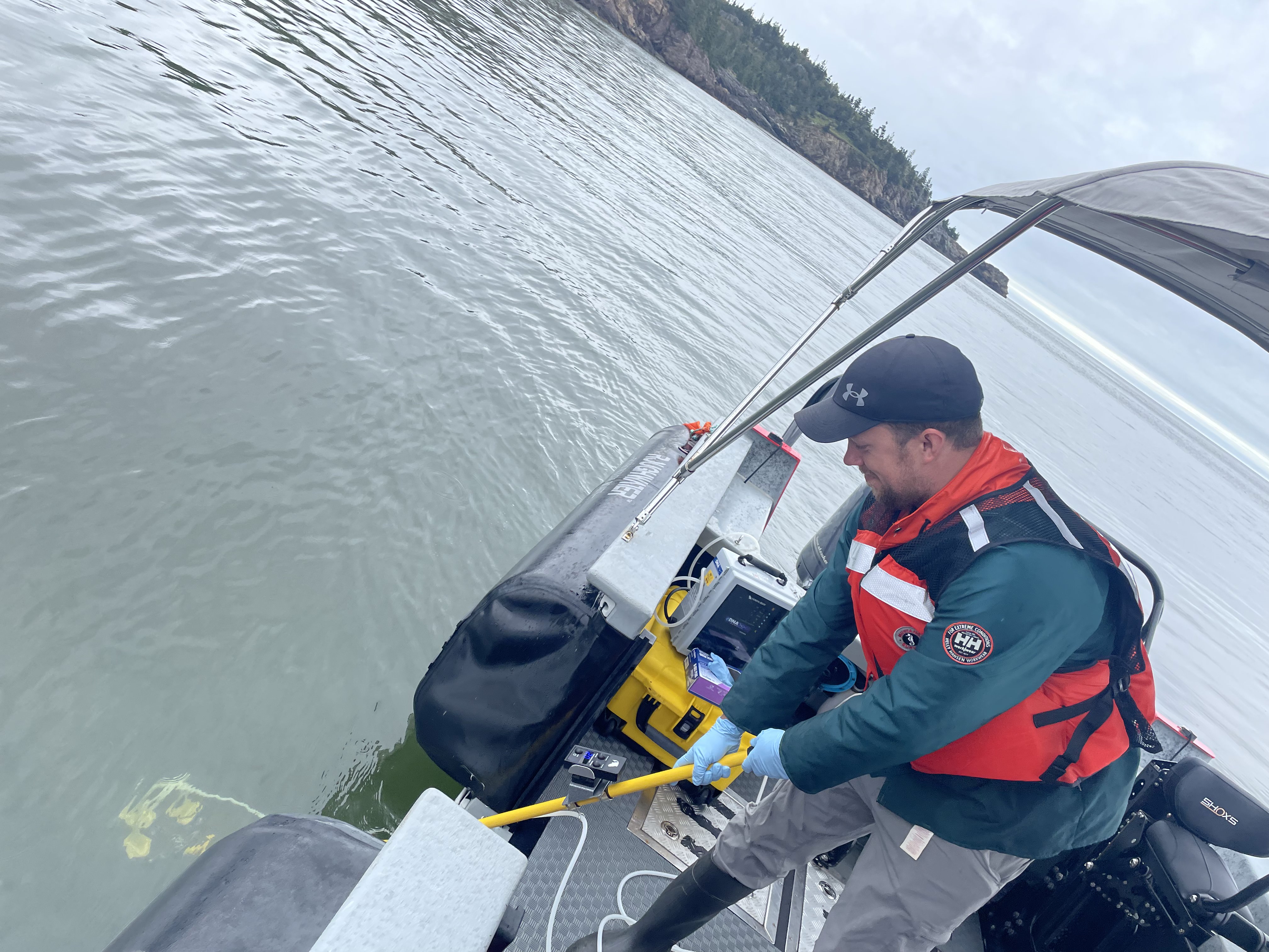
DFO staff collecting water samples to analyze for species presence/absence using eDNA. Photo credit: Ryan Stanley (DFO).
Fish tracking data were recovered from the acoustic receiver array and detections were examined by DFO biologists. Amongst the surprise visitors were several tagged white sharks that made multiple trips into Musquash Harbour, possibly to feed on resident seals.
In January 2024, a research and monitoring workshop was convened at the Saint Andrews Biological Station in NB. Sixty participants reviewed fieldwork and results from investigations in and near the MPA.
University of NB researchers based at the Saint John campus initiated a study of intertidal mudflat communities. Investigators from the Fredericton campus employed a combination of fieldwork and aerial photographs to map and track changes to coastal vegetation.
The ACAP Saint John performed biweekly monitoring of both harbour and grey seals in the MPA. These surveys aim to track seal populations in the area and identify any seasonal trends in seal presence and behaviour.
In 2024, ECW continued another year of baseline monitoring program in the MPA. The organization collects data which are crucial to analyzing trends and detecting changes in the environment, including:
- nearshore biodiversity
- water quality and sediments
Collaboration and partnerships
In 2024, DFO partnered with Anqotum Resource Management and Eastern Charlotte Waterways to share samples collected from Black Beach this summer in support of the PFAS study in the Coastal Environmental Baseline Program. In addition to the PFAS study, Anqotum Resource Management has a project using stable isotope ratios to compare food webs in industrially impacted areas of the Bay of Fundy and Musquash MPA has been sampled as a control site.

Staff from Anqotum and Eastern Charlotte Waterways carry out coastal baseline sampling, assessing population of molluscs and invertebrates along the shore. Photo credit: Kaleb Zelman (DFO).
Dr. Heather Hunt’s lab at UNB Saint John is researching intertidal mudflat and subtidal communities in the Musquash estuary. DFO has also partnered with Dr. Myriam Barbeau at UNB Fredericton as part of her lab’s efforts to study and monitor a number of saltmarsh restoration sites in the upper estuary.
In addition to the 2 above mentioned examples, in 2024, DFO continued its partnerships with:
- NCC
- ACAP Saint John
- DUC
- Ocean Tracking Network
In the spotlight: benefits
Ecological
This MPA protects the largest, ecologically intact estuary in the Bay of Fundy and supports a diverse range of fish and wildlife. This area has high productivity and contains blue carbon ecosystems, which sequester and store carbon in plants and sediments. This MPA is one of the few areas in the Bay of Fundy that has not been heavily modified by humans and it provides connectivity across various habitat types, such as:
- mud and sand flats
- rocky intertidal
- salt marsh
- seagrass beds
- shallow waters
- tidal pools
Socio-cultural
The Musquash Estuary is a well-known sweetgrass harvesting area for Wolastoqiyik who have frequented this area since time immemorial. Sweetgrass (welimahask) is a plant that grows in the upper edges of saltmarshes and is a sacred medicine for many Indigenous Peoples. In addition, the MPA’s proximity to the city of Saint John makes it one of the more popular natural spaces for people to escape the city for recreation, which can foster environmental stewardship.
Economic
As an MPA that’s nestled in between small coastal communities, Musquash provides for and benefits from the blue economy. Lobster and scallop fishing vessels moor at the Small Craft Harbour located in Zone 2a. There is an active commercial lobster fishery in Zones 2 and 3 of the MPA, with traps set in both Spring and Fall fisheries. The scallop fishery takes place during the Winter in Zone 3. Community members rely on the MPA for their livelihoods and in turn they care for the MPA and its surroundings.
Surveillance and enforcement
In 2024, the Musquash MPA had a high rate of compliance with MPA Regulations and there were no MPA related violations recorded.
DFO Conservation and Protection (C&P) officers conduct land, sea and aerial patrols in the Musquash Estuary MPA to carry out surveillance and enforcement efforts. In 2024, over 70 hours of surveillance were conducted in the MPA. C&P is responsible for the majority of patrols, including vehicle and foot patrols and occasional vessel patrols. In 2024, a vessel for patrolling the Musquash Estuary MPA was acquired to increase vessel patrol effort in the area. Offshore Surveillance Fishery Officers conduct aerial surveillance of the estuary as part of special MPA missions, specifically dedicated to MPA surveillance and enforcement.
Activities continued in 2024 as outlined in the enforcement plan and efforts are underway to update the Musquash Estuary MPA enforcement plan for 2025-2026.
Additional surveillance work takes place within the estuary relating to the elver fishery, which saw increased activity in the area during the spring season of 2024. Officers ensure compliance with fishery regulations.
Outreach and engagement
In June 2024, DFO staff attended the Joint Bay of Fundy Ecosystem Partnership/Atlantic Canada Coastal and Estuarine Science Society conference. They presented the history of stewardship and conservation that preceded the MPA in the region and eventually led to a campaign to protect the estuary in perpetuity.
On World Oceans Day (June 8), DFO staff joined an event at the Irving Nature Park in Saint John, NB. The event was hosted by UNESCO’s Stonehammer Geopark and it was an opportunity for the public to learn about the natural environment in their backyard.
DFO continues to work with the NCC to promote education and awareness of the MPA and conservation of the coastal environment. NCC has been making improvements to their trail network in their nature reserve surrounding the MPA. They have also been working with local organizations, like Explore Lorneville, to recruit volunteer trail stewards and provide them with training on MPA regulations as well as best practices in trail building and maintenance. These stewards serve as the eyes and ears of the MPA, as they spend a great deal of time walking the shores and cliffs of the MPA. NCC has also been working with local ATV associations to promote responsible trail use and access.
Related link
- Date modified: