
Planning for land-based erosion and sediment control
This interim standard provides Fisheries and Oceans Canada’s (DFO) national guidance on the implementation of an erosion and sediment control plan for all phases of the project.
On this page
- About this standard
- User guide
- Assessing erosion and sediment mobilization risk
- Selecting control measures
- Drafting an erosion and sediment control (ESC) plan that applies an adaptive management framework
- Glossary
- Appendix: ESC plan checklist
1.0 About this standard
A standard specifies how to implement a specific mitigation measure to achieve its objective and maximize its effectiveness. This standard provides national guidance from Fisheries and Oceans Canada (DFO) on how to implement the following mitigation measure:
- Implement an erosion and sediment control plan for all phases of the project.
It is intended for use in implementing a plan for the management of sediment laden water when conducting works, undertakings and activities (projects) on land, near water. Consult the Standard: In-water site isolation if your project requires the isolation of an in-water site.
By following this standard, project proponents can reduce the risk of harmful impacts to fish and fish habitat to an acceptable level.
When water contacts erodible soils, it creates sediment laden runoff which can discharge into fish habitat and increase the risk of harmful impacts. Projects that typically require erosion and sediment control (ESC) include activities that result in ground disturbance in proximity to watercourses and water bodies (for example, construction of new infrastructure or the maintenance or removal of existing infrastructure). Taking the time to conduct an Erosion and Sediment Mobilization Risk Assessment and prepare an Erosion and Sediment Control Plan during the project planning phase is critical for the successful management of erosion and sediment during all phases of the project.
2.0 User guide
Standards are one of a suite of tools used by the Fish and Fish Habitat Protection Program (FFHPP) to manage the risk of harmful impacts to fish and fish habitat from projects carried out in or near water. They create efficiencies in the regulatory process by standardizing requirements for certain types of common projects.
Standards are not considered stand-alone documents. The conditions under which they can be applied, other applicable management measures (for example, carry out the project in accordance with timing windows), and any engagement or consultation requirements are dictated by the instrument within which the standards are referenced (for example, Fisheries Act Authorization).
Project proponents can indicate their intention to follow one or more DFO standards in their request for review or their application for authorization. Submissions should indicate specific sections of the standards that apply to the proposed project and include any additional site-specific management measures related to the method used.
The nature of the project, the site-specific conditions, the proximity and connectivity of work to fish habitat, and the seasonal timing will inform the risk assessment and dictate the approach and preferred methods of ESC.
If you are uncertain about what methods should be applied based on site-specific conditions, or whether you can meet the standard, consult a qualified environmental professional (QEP) with demonstrated ESC expertise and experience relevant to the project type and project location.
Standards do not remove nor replace the obligation to comply with all applicable statutory and regulatory requirements of the Fisheries Act, the Species at Risk Act, or other federal, provincial, territorial or municipal legislation and policy including guidance regarding species and habitats managed by these jurisdictions.
Up-to-date information on DFO standards can be found on the Projects near water website.
3.0 Assessing erosion and sediment mobilization risk
The level of erosion and sediment mobilization risk, and the methods used to assess the risk, can vary greatly depending on the complexity of the project and site-specific conditions. Therefore, a clear understanding of the scope and phases of the project from initial ground disturbance to completion, the project schedule, and the site-specific environmental conditions is required. Desktop assessments (for example, use of soil loss and water balance models), site visits, or a combination of the 2, may be required to ensure that the risk assessment is thorough and complete. An erosion and sediment mobilization risk assessment should include an assessment of the following 3 erosion and sediment mobilization risk factors:
- exposure of erodible soils to erosive forces
- alteration of site water balance
- potential for discharge of contact water to watercourses or water bodies
3.1 Exposure of erodible soils to erosive forces
In an undisturbed state, the land base is protected from soil erosion by local plant assemblages, their root structures, and the biologically active organic layers of soil. Once vegetation and organic soils are disturbed, the sub-soils become exposed to rain splash erosive forces, surface sheet flow (which can lead to more concentrated flows), winds, and mechanical forces applied by construction equipment, and travel over the exposed area. The risk of harmful impacts to fish and fish habitat arises from the erosion of soil particles, their suspension in surface water, and their transport via runoff to fish habitat.
Soil loss from erosion on site can be estimated using models, such as the Revised Universal Soil Loss Equation For Application in Canada (RUSLEFAC, PDF, 5.7 MB). In this model, site-specific factors including rainfall intensity, soil erodibility, and slope length and steepness are used to calculate estimated soil loss volumes per unit area prior to the application of erosion and sediment control measures. Erosion and sediment control measures (see Sections 4.2 and 4.3) are then considered and used to estimate the percent reduction in soil loss expected. The use of models to predict soil loss are valuable, however the user must also acknowledge their limitations and employ professional judgement. For example, rainfall intensity factors may not reflect current climatic conditions due to climate change.
3.2 Alteration of site water balance
The removal of vegetation and the alteration of soil permeability and soil structure reduces the ability of the affected soils to infiltrate water and the uptake of water from plants. The scale of riparian vegetation removal and soil disturbance will affect the degree to which the local hydrologic conditions are altered and therefore the quantity of increased runoff that will occur. Water balance models may be used to estimate changes in on-site drainage volumes.
3.3 Potential for discharge of contact water to watercourses or water bodies
The site-specific environmental conditions, the proximity of the project to watercourses or water bodies, and seasonal timing will influence the risk of harmful impacts to fish and fish habitat from sedimentation. For example, maintaining an undisturbed vegetated riparian zone, or timing riparian and soil disturbance works to occur when seasonal rainfall is lowest, will help to avoid or reduce the risk. A suite of avoidance and mitigation measures will need to be included in the ESC plan and implemented during each project phase to manage the risk of harmful impacts to fish and fish habitat.
- Obtain a clear understanding of the scope and phases of the project from initial ground disturbance to completion, project schedule, and site-specific environmental conditions.
- Assess site erosion and sediment mobilization risk, taking into account the following 3 risk factors; exposure of erodible soils to erosive forces, alteration of site water balance and potential for discharge of contact water to watercourses or water bodies.
- Assess risk using a combination of desktop assessment methods (for example, models) and site visits.
- Determine the scale of the ESC plan based on erosion and sediment mobilization risk and proximity and connectivity to receiving fish habitat.
- Engage a QEP with demonstrated ESC expertise and experience relevant to the project type and project location to conduct the risk assessment and determine the scope and scale of the ESC Plan.
4.0 Selecting control measures
ESC measures for treating erosion and sediment mobilization risk can include drainage control measures, erosion control measures, and sediment control measures (referred to collectively as drainage and ESC measures). Planning efforts should prioritize site drainage control and the prevention of erosion and suspension of soil particles in surface water when conditions allow. Figure 1 illustrates the relative importance of the 3 distinct types of control measures for varying site conditions. For major earthwork phases it is important to consider staging soil disturbance to control runoff and to continue to divert non-contact water around the site. When it is not practicable to implement and maintain site drainage and erosion controls, it may be necessary to implement sediment control measures including treating sediment-laden runoff prior to it reaching watercourses or water bodies.
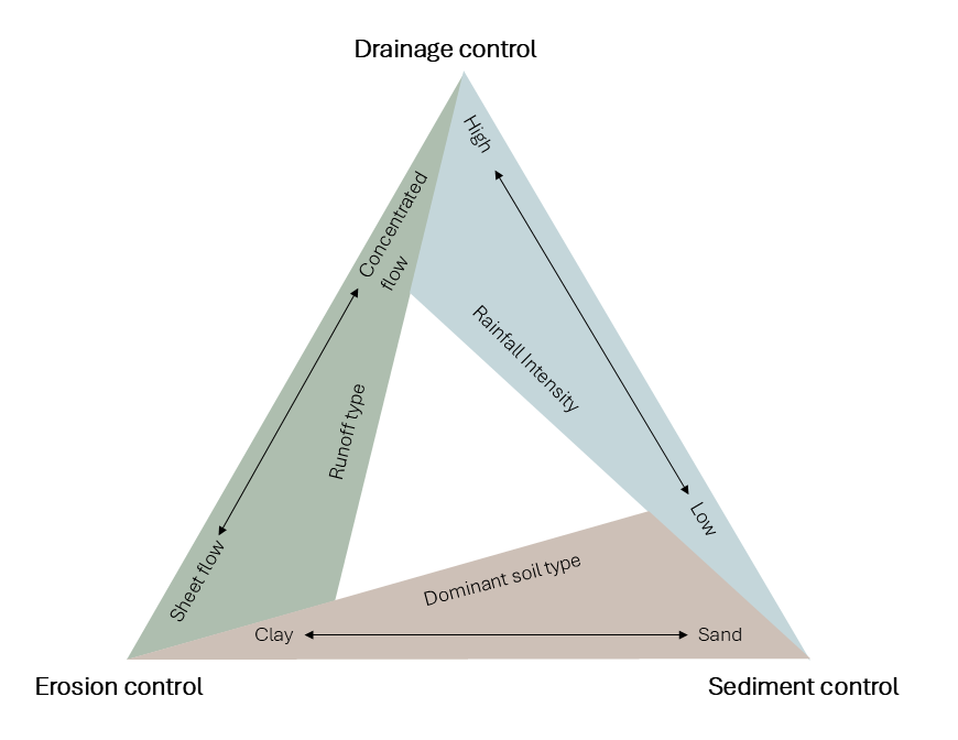
Figure 1 : Relative importance of drainage, erosion, and sediment control measures for varying site condition
Description
Figure 1 demonstrates how precipitation (rainfall) intensity, soil type, and runoff type affect the prioritization and relative benefits of drainage and ESC measures. Note the figure is intended to depict a continuum within the bounds of the triangle and not to imply that one type of control should be used in isolation of others. In fact, it is best practice to understand and consider where the project is on the continuum, and plan for and implement the most appropriate combination of all 3 measure types.
Mitigation measures for ESC are categorized by 3 main types: drainage control measures, erosion control measures, and sediment control measures. Examples are provided for each measure type for reference and are not intended to capture all possible options that could be specified in an ESC plan. Innovative and site-appropriate designs and controls are encouraged, as is the use of locally available and bio-degradable solutions.
4.1 Drainage control measures
Drainage control measures are measures designed for the temporary management of stormwater to prevent or reduce erosion. They are intended to manage the movement of concentrated surface water flows around or through the worksite. Site hydrology and hydraulic engineering principles must be considered to size the drainage control measures and to design effective armouring against the sheer stress of the anticipated flow velocities. It is best practice to design flow conveyances that segregate clean water from sediment laden contact water. This limits sediment control treatment to the treatment of sediment laden runoff resulting from the project. Example drainage control measures include:
- temporary drainage and flow diversion channels
- check dams
- level spreaders
- slope drains
- channel outlet protection
- access road cross ditching
- slope breaks
- flow diversion berms
- stormwater conveyances (piping, culverts, aqueducts, vegetated infiltration swales, etc.)
4.2 Erosion control measures
Erosion control measures are intended to protect exposed soils from raindrop impact and surface sheet flow and to a lesser degree protect against wind erosion and the generation of dust. These measures are planned and applied to keep soils in place and prevent or reduce the creation of sediment laden runoff. Examples of erosion control measures include:
- revegetation (planting, live staking, and seeding) and sodding
- erosion control blankets (ECBs)
- bonded fibre matrix (BFMs)
- turf re-enforcement mats (TRMs)
- mulching and hydraulically applied mulches
- compost and soil treatments (biotic and chemical fertilization)
- gravel or rock armouring
- chemical soil binders and surface stabilizers (for both dust control and soil surface protection)
- slope and surface roughening treatments
- tarpaulin and removable surface covers
- wind break fencing or surface contouring
- geotextiles and soil confinement grid
- nature-based engineering solutions (root supported rip-rap, permeable travel surfaces, stormwater infiltration swales, etc.)
- travel surface armouring (gravel, asphalt, matting, concrete, etc.)
- engineered slope treatments (gabions, interlocking concrete blocks, soil anchoring and shotcrete, mechanically stabilized earth (MSE) wall, etc.)
4.3 Sediment control measures
Sediment control measures are intended to remove soil particles from suspension in site runoff and contain sediment onsite to reduce the risk of harmful impacts to fish and fish habitat from sedimentation. Examples of sediment control measures include:
- vegetated buffer zones
- perimeter controls (soil, mulch, or filter berms, selectively permeable fencing, barrier fencing, low-no gradient perimeter ditching, etc.)
- engineered sediment basins and infiltration areas
- stormwater conveyance inlet protection
- sand and gravel filters
- check dam sediment traps
- pump outlet sediment collection filters (sediment filter bags, sand filters, cellular water holding tanks, etc.)
- construction exits (armouring and wheel washes)
- active sediment and water treatments (methods involving a combination of pumping water, flocculants and other chemical treatments, pH adjustments, and filtering and other physical treatments to remove sediment and pollutants and improve water quality prior to site discharge)
- Select the appropriate combination of mitigation measures including (a) drainage control measures, (b) erosion control measures and (c) sediment control measures to manage the risk of harmful impacts to fish and fish habitat from sedimentation during all phases of the project.
- Give priority to site drainage control measures and erosion prevention and reduction measures over sediment control measures (including treatment of sediment laden water) when conditions allow.
- Engage a QEP with demonstrated ESC expertise and experience relevant to the project type and project location to verify the choice of measures.
- Install drainage and ESC measures following the installation specifications and instructions in the ESC plan or those provided by the ESC product manufacturer.
- For additional guidance on installation and maintenance of commonly used ESC measures, refer to the National Standard of Canada CSA W208:20.
5.0 Drafting an ESC plan that applies an adaptive management framework
An effective ESC plan must be based on a clear understanding of the scope and phases of the project from initial ground disturbance to completion and the project schedule and duration. It includes a sound initial risk assessment (Section 3.0) as well as proposed treatment of erosion and sedimentation risk by applying the appropriate control measures (Section 4.0). It should be reviewed and approved by a QEP and should apply an adaptive management framework to address:
- maintenance of installed measures that have functioned according to the ESC plan but have exceeded their designed capacity
- design and installation of contingency measures to replace measures that have not functioned according to the ESC plan
- re-assessment and adaptation of the ESC plan when a variation from anticipated site conditions occurs
The design and implementation of planned drainage and ESC measures needs to reflect how the erosion and sediment mobilization risk changes throughout the project life cycle. Figure 2 illustrates how the level of risk needs to be re-assessed, and the ESC plan adapted when changes in site condition or project plans occur or when measures do not perform as expected.
- Draft an ESC plan that applies an adaptive management framework.
- Engage a QEP to review and approve the final ESC plan.
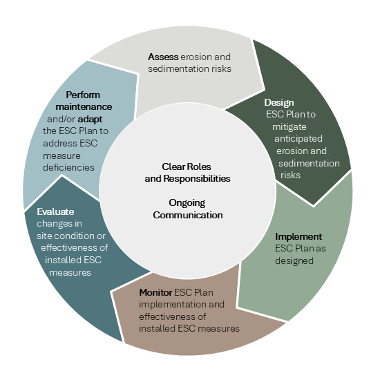
Figure 2: ESC adaptive management framework
An ESC plan that applies an adaptive management approach includes the following elements:
- contingency planning
- ESC plan maps
- an ESC monitoring program
- a maintenance, repair and removal program
- an approach to assigning and communicating roles and responsibilities to all responsible parties
5.1 Contingency planning
Contingency planning includes preparing for potential future events that could increase the risk of harmful impacts to fish and fish habitat. The ESC plan should outline contingency measures to address these events. For example, plan revisions that include more robust measures may be required if there are project delays that extend beyond the typically dry summer period into the fall when more precipitation is anticipated. Other examples of events include weather forecast changes, or, monitoring results indicate measures have exceeded their functional longevity, require maintenance before expected, or are ineffective.
- Draft an ESC plan that includes contingency planning for each phase of project implementation.
- Identify changes in the schedule, environmental conditions or other events that may impact the ESC plan and explain the contingency measures to be implemented.
5.2 ESC plan maps
ESC plan maps are a key tool used by construction crews to understand the timing, location and type of drainage and ESC measures that are required for each phase of work. It should be recognized that ESC plan maps for a particular phase of work typically reflect the measures that are expected to be installed before the completion of that phase. However, all measures may not be fully implemented during a particular phase. Also, plans may change based on site conditions encountered. To account for this, it is important to document progress through plan annotations or revisions approved by a QEP.
- Draft an ESC plan that includes ESC plan maps for each phase of project implementation.
- Include the location of all drainage and ESC measures to be installed.
- Provide installation specifications or plan typical drawings for each drainage and ESC measure specified in the ESC plan.
- Indicate locations of the nearest receiving watercourses or water bodies and their connectivity to fish habitat.
- Make plan notes regarding daily/end of shift site stabilization and/or commitment to ongoing active site management.
- Describe the process to be used for plan revisions (internal reporting and tracking) and sign-off by a QEP and other required personnel.
5.3 ESC monitoring program
An effective ESC monitoring program documents the implementation and effectiveness of the ESC Plan specifications, flags maintenance needs, and recommends actions to address ESC plan deficiencies and protect fish and fish habitat. The monitoring frequency and timing of inspections should be commensurate to the scale and scope of the project and associated risk of harmful impacts to fish and fish habitat.
- Draft an ESC plan that includes a monitoring program commensurate to the scale and scope of the project.
- Identify when monitoring will occur and the monitoring frequency. Describe factors that influence the monitoring schedule and frequency such as the project phase, the season, and weather events.
- Indicate the ESC monitoring report frequency and structure.
- Identify the responsible party for monitoring water quality for the purpose of documenting conformity with project specific criteria or Canadian Council of Ministers of the Environment (CCME) criteria (PDF, 357 KB) (if applicable).
- Describe the expected communication structure for both field level communications and office-based reporting.
- Describe the internal ESC monitoring documentation process. Note: internal ESC monitoring documentation must be made available to DFO in the event of a sediment or sediment laden water release to fish habitat.
- For additional guidance with respect to monitoring for projects greater than 1ha (10,000 sq. m) or when required by DFO, refer to CAN/CSA-W202-18 Erosion and Sediment control Inspection and Monitoring.
5.4 ESC maintenance, repair and removal program
An effective ESC maintenance program is proactive and involves participation and support from the entire project team. Timely repair and maintenance of drainage and ESC measures prevents gaps in their effectiveness and provides ongoing protection for fish and fish habitat. Also, the removal of all temporary and non-biodegradable ESC measures is the responsibility of the project proponent and must be considered as a component of the project.
- Draft an ESC Plan that includes a proactive maintenance, repair and removal program.
- Identify the schedule that construction crews will follow to inspect drainage and ESC measures within their work area.
- Describe how any maintenance requirements will be communicated according to roles and responsibilities.
- Outline the necessary construction equipment, supplies, and labour that will be available to support drainage and ESC measure installation and ongoing maintenance and repair requirements.
- Identify and include on the plan map all temporary, non-biodegradable ESC measures that require removal once the site is restored and stabilized.
5.5 Roles and responsibilities
A QEP with demonstrated ESC expertise and experience relevant to the project type and project location will conduct the risk assessment, verify the choice of measures, and review and approve the final ESC plan. However, many other personnel may be involved. The roles and responsibilities of all personnel involved in the ESC planning and implementation process must be clearly outlined to facilitate clear communications and information transfer between parties. Of particular importance is the identification of how the communication feedback loop between the QEP, construction crew leads, ESC monitors, and ESC maintenance crews will function to support effective drainage and ESC measure implementation. Note that the number and type of roles will vary from project to project according to the scope and scale of the project.
- Draft an ESC plan that clearly outlines roles and responsibilities of all parties involved in ESC activities.
- Identify the responsible parties for ESC plan development, site orientation and training, ESC implementation, monitoring and maintenance, plan updates and revisions.
- Outline the training and experience requirements for each responsible party.
- Describe how communication between responsible parties will be structured and facilitated to support ongoing maintenance, repair, and potential changes to the ESC plan identified through ESC monitoring and as construction progresses.
- Document the person or role responsible for the duty to notify under subsections 38(4) and 38(7) of the Fisheries Act (refer to the Glossary for additional details about the duty to notify).
6.0 Glossary
- Contact water
- Water coming from within the worksite boundaries, in the form of surface flows, rainfall, stormwater, melting snow/ice, and/or other sources.
- Contingency measures
- Secondary actions implemented if the primary measures such as avoidance, mitigation, or offsetting measures fail to meet their expected outcomes.
- Duty to notify
- Under Section 38 of the Fisheries Act, there is a duty to notify an inspector, a fishery officer, a fishery guardian or other person prescribed by regulations when the death of fish or the harmful alteration, disruption or destruction of fish habitat occurs that is not authorized under the Act, or when there is a serious and imminent danger of such an occurrence. Section 38 imposes duties upon persons responsible for such works, undertakings or activities to take corrective measures and to provide written reports when there are such occurrences. Failure to notify, take corrective measures or report in such situations may result in penalties. Section 38 also applies to the deposit of deleterious substances under the pollution prevention provisions of the Fisheries Act.
- Ordinary high water mark
- The usual or average level to which a body of water rises at its highest point and remains for sufficient time to change the characteristics of the land. In flowing waters (for example, rivers and streams) this refers to the ‘active channel/bank-full level’ which is often the 1:2 year flood flow return level. In inland lakes, wetlands or marine environments, it refers to those parts of the water body, bed and banks that are frequently flooded by water, leaving a mark on the land. It’s where the natural vegetation changes from predominately aquatic vegetation to terrestrial vegetation (excepting water tolerant species). For reservoirs this refers to normal high operating levels (meaning, full supply level).
- Practicable
- The term intended to reflect a combination of feasibility of installation, costs, and suitability to the construction sequencing.
- Qualified environmental professional (QEP)
- A person experienced in identifying and analyzing risks to fish and fish habitat generated from various works, undertakings or activities conducted in or near water, and implementing management measures to avoid and mitigate those risks. They possess a post-secondary degree or diploma in biological, geophysical or environmental sciences and are referred to as:
- applied scientists
- aquatic biologists
- environmental consultants
- fisheries biologists
- fisheries technicians
- fluvial geomorphologists
- natural resource consultants
- Revisions
- Refers to changes made to ESC plans and/or annotations on printed plans.
- Riparian zone
- Area located between a watercourse or water body’s ordinary high water mark and upland area. The width of the riparian zone may be further defined by provincial, territorial or municipal regulations or guidelines.
- Runoff
- The flow of water over the soil surface, or contained within constructed water conveyance structures (for example, stormwater services or ditches), resulting from excess rainwater, melt water, stormwater, and/or other sources that cannot be absorbed into the ground onsite and results in offsite surface water discharge.
- Sediment laden water or sediment laden runoff
- Term used to describe water with high level of turbidity and/or high concentration of total suspended solids.
- Sheet flow
- Flow over plane surfaces (for example, parking lots, farm fields, and lawns). Sheet flow usually occurs in the headwaters of a stream near the ridgeline that defines the watershed boundary. Typically, sheet flow will eventually transition to shallow concentrated flow.
- Shear stress
- A force that causes soil to deform.
- Turbidity
- A measure of how much light is scattered or absorbed by particles suspended in water. It is caused by particles that are usually too small to see with the naked eye, such as clay, silt, fine sand, plankton, algae, bacteria, etc.
- Total suspended solids
- A measure of the dry weight of particles in water that are too large to pass through a filter. These particles can include sand, silt, clays, plankton, algae, bacteria, etc. Total suspended solids are measured in milligrams per litre.
Appendix: ESC plan checklist
- Date modified: