
Regional Oceans Plan - Scotian Shelf, Atlantic Coast, Bay of Fundy
Background and Program Description
Table of Contents
Foreword
The Regional Oceans Plan outlines the approach and actions that Fisheries and Oceans Canada (DFO) is taking to support oceans and coastal management in the Maritimes Region. The Plan responds to DFO’s responsibilities under the Oceans Act to lead and facilitate integrated and ecosystem approaches to the management of Canada’s oceans. The Plan represents an evolution of previous oceans and coastal management efforts within the Maritimes Region, including the Eastern Scotian Shelf Integrated Management (ESSIM) Initiative that concluded in 2012. The current approach moves beyond the Large Ocean Management Area (LOMA) concept applied in the earlier phases of DFO’s Integrated Oceans Management Program to one that is based on nationally defined marine bioregions. The Scotian Shelf-Bay of Fundy bioregion corresponds to DFO’s Maritimes Region and provides the geographic basis for the Plan.
The Plan responds to a set of over-arching goals for achieving integrated and ecosystem approaches to oceans and coastal management:
- Effective decision making
- Ecosystem approach to management
- Spatial planning and management
- Marine conservation
- Collaboration and engagement
- Departmental alignment
The Plan is composed of two related documents, a Background and Program Description (this document), and an Implementation Priorities document. The Background and Program Description is organized in five parts. The Introduction section describes the purpose, vision, goals and guiding principles for the Plan and the activities under it. A Regional Overview and Context section identifies the ecological, socio-economic and jurisdictional contexts for oceans and coastal management. The Oceans and Coastal Management and Marine Protected Area Planning and Management sections set out the department’s core Oceans Act programs, capacities and activities in the Maritimes Region. The Collaboration and Engagement section identifies the mechanisms both within the department and with external government partners to coordinate oceans-related policies, programs and management decision making. Approaches for engaging, consulting and working with marine stakeholders are also described in this part of the Plan.
The Integrated Oceans Management Program Documents Annex provides a list of DFO’s key reports and studies related to oceans and coastal management in the Maritimes Region.
The second part of the Plan, Implementation Priorities (seperate document), identifies the key actions that DFO is taking to meet the goals of the Plan. These implementation priorities have been established for defined periods of time (initially for 2014-2017) and will be updated to meet changing needs and funding availability. These actions are organized in terms of four main priority areas for DFO’s regional Integrated Oceans Management Program: (1) MPA Network Development; (2) MPA Establishment, Management and Monitoring; (3) Environmental Preparedness and Response Planning; and (4) Implementing Oceans and Coastal Management Measures Using a Risk-based Approach.
The Plan will be reviewed every three years to account for changing conditions and priorities. It will also include regular monitoring and reporting processes to assess the effectiveness and relevance of the efforts and to communicate internally within DFO and externally with other government departments and stakeholders.
Introduction
Purpose
The Regional Oceans Plan outlines the approach and actions that Fisheries and Oceans Canada (DFO) is taking to support oceans and coastal management in the Maritimes Region. The Plan responds to DFO’s responsibilities under the Oceans Act to lead and facilitate integrated and ecosystem approaches to the management of Canada’s oceans. Departmental actions to advance regional priorities are profiled throughout the document and also presented in summary form in the Implementation Priorities document in relation to the over-arching goals of the Plan.
The Plan represents an evolution of previous oceans and coastal management efforts within the Maritimes Region, including the Eastern Scotian Shelf Integrated Management (ESSIM) Initiative that concluded in 2012. It draws on lessons learned from the ESSIM process, as well as other initiatives. The Plan moves beyond the Large Ocean Management Area (LOMA) concept pursued initially through DFO’s Integrated Oceans Management Program and uses the Scotian Shelf-Bay of Fundy bioregion as its geographic basis. The bioregion, which corresponds with the department’s administrative boundaries for the Maritimes Region, encompasses the offshore Scotian Shelf and Gulf of Maine, the Atlantic coast of Nova Scotia, and the Bay of Fundy.
Within the Maritimes Region, the lead for the department’s Integrated Oceans Management Program is the Oceans and Coastal Management Division, housed within the Ecosystem Management Branch. The Oceans and Coastal Management Division is organized to develop and implement three core, inter-related Program components: (1) Oceans and Coastal Management; (2) Marine Protected Area Planning and Management; and (3) Collaboration and Engagement. The central part of the Plan is organized in terms of these three components and lays out the main capacities, activities and outputs delivered through them.
The Plan supports a new approach for the Integrated Oceans Management Program that is focussed on priority management needs and activities that are identified through ecosystem and risk management approaches, and addressed through effective management instruments and tools. Within this approach, DFO commitments and actions for oceans and coastal management are clearly aligned and linked with the department’s mandate, authorities and responsibilities. Activities under the Plan also correspond directly to a nationally-defined set of outcomes and outputs for the Integrated Oceans Management Program.
The Plan places a strong emphasis on collaboration and engagement, reflecting the broad range of interests and complexities in managing activities in the marine environment. Ongoing communication, coordination and alignment within DFO is essential to ensuring effective management and coherent decision making. Intergovernmental mechanisms, including Memoranda of Understanding (MOUs) and existing governance bodies, will continue to be used to establish priorities and actions that are aligned with various mandates for oceans and coastal management held by other federal and provincial departments. The Plan also identifies a range of engagement mechanisms for working with marine stakeholders and industry to advance oceans and coastal management in the Maritimes Region.
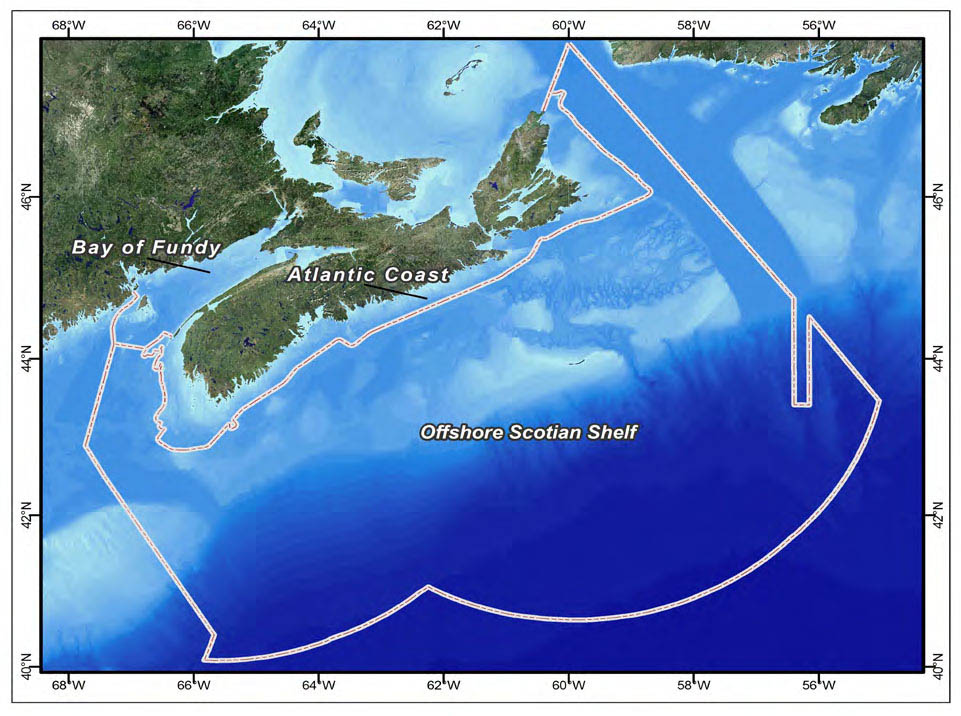
Figure 1: Planning Areas in Scotian Shelf-Bay of Fundy Bioregion, DFO Maritimes Region
Figure 1 is a map of the area covered by the Regional Oceans Plan showing the extent of the Exclusive Economic Zone and boundaries with the Newfoundland and Gulf Regions of DFO and with the US. It indicates the Bay of Fundy, Atlantic Coast and Offshore Scotian Shelf areas within this overall area.
Vision
Healthy marine and coastal ecosystems, sustainable communities and responsible use supported by effective management processes.
Goals
The Plan is focussed on the following over-arching goals:
Effective Decision Making
Timely access to accurate and validated information for decision making is a critical component of oceans and coastal management. Under the Plan, DFO is focussed on developing knowledge products and tools, providing validated and accurate information, and preparing area and issue-specific operational guidance for managers and decision makers both within and outside the department. Ensuring this information is readily available in a timely manner is equally important. These products will support the highest priority issues within the Maritimes Region as determined by expert knowledge, stakeholder input, and risk-based analysis. The development and accessibility of this type of information will support better decision making by all parties, including government, industry and the broader community.
Ecosystem Approach to Management
DFO is pursuing an ecosystem approach to management for all aspects of its mandate. This reflects current scientific thought and international guidance and commitments. An ecosystem approach places the ecosystem at the forefront of consideration when managing those activities that affect it. By understanding thresholds and limits beyond which the system would be impacted, the activities are managed to maintain the ecosystem within its natural tolerances. All management measures advanced under the Plan will take an ecosystem approach.
Spatial Planning and Management
DFO supports a spatial approach to oceans and coastal planning and management. This involves the use of validated spatial data, maps and analytical methods for addressing human use and ecosystem interactions. A pragmatic and operational approach to the principles of marine and coastal spatial planning can provide effective, flexible and adaptive solutions for oceans and coastal management problems.
Marine Conservation
DFO is committed to effective marine conservation through the development of a network of Marine Protected Areas (MPAs) and the ongoing management of existing MPAs and conservation areas under the Plan. The department is also placing a priority on risk assessments and management guidance for the suite of Ecologically and Biologically Significant Areas (EBSAs) identified throughout the bioregion.
In recognition of the need to balance comprehensive ecosystem protection with responsible development and use, DFO supports the careful selection of appropriate conservation instruments, measures and tools to address regional needs and threats.
Collaboration and Engagement
DFO supports a collaborative approach when addressing oceans and coastal issues in order to share resources and knowledge, seek advice and work together to advance common priorities. This is critical given the multiple jurisdictions present within the coastal and marine environments. A range of intergovernmental and stakeholder engagement, consultation and participatory methods are supported under the Plan.
Departmental Alignment
The Plan supports a coordinated and consistent approach to oceans and coastal management within DFO. A “whole of DFO” approach is important to ensure effective and coherent decision making. One of the aims of the Plan is to strengthen departmental management and decision making by responding with one voice on cross-cutting issues, such as offshore oil and gas, renewable energy development, marine transportation, or environmental incident preparedness and response. In addition, regular coordination and information sharing is required to ensure that departmental policies are well aligned and cohesive.
Key examples of responsibilities requiring a cross-cutting departmental response include fisheries management and protection, aquaculture development, aquatic species at risk, marine conservation planning, and ecosystem science and research.
Legislative and Policy Context
The primary legislative basis for the Plan is provided by the Oceans Act that sets out in law the principles of oceans and coastal management that apply to all federal authorities with some role regarding Canada’s oceans, its resources and uses. The Act outlines specific oceans and coastal management commitments to be led by the federal Minister of Fisheries and Oceans, including the following:
- Lead and facilitate the development and implementation of a national strategy for the management of estuarine, coastal and marine ecosystems (Sections 29 and 30);
- Lead and facilitate the development and implemen- tation of plans for the integrated management of all activities or measures in or affecting estuaries, coastal waters and marine waters (Section 31);
- Develop and implement policies and programs with respect to matters assigned by law to the Minister for the purpose of implementing integrated management plans (Section 32);
- Coordinate with other Ministers, boards and agencies for the implementation of policies and programs of the Government of Canada with respect to all activities or measures in or affecting coastal and marine waters (Section 32);
- Designate Marine Protected Areas (Section 35-1) and lead and coordinate the development and implementation of a national system of Marine Protected Areas for the purposes of implementing integrated management plans (Section 35-2); and
- Establish marine environmental quality guidelines, objectives and criteria respecting estuaries, coastal waters and marine waters (Section 52.1).
To support these commitments under the Oceans Act, DFO is mandated to “gather, compile, analyse, coordinate and disseminate information” and to “cooperate” or “enter into agreements” with other “Ministers, boards and agencies of the Government of Canada, provincial and territorial governments, affected Aboriginal organizations, coastal communities and other persons and bodies” (Section 33-1).
DFO’s role under the Oceans Act as the lead federal authority for oceans is supported by Canada’s Oceans Strategy (2002) and the department’s Policy and Operational Framework for the Integrated Management of Estuarine, Coastal and Marine Environments in Canada (2002). These two documents set out the policy objectives and overall approach to Integrated Oceans Management for DFO in collaboration with its partners at the federal, provincial and territorial levels of government, Aboriginal organizations, and other oceans and coastal interests.
The Integrated Oceans Management Program operates under a national set of outcomes, outputs and associated activities. The three core outcomes of the Program are (1) collaboration among ocean regulators and users, (2) access to sound knowledge, advice and decision support, and (3) awareness and accountability by regulators and users to their respective roles and responsibilities for the management of Canada’s ocean ecosystems and resources. The Program is focussed on achieving these national outcomes by delivering associated outputs of collaborative governance structures, effective management tools, knowledge products and advice, and conservation planning and instruments, including Oceans Act Marine Protected Areas. Ultimately, the Program outcomes link directly to DFO’s strategic outcomes for Sustainable Aquatic Ecosystems, Economically Prosperous Maritime Sectors and Fisheries, and Safe and Secure Waters.
In addition to the provisions of the Oceans Act, DFO uses its responsibilities under several other pieces of legislation to support oceans and coastal management in the Maritimes Region. These include the Fisheries Act, Species at Risk Act, Canadian Environmental Assessment Act, and the Canada Shipping Act, and their related policies, programs and regulations.
The Oceans Act and its supporting policies and programs respond to a number of Canada’s international oceans governance commitments. These include the range of priorities, agreements and measures under the United Nations Convention on the Law of the Sea and the Convention on Biological Diversity, among other instruments. The Plan provides a regional vehicle for supporting relevant DFO initiatives to address Canada’s international oceans-related commitments.
The Eastern Scotian Shelf Integrated Management Initiative: Pilot Project in Ocean Management
The Eastern Scotian Shelf Integrated Management (ESSIM) Initiative was the first offshore integrated management effort under Canada’s Oceans Act. From 1998 to 2006, the main focus of the ESSIM Initiative was the development of an Integrated Ocean Management Plan to provide long-term direction and commitment for integrated, ecosystem-based and adaptive management of all marine activities on or affecting the eastern Scotian Shelf. The resulting Plan was organized by three over-arching goals -- Collaborative Governance and Integrated Management, Sustainable Human Use, and Healthy Ecosystems -- and a series of management strategies aimed at implementing these goals. From 2006-2011, the ESSIM Initiative focussed on implementing the objectives and management strategies. The ESSIM process also fostered the establishment of a Stakeholder Advisory Council and the inter-governmental Regional Committee on Coastal and Ocean Management. As a result of a departmental shift to bioregional planning and implementation, the ESSIM Initiative ended in 2012.
Work in this Large Ocean Management Area (LOMA) was initially undertaken as a pilot project to develop capacity and experience with integrated management. A formal review and evaluation of the ESSIM Initiative and associated Plan was undertaken in 2012-13. This review helped shape the current Regional Oceans Plan so that it builds on the strengths and lessons of the ESSIM experience and addresses the challenges it faced.
Guiding Principles
DFO implements its responsibilities for the Integrated Oceans Management Program using the following principles and approaches as articulated in the Oceans Act:
- Sustainable development is economic development of resources that meets the needs of the present generation, but does not compromise the ability of future generations to meet their own resource needs.
- A precautionary approach to management errs on the side of caution in decision making.
- Adaptive management recognizes that management is continually changing, and management practices must be flexible so as to respond to these changes.
- An ecosystem approach to management places the ecosystem in the forefront and human activities are managed so the state of the ecosystem remains within an acceptable range.
- A collaborative approach is used to engage and involve other government departments, Aboriginal organizations, marine sectors, and the broader public on oceans and coastal management activities under the Oceans Act.
- Integrated management is the planning and management of human activities in a comprehensive manner while considering all factors necessary for the conservation and sustainable use of marine resources and the shared use of ocean space.
Approach
The aim of the Plan is to focus on priority issues related to DFO’s mandate where an integrated management approach can be pursued. This approach is driven by the identification of key issues or pressures, the assessment and management of the risks they pose, and use of targeted collaboration and engagement with responsible and affected parties, rather than sustaining complex and lengthy planning processes. All DFO commitments and actions under the Plan are clearly aligned with the department’s mandate, authorities and responsibilities.
This approach builds upon many of the positive aspects of the ESSIM process and the lessons learned and experiences of the Integrated Oceans Management Program since the passing of the Oceans Act. Efforts to share information and collaborate with other organizations and initiatives that support the priorities under the Plan will continue. Established stakeholder relationships will be supported to ensure progress on high priority issues. Public communication and engagement is also used to ensure awareness of issues and the efforts that DFO is taking to address them, and provide opportunities for input.
Intergovernmental engagement and coordination continues to be pursued to support the efforts of other organizations’ actions.
The expanded focus of the Plan to include inshore and coastal areas involves many levels and departments of government. DFO works with the range of departments that have direct mandates for coastal areas. The Regional Committee on Coastal and Ocean Management will continue to be a formal mechanism for intergovernmental coordination on both coastal and offshore issues. Coordination is supported under an existing Memorandum of Understanding (MOU) on Coastal and Ocean Management with the Province of Nova Scotia. A similar arrangement is under discussion with the Province of New Brunswick. DFO will continue to partner on existing coastal management initiatives within the Maritimes Region, including that of the Bras d’Or Lakes Collaborative Environmental Planning Initiative (CEPI) and the Southwest New Brunswick Marine Advisory Committee (SWNB MAC).
What is the relationship between Oceans and Coastal Management and MPA Planning and Management?
The Regional Oceans Plan outlines DFO’s priorities for its Integrated Oceans Management Program in the Maritimes Region. Many of these priorities fall within the inter-related Program components of Oceans and Coastal Management and Marine Protected Area (MPA) Planning and Management. Under the Oceans and Coastal Management component, priorities include developing tools and knowledge products to better inform planning and management decisions, collaborating with government departments and stakeholders, and coordinating internal DFO policies, programs and decision making processes.
For the MPA component, priorities are to complete the designation of the proposed St. Anns Bank MPA, manage existing MPAs and other conservation areas, and lead the development of an MPA network plan for the bioregion. Many of the activities under the Oceans and Coastal Management component will complement and support MPA planning. For example, the work to compile, characterize and map human uses allows for the careful consideration of potential socio-economic and use impacts and costs involved in both bioregional and site-specific MPA planning. Synergies and efficiencies also occur in terms of collaboration and engagement activities as common mechanisms and methods are used to work with government partners and stakeholders.
Regional Oceans Plan
Vision
Healthy marine and coastal ecosystems, sustainable communities and responsible use supported by effective management processes
Goals
- Effective Decision Making
- Ecosystem Approach to Management
- Spatial Planning and Management
- Marine Conservation
- Collaboration and Engagement
- Departmental Alignment
Activities
- Risk Assessment and Issue Prioritization
- Spatial Information and Analysis
- Operational Guidance and Knowledge Products
- Bioregional Assessment and Reporting
- Departmental, Intergovernmental and Stakeholder Engagement
- MPA Network Development
- MPA and Conservation Area Management
Program Components
- Oceans and Coastal Management
- Marine Protected Area Planning and Management
- Collaboration and Engagement
Figure 2: Regional Oceans Plan: Vision, Goals, Program Components and Activities
Monitoring and Reporting
The Plan will include regular monitoring and reporting processes to assess the effectiveness and relevance of the efforts under it, and to communicate results internally within DFO and externally with other government departments and stakeholders. A full review of the Plan will occur every three years to account for changing conditions and priorities. Interim reports and updates on the Plan will also be prepared and made available to all interested parties.
DFO’s activities under the Plan will also be monitored and reported through internal departmental performance measurement systems. These will take place at both a regional and national level. This work will be to ensure actions under the Plan are relevant to the needs in the area, meet expected outcomes, and are consistent with national approaches under the Integrated Oceans Management Program. Specific actions led by DFO under the Plan will be reported and updated on an annual basis through the department’s work planning and performance management processes.
DFO will draw upon information and expertise from within the department, including its Oceans and Ecosystems Science and Policy and Economics sectors, and from other oceans-related organizations with relevant knowledge and information, to support monitoring and reporting under the Plan. In addition, the Plan will draw upon information about the overall health of the bioregion available in the recently completed State of the Scotian Shelf and State of the Gulf of Maine reports. These reports address a number of issues covered by the Plan and describe the current conditions, driving forces, impacts and actions underway to address them. Other available reports and studies on oceans-related trends and status may also be considered in relation to reporting under the Plan.
The Evolution of the Maritimes Regional Integrated Oceans Management Program: Developing Capacity for Oceans and Coastal Management
From the beginning, the Integrated Oceans Management Program in the Maritimes Region has taken a “learn by doing” approach in meeting the ambitious oceans management commitments outlined in the Oceans Act. As a new national program, there was little previous experience to draw from and many lessons have been learned from the early work on the Region’s Large Ocean Management Area on the eastern Scotian Shelf, coastal management areas in the Bras d’Or Lakes and Southwest New Brunswick, and through the selection, designation and on-going management of the Gully and Musquash MPAs and Coral Conservation Areas. Considerable capacity has been developed over the years in a number of key areas that continue to support the Oceans Act mandate and help in the implementation of the Regional Oceans Plan.
The Oceans and Coastal Management Division (OCMD), which is the lead for the Integrated Oceans Management Program and this Plan, has developed strong multidisciplinary capacity in the areas of oceans and coastal management, conservation planning, engagement and collaboration, decision support and advice for problem solving, and the analysis and use of spatial data and information. The development of knowledge, skills and experience in policy, planning and management has been instrumental to the Program given the multidisciplinary nature of the work.
This has been supported by the need to serve as an “honest broker” and facilitate work among the diverse interests involved in the marine and coastal environments, including other levels and departments of government, industry, academics, First Nations, conservation organizations and coastal communities. This experience and the structures and relationships created to support this engagement remain invaluable. Practical “on the water” actions, including MPA site management, operational advice and decision support for marine development projects, marine research on sensitive areas, critical habitat identification for aquatic species at risk, and influencing environmental site assessment outcomes, are examples that have helped focus the Program on real world problem solving. This work is grounded in a commitment and ongoing investment in spatial decision support, including geographic data analysis and mapping, a human use atlas, the use of advanced surveillance and monitoring technologies, and the completion of ecological, socio-economic, and traditional knowledge studies.
In these ways, DFO has made considerable strides in implementing the Oceans Act and has built capacity in a wide range of disciplines required to continue meeting its commitments.
Regional Overview
This section describes the ecological, social, economic and jurisdictional contexts for oceans and coastal management and marine conservation planning in the Maritimes Region. Key management issues and trends are also highlighted, including interactions between human activities and the marine environment, and conflicts between human activities. Governance mechanisms that have been developed to help address the conflicts, manage impacts, and respond to related issues are referenced. Information presented here on the natural environment, human activities, and the key issues related to them has been drawn from a number of overview documents listed in the Integrated Oceans Management Program Documents section (Annex 1).
Ecological Context
This Scotian Shelf-Bay of Fundy bioregion to which this Plan applies is approximately 476,000 km². It is a productive and diverse ecosystem, providing food and shelter for a variety of species ranging from microscopic plankton to the largest whales. Physical habitats are similarly diverse, with a variety of coastal habitats, offshore banks and basins, steep slopes and underwater canyons, and the largely unknown abyssal plain. For the purposes of this Plan, the Scotian Shelf-Bay of Fundy bioregion has been divided into three planning areas – the Offshore Scotian Shelf, the Atlantic Coast and the Bay of Fundy – which are briefly described below.
The Atlantic Coast
The Atlantic Coast planning area includes the area from the high water mark to the 12-nautical mile limit of the Territorial Sea, extending from Cape North, Cape Breton, into the Bay of Fundy (Figure 1). The Atlantic Coast has a variety of shoreline habitats, such as rocky shores and headlands, large bays and inlets, estuaries, salt marshes, and sandy and rocky beaches. Information on the Atlantic Coast planning area is patchy, with some areas studied extensively and others not at all. Several recent DFO studies have focused on identifying areas of ecological significance. Threats to coastal ecosystems are often linked to land based sources of pollution, including effluent from wastewater treatment and runoff from coastal development, forestry and agriculture.
Another threat is the loss of habitat from residential, industrial and commercial development. It is estimated that 70% of the population in Nova Scotia lives within a coastal community.
Eelgrass Decline
Eelgrass is an important component of the coastal ecosystem found along the Atlantic Coast in sheltered bays and coastal waters. The most commonly occurring species in the inshore region is Zostera marinus. Eelgrass beds rank among the most highly productive ecosystems in the world. Eelgrass beds provide important nursery habitat for fish and invertebrates by providing protection from predators, substrate for attachment of invertebrates and other algae, and an abundant supply of food. Eelgrass is also an important food source for birds and other species. Ducks and geese feed extensively on intertidal eelgrass beds during the winter. Eelgrass decay provides a food source for species such as shrimps, amphipods, crabs, filter feeding bivalves and polychaetes. Eelgrass beds on the Atlantic Coast have been declining in recent decades due to coastal development, eutrophication and invasive green crabs. Although there is limited information for the entire coast, some locations reported declines of 30% to 90%.
The Offshore Scotian Shelf
Moving seaward from the coast, the Offshore Scotian Shelf planning area is defined as the waters from the 12-nautical mile limit of the Territorial Sea to the 200-mile limit of the Exclusive Economic Zone. The planning area includes Georges Bank and offshore portions of the Gulf of Maine (see Figure 2 for location of undersea features).
The Scotian Shelf is considered an underwater extension of Nova Scotia’s coast. It is separated from Georges Bank in the southwest by the Northeast Channel and from the Newfoundland Shelf in the northeast by the Laurentian Channel. The edge of the Scotian Shelf and Georges Bank are indented by deep submarine canyons. The shelf edge, where the seafloor begins to fall steeply away, lies at about 200 metres depth. The Scotian Shelf slope and rise (the area from the edge of the continental shelf seaward to the abyssal plain) and the portions of the abyssal plain within Canada’s Exclusive Economic Zone also form part of the Offshore Scotian Shelf planning area. The planning area is highly productive and has supported fisheries for hundreds of years. Whales and seabirds feed in offshore waters, and countless invertebrates add to the biodiversity of the area.
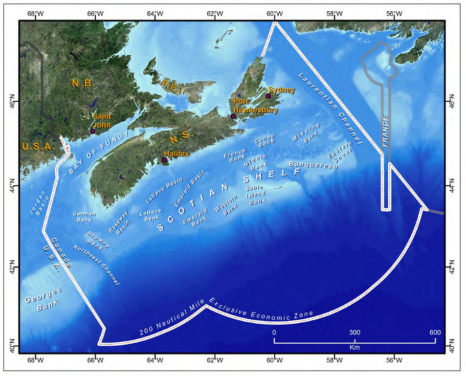
Figure 3: Underwater Features of the Scotian Shelf-Bay of Fundy Bioregion
Figure 3 is a map of the area covered by the Regional Oceans Plan with a number of underwater features labelled including things such as the major banks, channels, canyons and basins.
Georges Bank
Georges Bank is located in the offshore waters between southwest Nova Scotia and Cape Cod, Massachusetts. The international maritime boundary between Canada and the United States crosses Georges Bank, dividing the bank between the two countries. The Canadian portion accounts for less than 50% of its total area. Georges Bank is a shallow bank with approximately 50% of its area being shallower than 60 m (200 ft). It is a highly productive ecosystem with high levels of fish biomass and a diversity of other marine species. In addition to providing habitat for resident species, it is also an important over-wintering and staging destination for many migratory species during their southward and northward movements. It is the northern limit for many warm water species and the southern limit for many cold water species. Georges Bank is known around the globe as a significant fishing area. It is perhaps best known as one of the world’s most productive areas for sea scallops and represents some of the fastest observed growth rates for sea scallop stocks. Georges Bank also has significant petroleum resource potential. However, the bank has been subject to an oil and gas moratorium since 1988.
The Bay of Fundy
The Bay of Fundy is a narrow, funnel-shaped body of water, over 270 km long and 60 km wide at its widest point. It is known for its extreme tidal ranges.
The inner bay and outer bay have somewhat different characteristics, with the inner bay having the most extreme tidal ranges and extensive mudflats at low tide. Productivity in the area is exceptionally high and likely greatest at the mouth of the bay due to tidal mixing. Many different species take advantage of this productivity, including endangered North Atlantic right whales that feed on abundant copepods in the area during the summer and fall. An area in the Bay of Fundy near Grand Manan Island has been identified as critical habitat for this whale. The Bay of Fundy was Canada’s most popular nomination for the new Seven Wonders of the Natural World competition.
Socio-economic Context
The Atlantic Coast, the Offshore Scotian Shelf, and the Bay of Fundy support a diverse array of marine activities, including commercial fishing, shipping, oil and gas, aquaculture, telecommunications, defence and and research. Many of these activities are directly dependent on the marine ecosystem. Economic benefits from ocean activities are reported by province, rather than marine region, making it difficult to identify economic benefits from specific ocean areas. However, it is clear that the ocean industries conducted in the Scotian Shelf-Bay of Fundy bioregion make significant economic contributions to the Gross Domestic Products (GDPs) of Nova Scotia and New Brunswick (Figures 5 and 6). One of the aims of the Plan is to foster economically prosperous maritime sectors and communities by supporting marine activities carried out in a sustainable manner. As well, the Plan promotes communication between different industry sectors, particularly in cases of existing or potential conflict.
Climate Change
Climate change is a cross-cutting issue that will affect the natural environment of the bioregion from coastal regions to the offshore. These changes could in turn have profound impacts on many marine sectors, particularly those that rely on living resources. Climate change may result in different species becoming commercially important in fisheries or aquaculture. For example, fish species not currently common in our waters, such as bluefish (Pomatomus saltatrix) and black sea bass (Centropristis striata) may become commercially important. Species currently commercially important may decline in abundance. Changes in water chemistry may result in shellfish having weaker shells or spending more energy to develop shells.
A changing climate may also lead to changes in the suite of invasive species that live in our waters, or make our area more susceptible to invasive species and their impacts. Some marine plants and animals may become more stressed and thus more vulnerable to non-direct impacts from human activities. Adapting to a changing climate is something all management sectors will have to face in the coming years.
Fishing
Commercial fishing occurs in most areas for a variety of species. Three major species groups are fished commercially in the bioregion: groundfish (e.g., cod, haddock, pollock, redfish, flatfishes); pelagic fish (e.g., herring, swordfish, sharks, tuna); and shellfish (e.g., snow crab, lobster, scallop, shrimp).
The Bay of Fundy, Georges Bank and the western Scotian Shelf support important fisheries for scallop, lobster and groundfish. Lobster is important in coastal areas throughout the bioregion. The area from Digby to Shelburne supports the most productive lobster fishery in the country. The cool waters of the eastern Scotian Shelf support important crab, clam and shrimp fisheries.
Fisheries for swordfish and tuna occur in the deeper waters of the shelf edge and slope during the summer months.
The fishing industry has responded to much change over the last twenty-five years. The formerly dominant groundfish fisheries now occur mostly on the western
Scotian Shelf and in the Gulf of Maine. Across the bioregion, new species are being exploited and existing fisheries for many species of shellfish have expanded. Fish harvesters are increasingly sharing the offshore with oil and gas activities and coastal areas with aquaculture operations. Climate change is also expected to affect fisheries. In addition, fisheries management has changed, attempting to incorporate ecosystem considerations in managing fisheries, such as impacts on habitat and other species.
Shipping
Commercial shipping in the area is generally in the form of tankers, and general bulk and containerized cargo carries. Halifax, Port Hawkesbury and Saint John are the largest ports in the region. Servicing the cruise ship industry also provides important economic benefits to the region. The main ports of call for cruise ships are Halifax, Sydney and Saint John. Overall, maritime transport in Nova Scotia generates about $500 million annually in GDP, while in New Brunswick annual GDP is estimated at about $100 million. International agreements and national legislation controlling pollution from ships have long been in place, while ballast water management measures continue to evolve in accordance with international agreements and guidelines. The overall amount of noise in the marine environment, of which shipping is a major contributor, is a concern for some species, particularly whales. Recently, a federal risk assessment for marine oil spills identified several areas with relatively higher risks in the bioregion, including Saint John Harbour and the outer Bay of Fundy, and Chedabucto Bay and the adjacent eastern shore of Nova Scotia and Cape Breton.
Oil and Gas
Oil and gas exploration in the bioregion occurs mainly in the Offshore Scotian Shelf planning area around Sable Island. There are currently two offshore energy projects in production: Sable Offshore Energy and Deep Panuke. Sable Offshore has been producing natural gas since 1999 and has a total project life expectancy of about 25 years. It has been a significant source of revenues for the Province of Nova Scotia, which received $900 million from the project in 2008. Deep Panuke started natural gas production in the fall of 2013. A long-standing moratorium on oil and gas exploration exists for Georges Bank. After a brief lull in activities, there has been a recent resurgence in interest in exploring for oil, with much of this interest being directed to deep water areas off the Scotian Shelf. Shell and British Petroleum have recently made significant investments in deep water exploration license bidding processes. The corresponding increase in exploration activities, including seismic surveys and exploratory wells, requires effective coordination and communication among the oil and gas industry, regulators and other ocean use sectors. While a significant amount of research has been carried out on the impacts of oil and gas activities, more work is required in this area. Key risks associated with offshore hydrocarbon development include potential noise impacts on marine animals, disruption to fisheries, and pollutant discharges and oil spills.
Shipping Analysis for Better Decision Making
DFO works with other government partners to help monitor shipping- related activities and manage or mitigate associated environmental pressures. For example, various mapping projects have been completed and are underway to assess patterns and trends in vessel traffic, ballast water exchange, and vessel-sourced pollution (for example, see Figure 4). DFO also regularly contributes shipping- related information and expertise in support of decisions with respect to environmental assessments (e.g., vessel traffic patterns in relation to proposed marine terminals), marine protected area and species at risk management (e.g., endangered North Atlantic right whale Critical Habitat designation), and other marine zoning processes (e.g., ballast water exchange zone designation).
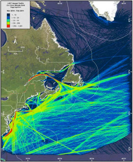
Figure 4: Vessel traffic densities in the Northwest Atlantic
Figure 4 is a map of the east coast of North America showing areas of greatest marine vessel traffic extending along the coast, into the St Lawrence River and across the Atlantic.
This map was created by counting the number of vessel tracklines within each 2 minute grid cell using 12 months (March 2010–February 2011) of Long Range Identification and Tracking
Renewable Energy
The Bay of Fundy planning area has been the focus of efforts to harness renewable tidal energy. There is currently one tidal power station in the bay. Seven locations have been identified as potential sites for tidal in-stream turbines on the Nova Scotia side of the bay, while eight sites have been identified on the New Brunswick side. In-stream technology remains at testing stage. Other parts of the bioregion have been identified as having high potential for wind and wave energy. As interest in this sector increases, it will be important to coordinate between this and other sectors, and to consider the environmental impacts of any renewable energy developments.
Aquaculture
Aquaculture in the Scotian Shelf-Bay of Fundy bioregion occurs in the Atlantic Coast and Bay of Fundy planning areas. New Brunswick has the largest aquaculture industry in eastern Canada and the second largest in Canada. The main species produced in the bioregion are Atlantic salmon and blue mussels, with most of the value coming from salmon farming. Additional farmed species include rainbow trout, American oyster, bay quahog and Arctic char. The total value of the aquaculture industry in Nova Scotia and New Brunswick in 2012 was about $244 million. The Plan will support DFO’s efforts to promote intergovernmental cooperation and planning and stakeholder involvement in aquaculture.
Tourism
Most marine tourism activities occur in coastal areas of the bioregion. Sport fishing, boat tours, whale watching, kayaking, diving, surfing and beach visits are all aspects of the tourism industry that depend on the region’s marine and coastal environments. Cruise ship tourism is described in the shipping section above, with expenditures by passengers and crew captured under the “Tourism” category of Figures 5 and 6. Cruise ship expenditures were estimated at $20-$30 million in the early 2000s; however, with increased cruise ship visits in the 2010s, current expenditures are likely to be higher.
Tourism in the Gully and on Sable Island
When the Gully was first established as an Oceans Act MPA, it was considered to be so far offshore that tourism was a minor consideration in its management plan. But the establishment itself has brought increased interest to the area, and there have been requests by eco-tourism operators to visit the area. The establishment of nearby Sable Island as a National Park Reserve by Parks Canada is also likely to increase tourism interest. Parks Canada and DFO will work together to make sure increased visitors do not negatively impact the ecosystem of these important habitats.
Land-based activities
Land-based activities, ranging from electrical generation to manufacturing to municipal wastewater systems to agricultural activities, have an impact on water, sediment and air quality of the marine environment. Distant sources of pollution affect the Scotian Shelf due to transport from the St. Lawrence River and Gulf of St. Lawrence and deposition from the atmosphere. In fact, pollution from local sources is considered to be a less important source of contaminants on the Scotian Shelf than distant sources. While pollution, eutrophication and hypoxia are mostly a concern in coastal waters, particular oceanographic conditions or activities occurring in certain areas of the offshore may require attention.
Marine debris, often from land-based sources, are an entanglement and ingestion threat for many species. Micro-plastics, which are minute particles of plastic that are easily ingested by marine life, are of increasing concern.
Jurisdictional Context
Federal, provincial and municipal governments all have a role to play in the management of marine and coastal environments. The Scotian Shelf-Bay of Fundy bioregion is shared by the Provinces of Nova Scotia and New Brunswick, each with multiple municipal governments established within them. The southern extent of the bioregion is delimited by the maritime boundary with the United States in the Gulf of Maine and the French Exclusive Economic Zone for St. Pierre et Miquelon also extends into the eastern bioregion. Within each of these levels of government, numerous departments and agencies are in place to oversee applicable oceans and coastal policy and legislation.
Jurisdictional authorities for the various levels of government in Canada are assigned in the Constitution Act, 1982. Section 35 of the Constitution Act also recognizes and affirms the existing Aboriginal and treaty rights of the Aboriginal peoples of Canada. DFO, as a representative of the Crown, seeks to carry out its mandate in a manner that is consistent with the constitutional protection provided to Aboriginal and treaty rights and decisions of the Supreme Court of Canada in R. v. Sparrow and subsequent decisions. In Nova Scotia, DFO consults First Nations through various means including the Mi’kmaq-Nova Scotia-Canada Terms of Reference for a Consultation Process under the Assembly of Nova Scotia Mi’kmaq Chiefs. Similarly, in New Brunswick, DFO consults First Nations through various means including the Mi’gmag, Wolastoqiyik, New Brunswick, and Canada Interim Consultation Protocol under the Assembly of New Brunswick First Nations’ Chiefs. DFO consults with First Nations when departmental management decisions have the potential to affect First Nations communities, but also more broadly to share information and views with respect to matters that affect aquatic resources and oceans management. DFO also engages other Aboriginal
Organizations in these processes including, the Native Council of Nova Scotia, Unama’ki Institute of Natural Resources, Maritime Aboriginal Peoples Council, and Atlantic Policy Congress of First Nations Chiefs. These engagements may include the collection and consideration of traditional knowledge in departmental assessments, planning and management.
DFO participates on intergovernmental bodies with other federal departments, such as Environment Canada, Transport Canada, Natural Resources Canada and Parks Canada, as well as numerous provincial departments from Nova Scotia and New Brunswick. The primary oceans-related governance structure for the bioregion is the Maritimes Provinces Regional Committee for Coastal and Ocean Management. Within the Gulf of Maine, DFO participates on the Gulf of Maine Council on the Marine Environment and in a transboundary fisheries assessment and management process for stocks shared with the United States. Given this complexity of jurisdictions, a collaborative approach is required to work toward common priorities under the existing authorities and utilize resources most effectively.
Nova Scotia oceans sector GDP impact, 2006 ($ millions)
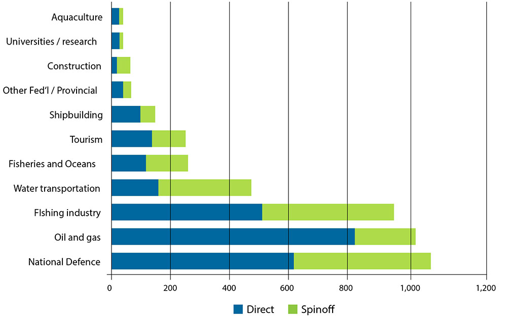
Figure 5: Economic Impact by Ocean Sector (2006) in Nova Scotia (Gardner, M., MacAskill, G., and DeBow, C. 2009.
Figure 5 is a bar graph of the GDP impact (direct and spinoff) of various marine sectors in Nova Scotia including sectors such as aquaculture, tourism, fishing, National Defence.
Economic Impact of the Nova Scotia Ocean Sector 2002-2006. Prepared for Fisheries and Oceans Canada and Nova Scotia Government. 27 pp + appx.)
New Brunswick oceans sector GDP impact, 2008 ($ millions)
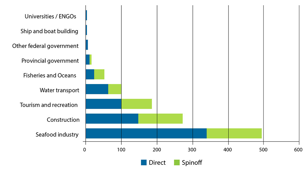
Figure 6: Economic Impact by Ocean Sector (2008) for New Brunswick (Gardner, M., and MacAskill, G. 2010.
Figure 6 is a bar graph of the GDP impact (direct and spinoff) of various marine sectors in New Brunswick including sectors such as ship building, tourism and recreation and the sea food industry.
Economic impact of the New Brunswick ocean sector 2003-2008. Gardner-Pinfold Consulting Economists Ltd., Halifax, Nova Scotia). Seafood industry category includes fishing and processing; values are for Bay of Fundy and Gulf of St. Lawrence.
Oceans and Coastal Management
The aim of the Oceans and Coastal Management component of the Plan is to support and improve planning, management and decision making in the marine environment. This is done through the prioritization of oceans and coastal management issues, provision of knowledge, assessment and advisory products, and collaboration with others to solve management problems. DFO undertakes an ongoing issue assessment and prioritization approach to direct research, assessments and management actions by the department and others with a mandate for oceans and coastal management. This work includes the consideration of issues identified through ongoing work in the field, knowledge of existing and planned marine development activities (e.g., offshore oil and gas, renewable energy etc.), engagement with the scientific community, government partners and stakeholders, and from international and national reports and studies on oceans-related topics. For example, information on bioregional status and trends from the State of the Scotian Shelf and State of the Gulf of Maine reports are used to inform planning and management. This prioritization approach also provides direction for and is supported by geospatial analysis and products, such as maps of human activities and ecological features.
Underpinning this work is the application of risk management approaches to assess, evaluate and respond to pressures and impacts. This is essential to ensure that departmental actions are targeted against well-defined and agreed upon priorities. Because the determination of risk involves a good understanding of often multiple pathways of effects among activities, pressures and receiving environments, ongoing collaboration within DFO and with other experts is required.
The Plan places a strong emphasis on well-informed and effective decision making for oceans and coastal management. Critical to supporting effective decision making is ensuring that sound information is available to those who need it in a timely manner and in accessible formats that can be readily used. To this end, DFO is working to develop a suite of planning, assessment and decision support tools, including marine spatial data, maps and information products, operational guidance and knowledge products, and relevant information on the status and trends of priority issues, needs and gaps in the bioregion.
Risk Management Approaches to Oceans and Coastal Management
Canada, along with over 30 nations, has adopted ISO 31000:2009 as its standard for the conduct of risk management. DFO has been working to incorporate risk management approaches using this standard within its program areas. The basic premise of risk management is to evaluate the potential impacts of certain activities against the likelihood of occurrence in order to direct efforts where they are most needed. ISO 31000:2009 outlines a process of managing risk based on a series of steps. These steps include establishing the context of the analysis, such as social, economic and cultural factors; identifying risks, including the sources and potential consequences; analyzing risks to better understand them in terms of drivers and potential mitigation; evaluating risks to review risk levels and determine required responses; treatment of risk to select options to reduce the risks; as well as steps to communicate, consult, monitor and review.
Marine Spatial Information and Analysis
DFO recognizes the importance of a spatial and temporal approach to oceans and coastal planning and management. Pragmatic and operational approaches to spatial planning and management can provide effective, flexible and adaptive solutions for management problems. This approach is also the most effective way to advance DFO’s priority for the development of practical methodologies for cumulative impact assessments, such as through the analysis of zones of influence and pathways of effects.
A longer-term objective under the Plan is to develop accessible and web-based mapping products and decision support tools to facilitate risk assessment, cumulative impact assessment, and constraint and compatibility mapping.
Marine geospatial data and information are core elements in the development of knowledge products for effective planning, management and decision support. Spatial knowledge products include maps, GIS files, analytical methodologies, inventories, digital atlases, and fact sheets.
Mapping the spatial distribution and intensity of human activities and ecological data at relevant planning scales has many applications, including:
- Identifying, assessing and mitigating human use conflicts and constraints
- Providing assessments and decision support for marine development activities
- Informing federal and provincial environmental assessment processes
- Conducting use intensity and cumulative impact assessments
- Supporting government partners, industry and project proponents by providing information related to fisheries and others uses, ecosystem sensitivities and potential impacts
- Providing information and advice for regional fisheries assessments, Integrated Fisheries Management Plans, and Marine Stewardship Council eco-certification processes
- Informing risk assessments for Species at RIsk Act (SARA) listed species, MPAs and other marine conservation areas
- Developing scenarios and options for meeting MPA and other conservation objectives at bioregional and site-specific scales
- Monitoring compliance and threats in MPAs and conservation areas
- Supporting the implementation of departmental management priorities, such as the Sustainable Fisheries Framework and SARA critical habitat identification
- Informing environmental preparedness, response and recovery operations
Data acquisition is an ongoing process to support the mapping of coastal and offshore human use and marine ecosystem attributes across the bioregion. The Plan promotes the use of validated spatial data, maps and analytical methods for addressing human use and ecosystem interactions. Human use and ecological data layers can be analyzed with appropriate techniques and combined in multiple applications for decision support, constraint and compatibility mapping, cumulative impact assessments, and conservation planning. As part of this, DFO will continue to work with other regulators, users and interests to collect and validate spatial data and products. Key spatial datasets maintained by DFO include the following:
- Commercial, Aboriginal and recreational fisheries
- Marine infrastructure (e.g., submarine cables, pipelines and oil and gas production facilities)
- Oil and gas exploration licences and prospective areas
- Shipping routes and vessel usage
- Renewable energy potential (e.g., wind, wave and tidal)
- Aquaculture leases and prospective areas
- Coastal land uses
- Areas of conservation value, such as Ecologically and Biologically Significant Areas (EBSAs), coral and sponge areas, SARA critical habitat, and other significant area designations
- Marine science and research surveys
- Marine fish and wildlife distributions and habitats
- Existing marine management and jurisdictional areas
- Provincial parks and beaches
- Watershed boundaries
- Coastal shorelines and wetlands
- Invasive species distributions and risk areas
- Canadian Shellfish Sanitation Program classification areas
- Point and non-point pollution sources, incidents and risk areas (e.g., oil spills, sewage effluent discharges, and dredge disposal sites)
Assessing Tidal Energy Development Constraints in the Bay of Fundy
Figure 7 illustrates some of the overlapping ocean uses and conservation priorities in the context of 16 potential tidal energy sites identified in the Bay of Fundy. Marine spatial planning can help resolve tidal energy development options through identification, awareness raising and potential avoidance of spatial and temporal ocean use conflicts throughout the Bay. Map overlays include several marine protection priorities such as North Atlantic right whale critical habitat, the Musquash Estuary Marine Protected Area, and several well-known Ecologically and Biologically Significant Areas. Coastal aquaculture sites occur on both sides of the bay, supporting an active local marine economy in Nova Scotia and New Brunswick. The bay is a very productive area for multiple fisheries that would blanket the map if all fishing activities were displayed; included here are only sea scallop and groundfish landings as symbolized in the legend. Commercial shipping routes into Saint John Harbour are illustrated by two dominate vessel traffic patterns at the entrance to the bay. In terms of seabed infrastructure, an active submarine telecommunications cable crosses the area at mid-bay.
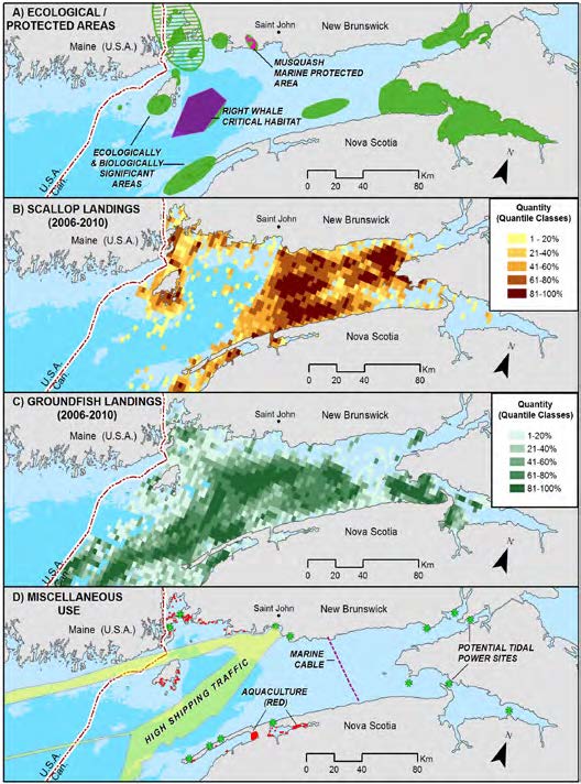
Figure 7: Overlapping Activities and Priorities in the Bay of Fundy
Figure 7 is a composite of 4 maps of the Bay of Fundy to illustrate the overlapping uses and conservation priorities in the Bay. The maps illustrate ecological and protected areas, scallop landings, groundfish landings, and other uses including shipping routes, aquaculture sites, marine cables and potential tidal power sites.
Operational Guidance and Knowledge Products
Spatial analysis and other information sources can also be used in the development of operational guidance and knowledge products. These are practical tools and guides for users of the marine environment to ensure that activities are undertaken in a manner to sustain the key ecosystem attributes present and minimize conflicts with other users. Examples of some operational guidance and knowledge products include the following:
- National-level pathways of effects models for activities, such as seismic exploration, exploratory drilling, shipping and aquaculture
- Guidance fact sheets, industry statements of practice, development standards and best management practices
- Marine environmental quality guidelines and criteria
- Mapping products for MPA and conservation planning, and for Marine Stewardship Council conditions of sustainability for certified fisheries
- Coastal and marine inventories for environmental emergency preparedness and response operations, and environmental assessments and reviews of marine developments and activities
- Risk assessment and management guidance for regional EBSAs, including site profiles with mitigation measures for various human activities
Under the Plan, opportunities will continue to be pursued to develop operational guidance products targeted at the key priorities.
Guidance for Improved Coastal Management: Land Development Standards for the Bras d’Or Lakes Watershed
The Bras d’Or Lakes in Nova Scotia is a unique estuary at the heart of Cape Breton Island. The estuary, coastal waters, and numerous freshwater rivers and streams have sustained generations of people, beginning with the Mik’maq, whose growing communities continue to rely on its natural resources. In recent years however, the health of the Bras d’Or has diminished from anthropogenic pressures such as overfishing, the introduction of invasive species, forestry, sewage inputs, and poor land development practices. To help address impacts from ongoing and future land development, the Bras d’Or Collaborative Environmental Planning Initiative (CEPI) undertook work to provide guidance in this area. Assessing a gap in the current management regime, the CEPI worked to examine and develop land use standards that could be adopted by the municipal level of government. These standards would help reduce the impacts from existing development which could proceed in a manner largely unregulated. A series of best management practices (BMPs) were examined and proposed based on their suitability for the Bras d’Or Lakes related to minimizing impacts to surface and marine waters, wetlands, shorelines and groundwater, and to minimize impacts from sea-level rise. These BMPs were developed in the language and form of municipal government policy for easy incorporation into their Municipal Planning Strategy and Land Use Bylaws. They were also supported by GIS analysis, mapping and educational material. Work is ongoing to support adoption of these guidelines by the four municipalities that form part of the Bras d’Or Lakes watershed.
To compliment this work, the Unama’ki Institute of Natural Resources, in partnership with CEPI, undertook similar efforts within the five First Nation communities that are located on the shores of the Bras d’Or. Building on the Best Management Practices (BMPs) chosen, the UNIR developed a community based educational program for coastal protection and management with emphasis on sustaining the important species and habitats familiar to and used by the First Nation communities.
The efforts and operational guidance products developed in the Bras d’Or can serve as a resource to the many other coastal areas in the Maritimes Region where additional land development controls are needed.
Bioregional Assessment and Reporting
Informed planning and decision making requires up-to-date information on the ocean ecosystem and the activities that occur within it. DFO draws upon a variety of information sources and expertise from within the department, as well as other organizations with knowledge and information about oceans-related trends and status in the bioregion.
The information contained in the State of the Ocean Reports supports a number of applications, including environmental assessment and management, research and education. For the purpose of the Plan, this series of theme papers can help inform priority setting for various actions to address outstanding issues, trends, or gaps in knowledge.
One area of assessment where DFO is working is with Ecologically and Biologically Significant Areas (EBSAs). EBSAs are areas that have been identified through a formal assessment as having special biological or ecological significance when compared with the surrounding marine ecosystem. DFO has identified a number of EBSAs in the coastal and offshore portions of the bioregion. These areas are to be managed with a corresponding and greater degree of risk aversion. To date, EBSAs have been used primarily to inform environmental assessments of proposed marine developments and activities and will be considered in bioregional MPA network planning and the application of the department’s Sensitive Benthic Areas Policy for sustainable fisheries management. DFO is also undertaking a systematic review of regional EBSAs to identify priorities for site profile development. Profiles will include an assessment of relevant risks, recommended mitigation and protection measures, and practical information and operational guidance for the management and use of the site. The intent is to prioritize profile development for EBSAs that are most likely to be affected by existing or future activities, as well as those areas deemed to be particularly vulnerable or at risk. This process will also provide important inputs to regional MPA planning by identifying management and protection gaps.
In addition to the assessment of EBSAs and the State of the Ocean Reports, DFO will continue to support and use scientific research on ecosystem and biological features and processes. This includes information generated through the department’s Canadian Science Advisory Secretariat (CSAS) process, and through long- standing research surveys, such as the Atlantic Zonal Monitoring Program (AZMP) and fisheries research trawl surveys. Similarly, DFO’s ongoing tracking, analysis and mapping of ocean uses and management issues will contribute to the setting of departmental priorities. Research and assessments prepared by other government departments, Aboriginal organizations, conservation and community groups, marine industry, and academic institutions provide other important inputs to the state of knowledge of the bioregion and its oceans and coastal management priorities.
State of the Ocean Reporting: Assessing Bioregional Issues, Trends and Priorities
DFO has supported the development of State of the Ocean Reports to provide a detailed look at the ecosystem, human activities, and emerging issues for defined ocean areas. DFO has worked in collaboration with other government and non-government partners to complete two reports covering the bioregion: State of the Scotian Shelf and State of the Gulf of Maine. These reports provide information on important ocean issues and trends to a broad range of audiences in a format that is accessible and easy to understand. The reports are modular, web-based documents made up of an introductory context document and a series of theme papers. The context documents provide overview and background information, while the theme papers provide a more in-depth look at important issues within each area. Consistent formats for the theme papers provide an overview of the issue and a description of driving forces and pressures, status and trends, impacts, actions and responses, and references.
State of the ocean context documents and theme papers include:
Scotian Shelf
- Biodiversity
- Marine Habitats and Communities
- Incidental Mortality
- Species at Risk
- Invasive Species
- Productivity
- Primary and Secondary Productivity
- Trophic Structure
- Fish Stock Status and Commercial Fisheries
- Marine Environmental Quality
- Water and Sediment Quality
- Ocean Noise
- Waste and Debris
- Ocean Acidification
- Other
- Climate Change and its Effects on Ecosystems, Habitats and Biota
- Emerging Issues
Gulf of Maine
- Climate Change
- Climate Change and Humans
- Climate Change and its Effect on Ecosystems, Habitats and Biota
- Fisheries and Aquaculture
- Commercial Fisheries
- Coastal Development
- Coastal Land Use and Development
- Contaminants
- Toxic Contaminants
- Microbial Pathogens and Toxins
- Eutrophication
- Eutrophication
- Aquatic Habitats
- Coastal Ecosystems and Habitats
- Offshore Ecosystems and Habitats
- Watershed Status
- Other
- Invasive Species
- Species at Risk
- Emerging Issues
Reports
The complete list of reports can be accessed at:
Marine Protected Area Planning and Management
Under the Oceans Act, DFO is responsible for designating and managing Marine Protected Areas (MPAs) and for leading the development of a national network of MPAs. In the Maritimes Region, the Gully MPA and Musquash Estuary MPA have been designated and the St. Anns Bank has been identified as an Area of Interest. Two Coral Conservation Areas and two Sponge Conservation Areas as well have also been established, along with a variety of other area-based conservation measures (Figure 8). With the protected areas described above in place, DFO is initiating a planning process to develop an MPA network plan for the Scotian Shelf-Bay of Fundy bioregion.
Marine Protected Area Network
Canada has made several international and domestic commitments to establishing networks of MPAs. Most recently, the 2010 meeting of the Convention on Biological Diversity (CBD) signatory countries established targets for marine protection. Domestic commitments have been made through the Oceans Act, Canada’s Federal Marine Protected Areas Strategy (Government of Canada 2005), and the federal Health of the Oceans (HOTO) Initiative, which led to the development of the National Framework for Canada’s Network of MPAs. The Framework is a shared federal, provincial and territorial policy document that provides strategic direction for the planning and implementation of the national network.
In addition to DFO’s Oceans Act MPAs, National Marine Conservation Areas (Parks Canada) and Marine Wildlife Areas (Environment Canada) may also contribute to a federal network of protected areas. Migratory Bird Sanctuaries, National Wildlife Areas and National Parks with a marine component, as well as cerain existing area- based conservation measures, such as fisheries closures, may also considered important contributors to this network.
For MPA planning, Canadian waters have been divided into 13 bioregions. The long-term intent is to have separate but linked networks in each bioregion. The Scotian Shelf-Bay of Fundy bioregion and its three planning areas for the Offshore Scotian Shelf, Atlantic Coast and Bay of Fundy, provide the basis for both conservation planning and broader oceans and coastal management efforts by DFO.
As the lead agency, DFO is working closely with its federal (Environment Canada and Parks Canada) and provincial (Nova Scotia and New Brunswick) partners to advance MPA network planning. The major steps in the planning process are as follows:
- Identify and involve interested parties (government agencies, Aboriginal groups and stakeholders)
- Compile available information
- Set network objectives
- Identify areas of high conservation value
- Consider social, economic and cultural values
- Create a network action plan
- Undertake site-specific planning and implementation
- Monitor, manage and report
This initiative will build on past regional conservation planning activities, including efforts to engage stakeholders, compile data, and identify EBSAs and other important conservation priorities. Considering this past work, significant progress has been made on the first three steps over the last decade.
DFO is initiating the multi-year MPA network planning process through targeted engagement with all relevant government agencies, Aboriginal groups and stakeholders, as well as with the public. Technical work is underway to develop conservation objectives, compile data, and explore potential MPA network design scenarios will continue throughout the planning process. A major milestone is to produce an action plan that specifies the priority areas for protection within the bioregion. This will serve as the basis for selecting any new MPAs in the bioregion and will be adapted over time as new information becomes available.
Using EBSAs in MPA Network Development
The analysis required to design a network of MPAs requires careful consideration of the full range of ecosystems, discrete areas of high ecological importance, current and past human use, economic and cultural significance, and the various user groups and interested parties involved. To this end, data is being compiled and analyzed by DFO to develop a clear and common understanding of these elements. This information will be vetted as appropriate through relevant government departments and with stakeholders.
Among the key sources of information to be used in MPA network planning are sites identified as Ecologically and Biologically Significant Areas (EBSAs). These are areas that have been identified by DFO as playing a particularly significant role in certain ecosystems or communities based on the five criteria of: uniqueness, aggregation, fitness consequences, resilience and naturalness. Multiple EBSAs have been identified throughout the three bioregional planning areas, including sites that may be required for important life history stages such as spawning, rearing, feeding, and migration. Further work and analysis will be undertaken under the Regional Oceans Plan to better delineate EBSAs, assess threats, and identify appropriate management actions. Not all EBSAs will be protected within the network of MPAs. For those sites where MPA designation is not the best management option, other instruments and measures may be pursued if there is a need for additional protection. These measures might include the development of marine environmental quality (MEQ) guidelines, sector-specific standard operating procedures, the development and application of best management practices, other area-based conservation measures, such as area closures or gear restrictions, as well as other voluntary or regulatory approaches.
Management of Marine Protected Areas and Conservation Areas
As the lead federal authority for Oceans Act MPAs, DFO has overall responsibility for ensuring that conservation measures are respected and enforced in these sites. MPA management involves a number of activities, including developing, implementing and updating management plans, developing ecological monitoring plans and undertaking scientific monitoring and research, managing human activities pursuant to existing legislation and activity plans, developing further policies and guidelines where needed, preparing education and outreach material, coordinating effective and timely enforcement and compliance, and performance reporting.
Oceans Act MPAs
There are two Oceans Act MPAs and one Area of Interest in the Maritimes Region as described below.
The Gully Marine Protected Area
Located off Nova Scotia near Sable Island, the Gully contains a rich diversity of marine habitats and species, including deep-sea corals and an endangered population of northern bottlenose whales. It is also the largest submarine canyon in the western Atlantic Ocean. The Gully MPA was designated in 2004 and encompasses an area of 2,364 km². The Gully Advisory Committee, which is comprised of a range of government agencies and stakeholders, meets regularly to provide guidance on management issues.
For more information on the Gully MPA, visit The Gully MPA.
The Gully MPA: Integrated Management in Practice
The day-to-day management of the Gully MPA requires on-going implementation of integrated management practices, including coordination and collaboration both within government and with external interests. Collaboration and partnering arrangements have allowed MPA managers to access and leverage a range of statutory control mechanisms, voluntary measures and pre-existing data collection and surveillance programs. For example, fisheries management tools are applied to protect the MPA against fisheries-related impacts. These tools include licence conditions that restrict fish harvesting in the site, and surveillance and compliance monitoring mechanisms (e.g., satellite-based vessel monitoring, logbooks, aerial surveillance patrols and observer reports) to ensure fisheries restrictions are obeyed. Nearby oil and gas exploration and developmental activities are managed in co-operation with the petroleum regulator and industry representatives. Ballast water exchange management and monitoring is addressed in collaboration with Transport Canada, and marine pollution is monitored via satellite and aerial surveillance patrols through a Transport Canada - Environment Canada partnership. Other federal agencies that play a role in protecting the MPA include the Canadian Coast Guard, which provides support through its emergency response and vessel traffic surveillance programs, and the Department of National Defence, which performs aerial and vessel-based surveillance patrols when transiting near the MPA. As well, scientific partnerships with universities and enhanced effects monitoring by industry have contributed significantly to our understanding of the MPA ecosystem and its threats.
Musquash Estuary Marine Protected Area
Musquash Estuary MPA is located in the Bay of Fundy approximately 20 km southwest of Saint John, New Brunswick. The MPA, designated in 2006 and covering an area of 7.4 km², encompasses a productive estuary and salt marsh habitats which provide habitat for many species of fish, invertebrates and marine plants. DFO also administers an additional 4.0 km² of intertidal lands and waters in the estuary as part of the MPA, known as the Administered Intertidal Area (AIA).Footnote 1 The estuary is one of only a few that remains in the Bay of Fundy that has not been significantly impacted by human development. The Musquash Advisory Committee, which includes a broad range of interests, meets regularly to review and offer direction on management issues.
For more information on the Musquash Estuary MPA, visit Musquash Estuary Marine Protected Area (MPA).
St. Anns Bank Area of Interest
Located off Eastern Cape Breton Island, Nova Scotia, the St. Anns Bank Area of Interest (AOI) is in the process of designation as an Oceans Act MPA. The AOI, is an ecologically significant area that encompasses important habitat for several commercial and non-commercial species, including species at risk (e.g. Atlantic wolffish, Atlantic cod), unique habitats, and an area of high fish diversity. An ecological risk assessment was developed for the AOI to establish the relative risk of interactions between the conservation priorities for the future MPA and several human activities. The risk assessment combined the consequence of an event (i.e., predicted impact of an interaction) with the likelihood of its occurrence. The findings of the risk assessment contributed to decision making on activities that will be allowed under the future MPA regulations and also informed the design of the boundary and limited fishing zones. Upon designation, St. Anns Bank will be managed in accordance with site management plan provisions and with the involvement of a multi-stakeholder advisory committee.
For more information on St. Anns Bank MPA, visit St. Anns Bank Marine Protected Area (MPA)
Coral and Sponge Conservation Areas
In addition to these MPAs, there are two areas that have dense concentrations of one or more deep-sea coral species and are managed as Coral Conservation Areas (CCA). The first Sponge Conservation Areas (SCA) in the Maritimes Region has also been recently established for a rare type of glass sponge off Nova Scotia. The purpose of these areas is similar to that of MPAs in that ecological features are being protected through restrictions on human activities. However, these areas have been established as fisheries closures under the Fisheries Act instead of the Oceans Act in order to deal directly with fisheries impacts. Brief descriptions of the coral and sponge conservation measures are provided below:
Northeast Channel CCA
This area, located off the southwest coast of Nova Scotia, was established in June 2002 through the Fisheries Act to protect high densities of bubblegum (Paragorgia arborea) and seacorn (Primnoa resedaeformis) coral. The CCA is 424 km², 90% of which is closed to all bottom fishing.
Lophelia CCA
This area, located southeast of Cape Breton, was established through the Fisheries Act in September 2003 and covers an area of 15 km². The CCA protects one of the only known colonies of Lophelia pertusa in eastern Canada and is completely closed to all bottom fisheries. There is also a restriction by the Canada-Nova Scotia Offshore Petroleum Board on oil and gas exploration in the area.
Vazella pourtalesi SCA
The large aggregations of sponges on the eastern Scotian Shelf represent globally unique and fragile sponge grounds. In an effort to help conserve and protect these areas, they have received protection under the Sensitive Benthic Areas Policy of DFO’s Sustainable Fisheries Framework. The total closure amounts to 259 km² and include two separate boxes to cover known distributions of the sponges. It prohibits any type of fishing gear that contacts the sea floor including drags, traps and bottom-set trawls.
Ongoing priorities for the coral and sponge conservation measures are to implement monitoring plans, coordinate and monitor scientific research, conduct full fisheries reviews, examine boundary issues, and to implement the protections measures through relevant Integrated Fisheries Management Plans and fishing license conditions.
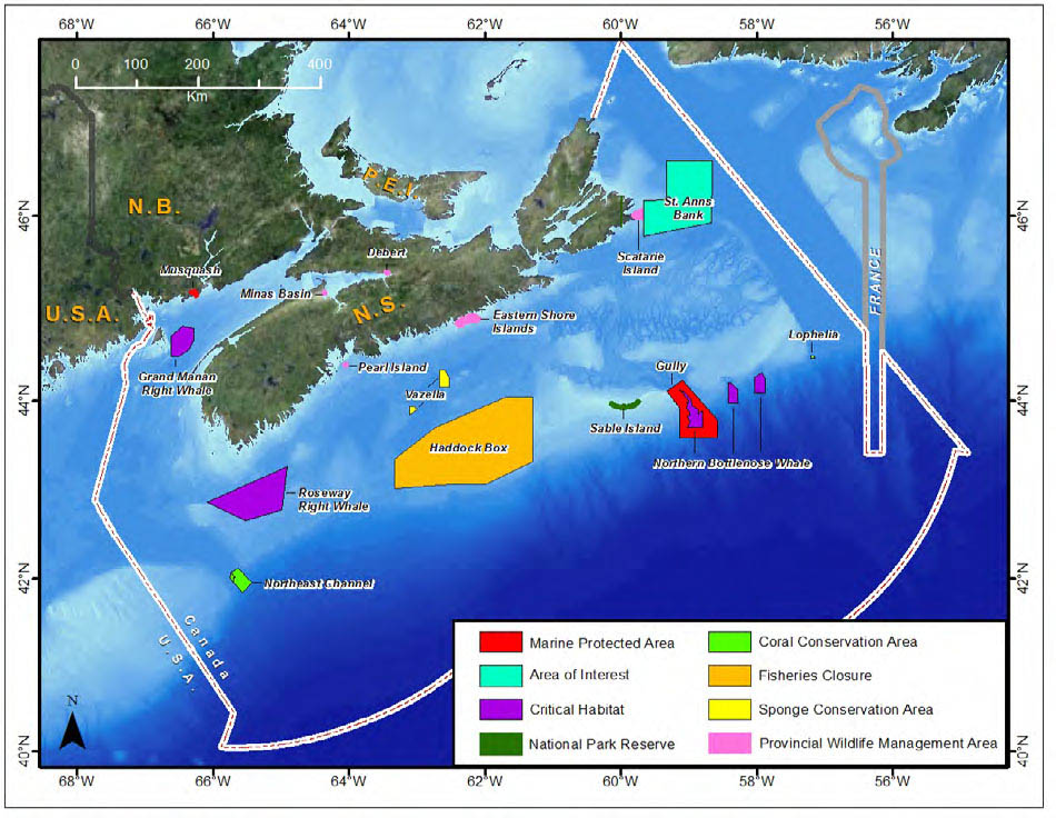
Figure 8: Marine Protected Areas and other key conservation areas in the Maritimes Region
Components of the Driving Forces, Pressure, State, Impacts and Response (DPSIR) Model used in State of the Ocean Reports: Figure 8 illustrates the relationships between driving forces, pressures, state, impacts and responses as considered within the State of the Ocean Report Series.
Collaboration and Engagement
Collaboration is fundamental to the Oceans Act to ensure multiple perspectives, knowledge sources and approaches are utilized when managing Canada’s ocean and coastal spaces.
Collaboration is especially important given the wide range of marine managers, users and interests within the Maritimes Region. The Plan recognizes the importance of strong internal aliignment within DFO and continues to support collaboration with other government departments, Aboriginal organizations and stakeholders using a variety of mechanisms and processes.
Departmental
A collaborative or “whole of DFO” approach to decision making and policy implementation is the most effective and efficient way to meet departmental strategic outcomes. A key goal for the Plan is to achieve coordinated, consistent and coherent approaches across the department when developing policies, implementing programs and taking decisions within the marine environment. Internal coordination and alignment helps DFO respond to external partners and stakeholders with one voice on a range of cross-cutting issues, such as oil and gas exploration and development, marine renewable energy development, aquaculture siting, conservation planning, and environmental assessments.
Further, there are a number of policy initiatives and strategies being implemented by DFO that require collaboration and input from multiple sectors within the department. These include activities related to the following:
- Maritimes Region Ecosystem Approach to Management (EAM) Framework
- Policies under the Sustainable Fisheries Framework
- SARA recovery and action planning
- Sustainable Aquaculture Strategy
- Fisheries management and protection
- Climate change research, risk assessment and adaptation
- Ecosystem science research and advice
- Geospatial data management and mapping
- Environmental incident preparedness and response
Internal alignment by DFO sectors helps identify the type of information needed to inform decisions. This allows the department to identify and consolidate the information typically required by its decision makers into readily accessible knowledge products. This work relates to the goal for effective decision making and is a priority under the Plan.
Within DFO, the Oceans and Coastal Management Division provides products, such as maps, data and risk assessments, that help in the implementation of departmental policies, strategies and management measures. The division also supports efforts to better coordinate activities related to policy and management integration, such as processes for ensuring that all departmental interests and responsibilities are addressed during the review of marine-related projects and activities.
In addition to effective coordination and alignment, the Plan places an emphasis on the incorporation of ecosystem approaches to management (EAM) in departmental policies, programs and operations. Within the Maritimes Region, DFO is advancing this through its EAM Framework which lays out a common structure with consistent terminology and definitions. This will foster a clearer understanding and uniform application of EAM across the various sectors of the department. A number of departmental sectors are actively working to understand and apply this approach to their operations. Resource Management was among the first in DFO to incorporate this approach into its program, specifically within the structure of Integrated Fisheries Management Plans and through the advancement of the Sustainable Fisheries Framework. Ecosystem Management, which includes the Oceans and Coastal Management Division, Species at Risk Management Division and Fisheries Protection Program, serves as the current regional lead for the EAM Framework and has advanced the approach through various management initiatives. For example, the risk assessment and management analysis process for bioregional EBSAs uses the organizing principles of the EAM Framework. Oceans and Ecosystems Science has provided much of the scientific basis and rigour for the EAM Framework and has adopted it as an organizing principle for its research prioritization and assessment processes.
DFO’s Sustainable Fisheries Framework: Departmental Collaboration at Work
DFO’s Resource Management sector aims to provide Canadians with a sustainable fishery resource that supports an economically viable and diverse fishing industry. Delivery of the programs is guided by the Sustainable Fisheries Framework. The Framework consists of a set of policies on the conservation and sustainable use of the fishing resource and a set of tools for helping Resource Management implement the policies. This implementation requires the engagement and input of several DFO sectors, including Oceans and Ecosystems Science, Policy and Economics, and Ecosystem Management. The following policies and tools are in place to guide the regional implementation of the Sustainable Fisheries Framework:
Integrated Fisheries Management Plans (IFMPs)
One of the main tools under the Framework is the IFMP. IFMPs are developed to manage the fishing of a particular species in a particular region. They provide a planning framework for addressing the impacts of the fishery on both target species and non-target species, as well as significant impacts the fishery might have on habitat.
The Ecosystem Approach to Management (EAM) Framework
The EAM Framework has been incorporated into the Region’s IFMPs with the expectation that once incorporated into the business of other management sectors, it will help DFO understand the cumulative effects on the ecosystem from various human uses, and ultimately the implications of cumulative effects for fisheries management strategies.
Precautionary Approach (PA) Policy
The PA Policy applies where decisions are made on harvest strategies or harvest rates for stocks that are targeted by a fishery. The policy requires that precautionary decision-making frameworks be developed that include reference points linked to stock and ecosystem indicators and harvest control rules. Work is ongoing to refine and expand PA frameworks in the Region’s IFMPs, including incorporating socio-economic considerations where appropriate, and to implement rebuilding plans for stocks that are below or approaching limit reference points.
Sensitive Benthic Areas (SBA) Policy
The purpose of the SBA Policy is to help manage fisheries in a manner that mitigates the impacts of fishing on sensitive benthic areas or avoids impacts of fishing that are likely to cause serious or irreversible harm to sensitive marine habitat, communities and species. Up-to-date fishing maps developed in support of conservation planning and oceans and coastal management are also facilitating the assessments of the cumulative impact of fishing on these sensitive areas. Assessments of regional EBSAs with potentially sensitive bottom features are also being used to support the continued application of the policy. Spatial protection measures, such as the sponge conservation area, that result from this policy represents important contributions to the bioregional MPA network.
Policy on Managing Bycatch
A policy on bycatch has been developed under the Framework. Priorities for managing the risks associated with bycatch are being addressed through two processes. The first is on a fishery-by-fishery basis through the development of IFMPs. Under the IFMP process, two species and fishery-specific plans for addressing priority bycatch species have been developed: the Workplan to Address Incidental Catch in Canadian Large Pelagic Fisheries; and the Atlantic Canadian Loggerhead Turtle Conservation Plan. The second process to address bycatch is on a cross-fishery basis under the Regional Bycatch Action Plan. Under this initiative, estimates of discards from commercial fisheries were developed and reported to identify species that may be at risk because of higher discard amounts and fisheries with significant gaps in monitoring data.
Collaboration
Collaboration under the Regional Oceans Plan to support the Sustainable Fisheries Framework will continue to occur in the areas of spatial analysis and the creation of information and mapping products.
Intergovernmental
Intergovernmental collaboration and coordination is critical for the many departments with a legislated role and mandate for oceans and coastal management. Coordination allows different levels and departments of government to be more efficient and effective in carrying out their responsibilities through support for joint priority setting, sharing of data and information, coordinated work planning, and improved communication.
Intergovernmental collaboration allows DFO to engage and work with other levels and departments of government to advance program responsibilities, while also providing an avenue for DFO to influence how others undertake their responsibilities in these areas. In this manner, DFO will continue to support and participate in coordinating bodies and provide leadership where appropriate.
Additional efforts will be directed at advancing formal arrangements, such as memoranda of understanding (MOUs), to support improved coordination.
A number of mechanisms are currently in place to support intergovernmental coordination. Examples of these mechanisms include the following:
Regional Committee on Coastal and Oceans Management
The Maritime Provinces Regional Committee on Coastal and Oceans Management (RCCOM) is a senior executive forum for federal and provincial government departments. It provides oversight, coordination and strategic direction to oceans and coastal management processes in Nova Scotia, New Brunswick and Prince Edward Island. The RCCOM is supported by a Coordination Committee that is comprised of federal and provincial staff and meets regularly to foster information sharing, capacity building and priority setting for oceans and coastal management activities.
In addition, a dedicated structure has been established in New Brunswick to support provincial participation in the RCCOM. This inter-agency arrangement includes tables for both program and senior management level engagement.
In Nova Scotia, provincial participation is coordinated through its inter-agency Provincial Oceans Network (PON). The PON is chaired by the Nova Scotia Department of Fisheries and Aquaculture to provide expertise and facilitate coordination on coastal management issues and initiatives across the provincial government.
While DFO is not a member of either provincial structures, the department is invited to use these as a venue to share information and seek feedback on various issues from a broad range of provincial departments.
Gulf of Maine Council
The Gulf of Maine Council (GOMC) on the Marine Environment is a United States-Canadian partnership of government and non-government organizations established in 1989. The GOMC works to maintain and enhance environmental quality in the Gulf of Maine to allow for sustainable resource use by existing and future generations. The GOMC and its committees organize conferences and workshops, offer grants and recognition awards, conduct environmental monitoring, provide science translation to management, raise public awareness about the Gulf, and connect people, organizations and information.
A number of committees support the work of the GOMC and foster intergovernmental coordination. DFO works on several of these committees, including those focussed on ecosystem indicators, coastal and marine spatial planning, and State of the Gulf of Maine reporting.
Nova Scotia Federal-Provincial One Window Committee on Tidal Energy
The Nova Scotia Federal-Provincial One Window Committee on Tidal Energy involves the full range of departments with regulatory authorities and responsibilities related to tidal power development.
The aim of the Committee is to promote certainty and predictability of process, avoid regulatory duplication, and increase efficiencies in the review of in-stream tidal energy development projects under 50 megawatts within Nova Scotia.
Environment Canada – Environmental Emergencies Science Table
DFO works with Environment Canada and other federal and provincial agencies to ensure effective notification and response to environmental emergencies in Canada.
During significant incidents, Environment Canada can establish a “Science Table” to provide expert advice in support of an environmental response. The Science Table brings together experts from government agencies, Aboriginal organizations, local communities, resource users, conservation groups and academic institutions to develop consensus advice on protection priorities and response strategies. DFO representatives on the Science Table help disseminate information on an environmental incident within the department in order to coordinate the appropriate advice and action within marine, coastal and freshwater areas. DFO Maritimes Region maintains a regional environmental response protocol and set of procedures for notification, communications, preparedness, response and recovery stages of an environmental incident.
Intergovernmental Memoranda of Understanding
In addition to structures that are established and meet to support intergovernmental coordination, a number of formal arrangements are also in place to foster and provide direction for coordinated oceans and coastal management.
Canada-Nova Scotia MOU on Coastal and Ocean Management
In 2011, an MOU was signed between the Government of Canada and the Province of Nova Scotia to provide for further collaboration among these parties in their shared priorities for oceans and coastal management, including marine conservation planning, data and information sharing, and research. In addition to supporting general collaboration, this MOU allows for the development of specific subsidiary agreements, working groups, or other instruments to allow targeted collaboration in a number of areas involving federal and provincial organizations. Work plans and reporting structures may be created to formalize these arrangements.
A formal arrangement is also being considered between the Government of Canada and the Province of New Brunswick. As with Nova Scotia, this would help facilitate greater intergovernmental coordination and collaboration on shared priorities.
Canada-Nova Scotia Offshore Petroleum Board-DFO MOU
DFO and the Canada-Nova Scotia Offshore Petroleum Board (CNSOPB) maintain an MOU to align roles and responsibilities of both agencies in support of informed and responsible petroleum development in offshore Nova Scotia. The MOU arrangement includes joint annual work plans covering the coordination of strategic and project-level environmental assessment, environmental effects monitoring, species at risk, MPA planning and other related Oceans Act initiatives, and environmental preparedness and response.
Stakeholder
There are a wide range of interests with a stake in the use of Canada’s marine and coastal environment. Oil and gas exploration and development, fishing, aquaculture, shipping, tourism, pipelines and sub-sea cables, research, maritime defence and conservation interests are all present within this area. DFO supports marine stakeholder participation as part of its management responsibilities under the Oceans Act in order to:
- Validate, share and communicate information
- Receive input, advice and recommendations
- Inform the implementation of action plans and activities
- Collaborate on projects and issues
DFO needs to share and consider information and feedback from others with a wide variety of backgrounds, perspectives and expertise. The nature of a stakeholder’s involvement will depend on the level of their interest and the extent to which the work underway is likely to affect them. There are a number of different approaches used by DFO in order to meet the objectives listed above.
Mechanisms for stakeholder and sector participation are chosen based on the purpose of the activity and can occur at a national or regional level. Types of engagement can also range from those involving broad public and multiple sectors, to more focussed bilateral or small group mechanisms, each with its intended purpose, focus and advantages. Under the Plan, a range of engagement methods can be used. The following are some examples with DFO participation:
DFO Maritimes Region – Marine Environmental Non-Governmental Organizations (ENGO) Forum
This Forum is the primary body for discussion between DFO and regional ENGOs on issues regarding the sustainable development and conservation of marine resources. The Forum provides a vehicle for information exchange, relationship building, and dialogue on strategic policy and marine management issues.
Scotia-Fundy Fishing Sector Roundtable
The Roundtable is the primary body for discussion between DFO and the commercial fishing industry in Maritimes Region. This body provides an opportunity for representatives of all industry sectors and groups to learn about and provide input to policy and management topics of relevance to commercial fisheries in the Maritimes Region. DFO uses this venue to discuss oceans and coastal management and marine conservation topics with the fishing sector.
Canada-Nova Scotia Offshore Petroleum Board (CNSOPB) Fisheries Advisory Committee
The CNSOPB Fisheries Advisory Committee includes representatives from various fishing groups, DFO, Natural Resources Canada, and Nova Scotia’s Departments of Energy and Fisheries and Aquaculture. This group meets regularly and serves as an information sharing and advisory mechanism for the CNSOPB on various aspects of petroleum-related activities and projects.
Atlantic Coastal Zone Information Steering Committee (ACZISC)
Established in 1992, ACZISC fosters cooperation in Atlantic Canada on oceans and coastal management, mapping and geomatics. This multi-sector group includes representatives from government, industry, academia and non-governmental organizations. The ACZISC meets several times a year and maintains a popular website and e-newsletter.
Bay of Fundy Ecosystem Partnership (BOFEP) BOFEP is a long-standing non-governmental organization to facilitate cooperative and integrated research on the Bay of Fundy ecosystem. Its main goal is to promote wise management and conservation for marine resources and habitats in the bay by disseminating information, monitoring the state of the ecosystem and facilitating collaborative research activities.
Bras d’Or Lakes Collaborative Environmental Planning Initiative (CEPI)
The Bras d’Or CEPI is a multi-stakeholder group with an interest in or mandate for the management of the Bras d’Or Lakes and watershed lands. Representatives include First Nations, federal, provincial and municipal governments, environmental interests, industry and academics. The aim of CEPI is to develop integrated management approaches to better understand, protect and restore this significant ecosystem.
Southwest New Brunswick Marine Advisory Committee (MAC)
The Southwest New Brunswick MAC is a citizen-based group formed to provide feedback to government on marine issues, policy and strategic matters pertaining to southwestern New Brunswick. The group is guided in its advice by a set of community values that include social, economic and environmental criteria. DFO and the New Brunswick Department of Fisheries provide core support to this initiative.
MPA Advisory Committees
Stakeholder consultation is a fundamental element of DFO’s MPA Program and occurs during the planning, selection, designation and ongoing management of MPAs. In the Maritimes Region, stakeholder advisory committees have been created for individual MPAs, such as the Gully and Musquash Estuary, to give industry, Aboriginal groups, government agencies, and other interests a voice in the management of these areas. A similar committee has been established to involve stakeholders in the MPA designation process currently underway for the St. Anns Bank Area of Interest. Due to the diverse fishing interests in this area, a separate Fishing Industry Working Group was formed to gather industry input.
At the bioregional scale, DFO and its partners are initiating a process to develop an MPA network plan that will guide site selection in the future. This multi- year planning process will include various stakeholder consultation approaches, including cross-sector and multi-stakeholder engagement.
In addition to the existing groups and fora described above, additional approaches to engage, inform and collaborate with others are available under the Plan. These include the following:
- Focussed geographic or issue-based events (e.g. open houses, workshop series)
- Focussed technical or working groups (e.g., for MPA planning)
- An up-to-date, comprehensive and representative contact list and network of ocean and coastal sector stakeholder groups to facilitate engagement and consultation
- Website and social media
- Public outreach and education activities (e.g., Oceans Day, Coastal Zone Canada conferences, seminars and guest lectures).
Consultation on the Proposed St. Anns Bank Marine Protected Area
The process that led to the regulatory proposal for the recommended St. Anns Bank MPA was open and transparent, consistent with the principles of sustainable development, and based on the best available scientific information and traditional ecological knowledge. All interested parties, including First Nations and Aboriginal groups, federal and provincial government agencies, local governments, industry, and conservation organizations contributed to the recommended MPA design for the legal designation process. DFO held a total of 70 meetings with a variety of organizations and individuals during the consultation period. This comprehensive approach resulted in a solid understanding of all interests and priorities, and well-informed and practical inputs to the MPA designation process.
Annex 1: Integrated Oceans Management Program Documents
The following is a compilation of documents that have been developed by or in collaboration with DFO’s Integrated Oceans Management Program to help guide oceans and coastal management and marine conservation and planning initiatives in the Maritimes Region. When taken as a whole, they provide the background that has helped shape the current approach to the Plan. The documents listed below have been divided into several themes, each addressing different aspects of oceans and coastal management.
Collaboration and Engagement
A broad range of interests and activities, such as oil and gas development, fishing, aquaculture, shipping, tourism, pipelines and sub-sea cables, research, defence, and conservation, are present in Canada’s marine and coastal environment. The following documents highlight examples of collaboration and engagement processes that have been used to incorporate these interests into oceans and coastal management, as well as some of the tools and strategies used to help guide these processes.
- BLSmith Groupwork Inc. 2005. Conflict, collaboration and consensus in the Eastern Scotian Shelf Integrated Management (ESSIM) Initiative. Oceans and Coastal Management Report. 2005-05: 27 pp.
- Corporate Research Associates. 2006. Public Survey Southwest New Brunswick Marine Resource Planning: Final Report. Prepared for the Southwest New Brunswick Marine Resource Planning Initiative. 35 pp.
- DFO. 2001. Development of a collaborative management and planning process: a discussion paper for the Federal-Provincial ESSIM Working Group. Oceans and Coastal Management Division Report: 29 pp.
- DFO. 2001. Issues, challenges, and opportunities for the ESSIM Initiative: a discussion paper for the Federal-Provincial ESSIM Working Group. Oceans and Coastal Management Division: 34 pp.
- DFO. 2004. Consultation Toolbox: A Guide to Undertaking Consultations. DFO/2004-66.
- DFO. 2004. Proposed collaborative planning model: a discussion paper prepared for the ESSIM Forum. Oceans and Coastal Management Division Report. 2005-05: 22 pp.
- DFO. 2013. Integrated Oceans Management Engagement and Governance Module – Working Draft.
- MacLean, M., Breeze, H., and Doherty, P. 2009. Using fish harvesters’ local ecological knowledge (LEK) in support of identifying ecologically and biologically significant areas (EBSAs) on the offshore Eastern Scotian Shelf. Oceans and Habitat Report. 2009-01: 49 pp.
- Rutherford, R., Herbert, G., and Coffen-Smout, S. 2005. Integrated ocean management and the collaborative planning process: the Eastern Scotian Shelf Integrated Management (ESSIM) Initiative. Mar. Pol. 29: 75-83 pp.
Ecosystems
The Scotian Shelf-Bay of Fundy bioregion is made up of a variety of ecosystems and habitats, and diversity of marine life. The following documents highlight some of the ecosystem features of the bioregion, as well as the ways in which ecological criteria and characteristics may be used to help guide oceans and coastal management.
- Arbour, J. and Kostylev V. (eds.). 2002. Maintenance of the diversity of ecosystem types: a framework for the conservation of benthic community of the Scotia-Fundy area of the Maritimes Region. Proceedings of a Benthic Habitat Classification Workshop Meeting of the Maritimes Regional Advisory Process. Can. Sci. Advis. Sec. Res. Doc. 2002/023. Canadian Science Advisory Secretariat, Fisheries and Oceans Canada, Dartmouth, NS. 94 pp.
- Breeze, H., Fenton, D., Rutherford. R., and Silva, M. 2002. The Scotian Shelf: an ecological overview for ocean planning. Can. Tech. Rep. Fish. Aquat. Sci. 2513: 259 pp.
- Breeze, H. 2004. Review of criteria for selecting ecologically significant areas of the Scotian Shelf and Slope: a discussion paper. Oceans and Coastal Management Division Report. 2004-04: 96 pp.
- den Heyer, C., Doherty, P., Bundy, A., and Zwanenburg, K. 2006. DFO/FSRS workshop on inshore ecosystems and significant areas of the Scotian Shelf. Can. Sci. Adv. Sec. Proc. 2006/002: 104 pp.
- Doherty, P., and Horsman, R. 2007. Ecologically and biologically significant areas of the Scotian Shelf and environs: compilation of scientific expert opinion. Can. Man. Rep. Fish. Aquat. Sci. 2774: 57 pp.
- DFO. 2003. State of the Eastern Scotian Shelf Ecosystem. Can.Sci. Adv. Sec. Eco. Stat. Rep. 2003/04: 45 pp.
- DFO. 2006. Identification of Ecologically Significant Species and Community Properties. Can. Sci. Advis. Sec. Rep. 2006/041: 24 pp.
- DFO. 2006. Proceedings of the Maritimes Regional Advisory Process: Evaluation of the Ecosystem Overview and Assessment Report for the Bras d’Or Lakes, Nova Scotia; 2-3 November 2005. Can. Sci. Advis. Sec. Proc. 2006/007.
- DFO. 2009. Does eelgrass (Zostera marina) meet the criteria as ecologically significant species? DFO Can. Sci. Advis. Sec. Rep. 2009/018.
- Gromack, A.G., K. Allard, D. Fenton, S. Johnston, and J. Ford. 2010. Ecological and human use information for twenty areas on the Altantic Coast of Nova Scotia in support of conservation planning. Can. Tech. Rep. Fish. Aquat. Sci. 2880: xiv + 226 p.
- Hastings, K., M. King, and K. Allard. 2014. Ecologically and biologically significant areas in the Atlantic coastal region of Nova Scotia. Can. Tech. Rep. Fish. Aquat. Sci. 3107. 186pp.
- Horsman, T. and Shackell, N. 2009. Atlas of important habitat for key fish species of the Scotian Shelf, Canada. Can. Man. Rep. Fish, Aquat. Sci. 2835: 82 pp.
- Kennedy, E., L. Bennett, S. Campana, K. Clark, P. Comeau, M. Fowler, C. Gjerdrum, F. Grégoire, C. Hannah, L. Harris, et. al. 2011. The Marine Ecosystem of Georges Bank. Can. Sci. Advis. Sec. Res. Doc. 2011/059: xiv + 232pp.
- Parker, M., M. Westhead, P. Doherty and J. Naug. 2207. Ecosystem Overview and Assessment Report for the Bras d’Or Lakes, Nova Scotia. Can. Man. Rep. Fish.Aquat. Sci. 2789: xxii+223 pp.
- Stewart, J. (Editor) Proceedings of the Nova Scotia Institute of Science. (Science of the Bras d’Or Lakes) Volume 42. 2002 ISSN 0078-2521.
- Worcester, T., and Parker, M. 2010. Ecosystem status and trends report for the Gulf of Maine and Scotian Shelf. Can. Sci. Advis. Sec. Res. Doc. 2010/070: 59 pp.
- Zwaenenburg, K.C.T., Bundy, A., Strain, P., Bowen, W.D., Breeze, H., Campana, S.E., Hannah, C., Head, E., and Gordon, D. 2006. Implications of ecosystem dynamics for the integrated management of the Eastern Scotian Shelf. Can. Tech. Rep. Fish. Aquat. Sci. 2652: xiii + 91 pp.
Socio-Economics
The Scotian Shelf-Bay of Fundy bioregion supports a diverse array of marine activities, including commercial fishing, shipping, oil and gas, aquaculture, telecommunications, and research and defence. These activities are socio-economically important on a regional and national scale, and their success relies on effective management of the activities themselves, as well as the conservation and protection of the resources they rely upon. The following documents highlight the key socio-economic activities in the bioregion.
- Breeze, H. and Horsman, T. (eds). 2005. The Scotian Shelf: an atlas of human activities. Oceans and Coastal Management Division, Fisheries and Oceans Canada, Maritimes Region, Darmouth, N.S. 113 pp.
- Coffen-Smout, S., Halliday, R.G., Herbert, G., Potter, T., and Witherspoon, N. 2001. Ocean activities and ecosystem issue on the Eastern Scotian Shelf: an assessment of current capabilities to address ecosystem objectives. Can. Sci. Adv. Sec. Res. Doc. 2001/095: 44 pp.
- Coffen-Smout, S., Shervill, D., Sam, D., Denton C., and Tremblay, J. 2013. Mapping inshore lobster landings and fishing effort on a Maritimes Region modified grid system. Can. Tech. Rep. Fish. Aqua. Sci. 3024. 33 p.
- DFO. 2011. The Marine Environment and Fisheries of Georges Bank, Nova Scotia: Consideration of Potential Interactions Associated with Offshore Petroleum Activities. Can. Tech. Rep. Fish. Aquat. Sci. 2945: xxxv + 492 pp.
- Koropatnick, T., Johnston, S.K., Coffen-Smout, S., Macnab. P., and Szeto, A. Development and applications of vessel traffic maps based on long range identification and tracking (LRIT) data in Atlantic Canada. Can. Tech. Rep. Fish. Aqua. Sci. 2966. 27 p.
- East Coast Aquatics. 2008. The Southwest New Brusnwick Marine Resources Planning Area: A Background Document. Prepared for the Southwest New Brunswick Marine Resources Planning Steering Committee. 109 pp.
- Gardner, M., MacAskill, G., and DeBow, C. 2009. Economic Impact of the Nova Scotia Ocean Sector 2002-2006. Prepared for Fisheries and Oceans Canada and Nova Scotia Government. 27 pp + appx.
- Gardner, M., and MacAskill, G. 2010. Economic impact of the New Brunswick ocean sector 2003-2008. Gardner-Pinfold Consulting Economists Ltd., Halifax, Nova Scotia.
- Walmsley, J. 2005. Human use objectives and indicators framework for integrated ocean management on the Scotian Shelf. Jacques Whitford Ltd. Dartmouth, NS. 40 pp.
Policy, Planning and Management
Policies, plans, strategies and measures are developed at both regional and natonal levels to support ocean use, management and conservation. The following documents provide a snapshot of some of the marine management approaches relevant to the Maritimes Region.
- Barrington, S. Developing a Strategic Action Plan for the Denys Basin Watershed, Nova Scotia. MES Thesis. Dalhousie University. 2005. 144 pp.
- Southwestern Bay of Fundy Marine Resources Planning Process Initiative: Phase 1 Final Report. 2005. Prepared by the Marine Resources Planning Process Committee. 21 pp.
- Southwest New Brunswick Marine Resources Planning. 2009. “The Preferred Future of the Bay” Recommendations Toward a Community Based Plan for the Management of Marine Activities and Space in Southwest New Brunswick Bay of Fundy. Phase II Report. Prepared by the Southwest New Brunswick Marine Resource Planning Steering Committee. 33 pp.
- Southwest New Brunswick Marine Resource Planning. 2011. Report on the Phase III of the Marine Resources Planning Initiative. Prepared by the Southwest New Brunswick Marine Resource Planning Steering Committee. 24 pp.
- Bras d’Or Collaborative Environmental Planning Initiative (CEPI). 2003. Proceedings of the 2003 Bras d’Or Lakes Workshop. Prepared by the Bras d’Or Collaborative Environmental Planning Initiative. 71 pp.
- CEPI. 2004. Proceedings of the 2004 Bras d’Or Lakes Workshop. Prepared by the Bras d’Or Collaborative Environmental Planning Initiative. 98 pp.
- CEPI. 2006. Toward a Bras d’Or Lakes and Watershed Environmental Management Plan. 26 pp.
- CEPI. 2006. Denys Basin Sub-Watershed Management Plan. Prepared for the Stewards of the River Denys Watershed Association. 34 pp.
- Chao, G., Herbert, S., Coffen-Smout, S., and Breeze, H. 2004. Review of federal, provincial, and international ocean regulatory and policy frameworks on the Scotian Shelf. Can.Tech. Rep. Fish. Aquat. Sci. 2513: 231 pp.
- Curran, K., Bundy, A., Craig, M., Hall, T., Lawton, P., and Quigley, S. 2012. Recommendations for science, management and an ecosystem approach in Fisheries and Oceans Canada, Maritimes Region. Can. Sci. Adv. Sec. Res. Doc. 2012/061:vii + 49 p.
- DFO. 2001. An international survey of integrated ocean and coastal planning initiatives. Oceans and Coastal Management Division Report: 23 pp.
- DFO. 2002. Canada’s Oceans Strategy: our oceans, our future. Oceans Directorate, Fisheries and Oceans Canada, Ottawa, ON. 30 pp.
- DFO. 2002. Policy and operational framework for integrated management of estuarine, coastal and marine environments in Canada. Oceans Directorate, Fisheries and Oceans Canada, Ottawa, ON. 36 pp.
- DFO. 2006. Coral conservation plan (Maritimes Region 2006-2010). Oceans and Coastal Management Division Report. 2006-01: 71 pp.
- DFO. 2007. Eastern Scotian Shelf integrated ocean management plan: strategic plan. Oceans and Habitat Branch, Fisheries and Oceans Canada, Dartmouth, NS. 68 pp.
- DFO. 2007. The Gully Marine Protected Area Management Plan. Oceans and Coastal Management Division, Fisheries and Oceans Canada, Dartmouth, NS.
- DFO. 2008. Musquash Estuary: A Management Plan for the Marine Protected Area and Administered Intertidal Area. Oceans and Coastal Management Division, Fisheries and Oceans Canada, Dartmouth, NS.
- DFO. 2011. An outline of the DFO Maritimes Region framework for an ecosystem approach to management. Report of the Ecosystem Approach to Management Working Group, Fisheries and Oceans Canada, Maritimes Region. 13 pp.
- EastCoast Aquatics. 2001. River Denys Integrated Management Report. Prepared for Fisheries and Oceans Canada.
- Environmental Design and Management Ltd. 2008. Bras d’Or Lakes Development Standards Final Report. Prepared for the Bras d’Or Lakes Collaborative Environmental Planning Initiative. 97 pp.
- Government of Canada. 2005. Canada’s Federal Marine Protected Areas Strategy. Communications Branch, Fisheries and Oceans Canada, Ottawa, ON. 18 pp.
- Government of Canada. 2005. Canada’s Oceans Action Plan: for present and future generations. Communications Branch, Fisheries and Oceans Canada, Ottawa, ON. 20 pp.
- Gromack, A.G., Allard, K., Fenton, D., Johnston, S., and Ford, J. 2010. Ecological and Human Use Information for Twenty Areas on the Atlantic Coast of Nova Scotia in Support of Conservation Planning. Can. Tech. Rep. Fish. Aqua. Sci. 2880: xiv + 226 pp.
- Hall, T., MacLean, M., Coffen-Smout, S., and Herbert, G. 2011. Advancing objectives-based, integrated oceans management through marine spatial planning: current and future directions on the Scotian Shelf off Nova Scotia, Canada. J. Coast. Con. 15: 247-255.
- Koropatnick, T., and Macnab, P. In prep. A framework for assessing management effectiveness in Oceans Act MPAs (Maritimes Region). For submission to Can. Tech. Rep. Fish. Aquat. Sci.
- McCuaig, J., and Herbert, G. (Eds.). 2013. Review and Evaluation of the Eastern Scotian Shelf Integrated Management (ESSIM) Initiative. Can. Tech. Rep. Fish. Aquat. Sci. 3025: xii + 95pp.
- Naug, J. Developing an Environmental Management Plan for the Bras d’Or Lakes – An Analysis of its Scope and Approach for Addressing Issues. Masters of Urban and Rural Planning Thesis. Dalhousie University. 2007. 217 pp.
- Walmsley, D. 2006. Approaches to the evaluation and assessment of progress and performance of the Eastern Scotian Shelf Integrated Management (ESSIM) Initiative. Oceans and Coastal Management Report. 2006-03: 46 pp.
- Walmsley, D., and Arbour, J. 2005. Report to the Intergovernmental Oceanographic Commission. Application of the IOC handbook for measuring the progress and outcomes of integrated coastal and ocean management. The Eastern Scotian Shelf Integrated Management Area: a Canadian test case. Oceans and Coastal Management Division, Fisheries and Oceans Canada. Dartmouth, NS, 13 pp.
- Walmsley, J. 2005. Developing objectives and indicators for marine ecosystem-based management: international review of marine ecosystem-based management initiatives throughout the world. Oceans and Coastal Management Division Report. 2005-09: 63 pp.
For questions or inquiries, please contact:
Oceans and Coastal Management Division Ecosystem Management Branch
Fisheries and Oceans Canada - Maritimes Region 1 Challenger Drive
PO Box 1006
Bedford Institute of Oceanography
Dartmouth, Nova Scotia B2Y 4A2
Telephone: (902) 426-9919
- Date modified: