
North Atlantic Right Whale - Notice for the re-opening of all grids in the Gulf of St Lawrence
November 15, 2022 – Fisheries and Oceans Canada (DFO) is providing notice of grid status updates related to the North Atlantic Right Whale (NARW). The information presented herein is consistent with the 2022 NARW management measures previously announced by DFO.
All times listed in this document are in Atlantic Standard Time (AST).
New updates are in effect in the following waters (refer to the corresponding annex for details):
- In accordance with the fisheries management measures to protect NARW in effect since May, the management measures are hereby lifted for the 2022 season in the Gulf of St Lawrence. Therefore, all grids that were previously closed in the Gulf of St Lawrence will be re-opening. A complete list of grid re-openings can be consulted in Annex 1.
All NARW related grid closures currently in effect in Canadian waters are provided in the following corresponding annexes:
- Annex 1 – for the Gulf of St Lawrence
- Annex 2 – for the Bay of Fundy
- Annex 3 – for the Roseway Basin Critical Habitat
- Annex 4 – for all waters outside of the dynamic or critical habitat areas
DFO asks licence holders to be vigilant during fishing activities concerning the presence of North Atlantic Right Whales. Furthermore, please be reminded that it is the responsibility of the licence holder and operator to take into account the marine safety notices issued, amongst others, by Environment and Climate Change Canada and Transport Canada, as well as the standards and best practices in marine safety, and to take all measures to ensure safe fishing operations.
Any reference to the term “Notice” in this document means this “Notice to Fish Harvesters”. The Notice to Fish Harvesters, including its annexes, is provided for information purposes only. In case of discrepancy between the information in the Notice to Fish Harvester and a Variation Order, the latter will prevail.
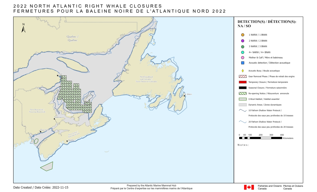

(The above maps have no legal bearing and are provided for visual reference only.)
For more information
Please visit the Interactive map on the latest right whale observations for regular updates.
Annex 1 – Gulf of St Lawrence – NARW related closures in effect
All grids are re-opening
The following grids are re-opening on November 15, 2022 at 5:00 p.m.:
- Full grid(s) GT37, GT38, GU37, GU38, GV37, GV38, GV39, GV40, GV41, GW36, GW37, GW38, GW39, GW40, GW41, GW43, GW44, GW45, GX36, GX37, GX38, GX39, GX40, GX41, GX43, GX44, GX45, GY36, GY37, GY38, GY39, GY40, GY41, GY42, GY43, GY44, GY45, GY46, GZ35, GZ36, GZ37, GZ38, GZ39, GZ40, GZ41, GZ42, GZ43, GZ44, GZ45, GZ46, HA35, HA36, HA37, HA38, HA39, HA40, HA41, HA42, HA43, HA44, HA45, HA46, HB35, HB37, HB38, HB39, HB40, HB41, HB42, HB43, HB44, HB45, HB46, HC38, HC39, HC40, HC41, HC42, HC44, HC45, HC46, HD39, HD40, HD41, HD42, HD43, HD44, HD45, HD46, HE39, HE40, HE41, HE42, HE43, HE44, HE45, HE46, HE47, HE48, HE49, HE52, HF41, HF42, HF43, HF44, HF45, HF46, HF47, HF48, HF49, HF50, HF51, HF52, HG51, HG52
- Portion of grid(s) deeper than the 20 fathom shallow water protocol line only GT36, GU36, GV36, GY35, GX35, GZ34, HA34, HB34, HB36, HC37, HC49, HC50, HC51, HD49, HD50, HD51, HD52, HE50, HE51, HF39, HF40, HG48, HG49, HG50
- Portion of grid(s) between 10 and 20 fathom shallow water protocol line: HD49, HD50, HD51, HE50, HE51
Annex 2 – Bay of Fundy – NARW related closures in effect
There are no grid closures related to NARW in the Bay of Fundy.
Annex 3 – Roseway Basin Critical Habitat – NARW related closures in effect
There are no grid closures related to NARW in the Roseway Basin Critical Habitat.
Annex 4 – Outside of the dynamic and critical habitat areas – NARW related closures in effect
There are no other grid closures related to NARW in the waters outside of the dynamic and critical habitat areas.
- Date modified: