
North Atlantic Right Whale - Notice of grid re-opening(s) HS22, HS23, HS24, HT22, HT23, HT24, HU22, HU23
October 31, 2022 – Fisheries and Oceans Canada (DFO) is providing notice of grid status updates related to the North Atlantic Right Whale (NARW). The information presented herein is consistent with the 2022 NARW management measures previously announced by DFO.
All times listed in this document are in Atlantic Daylight Time (ADT).
New updates are in effect in the following waters (refer to the corresponding annex for details):
- New grid re-opening(s) in the Bay of Fundy - Annex 2
All NARW related grid closures currently in effect in Canadian waters are provided in the following corresponding annexes:
- Annex 1 – for the Gulf of St Lawrence
- Annex 2 – for the Bay of Fundy
- Annex 3 – for the Roseway Basin Critical Habitat
- Annex 4 – for all waters outside of the dynamic or critical habitat areas
DFO asks licence holders to be vigilant during fishing activities concerning the presence of North Atlantic Right Whales. Furthermore, please be reminded that it is the responsibility of the licence holder and operator to take into account the marine safety notices issued, amongst others, by Environment and Climate Change Canada and Transport Canada, as well as the standards and best practices in marine safety, and to take all measures to ensure safe fishing operations.
Any reference to the term "Notice" in this document means this "Notice to Fish Harvesters". The Notice to Fish Harvesters, including its annexes, is provided for information purposes only. In case of discrepancy between the information in the Notice to Fish Harvester and a Variation Order, the latter will prevail.
Coordinates
| Points | Position* | |
|---|---|---|
| North Latitude (N) | West Longitude (W) | |
| 1 | 48° 50' 00.00" | 64° 10' 00.00" |
| 2 | 48° 50' 00.00" | 63° 40' 00.00" |
| 3 | 48° 30' 00.00" | 63° 40' 00.00" |
| 4 | 48° 30' 00.00" | 63° 10' 00.00" |
| 5 | 48° 00' 00.00" | 63° 10' 00.00" |
| 6 | 48° 00' 00.00" | 63° 00' 00.00" |
| 7 | 48° 20' 00.00" | 63° 00' 00.00" |
| 8 | 48° 20' 00.00" | 62° 30' 00.00" |
| 9 | 48° 00' 00.00" | 62° 30' 00.00" |
| 10 | 48° 00' 00.00" | 62° 20' 00.00" |
| 11 | 47° 20' 00.00" | 62° 20' 00.00" |
| 12 | 47° 20' 00.00" | 62° 13' 13.31" |
| 13 | 47° 17' 59.96" | 62° 15' 00.01" |
| 14 | 47° 13' 59.96" | 62° 16' 00.01" |
| 15 | 47° 10' 59.96" | 62° 18' 00.01" |
| 16 | 47° 08' 59.96" | 62° 16' 00.01" |
| 17 | 47° 04' 59.96" | 62° 00' 00.00" |
| 18 | 47° 11' 51.39" | 62° 00' 00.00" |
| 19 | 47° 10' 59.96" | 61° 48' 00.01" |
| 20 | 47° 11' 59.96" | 61° 40' 00.00" |
| 21 | 47° 20' 00.00" | 61° 33' 30.03" |
| 22 | 47° 20' 00.00" | 61° 30' 00.00" |
| 23 | 47° 00' 47.96" | 61° 30' 00.00" |
| 24 | 47° 00' 59.96" | 61° 28' 00.01" |
| 25 | 47° 10' 00.00" | 61° 23' 29.99" |
| 26 | 47° 10' 00.00" | 61° 20' 00.00" |
| 27 | 46° 40' 00.00" | 61° 20' 00.00" |
| 28 | 46° 40' 00.00" | 61° 40' 00.00" |
| 29 | 46° 30' 00.00" | 61° 40' 00.00" |
| 30 | 46° 30' 00.00" | 61° 45' 00.30" |
| 31 | 46° 32' 59.96" | 62° 10' 00.00" |
| 32 | 46° 40' 00.00" | 62° 10' 00.00" |
| 33 | 46° 40' 00.00" | 63° 22' 42.93" |
| 34 | 46° 49' 18.42" | 63° 40' 00.00" |
| 35 | 47° 10' 00.00" | 63° 40' 00.00" |
| 36 | 47° 10' 00.00" | 63° 50' 00.00" |
| 37 | 47° 20' 00.00" | 64° 00' 00.00" |
| 38 | 47° 25' 59.96" | 64° 03' 00.01" |
| 39 | 47° 20' 00.00" | 64° 10' 00.00" |
| 40 | 47° 20' 00.00" | 64° 30' 00.00" |
| 41 | 47° 28' 39.97" | 64° 30' 00.00" |
| 42 | 47° 29' 59.96" | 64° 29' 00.00" |
| 43 | 47° 44' 59.96" | 64° 20' 00.00" |
| 44 | 47° 50' 00.00" | 64° 20' 00.00" |
| 45 | 48° 00' 00.00" | 64° 10' 00.00" |
| 46 | 48° 07' 59.96" | 64° 10' 00.00" |
| 47 | 48° 08' 59.96" | 64° 20' 00.00" |
| 48 | 48° 10' 00.00" | 64° 20' 00.00" |
| 49 | 48° 10' 00.00" | 64° 10' 00.00" |
| 50 | 48° 27' 59.96" | 64° 10' 00.00" |
| 51 | 48° 27' 59.96" | 64° 09' 00.00" |
| 52 | 48° 30' 00.00" | 64° 06' 00.09" |
| 53 | 48° 31' 42.82" | 64° 10' 00.00" |
| 54 | 48° 36' 19.96" | 64° 10' 00.00" |
| 55 | 48° 36' 59.96" | 64° 06' 00.00" |
| 56 | 48° 38' 59.96" | 64° 07' 00.00" |
| 57 | 48° 38' 59.96" | 64° 10' 00.00" |
| 58 | 48° 44' 11.96" | 64° 10' 00.00" |
| 59 | 48° 40' 59.96" | 64° 06' 00.00" |
| 60 | 48° 41' 59.96" | 64° 03' 00.00" |
| 61 | 48° 48' 59.96" | 64° 10' 00.00" |
| 62 | 48° 50' 00.00" | 64° 10' 00.00" |
| Points | Position* | |
|---|---|---|
| North Latitude (N) | West Longitude (W) | |
| 1 | 47° 20' 00.00" | 63° 00' 00.00" |
| 2 | 47° 20' 00.00" | 62° 50' 00.00" |
| 3 | 47° 10' 00.00" | 62° 50' 00.00" |
| 4 | 47° 10' 00.00" | 63° 00' 00.00" |
| 5 | 47° 20' 00.00" | 63° 00' 00.00" |
* Area enclosed by rhumb lines (similar to straight lines plotted on a nautical chart) joining the points listed above in the order they are listed. Point references are based on the geodesic system North American Datum 1983 (NAD83). Positions are expressed in degrees, minutes and seconds.
(The above maps have no legal bearing and are provided for visual reference only.)
For more information
Please visit the Interactive map on the latest right whale observations for regular updates.
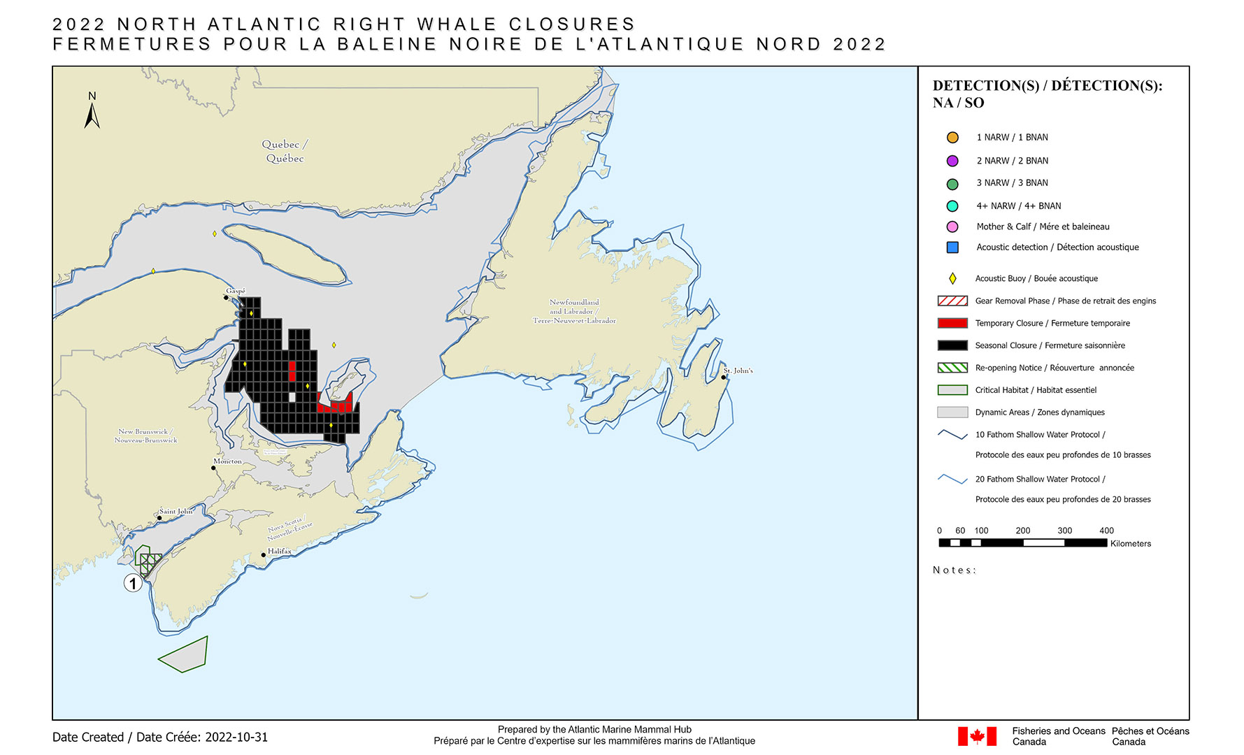
Annex 1 – Gulf of St Lawrence – NARW related closures in effect
Previously announced applicable closures
The following grid(s) remain temporarily closed until further notice in the Gulf of St Lawrence:
- Full grid(s) GZ43, HA43, HD49
- Portion of grid(s) HC47, HC49, HC50, HC51, HD47, HD48
- Portion of grid(s) between 10 and 20 fathom shallow water protocol line: HD50, HD51, HE50, HE51
The following grids are seasonally closed until November 15, 2022, in the Gulf of St Lawrence:
- Full grid(s) GT37, GT38, GU37, GU38, GV37, GV38,GV39, GV40, GV41, GW36, GW37, GW38, GW39, GW40, GW41, GW43, GW44, GW45, GX36, GX37, GX38, GX39, GX40, GX41, GX43, GX44, GX45, GY36, GY37, GY38, GY39, GY40, GY41, GY42, GY43, GY44, GY45, GY46, GZ35, GZ36, GZ37, GZ38, GZ39, GZ40, GZ41, GZ42, GZ44, GZ45, GZ46, HA35, HA36, HA37, HA38, HA39, HA40, HA41, HA42, HA44, HA45, HA46, HB35, HB37, HB38, HB39, HB40, HB41, HB42, HB43, HB44, HB45, HB46, HC38, HC39, HC40, HC41, HC42, HC44, HC45, HC46, HD39, HD40, HD41, HD42, HD43, HD44, HD45, HD46, HE39, HE40, HE41, HE42, HE43, HE44, HE45, HE46, HE47, HE48, HE49, HE52, HF41, HF42, HF43, HF44, HF45, HF46, HF47, HF48, HF49, HF50, HF51, HF52
- Portion of grid(s) GT36, GU36, GV36, GY35, GX35, GZ34, HA34, HB34, HB36, HC37, HD50, HD51, HD52, HE50, HE51, HF39, HF40, HG48, HG49, HG50
The closures are in effect for the following fisheries when the fishing seasons are open in the Gulf, Newfoundland & Labrador, and Quebec Regions: snow crab, toad crab, rock crab, lobster, whelk, Greenland halibut (fixed gear), winter flounder (fixed gear), bait (fixed gear), and herring (trap net). Closures will also be in effect for Atlantic halibut (fixed gear), mackerel (gillnet) and herring (gillnet) when gear is left unattended.
The closures are in effect for the following fisheries when the fishing seasons are open in the Maritimes Region: crab, herring (gillnet), mackerel (gillnet), groundfish (gillnet), hagfish, lobster. Closures are also in effect for groundfish (longline) when gear is left unattended.
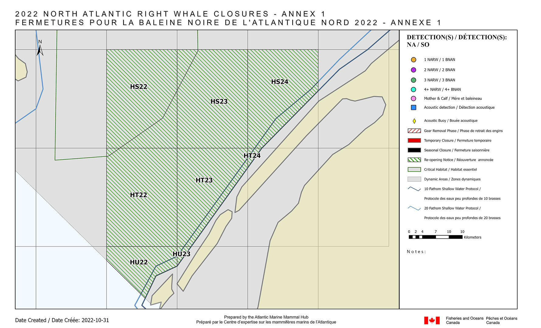
Annex 2 – Bay of Fundy – NARW related closures in effect
New re-opening information
If there are no new detections, the following grid(s) will be re-opening on October 31, 2022 at 5:00 p.m.:
- Full grid(s) HS22, HS23, HT22
- Portion of grid(s) HS24, HT23, HT24, HU22, HU23
The closures are in effect for the following fisheries when the fishing seasons are open in the Maritimes Region: crab, herring (gillnet), mackerel (gillnet), groundfish (gillnet), hagfish, lobster. Closures are also in effect for groundfish (longline) when gear is left unattended.
Annex 3 – Roseway Basin Critical Habitat – NARW related closures in effect
There are no grid closures related to NARW in the Roseway Basin Critical Habitat.
Annex 4 – Outside of the dynamic and critical habitat areas – NARW related closures in effect
There are no other grid closures related to NARW in the waters outside of the dynamic and critical habitat areas.
- Date modified: