
Musquash Estuary Marine Protected Area (MPA)
Note:
Charts, diagrams and contact information on this website are provided for information purposes only and should not be used for fishing, navigation or other purposes. Please refer to the MPA Regulations or contact your regional Fisheries and Oceans Canada office for official coordinates.
On this page
- At-a-glance
- Ecosystem
- Management and conservation
- Activity application
- Public access points
- Publications
At-a-glance

Map: Musquash Estuary Marine Protected Area
Dataset for all MPAs available.

Video: Musquash Estuary - A Protected Treasure
Location
Bay of Fundy, New Brunswick; Scotian Shelf Bioregion
Size (km2) contribution to Marine Conservation Targets
About 7 km2
% coverage contribution to Marine Conservation Targets
About 0.01%
Date of designation
December 2006
Conservation objectives
- Maintain productivity of harvested species
- Maintain biodiversity of individual species, communities and populations within the different ecotypes
- Safeguard habitat, including the physical and chemical properties of the ecosystem, by maintaining water and sediment quality
Prohibitions
The Musquash Estuary MPA Regulations prohibit activities that disturb, damage, destroy or remove from this Area living marine organisms or any part of their habitat, unless listed as exceptions in the Regulations or approved by the Minister.
Environmental context
Musquash Estuary Marine Protected Area (MPA) is located 20 km southwest of Saint John, New Brunswick. Its boundary is defined by the water level at low tide. Musquash is unique among Bay of Fundy estuaries due to its size, expansive salt marshes and natural condition. It is the largest, ecologically-intact estuary in the Bay of Fundy. This productive habitat is home to many birds, mammals, fish, invertebrates and marine plants.
Estuaries are often surrounded by low-lying coastal grasslands, called salt marshes, which are frequently covered by the tide. These salt marshes perform a variety of functions:
- they filter sediment and pollutants
- buffer coastal lands from storm surges and floods
- prevent erosion
- stabilize shorelines
In the Bay of Fundy, more than 85% of the original salt marshes have been altered by humans over the past 300 years.
Ecosystem

Musquash Estuary MPA
An estuary is a partially-enclosed body of coastal water into which freshwater flows from rivers and streams, mixing with the saltwater from the ocean. Estuaries are considered one of the Earth's most productive ecosystems, hosting several habitat types that support a diverse range of wildlife. They are often surrounded by low-lying coastal grasslands, called salt marshes, which are frequently covered by the tide.
Musquash is unique among Bay of Fundy estuaries due to its size, expansive salt marshes and natural condition. It is the largest, ecologically-intact estuary in the Bay of Fundy and exhibits an abundance of wildlife and commercial fisheries. The estuary's location, shape and oceanographic characteristics support diverse habitat and high marine biological productivity.
Fisheries and Oceans Canada is committed to conserving and protecting the Musquash Estuary MPA and intertidal area and the species that thrive there. It is aided in its efforts by owners and managers of the surrounding land, including:
- Ducks Unlimited Canada
- Eastern Habitat Joint Venture
- Nature Conservancy of Canada
- Province of New Brunswick
- Government of Canada
The Conservation Council of New Brunswick, through its advocacy work, also contributes to the conservation and protection of the Musquash Estuary ecosystem.
Management and conservation
Conservation and protection of the ecosystem is the primary goal of management and specific conservation objectives have been established.
The Musquash Estuary encompasses unique habitats, and areas of high biological diversity and biological productivity, and is an area of importance for a variety of commercial and non-commercial fisheries. These characteristics provide the foundation for conservation and protection objectives for the MPA.
The conservation objectives are to ensure no unacceptable reduction or human-caused modification in:
- productivity, so that harvested species remain healthy and abundant
- biodiversity, so that the diversity of individual species, communities, and populations within the different ecotypes are maintained
- habitat, to safeguard the physical and chemical properties of the ecosystem by maintaining water and sediment quality
The conservation objectives will be achieved by addressing management priorities and through the implementation of management actions outlined in the management plan.
The Musquash Estuary MPA Management Plan (PDF, 474 KB) guides management of the MPA and Administered Intertidal Area. The management plan provides details on:
- the purpose and scope
- the legislative authority in the Musquash Estuary, the transfer of administration and control of lands to the Government of Canada from the Province of New Brunswick and the federal authority to manage the estuary
- the background to the designation as an MPA
- the management vision, guiding principles, conservation objectives and management priorities
- the Musquash Estuary MPA Regulations and approach for managing activities within the administered intertidal area under the Fisheries Act
- the governance structure
The Musquash Estuary MPA Advisory Committee (MAC) was formally established in 2007 to advise DFO on the protection and management of the Musquash MPA. The MAC helped with the development of the management plan and facilitates dialogue between DFO and MPA rights holders and stakeholders concerning management plan implementation. MAC members represent:
- government
- non-government organizations
- industry
- First Nations
- community groups with an interest in the MPA
They provide skills, knowledge, and experience related to the ecology, management, conservation and general use of the MPA.
Evaluation and reporting: A review of Musquash Estuary MPA management (PDF, 474 KB, 2015) was recently conducted to measure DFO's progress towards meeting the commitments laid out in the Musquash Estuary MPA management plan and other Oceans Act MPA program guidance and policies. The findings are being used to inform the review and revision of the Musquash Estuary MPA Management Plan.
Progress report: A Progress Report (PDF, 1.3 MB, 2015) is available that provides the management and research highlights since designation.
For more information on the Musquash Estuary Marine Protected Area management regulations please review the Musquash Estuary Marine Protected Area Regulations and Regulatory Impact Analysis Statement (PDF, 2.6 MB, 2006).
Activity application for Musquash Estuary MPA
Scientific, educational, archaeological, commercial tourism and habitat restoration activities are allowed in the Musquash Estuary MPA if a proponent submits an activity plan to the Department of Fisheries and Oceans (DFO) for Ministerial approval.
Learn more about the activity plan process
Public access points
The Musquash Estuary is open to the public to enjoy, but remember:
- weather, wind, waves and tides can rapidly change
- shorelines can be slippery
- old marine vessels and structures may be unsteady
- shoals, debris, fishing equipment and navigational aids may be hidden at high tide
All Musquash Estuary access points can be reached from the Trans Canada Highway 1. Coming from Saint John, New Brunswick, follow the Trans Canada Highway 1 West. Coming from St. Stephen or St. Andrews, New Brunswick, follow the Trans Canada Highway 1 East. See this map for the location of areas described below.
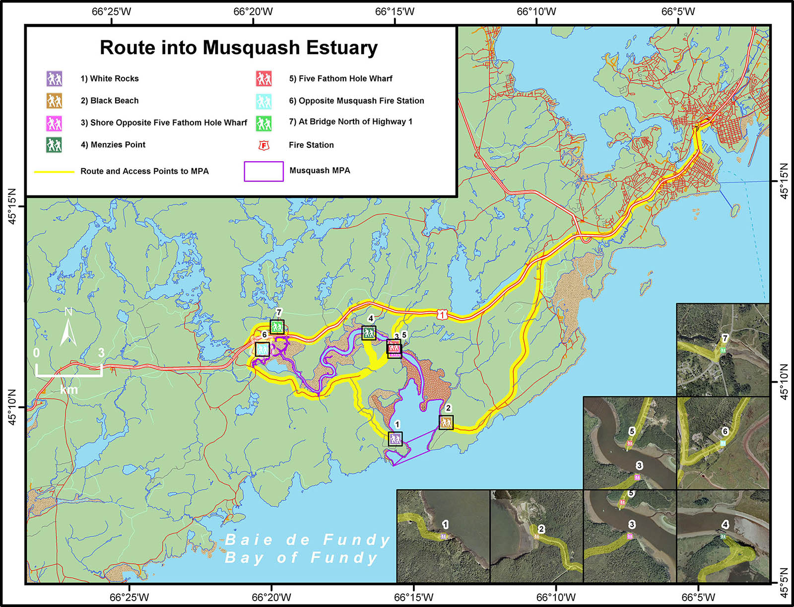
Route into Musquash Estuary
Note:
Fisheries and Oceans Canada does not maintain these public access points. Some of these routes may not be drivable. Use them at your own risk.
1. Black Beach
Getting there
- take exit 112 (Coleson Cove) from Trans Canada Hwy 1
- travel south on King William Road
- continue past the Coleson Cove Generating Station (on left) to the end
- there's a steep hill to the beach
Activities
- launch a canoe/kayak (no trailer boat launch)
- access Musquash Head Lighthouse hiking trail
2. Five Fathom Hole Wharf
Getting there
- take exit 103 (Prince of Wales) from Trans Canada Hwy 1
- travel south to stop sign
- turn left and follow road south past sharp bend
- the wharf is just ahead down the hill
Activities
- boating (using trailer boat launch) or canoe/kayak
- access Butler's Creek hiking trail
3. White Rocks
Getting there
- take exit 96 (Chance Harbour/Musquash) from Trans Canada Hwy 1
- travel south on Musquash Road, stay right to old church
- turn right on Gooseberry Cove Road and continue to end
Activities
- launch a canoe/kayak (no trailer boat launch)
4. Menzies Point
Getting there
- take exit 96 (Chance Harbour/Musquash) from Trans Canada Hwy 1
- travel south on Musquash Road, staying right to old church
- beyond the church, the road is impassable by vehicle
- veer left when road divides
- hiking access only
Activities
- following a portage, may be able to launch canoe/kayak (no trailer boat launch)
5. Shoreline Opposite Five Fathom Hole Wharf
Getting there
- take exit 96 (Chance Harbour/Musquash) from Trans Canada Hwy 1
- travel south on Musquash Road, staying right to old church
- beyond the church, the road is impassable by vehicle
- continue straight when road divides
- hiking access only
Activities
- following a portage, may be able to launch canoe/kayak (no trailer boat launch)
6. Opposite Musquash Fire Hall
Getting there
- getting there: Take exit 96 (Chance Harbour/Musquash) from Trans Canada Hwy 1
- travel south on Musquash Road. At stop sign, turn left on Malcolm Meehan Road
- walk from the fire hall (on left) to access point
- Hiking access only
Activities
- following a portage, may be able to launch canoe/kayak (no boat launch)
7. At Bridge North of Hwy 1
Getting there
- getting there: Take exit 96 (Chance Harbour/Musquash) from Trans Canada Hwy 1
- travel north on Musquash Road
- turn left at power station, then right onto Shipyard Road
- continue to end
Activities
- at high tide, can launch canoe/kayak (no boat launch)
Contact us
Musquash Estuary Marine Protected AreaFisheries and Oceans Canada
Tel: (902) 426-9919
Fax: (902) 426-2331
Email: Musquash@dfo-mpo.gc.ca
Publications
- Musquash Estuary Marine Protected Area (MPA) annual report 2023
- View 7 days Tidal Predictions for the tide times and heights in this area
- Awareness brochure (PDF, 491 KB, 2009)
- Date modified: