
Center of Expertise in Marine Mammology: Scientific Research Report 2012-2014
Table of Contents
- Acknowledgements
- Message from the Director of CEMAM
- The 2013 High Arctic Cetacean Survey
- St. Lawrence Estuary Beluga
- Predator-borne Acoustic Transceivers and GPS Tracking Reveal Encounters with Acoustically Tagged Free-ranging Marine Fish
- Long-term Measures of Reproductive Performance Reveal Marked Variation in Fitness in Grey Seals
- Year-round Atlas of Shipping Noise: The PSSEL Model
- Climate Related Changes in the Quality and Availability of Land Fast Sea Ice Suitable for Breeding Ringed Seals Along the Coast of Labrador
- Belugas and Ringed Seals: Indicators of Ecosystem Change in the Beaufort Sea
- The Impact of Climate Change on Reproduction in an Ice-dependent Species, the Northwest Atlantic Harp Seal
- Publications 2012-2014
The 2013 High Arctic Cetacean Survey

Figure 1. The team of the 2013 High Arctic Cetacean Survey and one of the survey aircrafts (photo: P. Carter).

Figure 2. An example of the high-definition photographs taken by a belly-mounted camera in a Twin Otter flying at 1,000 feet. Inset is of zoomed-in-view of narwhals observed in Tremblay Sound (photo: DFO).
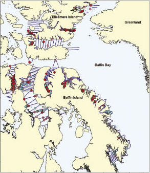
Figure 3. Map of survey effort (blue lines), narwhal sightings (red circles) and bowhead sightings (blue circles).
Thomas Doniol-Valcroze, Steve Ferguson, Jean-François Gosselin, Jack Lawson and Kevin Hedges
Numerous Inuit communities across the Canadian Arctic hunt narwhals and bowhead whales for subsistence, economic and cultural reasons. Sustainability of these important harvesting activities relies on obtaining up-to-date estimates of population abundance. Obtaining such estimates, however, is challenging because of the vast geographic areas to cover, and difficult Arctic weather conditions. Moreover, narwhals exhibit site fidelity by returning to the same summering areas every year, and therefore each of these summer stocks has to be surveyed to provide estimates that are meaningful to local hunters.
The purpose of the High Arctic Cetacean survey, a large-scale aerial survey conducted in the eastern Canadian Arctic in August 2013, was to obtain new abundance estimates of the Baffin Bay narwhal population and the Eastern Canada-West Greenland bowhead whale population. The last estimates were approximately 10 years old and known to be incomplete, given the broad spatial range of both populations. Never before had a survey counted all of the Canadian Baffin Bay narwhal stocks during one summer. We also wanted to obtain for the first time an estimate for the putative narwhal stocks found in the waters around Ellesmere Island.
The only way to achieve these ambitious goals within a short time window constrained by ice cover, weather conditions and whale migrations was to use three aircraft simultaneously, each with a full team of experienced observers and equipment operators. To make this possible, it was necessary to combine the resources of three regions of the Department of Fisheries and Oceans: Central & Arctic, Quebec, and Newfoundland & Labrador. Marine mammal specialists from all three regions were involved in every step of the project, from logistics and survey design to manning the planes and analyzing the data. In all, fifteen team members gathered at the Polar Continental Shelf Program base in Resolute on August 1st and began preparing the three aircraft for the survey (Figure 1). During the first two days, all observers were given extensive training sessions to familiarize themselves with the data collection protocols and included practice flights around Resolute.
Nunavut communities were involved at every step of the survey process. A visit was made to Grise Fiord in 2012 to collect local information on narwhal movements and distribution around Ellesmere Island, and four community members participated in a reconnaissance survey of the identified areas. Traditional knowledge on narwhal and bowhead whales all around Baffin Island was used in conjunction with previous aerial surveys and satellite telemetry studies to design the flight plans and determine the best order and timing of the different spatial components of the survey. During the survey, each of the plane crews included one Inuk as part of the four observers collecting sightings of whales. Moreover, members of the Hunter and Trapper Organizations in each community visited by the survey aircraft (Resolute Bay, Arctic Bay, Pond Inlet, Clyde River, Kugaaruk, Taloyoak, Hall Beach and Pangnirtung) took advantage of the opportunity to fly on the planes during surveys around their communities.
The aerial survey was flown at an altitude of 1,000 feet using three deHavilland Twin Otter 300 aircraft, each equipped with four bubble windows and a large belly window. Four observers were stationed at the windows, with a fifth team member acting as a navigator and camera operator. Sighting data were collected by two observers on each side to increase the probability of detecting narwhals and to improve precision of the survey results. In addition to visual observations, the three aircraft collected continuous photographic images using two digital cameras pointing downwards towards either side of the survey track line, taking pictures through the belly window (Figure 2). These geo-referenced images will be used to generate separate abundance estimates and will provide another means to estimate the proportion of whales missed by observers.
Between August 1 and August 26, the three teams flew for a combined total of 241 hours and surveyed the majority of the planned areas, covering the entire summering range of Baffin Bay narwhal stocks and most of the bowhead whale range (Figure 3), despite a late ice break-up and difficult weather conditions throughout the month. The flying sequence was designed to survey areas in order of priority while taking into consideration local knowledge of ice conditions. In an effort to avoid the effect of potential movements of whales between areas, we tried to survey each stratum in a day or two. For large or remote areas, this often required the use of two, sometimes all three aircraft simultaneously. Overall, the survey was extremely successful and represents DFO’s largest scale assessment of cetacean populations in the Arctic.
Processing of the survey data, which began in fall of 2013, involved transcribing, assembling and verifying the recordings made by the observers, mapping observations, assessing duplicate sightings and running statistical programs designed to best estimate narwhal and bowhead abundance. Additional analyses have been undertaken to improve the accuracy of the stock assessments, including re-analysing dive times from telemetry data to be able to correct estimates for whales that were submerged at the time the aircraft flew over and therefore could not be counted. The analysis of the visual survey data was presented at the annual meeting of the national marine mammal peer-review committee in the fall of 2014 and will yield new and updated abundance estimates of the five Canadian stocks of the Baffin Bay narwhal population and the Eastern Arctic-West Greenland bowhead whale population. The reading and analyzing of the 180,000 high-definition photographs is also underway and will take several more months to complete.
The abundance estimates for each narwhal stock and for the bowhead population will allow managers and stakeholders to determine how many whales can be hunted sustainably while decreasing the risk of local depletion of resources in each community.
- Date modified: