
Geoduck clam (Panopea generosa)
On this page
- Species overview
- Fishery history
- Ecosystem context
- Science advice and research
- Integrated Fisheries Management Plan
- Related links
Species overview
Physical description
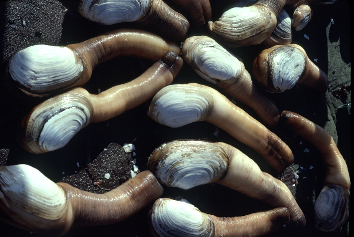
Geoduck Clam is the largest burrowing clam in the world. It is a bivalve, meaning it has 2 shells. Its shells are white and rectangular. Its siphon is too large to be confined by its shells. Its siphon is white to brown in colour.
Geoduck Clam grows quickly for the first 10 to 15 years of life. Its shells can grow over 20 centimetres (cm) long. After that, its shells typically don’t increase much in length and thicken instead. This increases body weight. It can weigh up to 3 kilograms (kg) however the average clam is about 1 kg.
Geoduck Clam can live for over 180 years. It is one of the longest-lived animals in the world.
Distribution
Geoduck Clam is found from Alaska to Mexico. It lives in the low intertidal zone down to at least 110 metres (m) deep. It burrows into softer substrates up to 1 m deep.
Life cycle
Geoduck Clam spawns from May to July as waters warm. It is a broadcast spawner, meaning males and females release eggs and sperm into the water for fertilization. Females can release 7 to 10 million eggs. Mature sex organs are found in Geoducks from 2 to 107 years old. This means individuals may be able to reproduce for over a century.
Geoduck larvae are pelagic for 40 to 50 days, floating freely in deep waters, before settling on the sea bed and burrowing into the substrate up to one meter in depth.
Fishery history
The word Geoduck originated from the Coast Salish First Nations word for “dig deep”. Geoduck Clam may be harvested for Indigenous food, social, and ceremonial (FSC) purposes coastwide subject to biotoxin testing. There is also a recreational fishery. FSC and recreational fishing are open year-round except for time and area closures due to biotoxin contamination. FSC and recreational fishing effort are low because it is difficult to access these deepwater clams.
The commercial Geoduck fishery is one of the most profitable fisheries in BC and began in 1976. In 1979, licences were limited and quotas were introduced. Coastwide landings peaked in 1987 at 5735 tonnes. In 1989, additional management measures were introduced to support sustainable harvest. Most landings have come from the north coast since 1995. The commercial total allowable catch (TAC) had remained relatively constant for many years until 2012, when it was reduced following improved stock assessments and harvest advice. In more recent years, the TAC has been adjusted to reflect changes in estimated biomass associated with Sea Otter predation and changes in spatial management measures.
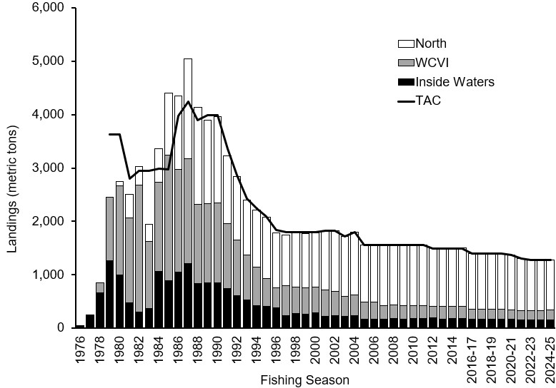
Figure Caption: Total landings of Geoduck measured in metric tons since 1976. Shaded bars are used to denote different fishing areas: the north coast, the west coast of Vancouver Island (WCVI), and inside waters. The black line represents annual Total Allowable Catch (TAC).
The fishery is managed by:
- TAC
- individual vessel quotas
- scheduled area openings
- sub-bed area quotas
- catch verification program
On the west coast of Vancouver Island, Geoduck harvest areas are open every year. This annual schedule provides great flexibility due for harvesting and helps address the impacts of Sea Otter predation on Geoduck populations. The north coast and inside waters regions are each divided into 3 sub-units. Each sub-unit is fished, for the most part, once every 3 years. This rotational fishery approach is largely for logistics and makes managing and monitoring the fishery easier.
The commercial fishery is open year-round, but can be closed or re-opened based on:
- biotoxin contamination
- market demand
- quota completion
Geoduck Clam is hand-picked by commercial divers using surface-supply air gear. Live clams are removed from the sea bed using a hand-held water jet known as a stinger. Commercial gear cannot be used by recreational harvesters. Divers harvest clams between 3 and 20 m deep. Horse Clam is harvested incidentally to Geoduck Clam and not typically targeted. However, there is a small directed Horse Clam fishery that is managed under a TAC in the southern waters.
The majority of Geoduck Clam harvested in Canada is exported. Live clams are shipped to processing plants where they are packed and delivered live to Asian markets.
Geoduck aquaculture has occurred on a small scale since the early 1990s.
Ecosystem context
Many Geoduck Clams live in natural refugia, meaning they are outside of the harvestable area. This protects a portion of the breeding pool from exploitation. Geoduck refugia include:
- shallower than 3 m deep where divers are not allowed to harvest them
- below 20 m deep where divers cannot reach them
in gravel or shell-packed beds that are difficult for divers to extract them from in closed areas, for example:
- protected eel grass beds
- contaminated areas
- marine parks and marine protected areas
- areas designated for research
Geoduck Clam is eaten by Sea Otters. Large numbers of Sea Otters impact Geoduck populations and harvest. Geoduck beds are not harvested in some areas due to the impacts of Sea Otter predation on stocks.
Geoduck Clams can retain biotoxins, such as Paralytic Shellfish Poison (PSP). Because of this, the fishery may be closed to reduce risks to human health.
Science advice and research
Science advice and research for Geoduck
Integrated Fisheries Management Plan
Integrated Fisheries Management Plan for Geoduck and Horse Clam
Related links
- Date modified: