
Conditional Management Plan summary for Stratford, Prince Edward Island
This document provides a description of the shellfish growing area that is managed under a Conditional Management Plan (CMP) for Stratford (PE). It also describes the detection, notification and response (DNR) times needed for parties to fulfill their CMP roles when sewage is discharged from the Wastewater Treatment Plant (WWTP) system.
Detection, notification and response
The time taken for a sewage discharge to be detected, and for stakeholders and authorities to receive notification of the discharge is:
- within 1 hour
The time taken for federal authorities to respond to the sewage discharge by officially closing an affected shellfish area is:
- within 1 business day of receiving notification
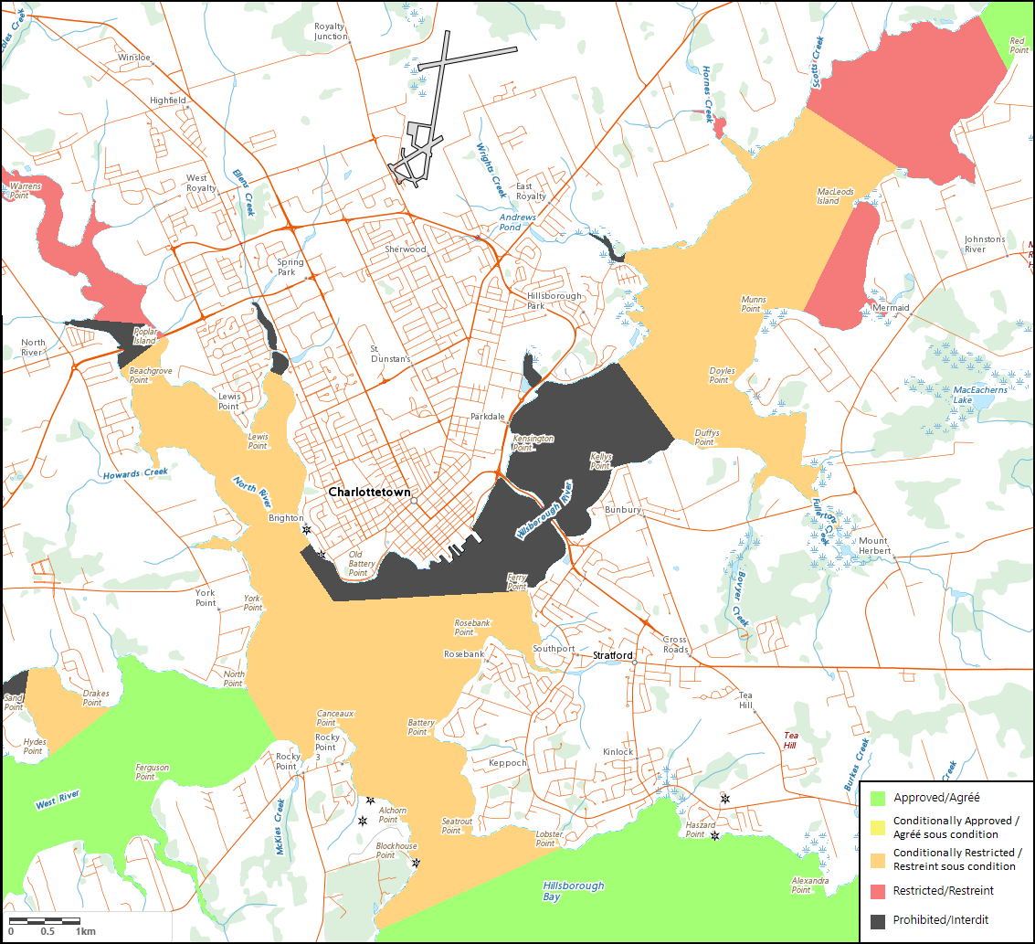
Area classification description
Shellfish harvest areas near the WWTP are divided into zones based on how intermittent sewage discharge from the WWTP will impact the sanitary quality of the water. Harvesting activities in these zones are classified as either:
- prohibited
- restricted
- conditionally restricted
- conditionally approved
The current classification of Charlottetown Harbour is described as follows:
Conditionally restricted
The conditionally-managed waters of the Charlottetown Harbour estuary are classified as conditionally-restricted and lie within the following boundaries:
The waters of North River downstream of a line south of the Trans-Canada Highway causeway between 46.25891 N, 63.17766 W and 46.2592 N, 63.17658 W.
The waters of Charlottetown Harbour at the confluence of the North and West Rivers; inside of a line across the mouth of West River between 46.21314 N, 63.16119 W at North Point and 46.2067 N, 63.15549 W near Canceaux Cove, and inside of a line across the harbour mouth between 46.18211 N, 63.13602 W near Holland Cove and 46.19268 N, 63.10212 W at Lobster Point.
The waters of Hillsborough (East) River downstream of a line between 46.28898 N, 63.05616 W and 46.28115 N, 63.03879 W, excluding the waters of Mermaid Cove inside of a line between 46.30082 N, 63.05671 W near MacLeod’s Island and a point at 46.27576 N, 63.04722 W.
The conditionally-managed area described above excludes prohibited areas in: Ellen’s Creek in West Royalty; the Victoria Park seawall and Charlottetown harbour front; upstream of, and the vicinity of, the Hillsborough River bridge; and Wright’s Creek in East Royalty.
Please note that the coordinates described above reference the WGS84 geodetic datum.
Shellfish growing area classification map
- Date modified: