
Conditional Management Plan summary for Parksville and Qualicum Beach, British Columbia
This document provides a description of the shellfish growing area that is managed under a Conditional Management Plan (CMP) for Parksville and Qualicum Beach (BC). It also describes the detection, notification and response (DNR) times needed for parties to fulfill their CMP roles when sewage is discharged from the Wastewater Treatment Plant (WWTP) system.
Detection, notification and response
The time taken for a sewage discharge to be detected, and for stakeholders and authorities to receive notification of the discharge is:
- within 2.75 hours
The time taken for federal authorities to respond to the sewage discharge by officially closing an affected shellfish area is:
- within 1 business day of receiving notification
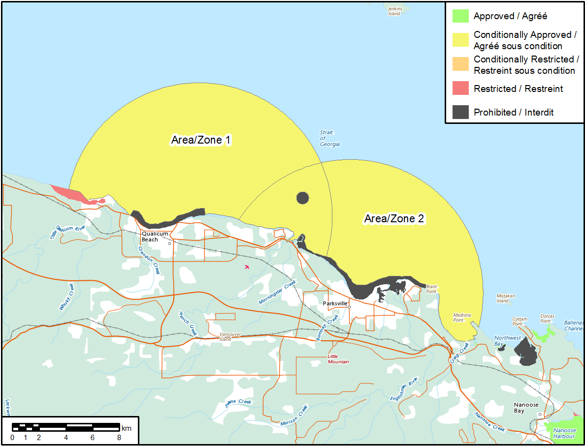
Area classification description
Shellfish harvest areas near the WWTP are divided into zones based on how intermittent sewage discharge from the WWTP will impact the sanitary quality of the water. Harvesting activities in these zones are classified as either:
- prohibited
- restricted
- conditionally restricted
- conditionally approved.
The current classification of the Parksville and Qualicum Beach Shellfish Growing Area subsectors are described as follows:
Area 1 – Emergency sanitary closure 14.hh: Hall Road, town of Qualicum Beach:
Conditionally approved
The waters and intertidal foreshore inside a circular arc with a radius of 6500 m, and excluding the areas already included in annual closures, 14.10, 14.16 and 14.31 centered at a point on land at 49.36528 N, 124.43028 W, which intersects the shoreline at 49.36778 N, 124.5225 W, and again at 49.34528 N, 124.34528 W near Hall Road in the Town of Qualicum Beach.
Area 2 – Emergency sanitary closure 14.ii: Bay Avenue, City of Parksville
Conditionally approved
The waters and intertidal foreshore inside a circular arc with a radius of 6500 m, and excluding the area already included in annual closure 14.10, centered at a point on land at 49.33167 N, 124.32806 W, which intersects the shoreline at 49.36278 N, 124.40778 W, and again at 49.31778 N, 124.23889 W near Bay Avenue in the City of Parksville.
Please note that the coordinates described above reference the WGS84 geodetic datum.
Shellfish growing area classification map
- Date modified: