
Conditional Management Plan summary for Ladysmith, British Columbia
This document provides a description of the shellfish growing area that is managed under a Conditional Management Plan (CMP) for Ladysmith (BC). It also describes the detection, notification and response (DNR) times needed for parties to fulfill their CMP roles when sewage is discharged from the Wastewater Treatment Plant (WWTP) system.
Detection, notification and response
The time taken for a sewage discharge to be detected, and for stakeholders and authorities to receive notification of the discharge is:
- within 0.25 hours (normal working hours); 4 hours (after normal working hours)
The time taken for federal authorities to respond to the sewage discharge by officially closing an affected shellfish area is:
- within 1 business day of receiving notification
Area classification description
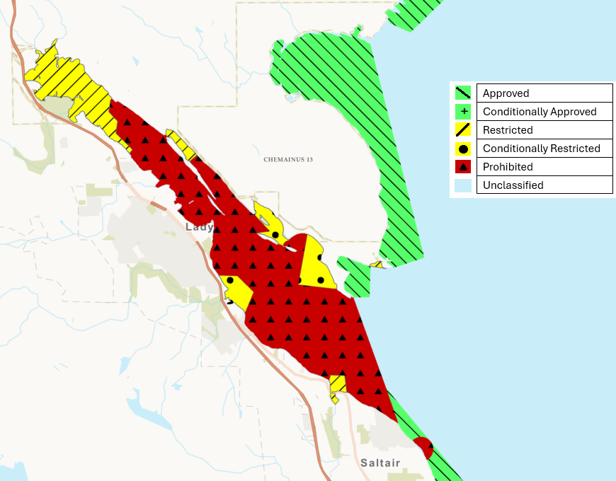
Shellfish harvest areas near the WWTP are divided into zones based on how intermittent sewage discharge from the WWTP will impact the sanitary quality of the water. Harvesting activities in these zones are classified as either:
- prohibited
- restricted
- conditionally restricted
- conditionally approved
The current classification of the Ladysmith Shellfish Growing Area subsector is described as follows:
Conditionally restricted
That portion of Ladysmith Harbour inside a line that starts at an unnamed point of land at 48°58.97’ north latitude and 123°46.37’ west longitude northwest of Sharpe Point, thence westerly to a point in water at 48°59.02’ north latitude and 123°47.03’ west longitude, thence northerly to a point on land in Sibell Bay at 48°59.57’ north latitude and 123°46.88’ west longitude, thence following the shoreline along the high water mark to the point of commencement.
And:
That portion of Ladysmith Harbour inside a line that starts at a point of land at Hunter Point at 48°59.51’ north latitude and 123°47.18’ west longitude, thence southwesterly to a point on land on the islet off the westernmost end of the easternmost Dunsmuir Island at 48°59.45’ north latitude and 123°47.28’ west longitude, thence following the northern shoreline high water mark of the westernmost Dunsmuir Island to the westernmost point at 48°59.59’ north latitude and 123°47.73’ west longitude, thence easterly to a point in water at 48°59.61’ north latitude and 123°47.51’ west longitude, thence northerly to an unnamed point of land at 48°59.80’ north latitude and 123°47.78’ west longitude, thence following the shoreline along the high water mark to the point of commencement.
And:
That portion of Ladysmith Harbour inside a line that starts at a point of land at 48°58.71’ north latitude and 123°47.92’ west longitude, thence northerly to a point in water at 48°58.94’ north latitude and 123°47.77’ west longitude, thence northwesterly to a point in water at 48°59.12’ north latitude and 123°48.04’ west longitude thence westerly to a point on land at 48°59.13’ north latitude and 123°48.38’ west longitude, thence following the shoreline along the high water mark to the point of commencement.
Please note that the coordinates described above reference the North American Datum of 1983 [NAD83].
Shellfish growing area classification map
- Date modified: