
2026 Transport Canada restricted area activated to protect North Atlantic right whales in Canada
Transport Canada speed and navigation restriction zones(GPX, 13.4 KB)
How to use GPX files
To learn more, visit our GPX Guide.
Transport Canada (TC) – June 15, 2026 – This notice to fish harvesters is issued in accordance with the 2026 Transport Canada restricted area, to protect North Atlantic right whales in Canada. This notice is to alert fish harvesters that this restricted area is activated via Navigational Warning on June 15, 2026, at 0400 UTC. See below for information on the restricted area.
Note: Vessels must follow Navigational Warnings outlining the speed restrictions. The Interim Order for the Protection of North Atlantic Right Whales (Eubalaena Glacialis) in the Gulf of St. Lawrence, 2026, enables the issuance of Navigational Warnings (NAVWARNs) imposing speed restrictions and navigation restrictions.
Speed restriction zones are described in monthly Notices to Mariners (NOTMARs), which are published by the Canadian Coast Guard. The status of these zones is broadcasted through NAVWARNs, which are published by the Coast Guard’s Marine Communications and Traffic Services Centres.
Please check the latest NAVWARN for all speed restrictions currently in effect.
Restricted area
In the summer months, an important proportion of the total North Atlantic right whale population gathers for feeding and surface activity near the Shediac Valley. Since this makes the North Atlantic right whale more susceptible to vessel collisions, a mandatory restricted area will be implemented in and near the Shediac Valley and will come into force once 80% of the restricted area is closed to fishing for the season as per the Department of Fisheries and Oceans’ (DFO) right whale closure protocol, or at the latest on June 15, 2026. The restricted area will be lifted on September 25, 2026, unless North Atlantic right whale detections are reported in high number, which would extend the restricted area beyond September 25.
The size and location of the area are determined based on historical detection data of North Atlantic right whales. All necessary details can be found in theInterim Order for the Protection of North Atlantic Right Whales (Eubalaena Glacialis) in the Gulf of St. Lawrence, 2026. Triggering and lifting of the restricted area will be communicated to mariners through NAVWARNs and notices to fish harvesters.
Vessels above 13.0 m in length (LOA) will be required to:
- avoid the area unless they are part of the exceptions listed in the Interim Order for the Protection of North Atlantic Right Whales (Eubalaena Glacialis) in the Gulf of St. Lawrence, 2026;
- transit the area at a speed not exceeding 8.0 knots over the ground if they are part of the exceptions.
The following exceptions will apply to the restricted area. The following listed vessels can travel through the area at not more than 8.0 knots over the ground:
- vessel being used for commercial fishing
- vessel being used for fishing under the authority of a licence issued under the Aboriginal Communal Fishing Licences Regulations
- vessel being used for research purposes on behalf of the Government of Canada
- vessel involved in research relating to right whales as part of a project that has received funding from the Government of Canada
- vessel being used as part of the Department of Fisheries and Oceans’ Marine Mammal Response Program to assist a marine mammal or sea turtle in distress or to access or retrieve a deceased marine mammal or sea turtle
- vessel authorized by the Government of Canada to retrieve or identify the location of abandoned or lost fishing gear;
- vessel involved in pollution response operations
- vessel avoiding immediate or unforeseen danger
- vessel being used to conduct the maintenance or repair of underwater communication cables
The following vessels can travel through the restricted area at a speed over 8.0 knots, but below 10.0 knots over the ground as required by the static speed restriction zone:
- A vessel being used by an employee of the Government of Canada or peace officer who is performing their duties.
Please refer to Schedule 1 for the coordinates of the restricted area.
Report of death or injury
In the event that at least one North Atlantic right whale is reported dead or injured in the Gulf of St. Lawrence in a zone or area where there is no NAVWARN in effect, a speed restriction of 10.0 knots over the ground for vessels above 13.0 m in length overall (LOA) will be implemented in the concerned zone(s) or area(s) for 15 days from the time the NAVWARN comes into effect.
Inclement weather exception
Mariners will be notified in advance via a NAVWARN should the speed restriction status change in any zone or area, due to inclement weather.
Within any zone or area that is no longer subject to a speed restriction due to adverse weather conditions, mariners may proceed at a safe operational speed, but are encouraged to take into consideration the potential for their vessel striking North Atlantic right whales when determining that speed during navigation.
*Non-excepted vessels are still prohibited from transiting through the restricted area.
Map of the Gulf of St. Lawrence
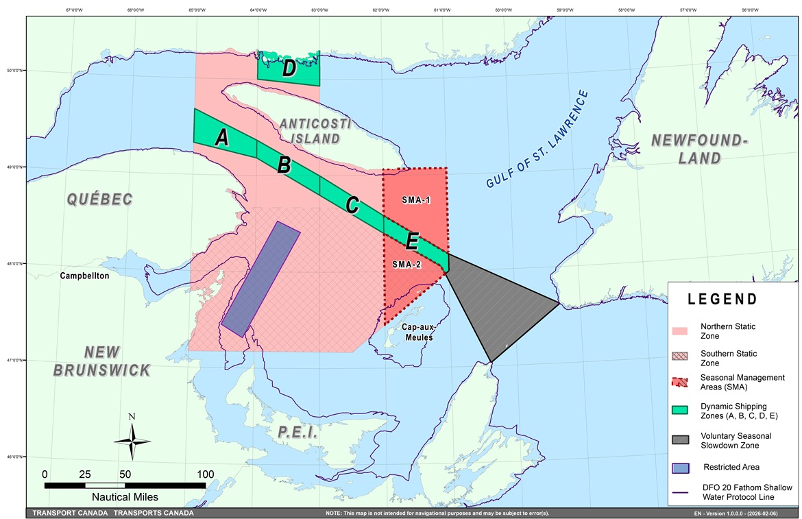
The map below provides a visual representation of the main zones mentioned. It must not be used for navigation or law enforcement purposes.
- Static zones (north and south), in pink
- Dynamic shipping zones (A, B, C, D and E), in green
- Seasonal management areas, in dark pink
- Voluntary seasonal slowdown zone, in grey
- Restricted area, in dark blue
- 36.57 m (20 fathom) DFO shallow water protocol line
Image gallery
Map of the Gulf of St. Lawrence
Long description
Map of the Gulf of St. Lawrence showing Transport Canada’s maritime traffic management zones to protect the North Atlantic right whales. On the map, we can see the northern and southern static zones, the dynamic shipping zones A, B, C, D, and E, the seasonal management areas 1 and 2, the restricted area in and near the Shediac Valley, as well as the voluntary seasonal slowdown in Cabot Strait, which is in place in the spring and the fall.
NAVWARN broadcasts
The Canadian Coast Guard’s Marine Communications and Traffic Services Centres (MCTS) issue NAVWARNs:
- By radio broadcast: for marine radio, Continuous Marine Broadcast frequencies and scheduled broadcast times, information may be found in the Radio Aids to Marine Navigation publication; and
- Online: at Canada’s Maritime Information Portal and its Navigational Warnings site, using the North Atlantic Right Whale search term or category.
Mariners must ensure they have accurate and up-to-date information about the protection of the North Atlantic right whale, as in all applicable NOTMARs and NAVWARNs.
Outbound vessels
- at Calling-in-Point 10 (St-Laurent); or
- upon a departure downstream from the Quebec pilot station (including the Saguenay River, Chaleur Bay, Miramichi Bay, etc.)
Inbound vessels
- when a clearance to enter Canadian waters is granted
Vessels in transit
- at the last reporting point prior to entering the mandatory speed restriction zones;
- vessels in transit will confirm they have received NAVWARNs.
MCTS Centres will broadcast NAVWARNs continuously throughout the season on Continuous Marine Broadcast.
It should be noted that, contrary to previous years’ operations, reminders sent to vessels in transit 10 nautical miles before entering a speed restriction zone will no longer be transmitted.
Vessel operators are required to monitor broadcasts by the Canadian Coast Guard’s Marine Communications and Traffic Services network for the most up to date information.
Aids to navigation
The Canadian Coast Guard broadcasts virtual Automatic Identification System (AIS) aids to navigation (AIS AtoN) in specific areas. These aids may notify mariners of dynamic shipping zones and/or seasonal management areas subject to speed restrictions.
Each zone is delimited by four to six virtual AIS AtoN, which can be displayed on a ship’s navigation equipment, such as
- Electronic Chart Display and Information System (ECDIS)
- Electronic Chart System (ECS)
- Radar
- Minimum Keyboard Display (MKD)
The Canadian Coast Guard broadcasts the virtual AIS AtoN only when a speed restriction is in effect in one or more zones.
Mariners must select the virtual AIS AtoN symbol to view a message such as “SectA1 Spd Lim 10 kt.” This message refers to a speed restriction in effect for a specific zone.
Note: This system is not the primary method of communicating this information.
Compliance and enforcement
Vessels must comply with the Interim Orders made pursuant to the Canada Shipping Act, 2001, and any NAVWARNs broadcasted and published by the Canadian Coast Guard relating to the Interim Orders, aimed at regulating the navigation for the purposes of protecting the North Atlantic right whales.
If a vessel does not comply with the Interim Orders or instructions in the NAVWARNs related to the Interim Orders, the vessel could face:
- administrative monetary penalties up to a maximum of CAN $250,000; and/or
- penal sanctions under the Canada Shipping Act, 2001 is liable on summary conviction to a fine of not more than CAN $1,000,000 or to imprisonment for a term of not more than 18 months, or to both.
If a vessel appears to have violated the speed restriction, Transport Canada Marine Safety inspectors will review all information provided through AIS and seek an explanation from the master.
No exemptions to the speed restriction will be granted in advance. However, if a deviation from the speed restrictions is necessary for safety reasons, the following information must be entered into the bridge logbook:
- reason(s) for deviation
- speed at which vessel is operated
- latitude and longitude at time of deviation
- time and duration of deviation
- master of the vessel shall sign and date the bridge logbook entry
For any deviation, Transport Canada will review and consider reasons such as:
- navigating to ensure vessel safety
- weather conditions
- force majeure (unforeseeable circumstances)
- responding to emergencies
Report a North Atlantic right whale sighting
If you see live, free-swimming whales:
- Email: DFO.GLFWhales-BaleinesGLF.MPO@dfo-mpo.gc.ca
- When reporting sightings of North Atlantic right whales, you must include:
- GPS location (latitude and longitude)
- date and time of sighting, number of marine mammals
- photograph(s)/video(s) collected
- if possible, behavior of marine mammals observed (ex., feeding, travelling, diving).
Sightings of entangled, injured or dead North Atlantic right whale
If you see a North Atlantic right whale (and all other marine mammals) entangled, injured or dead, please document and report it immediately to the regional Response Network.
- When documenting you should collect:
- GPS location (latitude and longitude)
- date and time of sighting
- number of marine mammals
- photograph(s)/video(s)
- description of the incident to provide to the Response Network
Southern part of the Gulf of St. Lawrence (New Brunswick, Nova Scotia & Prince Edward Island)
Marine Animal Response Society
Telephone: 1-866-567-6277
Newfoundland and Labrador
Whale Release and Strandings Newfoundland and Labrador (Tangly Whales Inc.)
Telephone: 1-888-895-3003 or 1-709-895-3003
Quebec
Réseau québécois d’urgences pour les mammifères marins (RQUMM)
Telephone: 1-877-722-5346
Report a marine mammal or sea turtle incident or sighting:
For more information on reporting other marine mammal or sea turtle sighting and incidents.
Please consult Whale Insight for the latest right whale observations.
On your mobile device or plotter, to see the contour of Transport Canada’s mandatory speed and navigation restriction zones, including the static zones, dynamic shipping zones A, B, C, D, and E, seasonal management areas 1 and 2, the restricted area and the voluntary seasonal slowdown in Cabot Strait, please use the attached GPX file.
Transport Canada Whale Coordinator
Stéphanie Talbot
TC.MSSWhales-BaleinesSSM.TC@tc.gc.ca
Schedule 1: Restricted area
| Points | Position* | |
|---|---|---|
| North Latitude (N) | West Longitude (W) | |
| 1 | 48° 31.8’ | 063° 39.6’ |
| 2 | 48° 24.72’ | 063° 17.88’ |
| 3 | 47° 18.84’ | 064° 10.8’ |
| 4 | 47° 27.18’ | 064° 30.72’ |
- Date modified: