
2019 - Southern gulf of St. Lawrence snow crab conservation harvesting plan crab fishing area 12 (12, 18, 25, 26)
Moncton and Quebec – April 5, 2019
Fisheries and Oceans Canada (DFO) releases the details of the 2019 Crab Fishing Area (CFA) 12 (12, 18, 25, 26) Conservation Harvesting Plan.
Quota
The Total Allowable Catch (TAC) in CFA 12 is 27,905.51 t. Details of the sharing of the TAC can be found in the CFA 12 Snow Crab administrative list.
Quota reconciliation
Quota reconciliation is applied in this fishery. Quota overruns during the 2019 season by a licence holder will be deducted in 2020 on a one-for-one basis. It is the responsibility of the licence holder to respect the allocation granted while taking into consideration transfers and landings and has to make the necessary arrangements before departing for a fishing expedition to have quota to cover expected catches for the expedition.
Temporary transfers
Licence holders who are subject to the owner-operator policy may transfer up to 50% of his or her initial quota on a temporary basis, within one fishing season.
At-Sea observer coverage
At-sea observer coverage representing 20% of fishing trips will be required for 2019.
Partnership arrangements
The creation of partnerships will be permitted. The trap limit for partnerships will be equal to the total traps of one licence, plus 50%.
2019 Management measures
The management measures in 2019 include, amongst others:
- The soft-shell crab protocol.
- Only one valid annual tag per trap. Tags from previous years must be removed. The color for original tags must be royal blue, while the color for replacement tags must be grey.
- 100% dockside monitoring.
- Landings weighed in kilograms on an electronic scale with a memory.
- Maximum mesh size of 75 mm.
- Authorized release of commercial-sized male crab with small claws back in the water.
- A delayed season opening to June 1 applies to an area in CFA 12 for one nautical mile bordering on CFA 19. The buffer zone between CFAs 18 and 19 remains in effect.
- The Irving Whale Exclusion Zone is maintained.
- The industry-led Opening Date Committee of the fishery is assessing conditions and will recommend a targeted opening date. Opening the fishery is subject to weather conditions and to DFO operational requirements. The opening date will be confirmed in a separate Notice to Fish Harvesters and by the issuance of a variation order.
- The use of a vessel monitoring system (VMS) with five (5) minutes reporting intervals. Harvesters are asked to register their VMS with DFO as soon as possible.
- The fishery will close on June 30, 2019 at 24:00 hrs (ADT). All gear must be removed from the water by the end of the day June 30, 2019.
2019 Management measures to minimize interactions with North Atlantic Right Whales:
The Management measures to minimize interactions with North Atlantic Right Whales (NARW) are summarized below. Details of these measures can be found in licence conditions and will also be provided in a separate Notice to Fish Harvesters.
- Gear requirements:
- Minimal rope floating on the surface of the water, including: (1) a maximum of 3.7 meters (2 fathoms) of rope to be used when attaching a secondary buoy to a primary buoy, and (2) prohibition of a rope attaching a crab trap to a primary buoy to remain floating on the surface of the water after the crab trap has been set.
- Requirement to mark rope with orange colored markings each of 15 cm in length, affixed at a maximum, at every 27.4 meters (i.e. 15 fathoms) of rope attaching a crab trap to a primary buoy.
- Additional identification of primary buoys with a sequential number.
- Requirement to report lost and retrieved gear :
- The requirement to report lost gear remains in place.
- Starting in 2019, licence holders must report the retrieval of any of their own gear previously reported lost to DFO (new requirement).
- The appropriate forms must be completed and submitted within 24 hours of entering to port (new timeframe).
- The Lost Fishing Gear form and the Retrieval of Previously Reported Fishing Gear form are included in licence conditions and available online.
- Requirement to report interactions with marine mammals:
- A Marine Mammal Interaction Form (included with licence conditions or available online) must be completed and submitted by email to: DFO.NAT.InteractionsMM-InteractionsMM.NAT.MPO@dfo-mpo.gc.ca within 48 hours of the end of a fishing trip.
- Static closure and dynamic management protocol:
- DFO will continue to apply a static closure and its dynamic management protocol to further minimize risks to NARW.
- The static closure will be in effect on April 28, 2019 or before, if NARW are observed in the Gulf of St. Lawrence before this date.
- The coordinates for the static closure are as follow:
| Points* | Latitude | Longitude |
| 1 | 48° 20' 00" N | 63° 50' 00" W |
| 2 | 47° 40' 00" N | 63° 50' 00" W |
| 3 | 47° 40' 00" N | 64° 00' 00" W |
| 4 | 47° 30' 00" N | 64° 00' 00" W |
| 5 | 47° 30' 00" N | 64° 20' 00" W |
| 6 | 47° 50' 00" N | 64° 20' 00" W |
| 7 | 48° 00' 00" N | 64° 10' 00" W |
| 8 | 48° 10' 00" N | 64° 10' 00" W |
| 9 | 48° 10' 00" N | 64° 00' 00" W |
| 10 | 48° 20' 00" N | 64° 00' 00" W |
| 11 | 48° 20' 00" N | 63° 50' 00" W |
*The point references are based on the geodesic system North American Datum 1983 (NAD83). Positions are expressed in degrees, minutes and seconds.
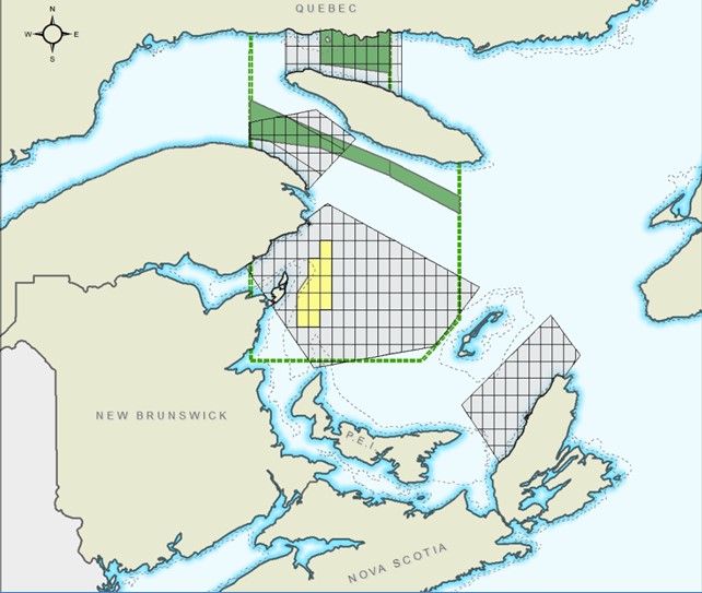
Map illustrating the static closure zone (in yellow) and the areas subject to the dynamic management protocol (in grey).
Trap limits in 2019:
In order to continue protecting NARW, all licence holders will have the same total number of authorized traps as in 2018. The following trap limits will be in place for the 2019 fishing season.
- Licence holders holding less than 0.22% of the CFA 12 TAC will be permitted 75 traps*. For 2019, this limit applies to licence holders who are part of the following fleets:
- Prince Edward Island Inshore Traditional Fleet
- Area 18 Inshore Traditional Fleet
- New access licence holders with individual quotas
- Licence holders holding 0.44% or more of the CFA 12 TAC will be permitted 150 traps*. For 2019, this represents licence holders that are part of the traditional midshore fleet.
* Note: Additional traps may be permitted in accordance with the individual transferable quota program administrative guidelines.
- New access groups who designate operators will be authorized one trap per 0.727 tonne (or 1 trap per 1,603 pounds).
- Traps may be distributed to each licence holder/operator the way that is most favorable to them; however, a maximum of 150 traps per licence holder/operator will be the reference.
- First Nations have the ability to designate operators under the Aboriginal Communal Fishing Licences Regulations. Operators designated by First Nations will be authorized one trap per 0.727 tonne (or 1 trap per 1,603 pounds).
- Traps may be distributed to each licence holder/operator the way that is most favorable to them; however, a maximum of 150 traps per licence holder/operator will be the reference.
Banc-des-Américains Marine Protected Area
On March 6, 2019, DFO created, jointly with the Quebec government, the Banc-des-Américains Marine Protected Area (MPA) in order to the ensure the conservation and protection of this marine ecosystem.
Provisions of the Banc-des-Américains Marine Protected Area Regulations apply to licence holders. In order to comply with them, please refer to the clauses that apply to your fishing activities here.

Map showing the Banc-des-Américains Marine Protected Area.
- Date modified: