
Whitby Harbour Remediation Project

Photograph provided by the Town of Whitby
On this page
- The project
- What is the problem?
- Studies completed to date
- What is the solution?
- The potential project impacts on fish and wildlife
- What are the primary risks as a result of the project activities?
- Next steps and timelines
- Contact us
The project

Whitby Small Craft Harbour is a federal property owned by Fisheries and Oceans Canada (DFO). The Town of Whitby leases the property for the Port of Whitby Marina. A portion is sub-leased to the Whitby Yacht Club.
The sediment (the soft, solid material, like sand and mud) at the bottom of the harbour contain levels of chemicals that could be harmful to fish, birds or humans. The contamination has been traced to an adjacent upstream property along Pringle Creek, and over time, the contaminated sediments were carried downstream by Pringle Creek into Whitby Harbour.
Remediation of the upstream properties along Pringle Creek started in 2008 by the province of Ontario. The sediment in Whitby Harbour and a small area of Pringle Creek needs to be cleaned up (remediated) to reduce potential risks.

Map of the Whitby small craft harbour and surrounding area including boundary lines drawn on Lake Ontario showing federal property area.
What is the problem?
- The sediments in the harbour contain high levels of chemicals called dioxins and furans
- It is known that dioxins and furans can be consumed by aquatic organisms and accumulate in the food chain. For example, fish may eat organisms that have been exposed to the chemicals, and birds or people could then eat the fish
- There are potential risks to the health of people, wildlife, and aquatic life that are exposed to the chemicals over time
- The sediment in the harbour needs to be cleaned up to reduce potential risks
Studies completed to date
- Since the early 2000s, many environmental studies at Pringle Creek and Whitby Harbour have been undertaken to determine the extent and risks of the chemicals
- Human and ecological studies were completed to assess the health risks to humans, aquatic life, and wildlife. This included taking samples of sediment, water and fish tissue and analyzing the levels of chemicals in them
- The studies found that the risks to birds and mammals are low. The risks to humans and fish are moderate and need to be managed. To reduce these risks, DFO is proposing remediation at the harbour, including sediment removal
- The Ontario Ministry of the Environment, Conservation and Parks has confirmed that the drinking water is safe. Testing of drinking water confirms that dioxins or furans have not been found in the municipal drinking water system
Project update July 2025
- Dredging work will resume in mid-July and is anticipated to continue until March 2026
- This summer, the dredging will focus in central areas of the harbour as well as areas near the mouth of Pringle Creek. Remaining work in the Marina and the Yacht club will be undertaken this coming Fall/Winter
- The harbour will remain operational during this work and boaters will continue to be able to access the marina during the boating season
- The dredging undertaken for this remediation project prioritizes precision and environmental protection. Throughout the dredging process monitoring efforts will include real-time sensors to track turbidity, which is the cloudiness or haziness of the water, and dredge positioning. Post dredge monitoring will also be undertaken to confirm the project objectives were met
Project activities as of February 2025:
The project has been awarded, and an updated design/process is being implemented:
- Following a competitive process, the contract for remediation work was awarded to Kehoe Marine Construction Ltd. of Lansdowne Ontario
- Project Summary:
- Sediment is removed through mechanical dredging and mixed with a solidification (de-watering) agent at the temporary transfer dock. Solidified material is directly trucked offsite for disposal with no temporary storage on land. Dust is not anticipated as the material is sufficiently moist to prevent it becoming airborne
- Temporary storage area (TSA) is used for water retention and treatment of any excess water from the harbour not captured by the solidification agent. A water treatment unit processes the drained water, which is then tested to ensure acceptable water quality before returning it to the Lake
- Project Timeline:
- Phase 1 work – weather permitting, dredging will continue until late March 2025
- Phase 2 work – weather permitting, dredging will resume mid-July 2025 through to March 2026, with some restrictions during fall spawning period
- Substantial project completion – temporary storage area and transfer dock removal by end of August 2026
Project activities as of January 31st, 2025:
- temporary storage area fencing and supporting facilities were established on Victoria’s field
- temporary trail constructed and in-use
- transfer dock construction completed
- temporary water tanks were used in December 2024 and January 2025, while temporary water retention pond was under construction
- dredging on-going in the area of Whitby Marina
- total contaminated sedimented dredged: 14,000 m3

The issue of contamination, and the solution of remediation - video presentation
This video presentation explains the issue of contamination, and the solution of remediation, at the Whitby Small Craft Harbour.
Whitby Harbour Remediation Project – Presentation Transcript
Slide 1 – Title Slide
Welcome to the virtual presentation for the Whitby Harbour Remediation Project. Thank you for joining us!
Slide 2 – Purpose of the Presentation
The purpose of this presentation is to provide information about the Whitby Harbour Remediation Project, plus directions on how to find out more as the Project progresses.
- This presentation will provide information about the current environmental state of Whitby Harbour, including the environmental condition and quality of the sediments, soils, and groundwater in and around the harbour
- It will also provide information about the plan to address the contaminated sediments and soils in and around Whitby Harbour
- Finally, it will provide an opportunity for you to submit questions and provide comments about this information
This presentation is being provided to comply with restrictions on public gatherings due to COVID-19. We invite you to submit your feedback through the contact information provided on our webpage and at the end of this presentation.
Slide 3 – Project Location
Whitby Harbour is a recreational harbour located on Lake Ontario, approximately 50 kilometers east of Toronto. The harbour is owned by Fisheries and Oceans Canada (also known as DFO), which is a federal department. The harbour is part of the DFO Small Craft Harbours Program. The harbour consists of two areas: an inner harbour that is approximately 40 hectares, and an outer that is approximately 220 hectares. Together, the harbour water lots cover an area of approximately 260 hectares. There are also five small adjacent land lots along the shoreline of the inner harbour that are also owned by DFO. Together the land lots cover approximately 5 hectares.
The sediments on the inner harbour bottom are contaminated and require clean up, or "remediation". The outer harbour does not require remediation. Some of the soils at the DFO-owned land lots along the inner harbour were also contaminated, but DFO has taken actions, which we will discuss later, to address the contaminated soils and groundwater. The issue of greatest concern is the contaminated sediments in the inner harbour.
Whitby Harbour is leased by the Town of Whitby, which uses the harbour for the Port of Whitby Marina. The Town of Whitby also sub-leases part of the inner harbour to the Whitby Yacht club.
Pringle Creek is located northeast of Whitby Harbour and it flows into the inner harbour. Pringle Creek is owned by the Province of Ontario.
Slide 4 – Site Usage
The map on this slide shows the different ways the inner harbour is used by the public. The areas on the map that are shaded orange are the five land lots that are owned by DFO.
The Port Whitby Marina is located at the north end of the inner harbour. The Port Whitby Marina has 420 boat slips that are mostly used for privately-owned, recreational boats.
The Whitby Yacht Club is located at the southwest end of the inner harbour. The Whitby Yacht Club has 250 boat slips and is used for recreational boating and sailing lessons. A small, sandy beach, located at the Whitby Yacht Club, is used for sailing lessons.
The Town of Whitby sometimes removes sediments from areas of Whitby Harbour, as needed, to keep the harbour deep enough for boats to use. The sediments are placed into the Town of Whitby's confined disposal facility, which is northwest of the Whitby Yacht Club.
The land surrounding the inner harbour is owned privately, or owned or leased by the Town of Whitby. A public boat launch and soccer fields are located on the northwest side of the inner harbour. The Waterfront Trail is a public walking trail that surrounds the inner harbour.
Slide 5 – Harbour Contamination
The sediments in the inner harbour contain substances of concern (or chemicals) in amounts that could be harmful to people, fish, and wildlife. The source of the contamination has been traced to an adjacent upstream property along Pringle Creek. Over time, the contaminated sediments were carried downstream by Pringle Creek into Whitby Harbour.
Some of the upstream properties on Pringle Creek were cleaned up by the Province of Ontario in 2008. A small area of Pringle Creek still requires remediation. The Province of Ontario is developing a plan to further remediate Pringle Creek.
DFO, the Province, and the Town of Whitby are working together to address the contamination in Whitby Harbour to reduce the potential risks to people, aquatic life, and wildlife. DFO is committed to reducing environmental and human health risks associated with our federal properties under the Federal Contaminated Sites Action Plan. This remediation project will consider climate change and habitat restoration goals, and will help rehabilitate the natural integrity of the harbour, creating a healthier environment for wildlife and humans alike.
Slide 6 – What are sediments? What are the substances of concern?
Sediments are the soft, solid materials (like sand and mud) that lie at the bottom of a harbour, lake, or stream.
At Whitby Harbour, the sediments in the inner harbour are contaminated with substances of concern called "dioxins and furans". Dioxins and furans are chemicals that are formed during the manufacturing of other chemicals. They can also be formed during waste incineration, the burning of fuel, or forest fires. It is common for small amounts of dioxins and furans to occur in air, water, sediments, or soils. It is difficult for dioxins and furans to decrease naturally or biodegrade, and because of this, dioxins and furans stay in the environment for a long time.
The sediments in the inner harbour need to be managed because they contain dioxins and furans at levels that could be harmful to living organisms. By reducing the volume of contaminated sediments in the inner harbour, the potential risks to people, fish, and wildlife will be reduced.
Slide 7 – What is Risk?
We use the term Risk to help understand the likelihood that there may be an unwanted or undesirable threat or effect to health. All activities have some level of risk – for example there are risks involved in driving a car but people accept the risk because of the perceived benefits and because they understand the potential risks. In the environmental world, the potential risks are studied to help everyone understand them better.
Risk can be defined as low, medium and high:
Low Risk means a level of risk that is generally acceptable to everyone. There may be some effects to a few users or species, but we monitor levels to be sure that the levels are safe.
Moderate Risk would be a risk that may be considered unsafe or unacceptable based on the potential health risks. In order to reduce moderate risks, a careful plan is required to minimize the unwanted effects.
High Risk can be thought of as a risk that is unacceptable and has a clear threat to health. This level of risk needs immediate attention to reduce the effects to humans and wildlife.
Completing a risk assessment has allowed DFO to better understand how best to approach the remediation of contaminated sediments in Whitby Harbour.
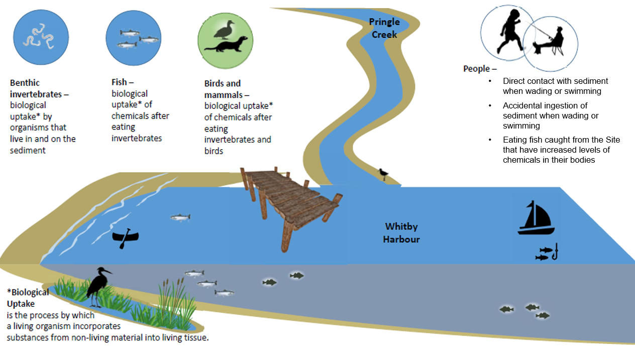
Slide 8 – Potential Risks to Human and Ecological Health
The diagram on this slide shows the ways that contaminated sediments in the inner harbour can present potential risks to both human and ecological health.
You may have heard of a process called food chain biomagnification or biological uptake, in which certain substances of concern increase in concentration in tissues as animals consume other animals. This process occurs for dioxins and furans in tissues. For example, benthic invertebrates are organisms that live in and on the sediments. Fish may eat the organisms that have been exposed to the substances of concern in the sediments. Wildlife such as birds and other mammals may then be affected by eating the fish.
Humans could also be affected by accidental consumption or skin contact with sediments when at a beach or wading in the water, or by eating fish that lived in Whitby Harbour.
Human and ecological health studies have been completed to understand the potential health risks to people, fish, and wildlife at Whitby Harbour. Potential risks to people and fish are present. This does not mean that there is an emergency, but it does mean that the contaminated sediments need to be managed to reduce the risk over time.
Risks to birds and mammals are low, but the levels of contamination in fish are high enough to cause problems for the health of the fish. There are moderate risks to people who eat fish from Whitby Harbour or who come into direct skin contact with the sediments.
Most recreational activities in and around the harbour, like sailing and hiking, are still safe because dioxins and furans are at very low concentrations in air and surface water. DFO has taken steps to minimize risks to harbour users. For example, DFO covered contaminated soils with geotextile materials, river rock, and sand at the beach area by the sailing school, and added an additional layer of gravel on the parking lot and boat storage area at the Whitby Yacht Club to minimize potential exposure to contaminated materials.
Slide 9 – Studies Completed to Date
In 2013 DFO and the provincial Ministry of the Environment, Conservation and Parks (also known as the MECP) met to discuss contamination at Whitby Harbour. Since then, extensive studies have taken place at Whitby Harbour, both in the harbour and on land to learn about the extent and magnitude of contamination. These studies included:
- sampling and analysing sediments, soils, and groundwater
- sampling and analysing fish tissues
- assessments to evaluate the risks to human and ecological health from the contaminated sediments
By completing these studies, DFO was able to better understand which areas of the harbour were contaminated and how much sediment should be removed to reduce the risks in the inner harbour.
Slide 10 – Results from Studies Completed to Date
Many studies have been completed at Whitby Harbour since the early 2000s. The table in this slide provides examples of the types of studies undertaken, the years of the studies, and the results.
In summary, these studies included sampling and chemical analysis programs for sediments, soils, groundwater, and fish tissues, biological studies, human and ecological health risk assessments, and studies about the different types of remediation methods and technologies.
The key findings from these studies included:
- Much of the sediments in the inner harbour are contaminated with chemicals known as "dioxins and furans" and the concentrations are above the federal screening values for protection of health
- Fish tissue samples from the inner harbour also contained levels of dioxins and furans that were greater than federal and provincial guidelines for the consumption of fish tissue
- Some of the soils at the DFO-owned land lots is contaminated with metals, petroleum hydrocarbons, and dioxins and furans
- There are moderate risks to human and fish health, because of the contaminated sediments. For example, fish may eat organisms that have been exposed to the chemicals in the sediments. Also, people could be exposed to contaminated sediments if they wade or swim in Whitby Harbour and directly touch the sediments. There are also low risks for humans that come into contact with soils contaminated with dioxins and furans on DFO lands adjacent to the harbour
- Dredging, or excavating, the contaminated sediments was identified as the preferred way to remove contaminated sediments from the inner harbour. The contaminated sediments will be transported off-site to be safely disposed of at a permitted landfill facility
Slide 11 – Sediment Remediation Options
DFO studies have resulted in three viable remediation options. These options are referred to as low intervention, moderate intervention, and high intervention. The difference between the options is the amount, or volume, of sediments that would be removed from the inner harbour.
The image on this slide shows the high intervention option. The low, moderate, and high intervention levels are shown and compared on the next slide.
On the figure, the red and dark orange areas show those parts of the inner harbour with the highest levels of dioxins and furans. The lighter orange areas have fewer dioxins and furans, and then the yellow and green areas show those parts of the inner harbour with the lowest levels of dioxins and furans. The blue hatched areas cover the red and dark orange areas, where the levels of dioxins and furans are highest, and also show the proposed areas of the inner harbour where sediments would be removed during dredging, under the high intervention option. These areas are not exact—they will be refined as part of the detailed design phase of the remediation plan, and could be slightly smaller or larger than shown here.
The high intervention option is proposed as the best option for the remediation of Whitby Harbour to reduce the potential risks to human and ecological health.
Slide 12 – Sediment Remediation Options
The images on this slide show the three different levels of remediation that were studied by DFO. The levels are referred to as high intervention, moderate intervention, and low intervention. The difference between the options is the amount, or volume, of sediment that could be removed from the inner harbour. The low intervention option would remove the least amount of sediment and the high intervention option would remove the greatest amount of sediment.
Specifically, approximately 120,000 m3 of sediment would be removed with the high intervention option, 60,000 m3 with the medium intervention option, and 30,000 m3 with the low intervention option.
Slide 13 – Proposed Remediation Activities
The goal of the remediation project is to remove the sediments with the highest amounts of dioxins and furans in it. This will reduce the average concentration in sediments, and over time this will also reduce the concentrations available to fish and other animals that take up dioxins and furans. By doing this, the risk to people, fish, and wildlife will be greatly reduced.
It is not necessary to remove 100% of the dioxins and furans in the sediments. These substances are found in very small amounts in many places, including supermarket foods and in soils or sediments in many environments. The goal is to remove the sediments with the highest amounts of chemicals to reduce the risks in Whitby Harbour.
To remove the sediments, a technique called dredging will be used as the main technique. The sediments will be dewatered on land, and then transported by truck to be safely disposed of at a permitted landfill facility.
Slide 14 – Why is dredging the preferred solution?
Several remedial methods and technologies for the removal of contaminated sediments were studied. Dioxins and furans do not readily decrease or biodegrade in the environment, so a physical method to manage the contaminated sediments is needed.
The physical removal of the contaminated sediments is the best way to reduce the risks to people, fish, and wildlife. Other methods, like adding special chemicals to the sediments to clean them, or placing a clean layer on top of the sediments, cannot be conducted in most areas of the harbour without impacting access and the ability to use the harbour for boating. Leaving the sediments to clean-up naturally will not work either, because the chemicals take too long to break down.
You may have questions about the disruption to the environment during the dredging. DFO is currently evaluating ways to physically remove contamination while also minimizing disturbance to harbour users and natural habitats. The remediation plan will contain the contamination and minimize impacts to the natural environment as much as possible. For example, sensitive habitats and species at risk will be identified and protected wherever possible, and silt curtains will be placed as needed around the work area to prevent displaced sediments, referred to as turbidity, from affecting water quality. A detailed monitoring plan will be prepared to protect the environment both during and after dredging.
Dredging is already used to remove extra sediments that builds up in Whitby Harbour over time. This is done every couple of years so that the inner harbour can remain deep enough for boating. The remediation program will apply similar approaches, but at a broader scale.
Slide 15 – DFO-Owned Land Lots
In 2019, the risks to human and ecological health from the contaminated soils and groundwater on the land lots were studied.
There was no risk associated with the groundwater, and no action was needed.
The risks to people were identified to be low in relation to the dioxins and furans in soil.
Some work has already been completed by DFO at the land lots to address the contaminated soils and to reduce potential risks. Layers of clean cover, including sand and river rock, and geotextile materials were placed over contaminated soils at the beach area by the sailing school, and an additional layer of gravel was added to the parking lot and boat storage area at the Whitby Yacht Club. The layer of clean materials minimizes the potential for people or wildlife to come into contact with the contaminated materials.
DFO will continue to monitor the condition of the cover materials at the Whitby Yacht Club.
Slide 16 – Human Health and Site Use
It is still safe to participate in recreational activities in and around the harbour, such as sailing and hiking. Catch and release fishing is allowed, but a Provincial fish consumption advisory is in place at the harbour and signs have been posted about this.
Shoreline modifications were completed by DFO in 2019. This will prevent people and wildlife from directly contacting the contaminated soils.
Ontario has a comprehensive drinking water protection framework from source to tap. Since reporting began in 2004, more than 99.8% of water quality tests continue to meet Ontario's strict health-based water quality standards. When you turn on your tap, you can be confident that your drinking water is among the best protected in the world. For more information on Ontario’s commitment to delivering safe drinking water, please visit the webpage www.ontario.ca/page/source-protection.
Slide 17 – Next Steps and Timelines
The diagram on this slide shows the key milestones and approximate timing for the next steps of the Project. Planning for remediation work is ongoing and input received will help inform this process.
Currently, the following Project timeline is as follows:
- The Project Update was launched in February 2022, to notify people about the Project and the Project Website
- An update about the Remedial Action Plan for the Project is expected to be made in Fall 2022
- Following this, the detailed design work will start, including submitting applications and requests for permits to achieve the appropriate regulatory approvals to proceed with the Project
- As part of the development of the remedial action plan and detailed design, an evaluation of environmental effects will be completed in accordance with the federal Impact Assessment Act to ensure that mitigation measures are incorporated into the project
- The remediation work at the inner harbour will begin when the applications and permits are approved
- Finally, once remediation work has been completed, the site will be monitored in accordance with a Post-remediation Monitoring Plan to ensure that the substances of concern have been adequately removed and the remediation objectives have been met. The Post-remediation Monitoring Plan will be developed during the detailed design phase of the work
Slide 18 – How to Learn More
The Project website www.dfo-mpo.gc.ca/whitby-harbour has a number of resources available from which you can learn more about the Project. This includes:
- A PDF copy of this presentation
- A transcript of this presentation
- A Project Information Pamphlet
- Site map
Slide 19 – How to Get in Touch
Your input is important.
Details about how to get in touch with the project team are provided on this slide. Comments and questions are always welcome by phone, email or letter mail. DFO can be contacted by email at DFO.OPInfoWhitbyMPO@dfo-mpo.gc.ca, by phone at 833-551-2702 or by mail at Fisheries and Oceans Canada, Whitby Harbour Project, 520 Exmouth Street, Sarnia, ON, N7T 8B1.
This presentation will remain available on the project website. The Project website will be available throughout the Project and updated periodically should you wish to access information as the Project progresses.
We welcome your comments and questions and look forward to hearing from you.
Slide 20 – Thank You!
Thank you for visiting the Project website.
What is the solution?
- DFO and the Province of Ontario have studied the contaminated sediment and the potential harm or “risk” to humans, wildlife, and aquatic life over several decades
- DFO is developing a plan to clean up Whitby Harbour, and the Province of Ontario is developing plans to clean up Pringle Creek
- DFO plans to remove contaminated sediment from the harbour and take it to an offsite landfill for proper disposal
- A provincial fish consumption advisory is in place at the harbour and signs have been posted about this
The plan to clean up Whitby harbour
Fisheries and Oceans Canada (DFO) recently developed a Remedial Action Plan (RAP) to guide the cleanup (remediation) of Whitby Harbour.
The RAP aims to reduce potential risks to the health of people, fish, and wildlife, that are associated with long term exposure to the chemicals found in Whitby Harbour. This will be achieved by removing contaminated sediment from the harbour, which will reduce harbour-wide dioxin and furan levels. Dioxins and furans are a group of chemicals which do not readily break down. They remain in the environment for a long time and accumulate in food chains. The source of the contamination is unknown, but as owners of the harbour, DFO has taken on the responsibility for cleaning up the site.
Contaminated sediment is expected to be removed via dredging and placed in a temporary de-watering area. This area will be designed to allow clean water to drain from the sediment, while ensuring controls are in place to direct the flow and reduce turbidity of water re-entering the harbour, while ensuring controls are in place to direct the flow and reduce turbidity of water re-entering the harbour. De-watered materials will then be trucked off-site to a licensed disposal facility. Project implementation will require the use of heavy equipment, site access, and the use of nearby municipal lands, and will result in increased traffic in the area at times. The remedial action plan identifies mitigation and monitoring measures that will be applied prior to, during, and after construction to reduce potential impacts to people, fish and wildlife. While some disruption to boaters, nearby landowners, and the broader community may occur, DFO is committed to minimizing these potential impacts.
What is a remedial action plan?
The remedial action plan presents the approach that will be used to clean up (remediate) contaminated sediments in Whitby Harbour. It outlines remediation requirements, including preferred construction methods, measures to protect the environment, wildlife and people, and monitoring requirements for before, during and after the work to ensure the project was successful. The remedial action plan sets the stage for the design phase, during which detailed plans will be developed for completing the cleanup.
- Refines
- Identifies
- Protects
- Monitor
The remedial action plan lays out the framework for the remediation project, and the next step is to proceed with the design phase, which provides detailed plans for each component of the project.
- Step 1: Refine framework through engagement
- Step 2: Design phase
DFO welcomes feedback from landowners, boaters, site users, and the broader community.
The potential project impacts on fish and wildlife
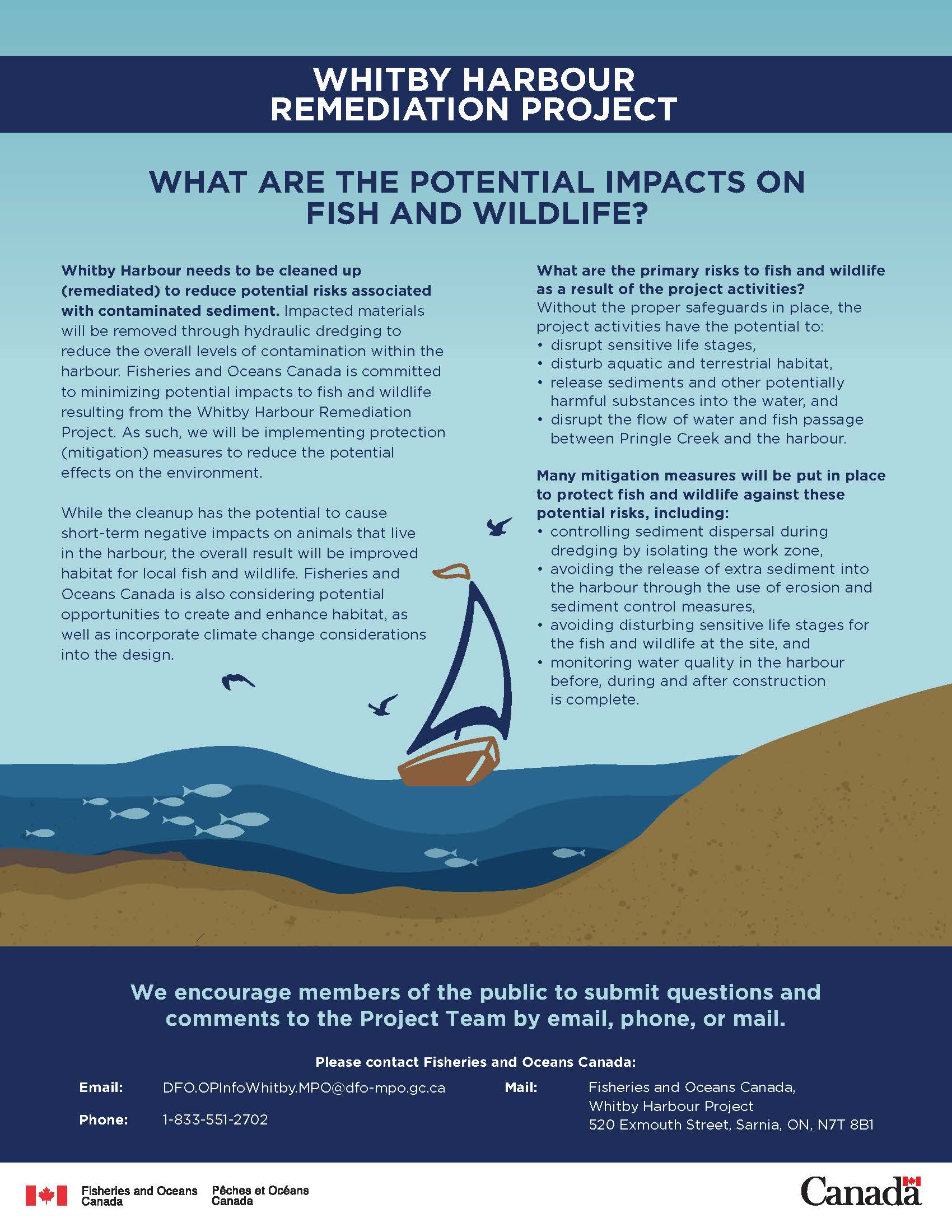
Whitby Harbour needs to be cleaned up (remediated) to reduce potential risks associated with contaminated sediment. Impacted materials will be removed through hydraulic dredging to reduce the overall levels of contamination within the harbour. Fisheries and Oceans Canada is committed to minimizing potential impacts to fish and wildlife resulting from the Whitby Harbour Remediation Project. As such, we will be implementing protection(mitigation) measures to reduce the potential effects on the environment.
While the cleanup has the potential to cause short-term negative impacts on animals that live in the harbour, the overall result will be improved habitat for local fish and wildlife. Fisheries and Oceans Canada is also considering potential opportunities to create and enhance habitat, as well as incorporate climate change considerations into the design.
What are the primary risks as a result of the project activities?
Without the proper safeguards in place, the project activities have the potential to:
- disrupt sensitive life stages
- disturb aquatic and terrestrial habitat
- release sediments and other potentially harmful substances into the water
- disrupt the flow of water and fish passage between Pringle Creek and the harbour
Many mitigation measures are being put in place to protect fish and wildlife against these potential risks, including:
- controlling sediment dispersal during dredging by isolating the work zone
- avoiding the release of extra sediment into the harbour through the use of erosion and sediment control measures
- avoiding disturbing sensitive life stages for the fish and wildlife at the site
- monitoring water quality in the harbour before, during and after construction is complete
Next steps and timelines

- The Project Update was launched in February 2022, to notify people about the Project and the Project Website and will continue to be updated regularly as the Project progresses
- An updated Remedial Action Plan for the Project was received in January 2023, a slight delay from our projected timeline of Fall 2022
- Detailed design was completed at the end of June 2024 and the tender was posted on CanadaBuys. Applications for permit approvals have also been completed
- As part of the development of the remedial action plan and detailed design, the evaluation of environmental effects was completed in accordance with the federal Impact Assessment Act to ensure that mitigation measures are incorporated into the project and implemented by the contractor
- The remediation work at the inner harbour is expected for Fall 2024 when the applications and permits are approved
- Once remediation work has been completed, a Post-remediation Monitoring Plan will be implemented to ensure that the contaminants of concern are reduced and the remediation objectives have been met. The Post-remediation Monitoring Plan is being finalized at this time
Contact us
We welcome your questions and comments. Please contact Fisheries and Oceans Canada:
- Email: DFO.OPInfoWhitby.MPO@dfo-mpo.gc.ca
- Telephone: 1-833-551-2702
- Mail: Fisheries and Oceans Canada,
Whitby Harbour Project
520 Exmouth Street,
Sarnia, ON, N7T 8B1
- Date modified: