
Threats to fish and fish habitat in the watersheds of Nova Scotia
Read about freshwater fish and fish habitat across Nova Scotia and examples of initiatives that Fisheries and Oceans Canada (DFO) is leading or supporting with partners to help address threats.
On this page
- Overview of fish and fish habitat in Nova Scotia
- Habitat highlight: Assessing aquatic connectivity in Nova Scotia
For information on marine ecosystems, please refer to DFO’s State of the Atlantic Ocean report series.
Overview of fish and fish habitat in Nova Scotia
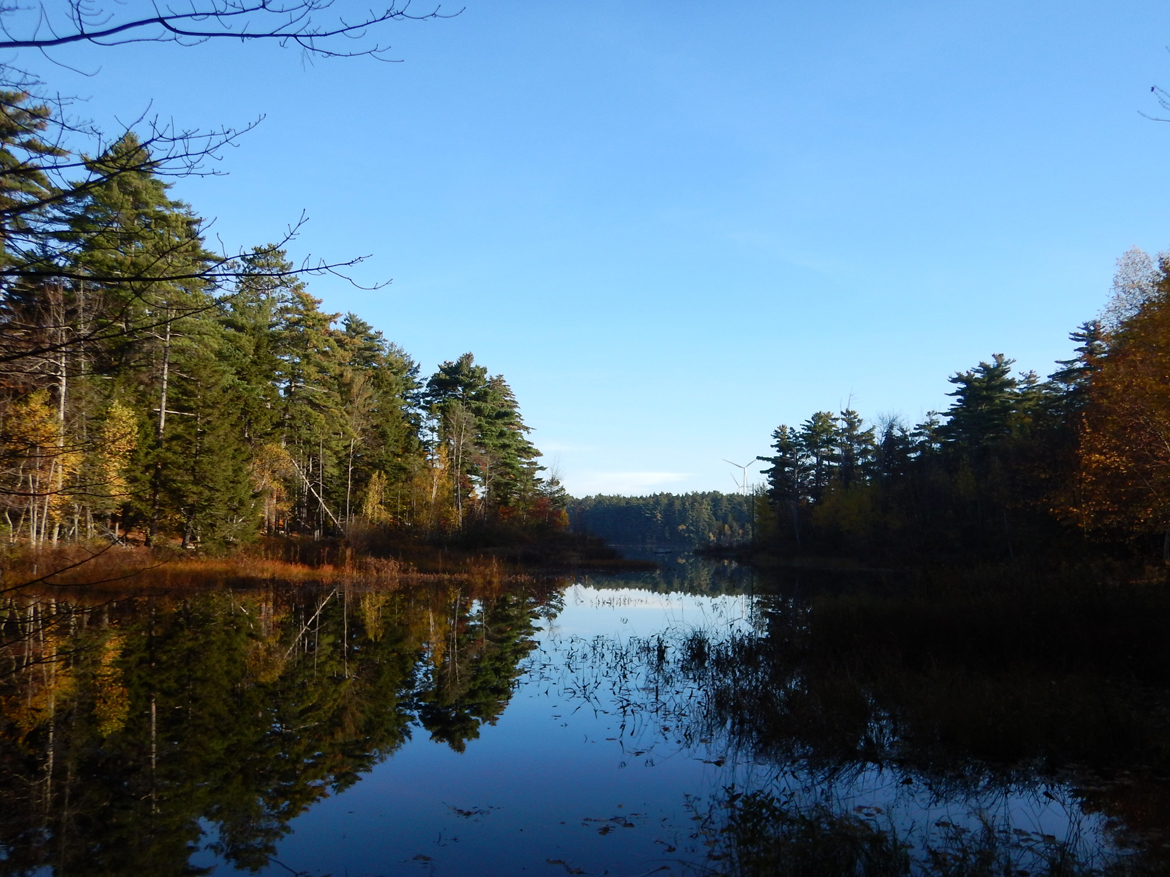
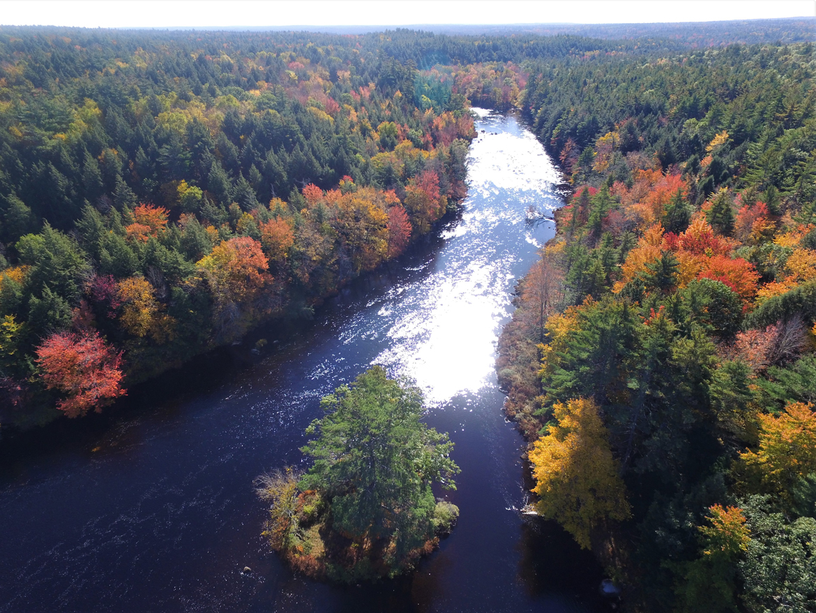
Geography
Nova Scotia has several thousand kilometres of coastline, thousands of lakes, and hundreds of rivers and wetlandsFootnote 1. The province is characterized by dense networks of small streams, lakes, and bogs which have been influenced by historic glaciation, large areas of impermeable rock, and thin soilsFootnote 2. Unlike other provinces that are dominated by a few large watersheds, Nova Scotia has many smaller watersheds that flow directly into the ocean. The map below shows the 46 primary watersheds in Nova Scotia that drain into four different coastal regions: Atlantic Ocean, Bay of Fundy-Gulf of Maine, Northumberland Strait, and Cape Breton Island-Bras d’Or LakesFootnote 3.
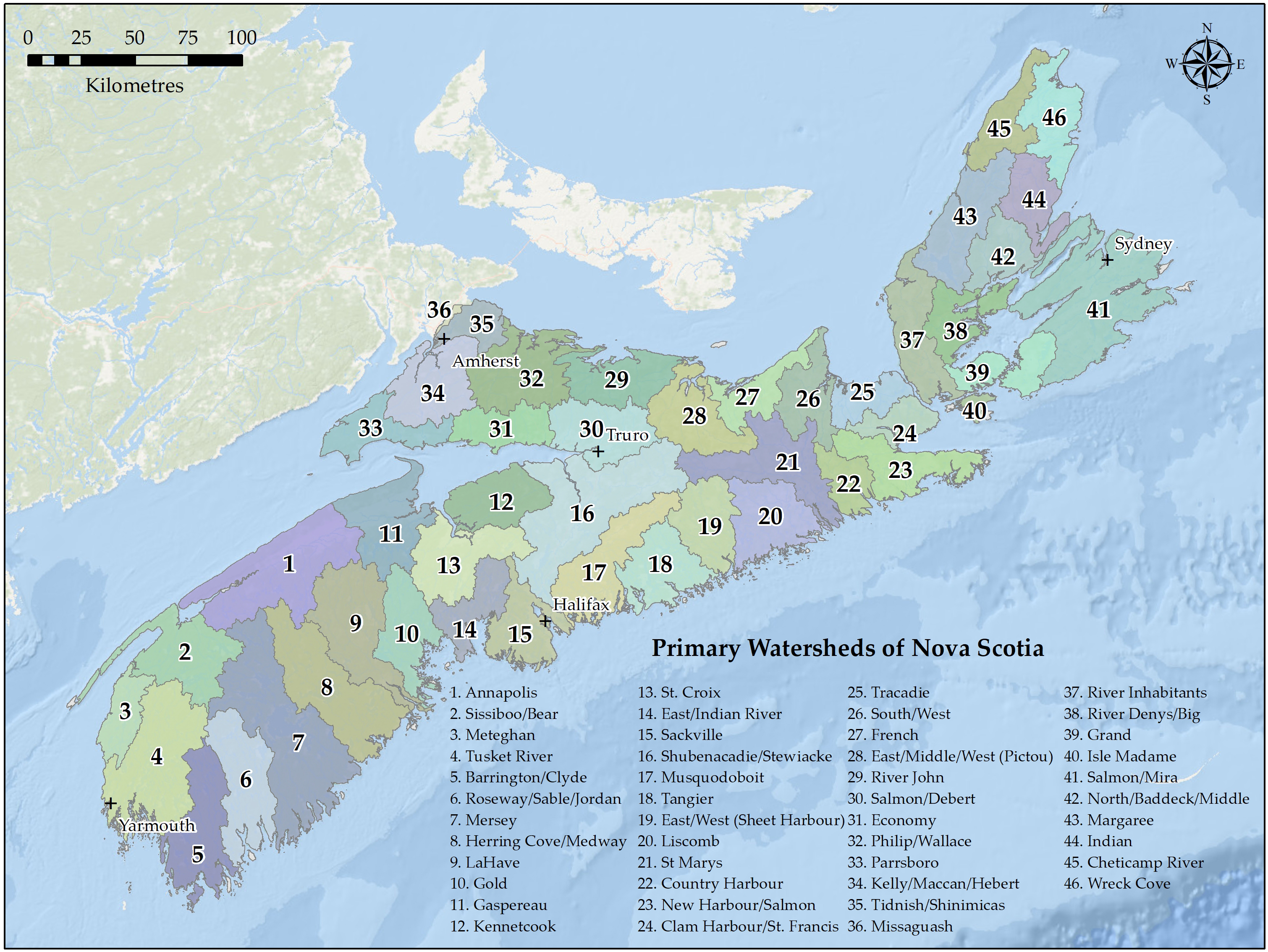
Primary watersheds of Nova Scotia - Text version and data sources
Primary watersheds of Nova Scotia
- Annapolis
- Sissiboo/Bear
- Meteghan
- Tusket River
- Barrington/Clyde
- Roseway/Sable/Jordan
- Mersey
- Herring Cove/Medway
- LaHave
- Gold
- Gaspereau
- Kennetcook
- St. Croix
- East/Indian River
- Sackville
- Shubenacadie/Stewiacke
- Musquodoboit
- Tangier
- East/West (Sheet Harbour)
- Liscomb
- St Marys
- Country Harbour
- New Haarbour/Salmon
- Clam Harbout/St. Francis
- Tracadie
- South/West
- French
- East/Middle/West (Pictou)
- River John
- Salmon/Debert
- Economy
- Philip/Wallace
- Parrsboro
- Kelly/Maccan/Hebert
- Tidnish/Shinimicas
- Missaguash
- River Inhabitats
- River Denys/Big
- Grand
- Isle Madame
- Salmon/Mira
- North/Baddeck/Middle
- Margaree
- Indian
- Cheticamp River
- Wreck Cove
Data sources for base map
General Bathymetric Chart of the Oceans GEBCO_08 Grid, National Oceanic and Atmospheric Administration, National Geographic, Garmin, HERE, Geonames.org, and Esri.
Aquatic species
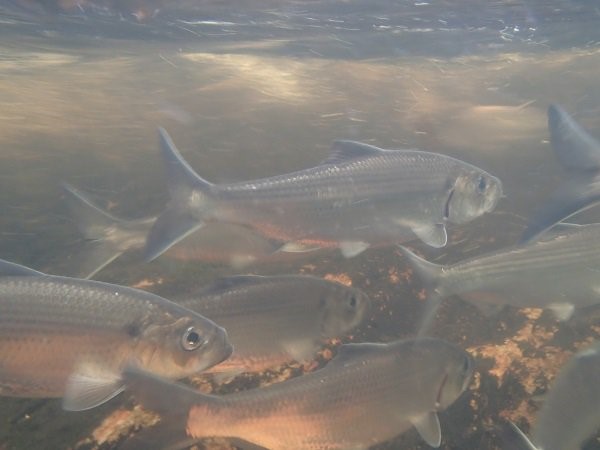
More than 40 different fish species are found in Nova Scotia’s freshwater areas (lakes and rivers); some of the most recognized are members of the salmonid family, including Atlantic salmon and several species of trout, such as brook trout and lake trout. Other species native to Nova Scotia include:
- freshwater species, such as banded killifish, brown bullhead, common shiner, white perch, yellow perch, and Atlantic whitefish
- anadromous species, such as American shad, Atlantic sturgeon, gaspereau, Atlantic tomcod, rainbow smelt, and striped bass
- catadromous species, such as American eel
Species names in Mi’kmaw language
American eel: Katew/ Kataq
Atlantic salmon: Plamu/ Plamu’k
Atlantic sturgeon: Komkutamu/ Komkutamu’k
Atlantic whitefish: Alanj/ Alanjik
Brook floater: N’kata’law/ N’kata’laq
Striped bass: Ji’kaw/ Ji’kawk
Yellow lampmussel: N’kata’law/ N’kata’laq
Source: Mi’kmaw Conservation Group
Four species found in Nova Scotia are listed under the Species at Risk Act (SARA):
Several other species found in the province have been assessed as “at risk” by the Committee on the Status of Endangered Wildlife (COSEWIC) in Canada and are awaiting a decision regarding listing under the Species at Risk Act:
- American eel
- Atlantic sturgeon (Maritimes populations)
- Atlantic salmon (Southern Upland and Eastern Cape Breton populations)
- striped bass (Bay of Fundy population)
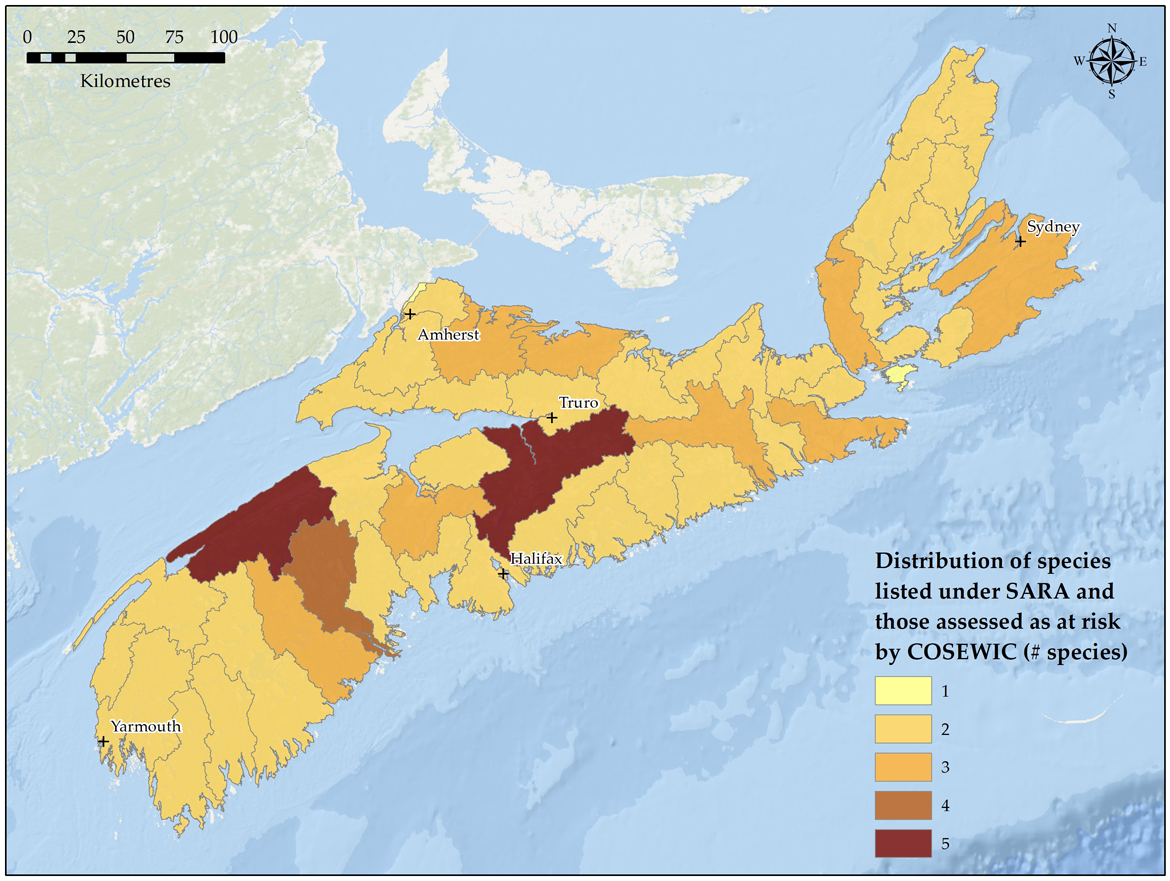
Map: Distribution of both species listed under the Species at Risk Act and those assessed as "at risk" by the Committee on the Status of Endangered Wildlife in Canada - Text version and data sources
Data sources and methods
The mapping of species at risk (SAR) in NS primary watersheds made use of available geographic information provided in various SAR recovery publications for each species. Each of the publications used for this exercise contained maps and/or geographic information (e.g. river names) identifying the presence of a given species. These locations were plotted in the ArcGIS environment to determine which NS primary watersheds contained the presence of a species at risk. The final map products presented in this report depict the total number of species at risk present for a given watershed, ranging from 1 to 5 species. The mapping included both SARA listed species and COSEWIC assessed species.
Please refer to the following table for the SAR recovery publication used for each species:
| Primary Watershed | Number of Species at Risk |
|---|---|
| Annapolis | 5 |
| Barrington / Clyde | 2 |
| Cheticamp River | 2 |
| Clam Harbour / St. Francis | 2 |
| Country Harbour | 2 |
| East / Indian River | 2 |
| East / Middle / West (Pictou) | 2 |
| East / West (Sheet Harbour) | 2 |
| Economy | 2 |
| French | 2 |
| Gaspereau | 2 |
| Gold | 2 |
| Grand | 2 |
| Herring Cove / Medway | 3 |
| Indian | 2 |
| Isle Madame | 1 |
| Kelly / Maccan / Hebert | 2 |
| Kennetcook | 2 |
| LaHave | 4 |
| Liscomb | 2 |
| Margaree | 2 |
| Mersey | 2 |
| Meteghan | 2 |
| Missaguash | 1 |
| Musquodoboit | 2 |
| New Harbour / Salmon | 3 |
| North / Baddeck / Middle | 2 |
| Parrsboro | 2 |
| Philip / Wallace | 3 |
| River Denys / Big | 2 |
| River Inhabitants | 3 |
| River John | 3 |
| Roseway / Sable / Jordan | 2 |
| Sackville | 2 |
| Salmon / Debert | 2 |
| Salmon / Mira | 3 |
| Shubenacadie / Stewiacke | 5 |
| Sissiboo / Bear | 2 |
| South / West | 2 |
| St. Croix | 3 |
| St. Mary’s | 3 |
| Tangier | 2 |
| Tidnish / Shinimicas | 2 |
| Tracadie | 2 |
| Tusket River | 2 |
| Wreck Cove | 2 |
Data sources for base map
General Bathymetric Chart of the Oceans GEBCO_08 Grid, National Oceanic and Atmospheric Administration, National Geographic, Garmin, HERE, Geonames.org, and Esri.
Profile: Atlantic whitefish
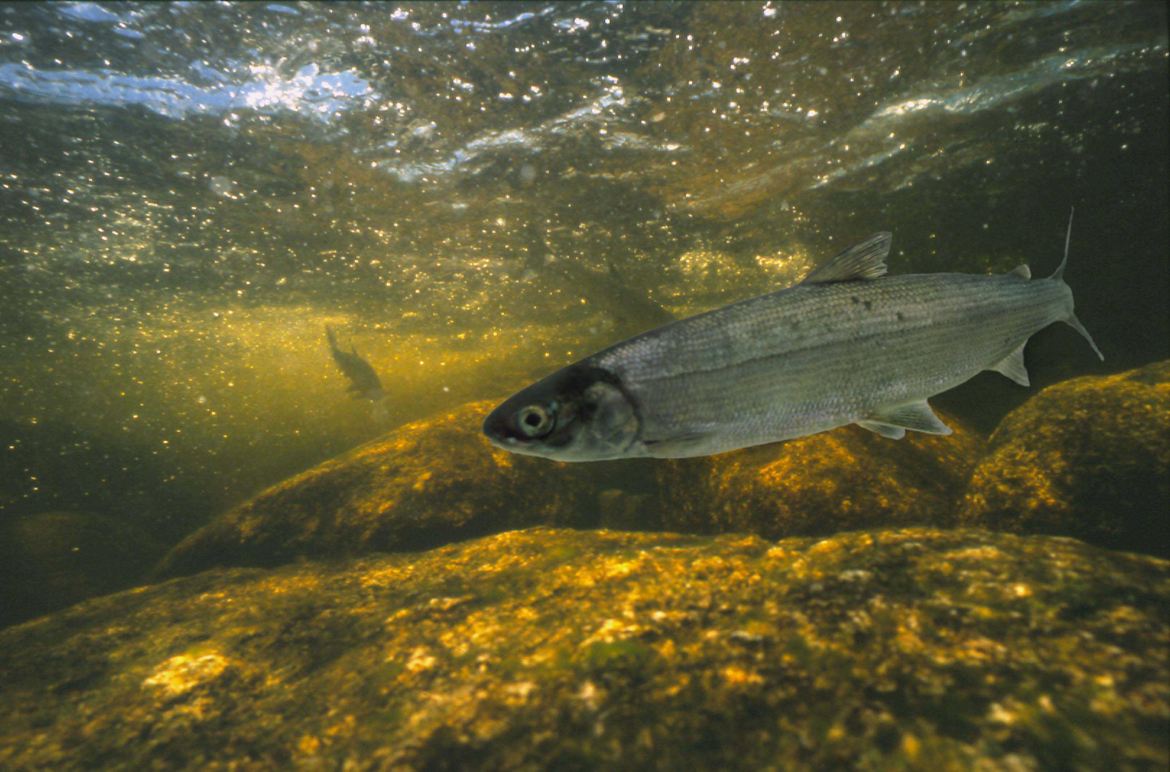
Nova Scotia is home to the Atlantic whitefish, a species found nowhere else in the world. Belonging to the salmon and trout family (Salmonidae), Atlantic whitefish are similar in appearance, but genetically distinct from, lake whitefish. Once found in two watersheds in Nova Scotia, its population is now limited to three small, interconnected lakes within the upper Petite Rivière watershed. The size of the population in the Petite Rivière is unknown but is likely very small. Interactions with aquatic invasive species, specifically smallmouth bass and chain pickerel, pose a significant threat to the survival of this last remaining population of Atlantic whitefish.
Profile: Atlantic salmon
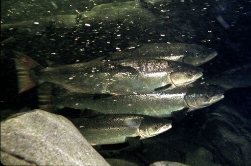
Atlantic salmon are an iconic species in Nova Scotia ecologically and culturally, with particular social and cultural importance to Indigenous Peoples. As an anadromous species, salmon require a variety of freshwater, estuarine, and marine habitats throughout their life cycle (Salmon life cycle).
There are multiple populations, or designatable units, of Atlantic salmon, which are identified based on geographic and genetic differencesFootnote 4. In order to evaluate the status of Atlantic salmon in Nova Scotia, scientists at DFO have conducted monitoring in a number of index rivers. The methodology compares an estimate of the salmon eggs deposited with the number of eggs that would be required to conserve each index populationFootnote 5.
Significant populations include:
-
Inner Bay of Fundy
COSEWIC status: Endangered
SARA status: EndangeredIndex river (NS):
- Gaspereau River
Key metrics from the most recent assessment of the index riverFootnote 6:
- below the conservation egg requirement (egg deposition estimated to be below 10% of the conservation egg requirement in 15 of the 17 years assessed below the White Rock dam)
- smolt-to-adult return rates are very low (below 1%) and have been so in each year assessed
- in 2019, 22 adults returned to spawn in the Gaspereau
For more information:
Review of the Inner Bay of Fundy Atlantic Salmon (Salmo salar) Monitoring Activities Associated with the Live Gene Bank -
Southern Upland
COSEWIC status: Endangered
SARA status: under considerationIndex river (NS):
- LaHave River
Key metrics from the most recent assessment of the index riverFootnote 7 (DFO 2020):
- below the conservation egg requirement in 2019 (egg deposition estimated at 4% of conservation egg requirements)
For more information:
Stock Status Update of Atlantic Salmon in Salmon Fishing Areas (SFAs) 19–21 and 23 -
Eastern Cape Breton
COSEWIC status: Endangered
SARA status: under considerationIndex rivers (NS):
- Middle River
- Baddeck River
- North River
Key metrics from the most recent assessment of the index riverFootnote 8:
- Middle and Baddeck rivers: below the conservation egg requirement in 2020 (egg deposition estimated at 70 and 64% respectively of conservation egg requirements)
- North river: above the conservation egg requirement in 2020 (egg deposition estimated to be 102% of the conservation egg requirement)
- trends on all three rivers have been relatively stable over the past two decades of monitoring
For more information:
Stock Status Update of Atlantic Salmon in Salmon Fishing Areas (SFAs) 19–21 and 23 -
Gaspe-Southern Gulf of St. Lawrence
COSEWIC status: Special concern
SARA status: under considerationIndex rivers (NS):
- West River (Antigonish)
- River Philip
- East River (Pictou)
- Margaree River
Key metrics from the most recent assessment of the index riverFootnote 9:
- over the recent 12-year period, the catch rates of large salmon declined by 8% in West River (Antigonish) and by 31% in East River (Pictou). Catch rates of large salmon in River Philip increased 169% over the same time period
- declines in catch rates of small salmon over the recent 12-year period was noted on all three rivers: 70% for West River (Antigonish), 69% for East River (Pictou), and 13% for River Philip
- trends in catch rates over the recent 12 years show a decline of 23% for large salmon and 45% for small salmon in Margaree River
For more information:
Update of indicators of Atlantic Salmon (Salmo salar) in DFO Gulf Region Salmon Fishing Areas 15 - 18 for 2018
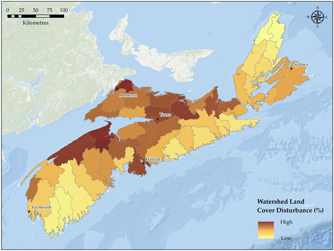
Land use
Land cover disturbance was assessed for Nova Scotia by determining the combined percentage of each primary watershed that was classified as urban development, forest loss, or agriculture. Note that forest loss includes areas impacted by forest harvesting, as well as forest loss due to other natural processes (e.g. fires, storms). The watersheds in central Nova Scotia show the highest levels of disturbance from these combined land uses, while watersheds in southwest Nova Scotia, the eastern shore, and Cape Breton are subject to less land use disturbance.
Land cover disturbance by watershed across Nova Scotia - Text version and data sources
Data sources and methods
Watershed land cover disturbance products were produced using an adapted methodology from the Nature Conservancy of Canada’s Watershed Health AssessmentFootnote 10. The analysis was completed using various Landsat-derived land cover products (30 m resolution) to identify areas of urban development, agricultural areas, and forest loss.
Areas classified as urban development in NS watersheds were identified using 2 data sources:
- urban land cover, extracted from the NRCan - Canada Centre for Remote Sensing’s 2015 Land Cover of Canada
- urban impervious surface, available from the Global Man-made Impervious Surface (GMIS) (2010)Footnote 11
Agricultural land cover areas were identified using 2 data sources:
- cropland, extracted from the NRCan - Canada Centre for Remote Sensing’s 2015 Land Cover of Canada
- pasture/forages, extracted from Agriculture and Agri-food Canada’s 2021 Annual Crop Inventory
Areas of forest loss were identified using data available from Global Forest Watch (2021), and included areas identified as gross forest loss for the period of 2011-2021. It should be noted that forest loss includes areas impacted by forest harvesting, as well as forest loss due to other natural processes (e.g. fires, storms). This dataset should also be interpreted as gross forest loss, so areas of forest gain (e.g. regeneration following forest harvesting) are not captured.
To generate the disturbance values at the watershed scale, raster datasets were generated using the aforementioned land cover disturbance datasets within the ArcGIS Desktop environment. These raster products were created for each disturbance type (urban, agriculture, and forest loss), and for a single composite disturbance dataset capturing all disturbance types. The total and individual disturbance type areas (km²) were then calculated for each primary watershed and divided by the total watershed area to derive the final watershed disturbance values.
| Primary Watershed | Watershed Disturbance (%) |
|---|---|
| Annapolis | 28.86 |
| Barrington / Clyde | 6.19 |
| Cheticamp River | 3.02 |
| Clam Harbour / St. Francis | 17.84 |
| Country Harbour | 12.81 |
| East / Indian River | 14.55 |
| East / Middle / West (Pictou) | 29.52 |
| East / West (Sheet Harbour) | 15.43 |
| Economy | 19.19 |
| French | 23.08 |
| Gaspereau | 41.27 |
| Gold | 19.83 |
| Grand | 17.89 |
| Herring Cove / Medway | 15.37 |
| Indian | 9.30 |
| Isle Madame | 17.32 |
| Kelly / Maccan / Hebert | 24.20 |
| Kennetcook | 20.81 |
| LaHave | 20.03 |
| Liscomb | 12.05 |
| Margaree | 11.47 |
| Mersey | 8.17 |
| Meteghan | 24.24 |
| Missaguash | 21.53 |
| Musquodoboit | 17.65 |
| New Harbour / Salmon | 9.59 |
| North / Baddeck / Middle | 14.50 |
| Parrsboro | 24.57 |
| Philip / Wallace | 24.35 |
| River Denys / Big | 14.59 |
| River Inhabitants | 17.26 |
| River John | 26.75 |
| Roseway / Sable / Jordan | 6.32 |
| Sackville | 28.62 |
| Salmon / Debert | 27.10 |
| Salmon / Mira | 18.56 |
| Shubenacadie / Stewiacke | 25.14 |
| Sissiboo / Bear | 17.70 |
| South / West | 25.74 |
| St. Croix | 25.69 |
| St. Mary’s | 16.08 |
| Tangier | 10.53 |
| Tidnish / Shinimicas | 30.09 |
| Tracadie | 25.19 |
| Tusket River | 15.30 |
| Wreck Cove | 4.06 |
Data sources for base map
General Bathymetric Chart of the Oceans GEBCO_08 Grid, National Oceanic and Atmospheric Administration, National Geographic, Garmin, HERE, Geonames.org, and Esri.
Riparian habitat
The amount of riparian disturbance was assessed for Nova Scotia by determining the combined percentage of a 150 m riparian zone within each primary watershed that was classified as urban development, forest loss, or agriculture. The land use patterns in the riparian zone show similar patterns to the overall watershed land use patterns with the watersheds in central Nova Scotia showing the highest levels of riparian disturbance from these combined land uses.
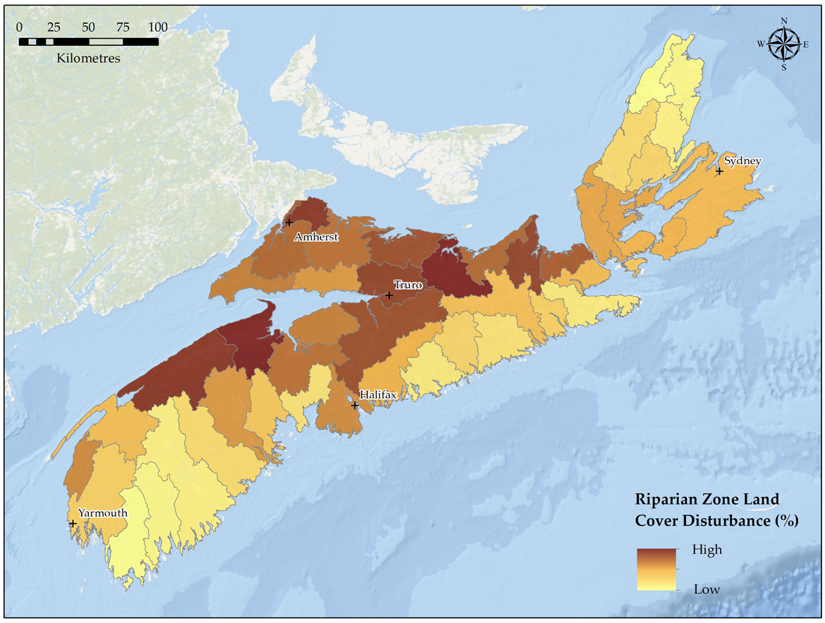
Riparian zone land cover disturbance by watersheds across Nova Scotia - Text version and data sources
Data sources and methods
Making use of the same land cover disturbance products discussed above, the riparian analysis scaled down the spatial scope of the analysis to a riparian focus within each watershed. To define the riparian area, a 150 m buffer was applied to all watercourses and waterbodies (1:50,000 Canvec Hydrographic Features). The 150 m buffer was selected to coincide with the 30 m resolution land cover disturbance rasters, which resulted in a 10-pixel spatial footprint surrounding watercourse features. For future analyses using a finer scale raster product, a smaller buffer distance would be recommended.
Land cover disturbance area calculations were replicated for the riparian analysis using both the total composite disturbance and individual disturbance types within the riparian area of each primary watershed. These values were then divided by the total riparian area of each primary watershed to generate the total riparian disturbance values.
All final land cover map products are presented using a quantile classification, in which each class contains an equal number of watersheds. For example, the watersheds with the 2 lowest percentages of disturbance fall within the first class, while the watersheds with the 2 highest percentages of disturbance are within the last class. Darker colours indicate watersheds with a higher amount of disturbance, while lighter colours are indicative of a lower amount of disturbance.
| Primary Watershed | Riparian Disturbance – 150 m Buffer (%) |
|---|---|
| Annapolis | 30.43 |
| Barrington / Clyde | 3.69 |
| Cheticamp River | 2.56 |
| Clam Harbour / St. Francis | 14.81 |
| Country Harbour | 11.47 |
| East / Indian River | 9.66 |
| East / Middle / West (Pictou) | 30.64 |
| East / West (Sheet Harbour) | 11.19 |
| Economy | 17.25 |
| French | 23.84 |
| Gaspereau | 41.14 |
| Gold | 13.92 |
| Grand | 15.37 |
| Herring Cove / Medway | 10.19 |
| Indian | 5.83 |
| Isle Madame | 13.53 |
| Kelly / Maccan / Hebert | 23.49 |
| Kennetcook | 20.02 |
| LaHave | 15.66 |
| Liscomb | 8.03 |
| Margaree | 9.72 |
| Mersey | 4.73 |
| Meteghan | 18.36 |
| Missaguash | 24.40 |
| Musquodoboit | 14.93 |
| New Harbour / Salmon | 6.85 |
| North / Baddeck / Middle | 11.23 |
| Parrsboro | 21.96 |
| Philip / Wallace | 23.18 |
| River Denys / Big | 15.38 |
| River Inhabitants | 15.51 |
| River John | 26.09 |
| Roseway / Sable / Jordan | 4.31 |
| Sackville | 19.20 |
| Salmon / Debert | 29.55 |
| Salmon / Mira | 14.64 |
| Shubenacadie / Stewiacke | 25.31 |
| Sissiboo / Bear | 14.34 |
| South / West | 26.54 |
| St. Croix | 23.34 |
| St. Mary’s | 14.19 |
| Tangier | 6.10 |
| Tidnish / Shinimicas | 30.45 |
| Tracadie | 25.08 |
| Tusket River | 11.46 |
| Wreck Cove | 4.28 |
Data sources for base map
General Bathymetric Chart of the Oceans GEBCO_08 Grid, National Oceanic and Atmospheric Administration, National Geographic, Garmin, HERE, Geonames.org, and Esri.
For more information on the management of riparian zones in Nova Scotia, refer to Importance of riparian zone management for freshwater fish and fish habitat protection: analysis and recommendations in Nova Scotia, Canada (PDF, 2.4 MB).
Regulatory management
In DFO’s Maritimes Region, the Fish and Fish Habitat Protection Program (FFHPP) and the Province of Nova Scotia both share responsibility for the regulatory oversight of activities that have a potential to impact fish and fish habitat. As a result, the Canada-Nova Scotia Memorandum of Understanding (MOU) on Fish Habitat Management was signed in 2005. The agreement was developed to increase federal-provincial cooperation in protecting and enhancing fish habitat in Nova Scotia. The MOU formalizes procedures for the two levels of government to work together to protect fish habitat in the province in recognition of this shared responsibility.
The Province of Nova Scotia manages Crown lands, water, and fisheries, including recreational fisheries, in non-tidal waters. They accomplish this through various legislation, including the Biodiversity Act, Coastal Protection Act, Crown Lands Act, Environment Act, and Water Resources Protection Act. The Province has also established policies and guidelines that provide for the integration of fish habitat protection and conservation considerations, and measures in its decision-making processes.
The Nova Scotia Environment Act provides the provincial authority to protect watercourses. Any activity that changes a watercourse, a water resource, or the flow of water therein requires an approval or notification in accordance with the Activities Designation Regulations. A watercourse alteration is any change made to the bed or bank of a watercourse or to the water flow, including culvert and bridge crossings, wharf construction, utility crossings, dams, and removal of materials from the watercourseFootnote 12. In most cases, applications submitted for watercourse alternations are shared with DFO for review to ensure there is no contravention of the Fisheries Act or Species at Risk Act.
For marine and coastal projects, DFO works with the Nova Scotia Department of Natural Resources and Renewables to review projects and provide advice.
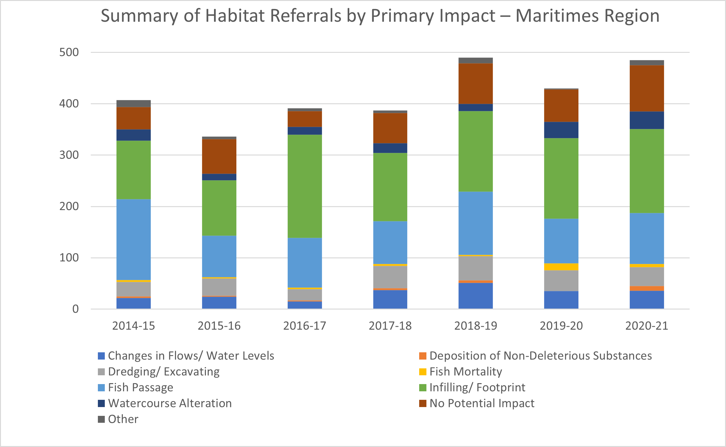
Referrals are requests for review or applications for Fisheries Act authorizations, submitted to DFO either directly by a proponent or indirectly by a consultant, the Province, or other agency concerning proposed works, undertakings, and/or activities (WUA) that may affect fish or fish habitat. The graph below provides a summary of the referrals received in Maritimes Region by primary impact.
Summary of Habitat Referrals by Primary Impact – Maritimes Region - Text version
| Year | Changes in Flows/ Water Levels | Deposition of Non-Deleterious Substances | Dredging/ Excavating | Fish Mortality | Fish Passage | Infilling/ Footprint | Watercourse Alteration | No Potential Impact | Other | Total |
|---|---|---|---|---|---|---|---|---|---|---|
| 2014-15 | 22 | 3 | 28 | 4 | 157 | 114 | 22 | 44 | 13 | 407 |
| 2015-16 | 24 | 2 | 34 | 2 | 81 | 108 | 13 | 67 | 5 | 336 |
| 2016-17 | 15 | 2 | 22 | 3 | 97 | 201 | 15 | 31 | 5 | 391 |
| 2017-18 | 37 | 4 | 43 | 4 | 83 | 133 | 19 | 59 | 5 | 387 |
| 2018-19 | 51 | 5 | 47 | 3 | 123 | 157 | 14 | 79 | 11 | 490 |
| 2019-20 | 35 | 0 | 41 | 13 | 87 | 157 | 32 | 63 | 2 | 430 |
| 2020-21 | 36 | 9 | 37 | 6 | 99 | 164 | 34 | 90 | 10 | 485 |
Referrals may result in DFO providing a Letter of Advice to proponents or issuing an authorization or other Ministerial tool under the Fisheries Act as shown in the figure below. DFO also provides written advice to federal agencies, provincial/territorial/other agencies, technical expertise to environmental or impact assessment processes, and suggested mitigation measures provided to permitting agencies.
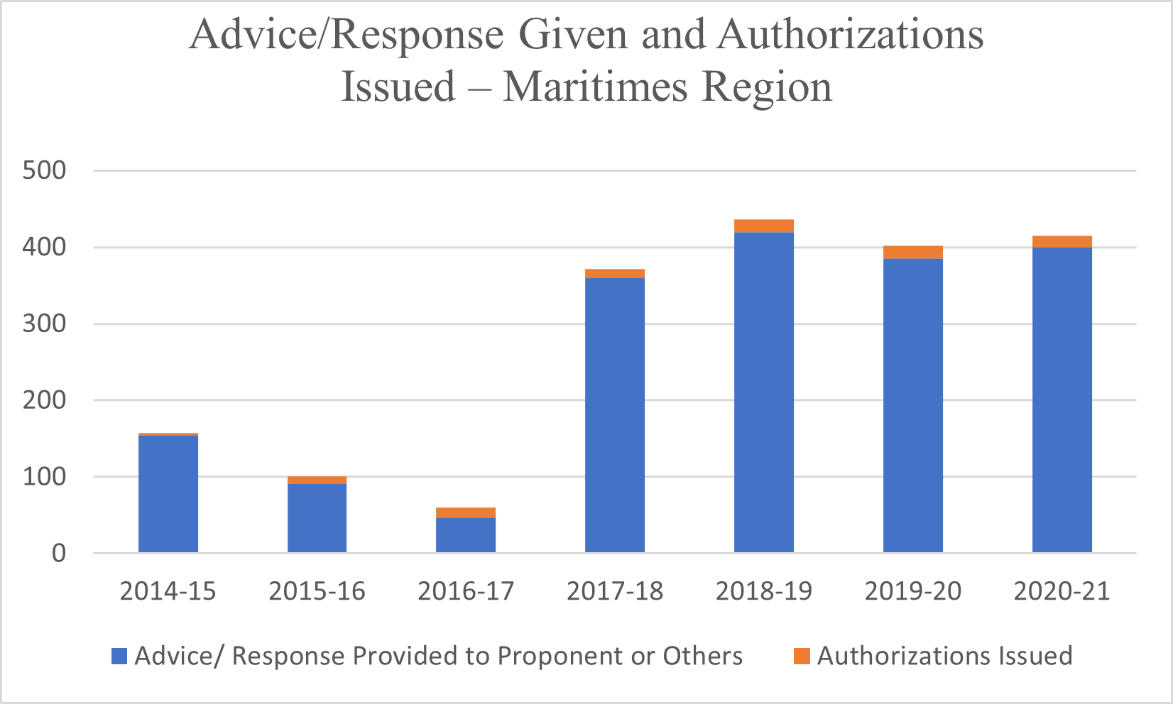
Advice/Response Given and Authorizations Issued – Maritimes Region - Text version
| Year | Advice/ Response Provided to Proponent or Others | Authorizations Issued | Total |
|---|---|---|---|
| 2014-15 | 155 | 2 | 157 |
| 2015-16 | 92 | 9 | 101 |
| 2016-17 | 47 | 13 | 60 |
| 2017-18 | 360 | 11 | 371 |
| 2018-19 | 420 | 16 | 436 |
| 2019-20 | 385 | 17 | 402 |
| 2020-21 | 400 | 15 | 415 |
Before approving any WUAs that will result in the death of fish and/or the harmful alteration, disruption, or destruction (HADD) of fish habitat, DFO must consider measures to offset any residual effects after avoidance and mitigation measures are applied. Offset measures are typically applied in two ways: through a specific habitat offsetting project or through fish habitat banks. A fish habitat bank is a formalized approach to offset, in advance, the potential HADD of fish and fish habitat from future authorized WUAs. In the Maritimes Region, habitat banks have been in place since the early 2000s and over 20 habitat banks have been created to offset authorized projects in marine and freshwater environments. Through these habitat banks, over 1.5 million m2 of fish habitat has been enhanced, restored, or created in Nova Scotia.
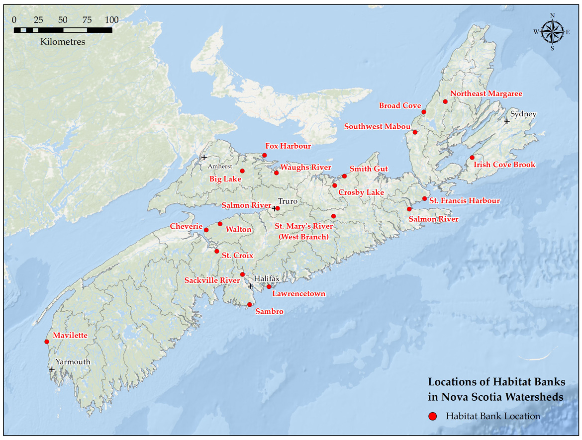
Fish habitat banks in Nova Scotia - Text version and data sources
Habitat banks are found in: Northeast Margaree, Broad Cove, Southwest Mabou, Irish Cove Brook, St. Francis Harbour, Salmon River, Smith Gut, Crosby Lake, Waughs River, Fox Harbour, Big Lake, Salmon River, St. Mary’s River (West Branch), Walton, Cheverie, St. Croix, Sackville River, Lawrencetown, Sambro, and Mavilette.
Data sources for base map
General Bathymetric Chart of the Oceans GEBCO_08 Grid, National Oceanic and Atmospheric Administration, National Geographic, Garmin, HERE, Geonames.org, and Esri.
Cheverie Creek fish habitat bank

The Cheverie Creek habitat bank is a joint project between the Nova Scotia Department of Public Works (formerly Transportation and Infrastructure Renewal) and DFO’s Small Craft Harbours (SCH) Branch. The project was designed to restore a more natural tidal regime to the tidally restricted salt marsh and river system through the replacement of an under-sized box culvert with a much larger elliptical-shaped structure designed to improve tidal flow and fish passage to the river. Following the culvert replacement, extensive annual monitoring has been conducted which confirmed the successful restoration of tidal flows. Tidal flooding increased in extent, duration, and frequency, improving wetland conditions, and the availability and accessibility of the marsh surface for fish. Overall, more than 35 hectares of wetland habitat were restored. The Province and DFO-SCH have been able to draw credits from the habitat bank to offset fish habitat impacts resulting from infrastructure projects such as twinning highways, installation of a breakwater, and dredging operations.
Partnerships
Collaborations with Indigenous organizations and communities, provincial government, and partners and stakeholders support knowledge sharing and the identification of fish and fish habitat conservation, protection, and restoration priorities, as well as the implementation of actions to address threats to fish and fish habitat.
DFO works closely with the Province of Nova Scotia to facilitate coordination of fish and fish habitat conservation and protection, including coordination of respective federal and provincial regulatory responsibilities, as described above.
The Nova Scotia Salmon Association (NSSA) is a key partner in conserving and protecting fish and fish habitat. The NSSA is the regional council of the Atlantic Salmon Federation and represents more than 25 local river associations. The NSSA’s Adopt a Stream program helps community groups improve the quality of aquatic habitat for fish and other wildlife in and around the waterways of Nova Scotia. The program provides technical support to local river associations and community groups to undertake projects to restore aquatic and riparian habitat, including providing training, data gathering assistance, and project resources. This video describes the work of the Adopt a Stream program.
Funding programs
DFO administers several funding programs that contribute to the conservation, protection, and restoration of fish habitat including the:
- Recreational Fisheries Conservation Partnerships Program (RFCPP) ran from 2013-2019 with the goal of enhancing the sustainability and ongoing productivity of recreational fisheries. Over this time, more than $3.5 million in funding was provided to partners to restore, rebuild, and rehabilitate recreational fisheries habitat across 59 projects in Nova Scotia. These projects contributed to the restoration of over 5,000,000 m2 of fish habitat in the province
- Coastal Restoration Fund (CRF) ran from 2017-2022 with the objective of restoring coastal aquatic habitats. In Nova Scotia over $8.6 million in funding was provided to six projects that contributed to the restoration of important marine and coastal areas such as saltmarshes, as well as remediating barriers to fish passage at key freshwater and marine points
- Habitat Stewardship Program for Aquatic Species at Risk (HSP) contributes to the recovery of aquatic species at risk by engaging Canadians in conservation actions. Between 2018-19 and 2022-23, over $1.8 million in funding has been awarded to sixteen freshwater projects in Nova Scotia, including projects to restore fish habitat and remediate barriers to fish passage
- Canada Nature Fund for Aquatic Species at Risk (CNFASAR) was established to provide funding to stewardship projects that support the recovery and protection of aquatic species at risk, specifically focused on priority threats, species, and places. Between 2019-20 and 2022-23, over $7.3 million in funding has been awarded to five freshwater projects in Nova Scotia supporting improvements to fish passage, fish habitat, and water quality
- Indigenous Habitat Participation Program (IHPP) launched in 2019 to support opportunities for Indigenous communities to participate in the conservation and protection of fish and fish habitat. Funding is available to support Indigenous peoples participation in consultation related to fish and fish habitat conservation and protection under the Fisheries Act or SARA; participation in engagement on the development of fish and fish habitat conservation and protection policies, regulations, and programs; and collaborative activities such as planning, protection, monitoring, and conservation of fish and fish habitat
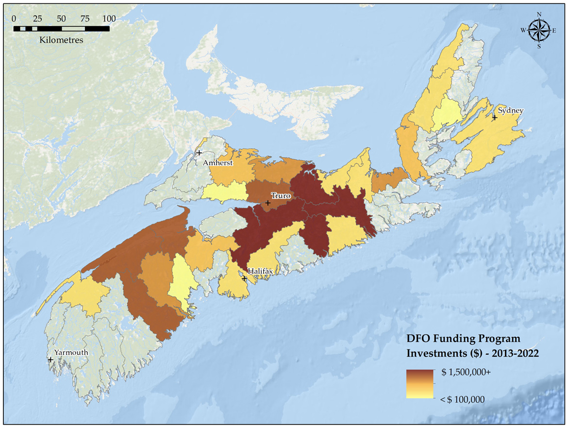
DFO funding program investments in Nova Scotia - Text version and data sources
Mapping of restoration projects funded through various Grants and Contributions (G&C) programs was completed using the primary watershed scale. Contribution funding has been invested in watersheds across Nova Scotia, aligning with the different priorities and objectives of the different programs. The mapping represents the total investments made under the Recreational Fisheries Conservation Partnerships Program (2013-2019), the Coastal Restoration Fund (2017-2022), the Habitat Stewardship Program (2018-2022), and the Canada Nature Fund for Aquatic Species at Risk (2019-2022).
While most funded projects were focused on restoration in a single watershed, a select few projects completed restoration work in multiple primary watersheds. In these cases, the total funding associated with each project was spread evenly across each of the watersheds in which the restoration work took place. The final map product provides a visual depiction of the geographic spread of restoration funding across the different primary watersheds.
| Primary Watershed | Total Contribution ($) Amount (2013-2022) |
|---|---|
| Annapolis | $1,058,715 |
| Barrington / Clyde | - |
| Cheticamp River | $247,500 |
| Clam Harbour / St. Francis | - |
| Country Harbour | - |
| East / Indian River | - |
| East / Middle / West (Pictou) | $2,116,134 |
| East / West (Sheet Harbour) | $1,771,944 |
| Economy | $60,520 |
| French | $461,435 |
| Gaspereau | $1,070,244 |
| Gold | $25,000 |
| Grand | - |
| Herring Cove / Medway | $1,266,245 |
| Indian | - |
| Isle Madame | - |
| Kelly / Maccan / Hebert | - |
| Kennetcook | - |
| LaHave | $815,984 |
| Liscomb | $364,561 |
| Margaree | $433,144 |
| Mersey | - |
| Meteghan | - |
| Missaguash | $490,895 |
| Musquodoboit | $364,561 |
| New Harbour / Salmon | - |
| North / Baddeck / Middle | $58,300 |
| Parrsboro | - |
| Philip / Wallace | $577,064 |
| River Denys / Big | - |
| River Inhabitants | $539,998 |
| River John | $821,553 |
| Roseway / Sable / Jordan | - |
| Sackville | $217,918 |
| Salmon / Debert | $1,330,810 |
| Salmon / Mira | $331,012 |
| Shubenacadie / Stewiacke | $1,977,963 |
| Sissiboo / Bear | $147,180 |
| South / West | $370,572 |
| St. Croix | $577,064 |
| St. Mary’s | $1,911,811 |
| Tangier | - |
| Tidnish / Shinimicas | - |
| Tracadie | $882,225 |
| Tusket River | - |
| Wreck Cove | - |
Data sources for base map
General Bathymetric Chart of the Oceans GEBCO_08 Grid, National Oceanic and Atmospheric Administration, National Geographic, Garmin, HERE, Geonames.org, and Esri.
Contribution funding has been invested in watersheds across Nova Scotia, aligning with the different priorities and objectives of the different programs. The map below shows investments made under the Recreational Fisheries Conservation Partnerships Program (2013-2019), the Coastal Restoration Fund (2017-2022), the Habitat Stewardship Program (2018-2022), and the Canada Nature Fund for Aquatic Species at Risk (2019-2022).
Watershed planning
Watershed plans summarize the local state of fish habitat as well as identify priorities for local restoration efforts. Throughout Nova Scotia, the development of watershed plans has been led by many of DFO’s partners.
Nova Scotia Salmon Association W.A.T.E.R project
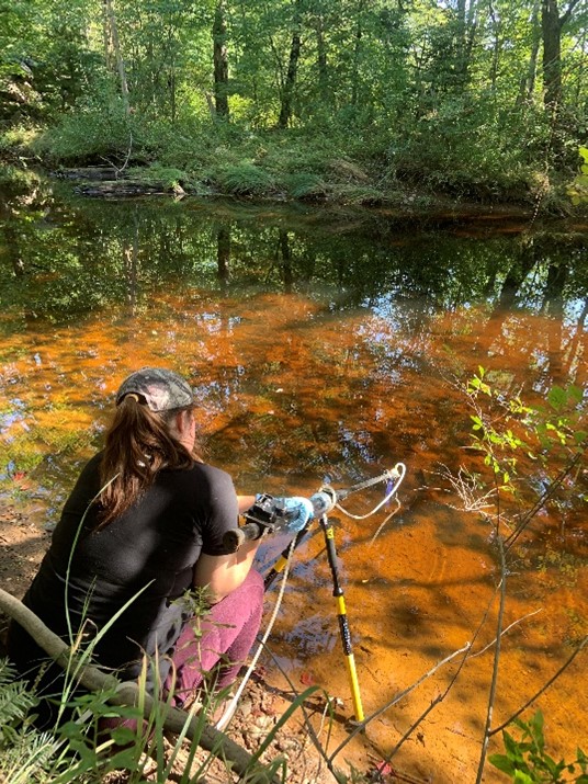
With funding from the Canada Nature Fund for Aquatic Species at Risk, the Nova Scotia Salmon Association (NSSA) is carrying out the W.A.T.E.R. (Watershed Assessments Towards Ecosystem Recovery) project in collaboration with local watershed groups and other partners. Through this project, the NSSA is developing watershed-level plans to guide restoration efforts to help improve the quality of aquatic habitat in eight priority watersheds: the Annapolis, Lahave, Medway, Mosher, Musquodoboit, Petite, St. Mary’s, and West River-Sheet Harbour watersheds. The project is making use of innovative tools, such as environmental DNA (eDNA), to map the distribution of species at risk and aquatic invasive species, and LiDAR-based mapping and remote sensing to build fully integrated freshwater habitat inventories. Water chemistry data is being collected to inform mitigation planning and modelling approaches are being used to identify critical cold-water habitats that build resiliency for climate change. Using well established tools for prioritization, assessment, and analysis, the plans will identify, detail, and rank pragmatic conservation actions for each watershed.
The Confederacy of Mainland Mi’kmaq Indigenous Knowledge in support of planning
The Confederacy of Mainland Mi’kmaq’s (CMM) Mi’kmaw Conservation Group (MCG) is carrying out a collaborative approach to watershed planning and management for multiple areas across Nova Scotia: the St. Croix, Stewiacke, and West, Middle and East (Pictou) rivers. With funding from the Canada Nature Fund for Aquatic Species at Risk, the project is using a Two-Eyed Seeing approach to watershed management planning. The Two-Eyed Seeing approach allows for a greater understanding of the cultural importance of the watersheds to Mi’kmaw communities and increases the capacity of the MCG and participating Mi’kmaw communities to shape and participate in recovery actions and management of the watershed. Using Mi’kmaw Ecologic Knowledge (MEK), barrier assessments, habitat surveys, invasive species threat assessments, and remediation prioritization, watershed management plans are being developed to guide the improvement of habitat for multiple species at risk, specifically Atlantic salmon (Plamu’k), American eel (Katew), and Brook floater (Jipu’ji’jey N’kata’law). MEK is being used to guide habitat and species survey efforts and the information collected also assists with the prioritization of remediation efforts and management activities.
- Date modified: