
Book 2, Tab B6 - Marine planning and conservation
On this page
- Purpose
- Background
- Marine conservation
- Oceans Act MPA establishment and management process
- Project finance for permanence
- Marine environmental quality
- Marine spatial planning
- Decision making is informed by
- Annex A: Conserved areas
- Annex B: Federal Marine Conservation Tools
- Annex C: Map of Candidate PFPs in Canada
- Annex D: Bioregions where MSP has been advanced
Purpose
To provide an introductory overview of ministerial powers and responsibilities in four areas:
- Marine conservation
- Project Finance for Permanence
- Marine environmental quality
- Marine spatial planning
Background
- The Minister of Fisheries, Oceans and the Canadian Guard is the lead federal authority for ocean-related matters with a mandate to ensure the health, sustainability, and economic viability of Canada’s three oceans.
- This involves balancing conservation efforts with economic opportunities for coastal and Indigenous communities.
- Working with provinces, territories, and other federal departments (e.g., Transport Canada, Environment and Climate Change Canada) that have authorities and share responsibilities in the ocean and marine environment.
Domestic and International Commitments
- Domestically, Canada has committed to conserving 30% of our marine and coastal areas by 2030.
- Internationally these actions support efforts to meet Canada’s commitment to the Kunming-Montreal Global Biodiversity Framework to conserve 30 per cent of marine and coastal areas globally by 2030.
1. Marine Conservation
The Minister has the power to establish marine protected areas (under the Oceans Act) and marine refuges (under the Fisheries Act)
- Fisheries and Oceans Canada (DFO) creates long-term spatial protection for marine biodiversity through two primary mechanisms.
- Under the Oceans Act, the Minister recommends that the Governor-in-Council (GiC) establish marine protected areas (MPAs) through regulations.
- The Minister may also establish MPAs for up to five years through Ministerial Order (MO) regulations.
- Under the Fisheries Act, the Minister may establish:
- Marine refuges, which qualify as Other Effective Area-Based Conservation Measures (OECMs) and contribute to Canada’s marine conservation targets.
To date, Canada has protected 15.54% of its oceans.
Oceans Act MPA establishment and management process
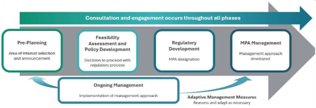
Long Description:
The diagram outlines a linear process for managing Marine Protected Areas (MPAs), divided into four sequential phases. A green arrow spans the top and bottom of the diagram, emphasizing that consultation and adaptive management measures are continuous across the entire process.
The four phases are:
Pre-Planning
- Activities include selecting and announcing the Area of Interest.
Feasibility Assessment and Policy Development
- This phase concludes with a decision on whether to proceed with the regulatory process.
Regulatory Development
- The MPA is officially designated during this stage.
MPA Management
- A management approach is developed to guide the protection and use of the MPA.
Consultation and engagement occurs throughout all phrases
- Pre-planning
- Area of interest selection and announcement
- Feasibility assessment and policy development
- Decision to proceed with regulatory process
- Regulatory development
- MPA designation
- MPA management
- Management approach developed
Ongoing management
- Implementation of management approach
Adaptive management measures
- Reassess and adapt as necessary
1. Project Finance for Permanence (PFP)
Project Finance for Permanence (PFP) is a conservation financing and implementation model that can be used to secure large-scale, long-term protection in the marine environment.
Supports Indigenous leadership in conservation
- Indigenous-led project model based on partnership between Indigenous organizations, governments & the philanthropic community.
Supports sustainable conservation
- Based on a unified vision for a conservation plan.
- Single deal moment ensures everything is in place for successful implementation.
Innovative financial model that
- Provides long-term funding for conservation projects, including marine areas.
- Disburses funds as conservation milestones are met.
- Incorporates private funds within the funding model.
Recent investments by the Government are supporting four PFP initiatives, in key areas across Canada, including the Great Bear Sea (Northern Shelf Bioregion) and Qikiqiktani Region (Nunanvut) led by DFO.
2. Marine Environmental Quality
Summary
- Under the Oceans Act, the Minister may establish marine environmental quality (MEQ) guidelines, objectives, criteria, standards and requirements respecting estuaries, coastal waters and marine waters.
- These MEQ management measures are to be established in collaboration with partners, including provinces, territories, Indigenous Peoples, and coastal communities.
- The non-regulatory tools (e.g., objectives, guidelines) may be established by the Minister and regulatory measures (e.g., standards, requirements) are implemented by the GiC, on the recommendation of the Minister.
- These integrated and evidenced-based tools and strategies can be developed to understand environmental stressors; evaluate existing management measures or strategies; and adjust existing measures and/or develop new ones.
Key priorities include:
- Minimizing the impacts of marine stressors such as ocean noise, marine debris, and nutrient enrichment on marine life.
- Supporting marine planning by developing management measures and providing advice.
- Supporting effective management of MPAs and marine refuges through acoustic monitoring, vessel slowdowns, and other initiatives.
Specific Commitments:
- Draft Ocean Noise Strategy public consultation closed on October 22, 2024. Final Strategy and Federal Action Plan to be published in 2025.
- The 2007 Statement of Canadian Practice with respect to the Mitigation of Seismic Sound in the Marine Environment is being reviewed and updated.
- A framework for the establishment and application of regulatory and non-regulatory MEQ measures is being developed.
3. Marine Spatial Planning
Summary
- Marine Spatial Planning (MSP) is an internationally recognized forward-looking and collaborative process that leverages data and knowledge to help us better understand and coordinate where, when, and how we use and manage the ocean and its resources to achieve ecological, economic, social, and cultural objectives.
- MSP enables Integrated Ocean Management (IOM) under s.31 of the Oceans Act as an important tool in supporting oceans-related priorities, including:
- Providing a mechanism to support Canada's ocean economy and clean growth agenda;
- Advancing collaborative relationships and governance structures with other federal organizations, provinces, territories and Indigenous Peoples; and,
- Enabling Canada to meet domestic and international commitments to marine conservation and protection.
Accomplishments from 2018-2024
- Publication of the Canada Marine Planning Atlas
- Publication of four first generation Marine Spatial Plans DFO’s National Guidance for MSP
- Cumulative Impacts Mapping for Pacific and Maritimes regions
Decision making is informed by
Science & Knowledge
Improve the collective understanding of oceans using integrated science and knowledge to support all processes (i.e., ecological and socio-economic data, Indigenous Knowledge, local stakeholder and community knowledge).
Standards
Protection standards for federal MPAs and OECMs.
Socio-economic and cultural considerations
Analysis of impacts of conservation decisions on marine resource users, stakeholders, and coastal communities. Analysis of data on diverse ocean topics for MSP processes.
Partner collaboration and stakeholder engagement
Collaborative governance with OGDs, Provinces/Territories and Indigenous Peoples.
Active participation of stakeholders (industry, environmental groups, and coastal communities).
Annex A: Conserved Areas
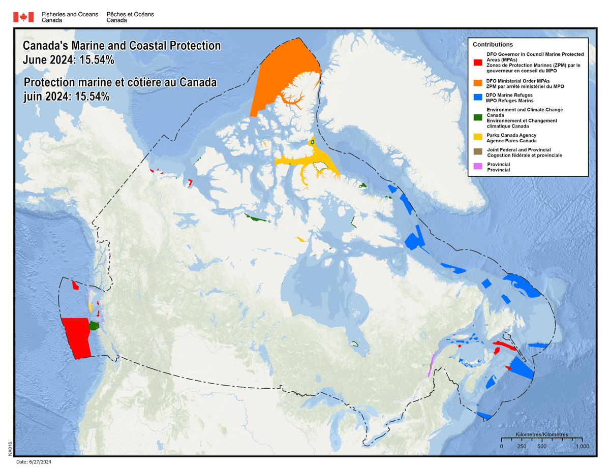
Long Description:
Map of Canada’s marine and coastal protection. June 2024: 15.54%.
Contributions
- DFO governor in council marine protected areas (MPAs)
- DFO ministerial orders MPAs
- DFO marine refuges
- Environment and Climate Change Canada
- Parks Canada Agency
- Joint federal and provincial
- Provincial
Annex B: Federal Marine Conservation Tools
Federal Marine Protected Areas (MPAs)
| Tool | Lead | Enabling Legislation | Time to Establish | Contributes to Marine Conservation Targets |
|---|---|---|---|---|
| Oceans Act MPAs (via GiC regulations) | Fisheries and Oceans Canada | Oceans Act | 5+ years | Yes |
| Oceans Act MPAs (via ministerial order) | Fisheries and Oceans Canada | Oceans Act – provides interim protection, freezes the footprint for up to 5 years | 3.5+ years | Yes |
| National Marine Conservation Areas | Parks Canada | Canada National Marine Conservation Areas Act | 5+ years | Yes |
| Marine National Wildlife Areas | Environment and Climate Change Canada | Canada Wildlife Act | 5+ years | Yes |
Other Effective Area-based Conservation Measures (OECMs)
“OECM” is a policy-based status applied to area-based measures that meet science-based criteria
| Tool | Lead | Enabling Legislation | Time to Establish | Contributes to Marine Conservation Targets |
|---|---|---|---|---|
| Marine refuge | Fisheries and Oceans Canada | Fisheries area closures established under the Fisheries Act that meet the OECM criteria
|
3 months to 6 years | Yes |
Annex C: Map of Candidate PFPs in Canada
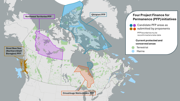
Long Description:
Map of Candidate Project Finance for Permanence (PFPs) initiatives in Canada alongside current protected and conserved areas. PFP boundaries may be reconfirmed at a later date. PFPs include:
- Great Bear Sea (Northern Shelf Bioregion) PFP
- Northwest Territories PFP
- SINAA PFP
- Omushkego Wahkohtowin PFP
Annex D: Bioregions where MSP has been advanced
The planning areas shown here, (star), include:
- Pacific North Coast
- Pacific South Coast
- Bay of Fundy/Scotian Shelf
- Newfoundland-Labrador Shelves
- Estuary and Gulf of St. Lawrence
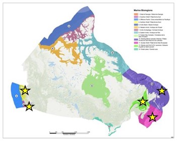
Long Description:
Marine bioregions
- Strait of Georgia
- Southern shelf
- Offshore pacific
- Northern shelf
- Artic basin
- Westshore artic
- Artic archipelago
- Eastern artic
- Hudson Bay complex
- Newfoundland-Labrador shelves
- Scotian shelf
- Estuary and Guld of St. Lawrence
- Great Lakes
Page details
- Date modified: