
The Scotian shelf: an atlas of human activities
Co-editors
Heather Breeze
Tracy Horsman
Maps
Tracy Horsman
Heather Breeze
Stanley K. Johnston
Layout and Design
Francis Kelly
Writers
Heather Breeze
Scott Coffen-Smout
Derek Fenton
Tim Hall
Glen Herbert
Tracy Horsman
Paul Macnab
David Millar
Peter Strain
Philip Yeats
All rights reserved. No part of this information (publication or product) may be reproduced or transmitted in any form or by any means, electronic, mechanical, photocopying, recording or otherwise, or stored in a retrieval system, without prior written permission of the Minister of Public Works and Government Services Canada, Ottawa, Ontario, Canada K1A 0S5 or at Copyright.Droitdauteur@communication.gc.ca.
- Cat. No.
- Fs23-483-2005
Fs23-483/2005-PDF
Fs23-483/2005E-HTML - ISBN
- 0-662-69160-1
0-662-69170-9 (PDF)
0-662-40952-3 (HTML) - URL
- Fisheries and Oceans Canada
Published by:
Oceans and Coastal Management Division
Oceans and Habitat Branch
Fisheries and Oceans Canada, Maritimes Region
P.O. Box 1006
Dartmouth, NS B2Y 4A2
fax: (902) 426-3855
e-mail: essim@mar.dfo-mpo.gc.ca
DFO/2005-816
© Her Majesty the Queen in Right of Canada, 2005
Table of Contents
- Acknowledgements
- Introduction
- Reference Maps
- Jurisdictional and Political Boundaries
- Fisheries
- Introduction
- Fisheries Management Areas
- Groundfish Landings (1999-2003)
- Groundfish Landings by Gear Type (1999-2003)
- Seasonal Groundfish Landings (1999-2003)
- Cod, Haddock and Pollock Landings (1999-2003)
- Flatfish Landings (1999-2003)
- Halibut Landings (1999-2003)
- Redfish Landings (1999-2003)
- Silver Hake Landings (1999-2003)
- Herring Landings (1999-2003)
- Mackerel Landings (1999-2003)
- Bluefin Tuna Landings (1999-2003)
- Landings of Large Pelagic Species (1999-2003)
- Swordfish Landings (1999-2003)
- Albacore, Bigeye and Yellowfin Tuna Landings (1999-2003)
- Porbeagle, Mako and Blue Shark Landings (1999-2003)
- Crab Landings (All Species) (1999-2003)
- Snow Crab Landings (1999-2003)
- Crab Landings (Except Snow Crab) (1999-2003)
- Scallop Landings (1999-2003)
- Scallop Landings by Season (1999-2003)
- Offshore Clam Landings (1999-2003)
- Shrimp Landings (1999-2003)
- Offshore Lobster Landings (1999-2003)
- Special Management Areas
- Marine Traffic
- Oil And Gas Industry
- Other Activities
- Ocean Disposal And Marine Environmental Quality
Jurisdictional and Political Boundaries
Canada’s Maritime Zones
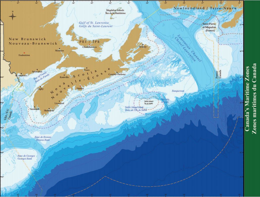
Canada’s Maritime Zones
Legend: Canada’s Maritime Zones
Canada’s Oceans Act claims four maritime zones consistent with international law and practice and in accordance with the United Nations Convention on the Law of the Sea. Canada’s jurisdiction over ocean space is recognized through the declaration of the territorial sea, the contiguous zone, the exclusive economic zone (EEZ), and the continental shelf. The Oceans Act also defines areas known as fishing zones, two of which are found on the Atlantic coast.
Extending 12 nautical miles (NM) from the baselines, the territorial sea extends full sovereignty over the sea, airspace, seabed and subsoil. The contiguous zone extends 12 NM beyond the outer edge of the territorial sea and grants rights and responsibilities to prevent infringement of Canada’s customs, fiscal, sanitary, and immigration laws and regulations. In the 200-NM EEZ, Canada has sovereign rights and responsibilities with respect to the exploration and exploitation of living and non-living resources of the water column, seabed and subsoil. The EEZ also provides Canada with the responsibility and jurisdiction to protect the marine environment, to regulate scientific research, and to control offshore installations and structures. The continental shelf includes the seabed and subsoil and extends from the territorial sea to the outer edge of the continental margin or to 200 NM, from the baselines of the territorial sea, if this distance is greater. On the continental shelf, Canada may exercise its rights and responsibilities with respect to the exploration and exploitation of non-living mineral resources and sedentary species (e.g., clams) beyond the EEZ limit.
Fishing Zones 1 (the Gulf of St. Lawrence) and 2 (the Bay of Fundy) were created before the concept of the EEZ was broadly accepted in international law. In the early 1970s, Canada established closing lines for the Gulf of St. Lawrence and Bay of Fundy and claimed these areas as exclusive fishing areas.
The US-Canada maritime boundary in the Gulf of Maine at Machias Seal Island, a small, rocky mound at the mouth of the Bay of Fundy, has never been officially delimited due to the disputed sovereignty of the island. This issue was not resolved during the arbitration of the Georges Bank boundary in 1984, and as a result, both Canada and the United States claim approximately 259 square kilometres of fishing grounds around the island.
The ESSIM Planning Area
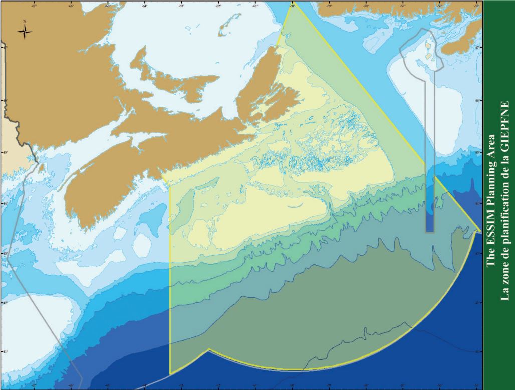
The ESSIM Planning Area

Legend: The ESSIM Planning Area
Canada’s Oceans Act gives the Minister of Fisheries and Oceans the responsibility to lead and facilitate integrated management for Canada’s oceans. The Eastern Scotian Shelf Integrated Management (ESSIM) initiative is a collaborative ocean planning process being led by Fisheries and Oceans Canada (DFO), Maritimes Region. Its primary goal is to develop an integrated ocean management plan for the ESSIM Planning Area. The Planning Area encompasses an approximately 325,000-square-kilometre portion of the Scotian Shelf and was delineated using existing administrative boundaries. The western boundary is defined by the Northwest Atlantic Fisheries Organization (NAFO) 4WX line that runs between LaHave Basin and Emerald Basin; the eastern boundary is the NAFO 4V/3PS line running through the Laurentian Channel and into the Gulf of St. Lawrence. This line also forms the eastern boundary for DFO’s Maritimes Region. More information about the NAFO areas can be found with the “Fisheries Management Areas” map and accompanying text.
Although the ESSIM initiative is addressing ocean uses that occur both offshore and in coastal waters, the focus of the initial ESSIM plan is the offshore, from the outer limit of the 12-nautical-mile territorial sea to the seaward extent of Canadian jurisdiction. This area was selected for integrated management because it possesses important living and non-living marine resources, areas of high biological diversity and productivity, and increasing levels of multiple use and competition for ocean space and resources.
- Date modified: