
Canada’s Oceans Now: Atlantic Ecosystems, 2022 - Sea Ice is changing, impacting habitats and food webs
Text version
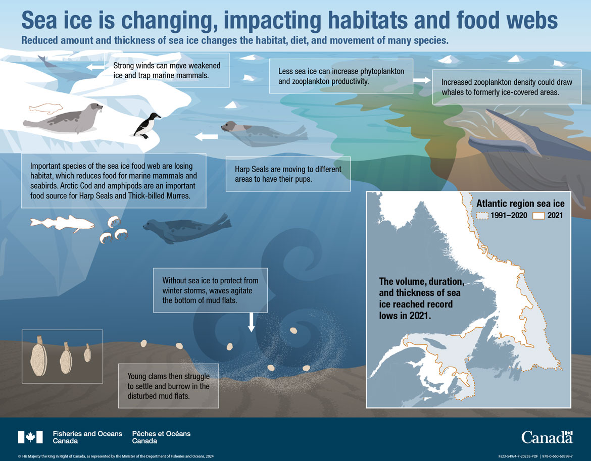
Sea Ice is changing, impacting habitats and food webs
Reduced amount and thickness of sea ice changes the habitat, diet, and movement of many species.
This infographic shows a simplified sea ice environment from the ocean surface with ice floes to the bottom which is a rippled grey-brown sand.
At top left of the illustration a white shaded, transparent box with a white arrow points at a whale diving between the ice floes.
- Strong winds can move weakened ice and trap marine mammals.
A Harp Seal is on the ice with an orange dotted line outlining a Harp Seal which is not there. A Thick-billed Murre is also resting near the edge of the ice. Below the ice in the water, the orange dotted lines represent a missing Arctic Cod and amphipods and a Harp Seal is swimming towards them. There is a text box in the middle of the illustrations:
- Important species of the sea ice food web are losing habitat, which reduces food for marine mammals and seabirds.
- Arctic Cod and amphipods are an important food source for Harp Seals and Thick-billed Murres.
To the right of the ice, another Harp Seal is swimming in the water coming towards the ice. There is a white arrow pointing to the left, and underneath is a text box:
- Harp Seals are moving to different areas to have their pups.
Towards the bottom left of the infographic there are three clams surrounded by a white box outline. To the right, four small young clams are being displaced by a strong underwater ocean current. Two white text boxes are next to the illustrations:
- Without sea ice to protect from winter storms, waves agitate the bottom of mud flats.
- Young clams then struggle to settle and burrow in the disturbed mud flats.
At top right at the surface of the water, there is a green phytoplankton bloom and to its right a greenish-brown zooplankton bloom. A Humpback Whale is feeding on the zooplankton. Two white text boxes are next to the illustrations:
- Less sea ice can increase phytoplankton and zooplankton productivity.
- Increased zooplankton density could draw whales to formerly ice-covered areas.
On the bottom right of the infographic is a white box with a map of the Canadian Atlantic region illustrating difference in sea ice extent between 2021 and the average for 1991 to 2020. The extent for 1991 to 2020 average is outlined by orange dashed lines and 2021 extent is outlined by solid orange lines. Sea ice for the 1991 to 2020 period on average extended almost to the south of the island of Newfoundland, throughout the Gulf of St. Lawrence and the northern Scotian Shelf. In 2021 The extent was less, only reaching the northern portions of the island of Newfoundland, and the bottom half of the Gulf of St. Lawrence with little ice in the Scotian Shelf bioregion.
Map Title: Atlantic region sea ice
Text on the map: The volume, duration, and thickness of sea ice reached record lows in 2021.
Related links
- Date modified: