
Canada’s Oceans Now: Atlantic Ecosystems, 2022 - New findings on whale habitat
Text version
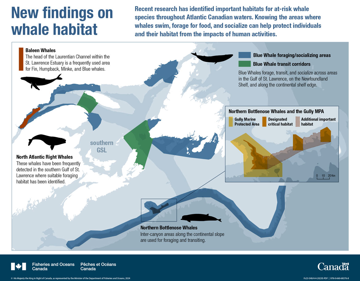
New findings on whale habitat
This infographic illustrates a map of identified important habitats for at risk whale species throughout Atlantic Canadian waters. The map covers the Scotian Shelf, Gulf and Estuary of St. Lawrence , southern Labrador and the island of Newfoundland.
Blue text at the top right of the infographic: Recent research has identified important habitats for at-risk whale species throughout Atlantic Canadian waters. Knowing the areas where whales swim, forage for food, and socialize can help protect individuals and their habitat from the impacts of human activities.
At the top left of the map an black outline of a Humpback Whale is underneath black text:
Baleen Whales
- The head of the Laurentian Channel within the St. Lawrence Estuary is a frequently used area for Fin, Humpback, Minke, and Blue Whales
At the top right of the map, a black outline of a Blue Whale is next to a legend that shows that Blue Whale foraging/socializing areas and Blue Whale transit corridors are illustrated in blue and green respectively. In black text below the legend:
Blue Whales forage, transit, and socialize across areas in the Gulf of St. Lawrence, on the Newfoundland Shelf and along the continental shelf edge
There are six Blue Whale foraging/socializing areas outlined on the map:
- A strip along the edge of the continental shelf from the southern Scotian Shelf to the Grand Banks of Newfoundland and Labrador.
- An area around the southern coast of the island of Newfoundland.
- A small area on the southern edge of the west coast of the island of Newfoundland.
- An area in the Strait of Belle Isle between Labrador and the island of Newfoundland.
- Along the north and south coasts of the Estuary of St. Lawrence.
- At the end of the Gaspe Peninsula into the southern Gulf of St. Lawrence.
There are two Blue Whale transit corridors outlined on the map:
- An area within the Gulf of St. Lawrence underneath Anticosti Island to the opposite shore.
- An area between Cape Breton, NS and the southwest of the Island of Newfoundland.
On the land to the middle left of the map there is a black outline of a North Atlantic Right Whale with black text underneath:
North Atlantic Right Whales
- These whales have been frequently detected in the southern Gulf of St. Lawrence where suitable foraging habitat has been identified.
To the bottom of the map, under the edge of the continental shelf, a Northern Bottlenose Whale is illustrated in a black outline. Black text underneath:
- Northern Bottlenose Whales
Inter-canyon areas along the continental slope are used for foraging and transiting
An area of the shelf edge the Gully Marine Protected Area is surrounded by a black box outline and an enlarged map of this area is shown to the right. Within this box there is a legend with each area given in a different colour:
Northern Bottlenose Whales and the Gully MPA
- Gully Marine Protected Area (yellow)
- Critical habitat (red)
- Additional important habitat (lighter red)
The Gully MPA is a larger area to the left of the map, and there are three areas of designated critical habitat which go from left to right across the map. The area of additional important habitat runs left to right along the shelf edge connecting the other areas.
Related links
- Date modified: