
British Columbia Marine/Estuarine Timing Windows for the Protection of Fish and Fish Habitat - South Coast and Lower Fraser Areas
[ North Coast Area ]
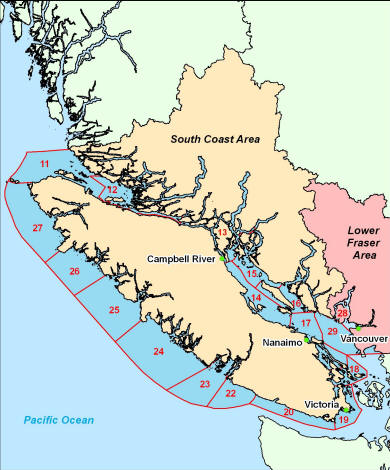
South Coast and Lower Fraser Areas
- Area 11 - Port Hardy
- Area 12 - Alert Bay
- Area 13 - Campbell River/Sayward
- Area 14 - Comox/Qualicum
- Area 15 - Powell River
- Area 16 - Pender Harbour
- Area 17 - Nanaimo
- Area 18 - Cowichan
- Area 19 - Victoria
- Area 20 - Sooke
- Area 22 - Nitinat
- Area 23 - Port Alberni
- Area 24 - Tofino
- Area 25 - Tahsis
- Area 26 - Kyoquot
- Area 27 - Quatsino Sound
- Area 28 - Vancouver
- Area 29 - Steveston/Surrey
Area 11 - Port Hardy
This area includes the coastline of the mainland of B.C. between Akam Point (excluded) and Silvester Bay (excluded) and the coast of Vancouver Island from Nels Bight (excluded) to Robson Bight (excluded) including all the open water area of the Queen Charlotte Strait between those points. This area does not include any islands in the Queen Charlotte Strait and Johnstone Strait east of Akam Point. All the open water more than 1 km away from the western shore (Vancouver Island) of the Johnstone Strait is excluded from the area.
The following are time periods when the timing windows of least risk are open.
Summer Window: July 1 - August 15
- Seymour River Estuary: July 1 - July 15
Summer windows do not apply in any of the following estuaries: Shushartie River, Nimpkish River, and Quatse River.
Winter Window: November 15 - February 15
Area 12 - Alert Bay
This area includes the coast of mainland B.C. between Shaw Point (included) and Akam Point (included) and all islands and open water in the Queen Charlotte Strait and Johnstone Strait west of Shaw Point and east of Akam Point and the part of Bradwicke Island west of Shaw Point. Area 12 does not include open water within 1 km from the shore of Vancouver Island.
The following are time periods when the timing windows of least risk are open.
Summer Window: July 1 - August 15
- Embley Creek Estuary: July 1 – July 15
Summer windows do not apply in any of the following estuaries: Ahnuhati River, Fulmore River, Kakweiken River, Kingcome River, Klinaklini River, Mackenzie Snd. Creek, Protection Pt. Creek, Sim River, and Wakeman River.
Winter Window: November 15 - February 15
Area 13E - Campbell River
This area includes the coast of mainland B.C. between Pryce Channel / Sutil Channel (included) and Shaw Point (excluded) as well as the coast of Vancouver Island between Discovery Passage southern end (included) and Camp Point (included) and all islands and open water between these points. The area also includes Bute Inlet, Loughborough Inlet, and the part of Bradwicke Island east of Shaw Point.
The following are time periods when the timing windows of least risk are open.
Summer Window: July 1 - September 1
- Amor de Cosmos Creek Estuary: July 1 - July 15
Summer windows do not apply in any of the following estuaries: Apple River, Campbell River, Heydon Creek, Homalthko River, Phillips River, Stafford River, and Village Bay Creek.
Winter Window: November 1 - February 15
Area 13W - Sayward
This area includes the coast of Vancouver Island between Camp Point (excluded) and Robson Bight (excluded). It does not include any open water more than 1 km away from the shore.
The following are time periods when the timing windows of least risk are open.
Summer Window: July 1 - September 1
Summer windows do not apply in the following estuary: Eve River.
Winter Window: November 1 - February 15
Area 14N - Comox
This area includes the coast of Vancouver Island from Deep Bay (Mapleguard Point included) to the southern end of Discovery Passage (excluded). It also includes Denman and Hornby Island and extends into the open water of the Strait of Georgia to approximately the halfway point between Vancouver Island and the Mainland.
The following are time periods when the timing windows of least risk are open.
Summer Window: June 1 - September 1
- Oyster River Estuary: July 1 - July 15
- Puntledge/Courtney River Estuary: August 1 - August 10
- Trent River Estuary: July 1 - August 1
- Tsable River Estuary: July 1 - August 1
Winter Window: December 1 - February 15
Area 14S - Qualicum
This area includes the coast of Vancouver Island from Cottam Point (included) to Deep Bay (Mapleguard Point excluded). This area also includes Southwest Lasqueti Island from Jelina Island to Young Point. It does not include Northwest Bay. The area extends into the open water of the Strait of Georgia to approximately the halfway point between Vancouver Island and the Mainland.
The following are time periods when the timing windows of least risk are open.
Summer Window: June 1 - September 1
- Qualicum River Estuary: July 1 - August 1
- Englishman River Estuary: July 1 - August 1
Summer windows do not apply in the following estuary: Little Qualicum River.
Winter Window: December 1 - February 15
Area 15 - Powell River
This area includes the coast of the mainland of B.C. from Frolander Bay (excluded) to Toba Inlet (included). This area also includes Redonda Island and most of Cortes Island. It does not include the Pryce Channel, the Sutil Channel and adjacent coast of Cortes Island. The area extends into the open water of the Strait of Georgia to approximately the halfway point between Vancouver Island and the Mainland.
The following are time periods when the timing windows of least risk are open.
Summer Window: July 1 - September 1
- Brem River Estuary: July 1 - August 1
- Theodosia River Estuary: July 1 - August 1
- Toba River Estuary: July 1 - August 1
- Whittal Creek Estuary: July 1 - August 1
Summer windows do not apply in either of the following estuaries: Klite River and Lang Creek.
Winter Window: December 1 - February 15
Area 16 - Pender Harbour
This area includes the coastline of the mainland of B.C. from the Trail Islands (excluded) to Frolander Bay (included). It also includes Jervis Inlet, Texada Island and Northeast Lasqueti Island from Jelina Island to Young Point. The area extends into the open water of the Strait of Georgia to approximately the halfway point between Vancouver Island and the Mainland.
The following are time periods when the timing windows of least risk are open.
Summer Window: July 1 - September 1
- Cranby Creek Estuary: July 1 - August 1
- Dorsiton Creek Estuary: July 1 - August 1
- Lang Creek Estuary: July 1 - August 1
- McNair Creek Estuary: July 1 - July 15
- Mill Creek Estuary: July 1 - August 1
- Potlatch Creek Estuary: July 1 - August 1
- Rainy River Estuary: July 1 - July 15
Summer windows do not apply in any of the following estuaries: Angus Creek, Brittain Creek, Jefferd Creek, and Skwawka River.
Winter Window: December 1 - February 15
Area 17 - Nanaimo
This area includes the coast of Vancouver Island between Grave Point (excluded) and Cottam Point (excluded). It includes all the open water and all islands within an area that extends north to Lasqueti Island, east to the Trail Islands (included) and south to Sturdies Bay on Galiano Island (included). The area also includes Northwest Bay, partially includes parts of the Gulf Islands geographically north of Sturdies Bay, and includes the south-eastern tip of Lasqueti Island from Young Point to Squitty Bay.
The following are time periods when the timing windows of least risk are open.
Summer Window: June 1 - September 1
- Chemainus River and Bonsall Creek Estuary: July 1 - July 15
- Knarston Creek Estuary: July 1 - September 1
Summer windows do not apply in the following estuary: Nanaimo River.
Winter Window: December 1 - February 15
Area 18 - Cowichan
This area includes the coast of Vancouver Island from Swartz Bay (included) to Grave Point (included). It also includes all of the Gulf Islands south of Sturdies Bay on Galiano Island (excluded) but excludes the portion of Saltspring Island north of Swartz Bay, and the portion of Galiano Island north of Sturdies Bay. The area also extends east into open water 2 km past the easternmost tip of the Gulf Islands. The area excludes the part of Saanich Inlet south of Hatchet Point.
The following are time periods when the timing windows of least risk are open.
Summer Window: July 1 - October 1
Summer windows do not apply in the following estuary: Cowichan/Koksilah.
Winter Window: December 1 - February 15
Area 19 - Victoria
This area includes the coastline of Vancouver Island from Race Passage (included) to Swartz Bay (excluded). It also includes the part of Saanich Inlet south of Hatchet Point and extends into open water to the east and the south to the approximate halfway point between Vancouver Island and the United States.
The following are time periods when the timing windows of least risk are open.
Summer Window: July 1 - October 1
Summer windows do not apply in the following estuary: Durrance Creek.
Winter Window: December 1 - February 15
Area 20 - Sooke
This area includes the coast of Vancouver Island from Race Passage (excluded) to Carmanah Point (included). It extends south into open water to approximately halfway across the Strait of Juan de Fuca.
The following are time periods when the timing windows of least risk are open.
Summer Window: July 1 - October 1
- Gordon River Estuary: July 1 - August 1
- San Juan River Estuary: July 1 - July 15
- Sooke River Estuary: July 1 - August 15
Winter Window: December 1 - February 15
Area 22 - Nitinat
This area includes the coast of Vancouver Island from Carmanah Point (excluded) to Mills Peninsula (excluded). The area includes Bamfield Inlet and open water that extends out from the coast.
The following are time periods when the timing windows of least risk are open.
Summer Window: N/A
Winter Window: November 15 - February 15
Area 23 - Port Alberni
This area includes the coast of Vancouver Island from Mills Peninsula (included) to Macoah Passage (excluded). This area excludes Bamfield Inlet, and includes open water that extends out from the coast.
The following are time periods when the timing windows of least risk are open.
Summer Window: July 1 - September 1
- China Creek Estuary: July 1 - August 15
- Ritherdon Creek Estuary: July 1 - August 15
- Ward Creek Estuary: July 1 - August 15
Summer windows do not apply in either of the following estuaries: Coeur D'Alena Creek and Useless Creek.
Winter Window: November 15 - February 15
Area 24 - Tofino
This area includes the coast of Vancouver Island from Macoah Passage (included) to Hesquiat Peninsula (Estevan Point included). This area extends out into open water from the coast.
The following are time periods when the timing windows of least risk are open.
Summer Window: July 1 - September 1
- Bedwell River Estuary: July 1 - August 1
- Hootla Kootla River: July 1 - August 1
- Hotsprings River Estuary: July 1 - August 1
- Moyhea River Estuary: July 1 - August 1
- Sydney River Estuary: July 1 - August 1
- Tranquil Creek Estuary: July 1 - August 1
Summer windows do not apply in any of the following estuaries: Cypre River, Lower Kenedy River, Megin Creek, and Watta River.
Winter Window: December 1 - February 15
Area 25 - Tahsis
This area includes the coast of Vancouver Island from Hesquiat Peninsula (Estevan Point excluded) to Yellow Bluff (included). This area extends out into open water from the coast.
The following are time periods when the timing windows of least risk are open.
Summer Window: July 1 - August 15
Summer windows do not apply in any of the following estuaries: Gold River, Kleeptee Creek, Leiner Creek, Moovah Bay Creek, Owossitsa Creek, Park River, Pt. Elisa Creek #1 and 2, Sucwoa River, Tahsis River, and Tlupana River.
Winter Window: December 1 - February 15
Area 26 - Kyoquot
This area includes the coast of Vancouver Island from Yellow Bluff (excluded) to Brooks Peninsula (Banks Reef included). This area extends out into open water from the coast.
The following are time periods when the timing windows of least risk are open.
Summer Window: July 1 - August 15
Summer windows do not apply in the following estuary: Jensen Lake Creek.
Winter Window: December 1 - February 15
Area 27 - Quatsino Sound
This area includes the coast of Vancouver Island from Brooks Peninsula (Banks Reef excluded) to Nels Bight (Frederiksen Point excluded). This area extends out into open water from the coast.
The following are time periods when the timing windows of least risk are open.
Summer Window: June 15 - August 15
- Waukwaas Creek Estuary: June 15 - July 15
Summer windows do not apply in either of the following estuaries: Mahatta Creek and Marble River.
Winter Window: November 15 - February 15
Area 28 - Vancouver
This area includes all of Howe Sound and Burrard Inlet, from Fraser River North Arm Jetty (excluded) to Gibson's Landing (included).
The following are time periods when the timing windows of least risk are open.
Summer Window: N/A
Winter Window:
- Burrard Inlet (inland from Point Grey to Point Atkinson): August 16 - February 28
- Fraser River Estuary (from mouth upstream to Oak Street Bridge and the George Massey Tunnel): July 16 - February 28
- Fraser River Estuary (from Oak Street Bridge and George Massey Tunnel to Mission Bridge): June 16 - February 28
- Howe Sound (inland from Point Atkinson to Gibson's Landing including islands): August 16 - January 31
Area 29 - Steveston/Surrey
This area includes the coast of the lower mainland from the U.S. border (including Boundary Bay) to Sechelt (included) and the Trail Islands (excluded). It also includes the Lulu and Sea Islands. The area excludes all of Howe Sound and Burrard Inlet from Fraser River North Arm Jetty (included) to Gibson's Landing (excluded).
The following are time periods when the timing windows of least risk are open.
Summer Window:
- Vancouver Area Inlet (from US border to North Arm Jetty): N/A
- Robert's Creek Area (from Gibson's Landing to Sechelt): July 15 - September 15
Winter Window:
- Vancouver Area Inlet (from US border to North Arm Jetty): August 16 - February 28
- Fraser River Estuary (from mouth upstream to Oak Street Bridge and the George Massey Tunnel): July 16 - February 28
- Fraser River Estuary (from Oak Street Bridge and George Massey Tunnel to Mission Bridge): June 16 - February 28
- Robert's Creek Area (from Gibson's Landing to Sechelt): December 1 - February 15
- Date modified: