
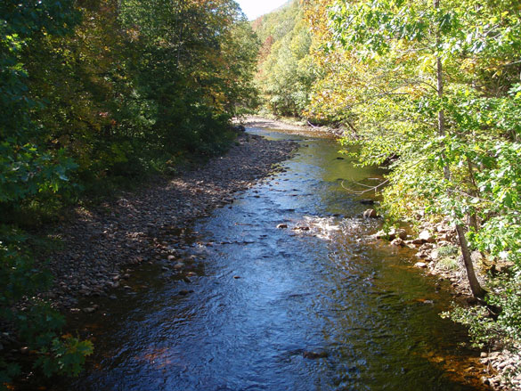
Habitat Highlight: Assessing aquatic connectivity in Nova Scotia
Habitat connectivity is essential to a healthy aquatic system: when habitat is more connected, fish populations are generally larger, healthier, and less susceptible to habitat degradation.
On this page
- Dams and other water control structures – determining amount of inaccessible habitat
- Watercourse crossings – determining crossing density
- Management actions to improve aquatic habitat connectivity
- Partnerships to improve aquatic habitat connectivity
- Footnotes
Dams and other water control structures – determining amount of inaccessible habitat
More than 600 dams and water control structures exist in Nova Scotia, many of which are contributing to aquatic habitat fragmentation. The majority of these dams are used for water impoundment or storage for hydroelectricity generation, municipal purposes, and agricultural uses. Many of the smaller dams are used to impound water for wildlife conservation, such as creating and maintaining wetlands.
For each primary watershed in Nova Scotia, an analysis was conducted to determine the amount of upstream habitat that is inaccessible to migrating fish, presented as the proportion of total stream length upstream of impassable dams or other water control structures. The amount of habitat inaccessible to migratory fish species is a factor of both the location of a water control structure within the watershed (i.e. a large dam at the outlet of the main stem of the river is likely to restrict access to a much greater area of fish habitat than a small water control structure on a tributary in the headwaters of the watershed) and whether there is fish passage at the structure. For this analysis, fish passage was determined based solely on the presence or absence of a fishway at a particular dam location and did not include an assessment of the proper functioning or effectiveness of the fishway. A fishway, also known as a fish ladder, is a structure built around barriers to facilitate fish migration. It is important to note that fishways are usually designed for a specific species and may function poorly for non-target species or with water flow ranges that are beyond the operation range of the structure.
The analysis found that the watersheds with the highest proportion of inaccessible habitat due to dams are in southwest Nova Scotia as shown in the map below. In particular, the Mersey, Sissiboo/Bear, and St. Croix watersheds have the highest proportion of total stream length that is inaccessible to migratory fish species, due to dams or other water control structures without upstream fish passage (at 60.5%, 53.9%, and 41.5% respectively). In the Meteghan, Annapolis, and Gold watersheds more than 20% of the total stream length is upstream of dams with no upstream fish passage. Conversely, five watersheds either contain no dams or do not contain any dams without fish passage: the Missaguash, Country Harbour, Barrington/Clyde, Liscomb, and River Denys.
It is important to note that this assessment provides an indicator of the relative amount of accessible habitat for migratory species, but it does not factor in the quality of the habitat.
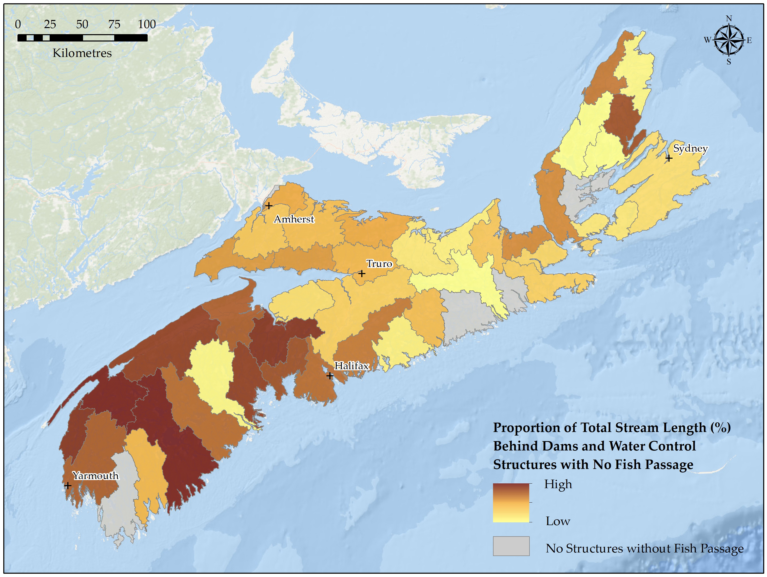
Proportion of total stream length behind dams and water control structures in Nova Scotia - Text version, data sources and methods
Data sources and methods
In order to complete the metric of the proportion of watershed stream length upstream of impassable dams, the location of dams (i.e. water control structures) within each primary watershed were compiled from a variety of sources, including:
- NS water control structure locations, as compiled by the NS Department of Environment and Climate Change, and Fisheries and Oceans Canada
- hydroelectric system water control structures
- salmon presence assessment tool (SPATLAS) barriers to fish passage (dams), developed by Fisheries and Oceans Canada
- water control structures operated for wildlife conservation purposes
Fish passage information was considered for each dam location, based on best available DFO information. Fish passage was determined based on the presence of a fishway, and information available on fish passage for select dam datasets. Assessment on the proper functioning and effectiveness of fishways was not part of this analysis, so it was assumed the presence of a fishway was indicative of a dam having adequate fish passage. Using the FIPEX extensionFootnote 1 within ArcGIS Desktop software, the total stream length (km) upstream of impassable dams was calculated for each primary watershed. The FIPEX tool makes use of a hydrological geometric network (e.g. National Hydro Network) representative of a watershed stream network, in conjunction with the locations of aquatic barriers to calculate various assessments of aquatic connectivity. All dams without fish passage were used for the FIPEX analysis, in which the total and immediate upstream lengths were calculated for each barrier location. The immediate length value corresponds to the length of stream network between a barrier and the next barrier upstream, while the total length refers to the entire stream network length upstream of a barrier, regardless of the presence of other barriers further upstream. To calculate the proportion of stream length upstream of impassable dams at the primary watershed scale, the sum of all immediate upstream length values were calculated for all barriers within a watershed, and divided by the total stream length of the entire watershed.
Data sources for the base map
General Bathymetric Chart of the Oceans GEBCO_08 Grid, National Oceanic and Atmospheric Administration, National Geographic, Garmin, HERE, Geonames.org, and Esri.
| Primary watershed | Proportion of stream length upstream of dams with no upstream fish passage |
|---|---|
| Annapolis | 27.07 |
| Barrington / Clyde | - |
| Cheticamp River | 6.39 |
| Clam Harbour / St. Francis | 2.82 |
| Country Harbour | - |
| East / Indian River | 17.51 |
| East / Middle / West (Pictou) | 0.86 |
| East / West (Sheet Harbour) | 3.93 |
| Economy | 5.02 |
| French | 0.49 |
| Gaspereau | 16.39 |
| Gold | 20.95 |
| Grand | 0.65 |
| Herring Cove / Medway | 8.93 |
| Indian | 17.51 |
| Isle Madame | 2.47 |
| Kelly / Maccan / Hebert | 3.24 |
| Kennetcook | 2.31 |
| LaHave | 0.29 |
| Liscomb | - |
| Margaree | 0.11 |
| Mersey | 60.50 |
| Meteghan | 28.41 |
| Missaguash | - |
| Musquodoboit | 6.91 |
| New Harbour / Salmon | 3.08 |
| North / Baddeck / Middle | 0.08 |
| Parrsboro | 5.10 |
| Philip / Wallace | 3.78 |
| River Denys / Big | - |
| River Inhabitants | 5.86 |
| River John | 4.76 |
| Roseway / Sable / Jordan | 4.07 |
| Sackville | 10.01 |
| Salmon / Debert | 4.06 |
| Salmon / Mira | 2.34 |
| Shubenacadie / Stewiacke | 3.07 |
| Sissiboo / Bear | 53.93 |
| South / West | 3.40 |
| St. Croix | 41.54 |
| St. Mary’s | 0.13 |
| Tangier | 0.32 |
| Tidnish / Shinimicas | 4.21 |
| Tracadie | 6.36 |
| Tusket River | 11.58 |
| Wreck Cove | 0.18 |
Historic impacts of dams on endangered Atlantic whitefish
Once an anadromous species found in the Tusket and Petite Rivière watersheds, Atlantic whitefish have undergone significant declines and are now restricted in distribution to three lakes within the Petite Rivière system. The reasons for its decline are not fully known, but the construction of barriers to migration are thought to have contributed to this decline. Since Europeans colonized Nova Scotia, most of the main rivers and streams in southwestern areas of the province have been dammed to some extent. In 1926, there were 92 dams on 33 southwestern Nova Scotia rivers between the Annapolis and Sackville Rivers. Many of the dams on the Petite and Tusket rivers pre-date the Fisheries Act being enacted in 1868Footnote 2.
Watercourse crossings – determining crossing density
Watercourse crossings are installed in places where road and rail lines cross streams or rivers. Generally, bridges are used for large crossings, while culverts are used for smaller crossings.
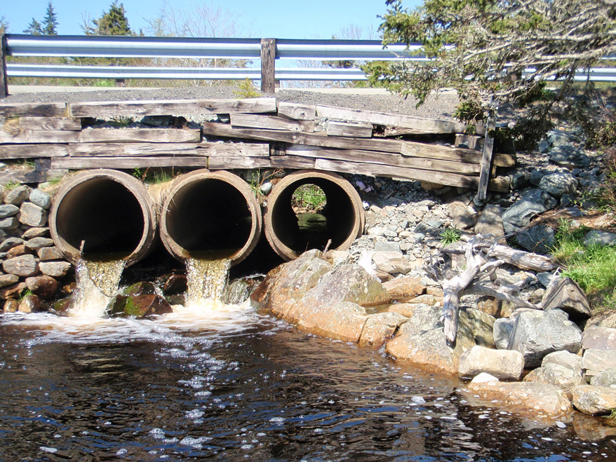
Impacts on aquatic habitat are generally associated with improperly designed, installed, or functioning watercourse crossings, especially improperly functioning culvertsFootnote 3. For example, improperly designed or functioning culverts may be unable to handle high water flows, leading to flooding in both riparian and terrestrial areas, and damage to the watercourse upstream and downstream. In addition, improperly designed or functioning culverts can impede fish movement. Blocked, or “perched” culverts, can present a physical barrier to fish passageFootnote 4.
Culverts can also impact water levels and the velocity at which water flows. An oversized culvert can result in inadequate water depth for fish to swim through the culvert, while an undersized culvert can result in high water velocities that exceed the swimming ability of some fishFootnote 5. Most fish species native to Nova Scotia can swim for a few minutes before they need to rest. This means if a culvert is too long, fish will become exhausted before they can swim through it unless baffles or other features are designed to create resting areas within the culvert. Debris, such as vegetation, woody debris, or unnatural items, can accumulate over time at the inflow of culverts causing a physical barrier to fish passage.
There are more than 30,000 locations in Nova Scotia where roads cross streams or rivers. Culverts are found at the majority of these watercourse crossings. To derive the watercourse crossing density, the total number of crossings was divided by the total stream network length (km) for each primary watershed. The analysis found that the highest density of watercourse crossings are in the East/Middle/West (Pictou) (0.60 crossings/km), Isle Madame (0.54 crossings/km), Gaspereau (0.53 crossings/km), Meteghan (0.52 crossings/km), Tracadie (0.51 crossings/km), French (0.51 crossings/km), Annapolis (0.49 crossings/km), Sackville (0.49 crossings/km), Gold (0.46 crossings/km), and Parrsboro (0.45 crossings/km) watersheds. The watersheds with the lowest density of watercourse crossings are the Missaguash (0.03 crossings/km), Cheticamp River (0.08 crossings/km), Wreck Cove (0.13 crossings/km), Mersey (0.17 crossings/km), and Roseway/Sable/Barrington (0.18 crossings/km).
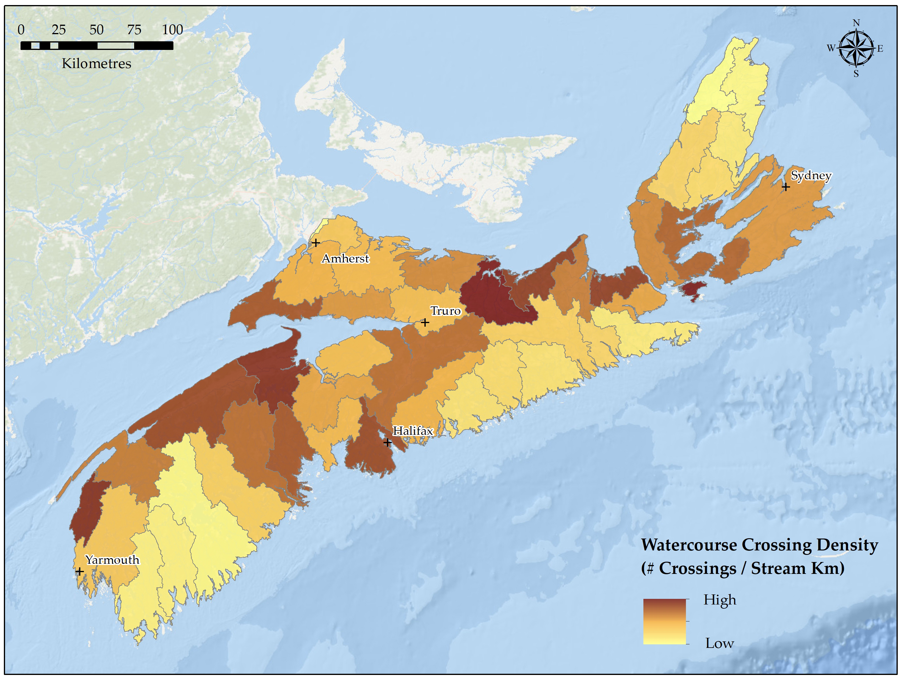
Density of watercourse crossings in Nova Scotia (#/km) - Text version
The stream road crossing density mapping was produced using the 1:50,000 Canvec National Road Network (NRN) in conjunction with the National Hydrographic Network (NHN). All road types were intersected with the NHN stream networks using the Intersect tool available in ArcGIS software, which generated point locations of all watercourse crossings. A spatial join was then applied which calculated the total number of the watercourse crossing point locations falling within each primary watershed. To derive the crossing density metric, the total number of crossings was divided by the total stream network length (km) for each primary watershed.
All final map products are presented using a quantile classification, in which each class contains an equal number of watersheds. For example, the watersheds with the 2 lowest densities of stream crossings fall within the first class, while the watersheds with the 2 highest densities of stream crossings are within the last class. Darker colours indicate watersheds with a higher density of stream crossings, dams, and proportion of watershed stream length upstream of impassable dams, while lighter colours are indicative of a lower density of stream crossings, dams, and proportion of watershed stream length upstream of impassable dams.
Data sources for the base map
General Bathymetric Chart of the Oceans GEBCO_08 Grid, National Oceanic and Atmospheric Administration, National Geographic, Garmin, HERE, Geonames.org, and Esri.
| Primary watershed | Stream crossing density (# crossings / stream km) |
|---|---|
| Annapolis | 0.49 |
| Barrington / Clyde | 0.20 |
| Cheticamp River | 0.08 |
| Clam Harbour / St. Francis | 0.40 |
| Country Harbour | 0.30 |
| East / Indian River | 0.38 |
| East / Middle / West (Pictou) | 0.60 |
| East / West (Sheet Harbour) | 0.24 |
| Economy | 0.42 |
| French | 0.51 |
| Gaspereau | 0.53 |
| Gold | 0.46 |
| Grand | 0.44 |
| Herring Cove / Medway | 0.31 |
| Indian | 0.22 |
| Isle Madame | 0.54 |
| Kelly / Maccan / Hebert | 0.38 |
| Kennetcook | 0.35 |
| LaHave | 0.43 |
| Liscomb | 0.24 |
| Margaree | 0.25 |
| Mersey | 0.17 |
| Meteghan | 0.52 |
| Missaguash | 0.03 |
| Musquodoboit | 0.39 |
| New Harbour / Salmon | 0.22 |
| North / Baddeck / Middle | 0.25 |
| Parrsboro | 0.45 |
| Philip / Wallace | 0.37 |
| River Denys / Big | 0.44 |
| River Inhabitants | 0.42 |
| River John | 0.42 |
| Roseway / Sable / Jordan | 0.18 |
| Sackville | 0.49 |
| Salmon / Debert | 0.36 |
| Salmon / Mira | 0.41 |
| Shubenacadie / Stewiacke | 0.42 |
| Sissiboo / Bear | 0.42 |
| South / West | 0.42 |
| St. Croix | 0.39 |
| St. Mary’s | 0.32 |
| Tangier | 0.22 |
| Tidnish / Shinimicas | 0.34 |
| Tracadie | 0.51 |
| Tusket River | 0.33 |
| Wreck Cove | 0.13 |
In Nova Scotia, the Adopt a Stream program has developed tools to help local watershed organizations collect data on a variety of parameters that influence the passability of culverts in the province. By collecting information on the culvert (e.g. dimensions, materials, shape, bottom material), how the culvert functions (e.g. backwatering, embedment, outflow drop, slope), and the upstream and downstream characteristics (e.g. elevation, water depth, velocity), calculations of the passability of the culvert can be madeFootnote 6. The Adopt a Stream Aquatic Connectivity Analytical Database (ACAD) houses information on the passability of culverts for five fish species (Atlantic salmon, brook trout, American eel, shad, and smelt) and characterizes culverts as: full barriers, partial barriers, potential barriers, passable, or data deficient.
The ACAD culvert data was analyzed for the four primary watersheds that had the most culvert assessments completed: Annapolis, Shubenacadie/Stewiacke, St. Mary’s, and LaHave. While the number of culverts assessed is only a portion of the total number of culverts in these respective watersheds, the information presented in the table below offers insight into the passability of culverts across Nova Scotia. For example, between 26 and 47% of culverts in these four watersheds are a full barrier to fish passage.
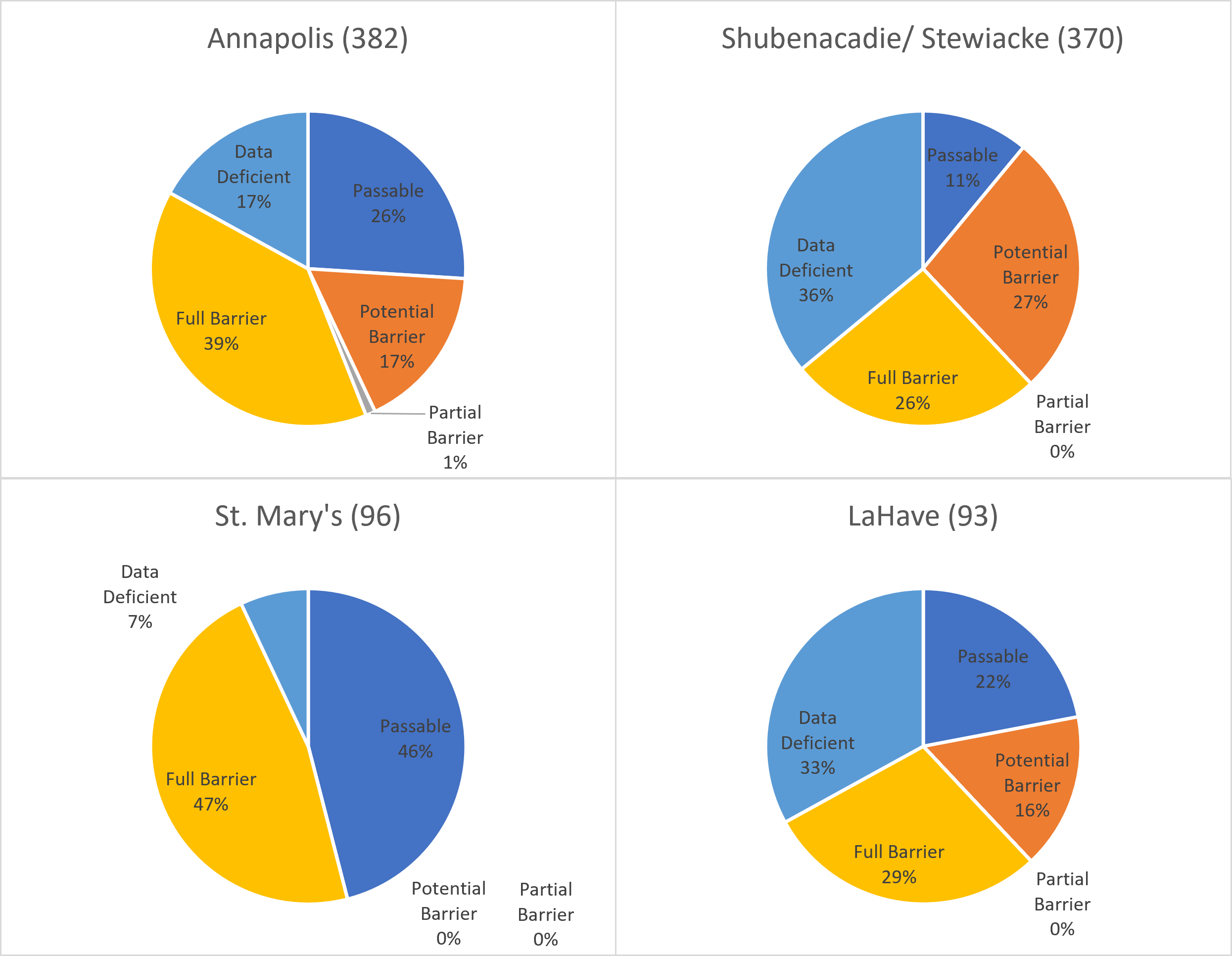
Passability of assessed culverts in four watersheds of Nova Scotia - Text version
| Culvert Status | Percentage of assessed culverts | |||
|---|---|---|---|---|
| Annapolis (382) | Shubenacadie/ Stewiacke (370) | St. Mary’s (96) | LaHave (93) | |
| Passable | 26% | 11% | 46% | 22% |
| Potential Barrier | 17% | 27% | - | 16% |
| Partial Barrier | 1% | - | - | - |
| Full Barrier | 39% | 26% | 47% | 29% |
| Data Deficient | 17% | 36% | 7% | 33% |
- Note that these percentages may not be representative of the passability of all culverts in each watershed.
Management actions to improve aquatic habitat connectivity
There is a spectrum of approaches that can be used to address fish passage issues posed by dams and watercourse crossings from the use of regulatory tools to partnerships with local watershed groups that are remediating culverts to improve passage.
Regulatory tools
Works, undertakings and/or activities (WUAs) must provide for fish passage to be in compliance with the Fisheries Act. WUAs that could impact connectivity and fish passage also generally require provincial regulatory oversight. DFO has arrangements with the Province of Nova Scotia to provide a “one window” approach for project reviews and advice under the Fisheries Act, Species at Risk Act, and the Activities Designation Regulations of the provincial Environment Act. The "one window" approach does not negate DFO’s ability to use other ministerial tools for the protection of fish and fish habitat.
Consult the provincial requirements for further information.
DFO reviews proposals for:
- the maintenance and refurbishment, or replacement of existing dams
- proposed new structures
- overall hydro-electric, water impoundment, water-withdrawal, or other water management licenses
These projects are reviewed on a case-by-case basis with the goal of improving fish passage and reducing upstream and downstream impacts.
The planning, design, and installation of new culverts and the maintenance of existing culverts must meet the requirements for fish passage under the Fisheries Act. In 2002, DFO carried out a random assessment of 50 small culvert installations in Nova Scotia completed between 1996 and 2000. The assessment found that a significant portion of the culvert installations contributed to habitat fragmentation; that is, where fish passage was prevented by perched culverts and/or by culverts with a slope greater than 0.5%. In many cases, habitat fragmentation could have been reduced through redesigning the culvertFootnote 7. The updated Guidelines for the Design of Fish Passage for Culverts in Nova ScotiaFootnote 8 were designed to provide information necessary for the proper design, installation, and maintenance of culverts so that these watercourse crossings meet the requirements for fish passage under the Fisheries Act. In combination with increased compliance and conformance monitoring and the provision of installer training, these guidelines are helping to ensure that fish can move more freely through Nova Scotia watersheds.
Restoration
One tool to address the impacts of dams it to install a fishway to improve connectivity. Fishways may be used around natural (e.g. waterfalls) or anthropogenic (e.g. dams) barriers and must be designed with consideration for specific species (particularly fish swimming capabilities) as well as hydrology. Denil designed one of the earliest fishway structures in the early 1900s. The Denil design includes a series of baffles perpendicular to the flow of the water, which creates eddies to reduce downstream velocity.
In cases where an existing culvert is not expected to be replaced in the near future, but is not allowing for fish passage, then remediation may be necessaryFootnote 9. In prioritizing culverts for remediation, there are a number of factors that need to be considered, including the amount of upstream habitat, the complexity of the site, the state of the existing culvert, and the presence of aquatic invasive speciesFootnote 10.
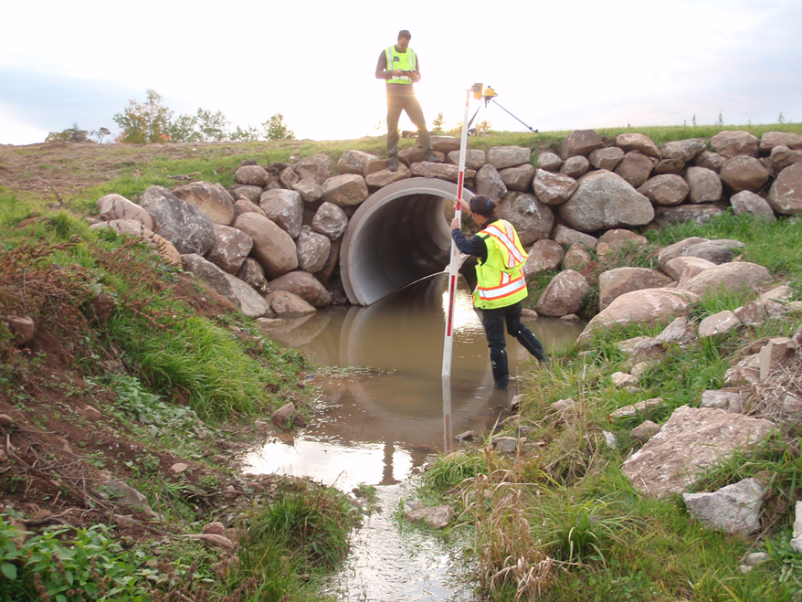
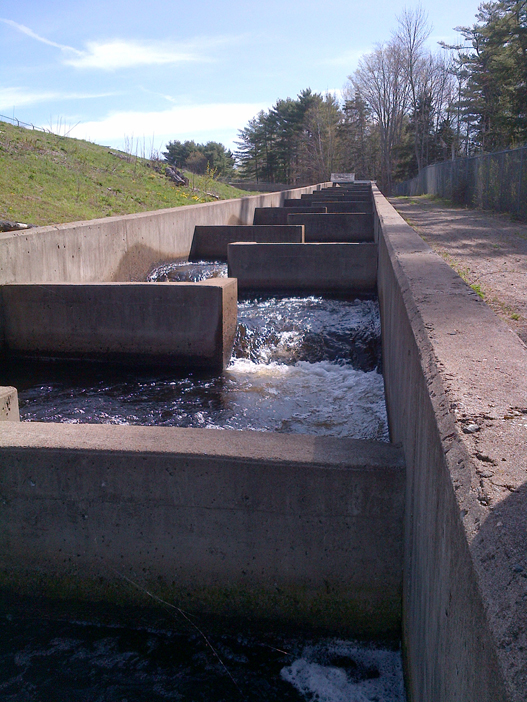
Remediation techniques include installing an outflow chute, baffles, downstream weirs, or fish ladder boxesFootnote 11Footnote 12:
- Outflow chute
- A device that can be installed on box or circular culverts where the existing culvert outlet elevation is too high and the culvert is “perched”. Chutes are a temporary solution, providing a narrow notch which guide the fish into the culvert. A chute also back waters the culvert creating water depth.
- Baffle
- A devices installed on the floor of a box or circular culvert to hold back the flow of water which slows the water velocity. Baffles also create areas where fish can rest.
- Weir
- A control structures that can be installed downstream of a culvert to dissipate energy and back water the culvert.
- Fish ladder box
- A device used where other remediation techniques are not sufficient due to large outflow drops. These operate similarly to a miniature fishway.


Image 1: A chute installed on a perched culvert.
Image 2: A large culvert with a series of baffles.
Image 3: A large culvert with a series of baffles.
Image 4: A fish ladder box adjacent to a culvert.
While various structures, such as dams and culverts, can impede the movement of native fish impacting their ability to carry out various life processes, these structures can also prevent the movement and spread of aquatic invasive species. This poses a challenge for determining how to restore habitat connectivity in areas where aquatic invasive species have been recorded. Decisions must balance the risk of isolating native fish species with the risk of increasing the spread of invasives.
Partnerships to improve aquatic habitat connectivity
Addressing fish passage issues across Nova Scotia is a collaborative effort between DFO, the Province of Nova Scotia, Indigenous organizations, and many non-governmental partners. In addition to the roles of the Province and the Adopt a Stream program described above, many organizations contribute to the restoration and remediation of barriers to improve fish passage in Nova Scotia.
This content is also available in an interactive format: (StoryMap: Partnerships to improve aquatic habitat connectivity).
Five watersheds projects
With funding from the Coastal Restoration Fund, the Maritime Aboriginal Peoples Council (MAPC) addressed issues of habitat connectivity across the Salmon/Debert primary watershed, specifically for the Chiganois, Debert, Folly, Great Village, and Portapique rivers, which include areas designated as critical habitat for the endangered inner Bay of Fundy Atlantic salmon. As a first step, the project team mapped the locations of all road-stream crossings in these five watersheds and then visited crossings on the main rivers and tributaries to assess the potential for free passage of fish. While many crossings were found to be bridges or properly installed culverts that allowed for fish passage, there were some crossings identified that posed a threat to fish passage. For example, on Galloping Brook, a tributary of the Chiganois River, the project team located a wooden culvert that was ”perched” and posed a height barrier for fish passing upstream. At the time of the initial field assessments, over 1,000 gaspereau were documented in a pool downstream of the culvert unable to proceed further upstream. MAPC, in conjunction with several partners, installed a Denil Structure to bypass the culvert and facilitate fish passage. The Denil Structure provides a gradual upward slope and contains baffles that reduce the water velocity and provide areas of rest during passage through. MAPC has been monitoring the site since the Denil Structure was installed and have recorded fish using the structure to make their way to previously inaccessible, high quality spawning areas above the culvert.
Marshall’s Crossing Bridge
The Clean Foundation identified two steel culverts on Marshall’s Crossing in the East River watershed in Pictou County that were restrictions to both tidal and freshwater flow and were posing barriers to fish passage. One of the culverts had collapsed from the weight of the road and the other was at risk of failure as well. In 2019, working with partners, Clean Foundation coordinated the replacement of the culverts with a bridge to restore a more natural flow to the system, restore fish passage, and improve tidal wetland habitat. Clean Foundation has been conducting extensive monitoring of the site to learn more about how the project has benefited the ecosystem, including monitoring the hydrology, vegetation, fish, and soil at the site. The project was funded by the Coastal Restoration Fund and has been recognized by Clean50 for its use of a participatory approach and strong partnerships to restore natural ecosystem dynamics.
To learn more about this project, see the Clean Foundation’s Clean Coasts website and view the Marshall’s Crossing Bridge project video by Clean Foundation.
Stewiacke River barrier assessment and remediation
Since 2014, the Confederacy of Mainland Mi’kmaq’s (CMM) Mi’kmaw Conservation Group (MCG), with funding from the Habitat Stewardship Program, has conducted a long-term project assessing and improving fish passage throughout the Stewiacke watershed. The Stewiacke watershed contains critical habitat for endangered inner Bay of Fundy population of Atlantic salmon. There are over 1,000 potential water crossings in the watershed and MCG has carried out a number of projects to systematically assess culverts, identify those that pose a barrier to salmon migration, and prioritize remediation activities. In determining priorities, MCG considers the amount of available upstream habitat that will be made accessible, the quality of upstream habitat, and the presence of aquatic invasive species. Based on the assessments completed, MCG has remediated several culverts throughout the Stewiacke watershed, through the addition of chutes or baffles, or removal of debris, contributing to making more habitat accessible for Atlantic salmon and other species. For example, this site on Fall Brook benefited from the installation of a metal chute, a baffle, and a low-flow barrier. In addition to their work on the river, MCG have developed a number of outreach materials to educate students and young people about Atlantic salmon. The Go Plamu Go game gives students an opportunity to explore the culvert database and see the impacts of barriers on Atlantic salmon in a fun and interactive manner.
Fish passage and aquatic invasive species
The Clean Annapolis River Project (CARP) and the Nova Scotia Salmon Association’s Adopt a Stream Program have collaborated to develop a tool to help watershed groups prioritize aquatic connectivity improvement projects. Specifically, the Decision-Making Framework for Fish Passage Projects in Nova Scotia tool provides habitat managers with guidance and a framework to assess risks and benefits of improving habitat connectivity in areas with aquatic invasive species. The framework assesses the risk of invasion (i.e. risks from aquatic invasive species associated with improving fish passage) versus isolation (i.e. risk posed to native species from fragmented habitat). Development of the tools was funded by the Habitat Stewardship Program for Aquatic Species at Risk.
- Date modified: