
Conservation and Harvesting Plan for the southern Gulf of St. Lawrence fall herring fisheries
Moncton – Fisheries and Oceans Canada (DFO) is announcing today the fall Southern Gulf of St. Lawrence herring (Herring Fishing Areas 16A to G and 17) Conservation and Harvesting Plan.
On August 20, 2020, DFO announced that the Total Allowable Catches (TAC) will be 12,000 t for 2020. This decrease in the TAC for the fall herring fishery is necessary to promote stock rebuilding which is currently in the cautious zone of the Precautionary Approach framework to the healthy zone.
The quota will be distributed based on the existing fleet shares for the various fleets involved and the following allocations were established in order to reach the TAC of 12,000 t.
| Fleet | 2020 |
|---|---|
| Inshore fleet Areas 16A-16G | 13,692 |
| Inshore fleet in Area 17 | 180 |
| Gulf large purse seine fleet | 4,128 |
Description
The table “Fleet allocations established based on historical sharing arrangement in metric tons in order to reach catch of 12,000 tonnes” indicate that the allocation for the inshore fleet for areas 16A to 16G is 13,692 tonnes, for the inshore fleet in area 17 is 180 tonnes and the Gulf large purse seine fleet is 4,128 tonnes.
| Herring Fishing Area | 2020 |
|---|---|
| Reserve (initially distributed)* | 1,005 |
| Basic allocation including the distribution of reserve | |
| 16A | 22 |
| 16B | 6,509 |
| 16C | 2,662 (C&E) |
| 16D | 90 |
| 16E | see above |
| 16F | 2,734 |
| 16G | 1,818 |
| 17 | 180 |
* For more details on inshore quota distribution rules, please refer to Annex 1.
Description
The table “Inshore fleet quota distribution in Herring Fishing Areas 16A to 16G and 17” describe the allocation per herring fishing areas in metric tonnes. The reserve which is already distributed within the allocation described below is 1,005 tonnes. For more information on the inshore quota distribution rules, please refer to Annex 1. The basic allocation including the distribution of the reserve is 22 tonnes for 16A, 6,509 tonnes for 16B, 2,662 tonnes for 16C and 16E, 90 tonnes for 16D, 2,734 tonnes for 16F, 1,818 tonnes for 16G and 180 tonnes for 17.
Large Purse Seine fleet fishery on “the Edge” (4T)
This fishery, designed to target fall spawners during the month of May and June, will continue in the 2020 fishing seasons with the same parameters and management measures as in 2019. This fleet is authorized to fish their fall herring quota along the Edge in 4T during the spring season (May-June) using purse seine gear (Chart 4). A small fish protocol that reduces the remaining available quota according to the percentage of herring smaller than 23.5 cm (fork length) in the catch will be maintained. As in 2019, management measures will include: 20% independent at-sea observer coverage, 100% dockside monitoring, and mandatory vessel monitoring system to monitor this fishery. (See annex 2 for all details).
Quota reconciliation
Quota reconciliation in the Gulf herring fisheries will continue to be applied in 2020. Quota overruns from the 2020 fisheries will be deducted, in equal amounts, from the quota of the following year in the same Herring Fishing Area and season. Quantities will be rounded to +/- 10 kg.
Carry forward of quota
Considering that the HFA16 herring fall component stock is now in the cautious zone of the precautionary approach framework, the carry forward of the quota will no longer be possible. According to the Quota Carry-Forward Guidelines for Atlantic Canada, quota carry forward will be considered only when stocks are in the healthy zone. When stocks are in the cautious zone, quota carry forward will be considered if the stock is on a positive trend and the TAC is increasing.
Mesh size measurement
Mesh size as applicable in the herring fishery is defined in the Atlantic Fishery Regulations as follow:
- mesh size means, in respect of netting the total length of the twine measured along two contiguous sides of a single mesh, including the distance across the knot joining those sides but not including any other knots,
- See diagram below
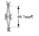
Please note that the measurement is taken with the net pulled tight which would be harder to display in the diagram.
Herring dependant fish harvesters
Given the current status of the herring stock, herring dependant fishers are encouraged to continue to work with their respective organizations in order to identify options to improve their economic viability.
Information
Ben Moore
Resource Management
Fisheries and Oceans Canada
Charlottetown, PE
(902) 370-7094
Sandra Comeau
Resource Management
Fisheries and Oceans Canada
Tracadie, NB
(506) 395-7765
Alan Dwyer
Resource Management
Fisheries and Oceans Canada
Antigonish, NS
(902) 735-7114
Caroline Leclerc
Resource Management
Fisheries and Oceans
Gaspé, QC
(418) 368-5559
Josée Richard
Resource Management
Fisheries and Oceans
Cap-aux-Meules, QC
(418) 986-2095
Mario Gaudet
Resource Management
Fisheries and Oceans Canada
Moncton, NB
(506) 871-0648
2020 Conservation Harvesting Plan
Fall inshore gillnet fishery
- Dockside Monitoring Program (DMP) and weekend closures are a requirement in most fishing areas. (See Table 1)
- Gillnets are restricted to a maximum of 150 fathoms in length and 125 mesh deep with the exception of 16F which will be 100 fathoms in length, 16B which will be 125 fathoms in length and 16G Southside which will be 100 mesh deep. The minimum mesh size in all areas is 66.7 mm except 63.5 mm in 16A.
- Tagging of all gillnets in all HFAs is required in 2020, with one tag for every 15 fathoms of net.
- Other management measures are outlined in Table 1.
Baie des Chaleurs (HFA 16 B) fall fishery
Early Fishery
As in previous years, there is an early fishery in July (July 1-31), with a maximum of 185 t. Any uncaught quota will be transferred to the main roe fishery. Fish harvesters will be limited to one landing per day, with a maximum weight of 10,206 kg.
Main roe fishery
The season will open on August 23, 2020 with a quota of 6,135 t.
The fishery will be closed weekdays between 13:00 and 19:00 (Atlantic Daylight Time) and every weekend from 13:00 Friday until 19:00 Sunday (Atlantic Daylight Time). No nets will be allowed in the water during these closed periods.
The use of a maximum of one (1) set of nets only will be authorized.
Fish harvesters will be limited to one landing per day, with a maximum weight of 10,206 kg or with a maximum daily limit which will be self-managed by industry when participating in the pilot project.
Small Seiners
The purse seine fishery will be allowed in the Baie des Chaleurs from July 1 until July 31, 2020, and from September 1 until December 31, 2020 except west of a line between Grande-Anse (NB) and Paspébiac (QC) in order to limit catches of spring spawners.
The purse seine fishery will continue to be subject to a small fish protocol.
Summer fishery in a portion of HFA 16E
A summer herring fishery (starting on July 1, 2020) is authorized in a portion of HFA 16E with a set quota of 257 t. The objective of the summer fishery is to provide some fishing opportunities to herring fish harvesters who have had a very limited or non-existent fishery in the spring.
To allow for a reasonable distribution of the resource among fish harvesters, the fishery will only open in the waters inside a line from Fagan Point, N.B., to Cape Egmont, P.E.I., and the lobster line separating Lobster Fishing Area 25 and 26A from Victoria Harbour, P.E.I. to Pugwash, N.S. (Chart 1). The remainder of 16E remains closed until the opening of the roe fishery.
Fish harvesters will have to choose between a summer fishery or a fall fishery. Those opting for a summer fishery will be required to request summer herring licence conditions by calling 1-855-634-2355 or by e-mail at Gulfinfogolfe@dfo-mpo.gc.ca before being authorized to participate in the summer fishery. The fishery will open at noon (12:00 p.m.), Atlantic Daylight Time, on July 1, 2020.
Any uncaught quota from the summer fishery will be transferred to the competitive quota for both groups A and B of the main roe fishery.
Fall fishery in the 16C and 16E Herring Fishing Areas
Main roe fishery for Groups A and B
The main roe fishery will start on August 23, 2020 with an allocation of 399 t for both groups A and B. When this quota is reached, the remaining allocation will be divided between group A (New Brunswick fish harvesters) and group B (Prince Edward Island and Nova Scotia fish harvesters).
The fishery will be closed weekdays between 11:00 and 19:00 (Atlantic Daylight Time) and every weekend from 11:00 Friday until 19:00 Sunday (Atlantic Daylight Time). No nets will be allowed in the water during these closed periods.
Fish harvesters will be limited to one landing per day, with a maximum weight of 9,752 kg or with a maximum daily limit which will be self-managed by the industry when participating in the pilot project (group A only).
Fall fishery in Herring Fishing Area 16F
The 16F fall fishery will start on September 7, 2020 with an allocation of 2,734 t (summer and fall fishery allocations). The fishery will close no later than on October 2.
The fishery will be closed weekdays between 12:00 (noon) and 18:00 (Atlantic Daylight Time) and every weekend from 12:00 (noon) Friday until 18:00 Sunday (Atlantic Daylight Time). No nets will be allowed in the water during these closed periods.
Fish harvesters will be limited to one landing per day, with a maximum daily limit self-managed by the industry.
Fishermen’s Bank and Northeast PEI (HFA 16G) summer/fall fishery
The summer and fall fishery in HFA 16G will occur in two distinct periods and zones within HFA 16G (Northside and Southside) to allow for a reasonable distribution of the resource among fish harvesters.
The fishery will be closed every weekend from 15:00 Friday until 15:00 Sunday (Atlantic Daylight Time). No nets will be allowed in the water during these closed periods.
Summer fishery
A summer fishery will commence on July 14, 2020 for both Northside and Southside of HFA 16G and fish harvesters will fish against a reserve quota of 448 t until the main roe fishery opens, or until the quota is caught.
Fall fishery
When the main roe fall fishery opens on September 6, 2020 these fish harvesters will fish against the remaining 16G quota but must remain within the defined areas, until the fishery closes. Any remaining quota after September 18, 2020 will be accessible to all harvesters in their chosen zone in a late fishery. The fishery will close no later than on October 9.
Fish harvesters will be limited to either one or two landings per day depending on the fishing area , with a maximum daily limit self-managed by the industry of 4,536 kg.
Purse seine fishery for vessel greater than 19.81 meters
- A cap on fall spawners of 2,064 t in the Baie des Chaleurs will be implemented.
- Catches of fall spawners during the spring fishery along the edge of the Laurentian channel will be counted towards the large purse seiner fall quota.
- The purse seine fishery for vessel greater than 19.8 meters will be allowed in the Baie des Chaleurs from July 1 until July 31, 2020 and from September 1 until December 31, 2020, except west of a line between Grande-Anse (NB) and Paspébiac (QC) in order to limit catches of spring spawners.
- The purse seine fishery for vessel greater than 19.8 meters will be closed from January 1 to December 31 in a portion of HFA 16G off the northeast coast of PEI (Chart 2)
- Uncaught quota from the spring will be transferred to the fall, and access to the northern portion of 4Vn (HFA 17) will be authorized starting November 1. However, the amount and the conditions under which the fishery will take place in 4Vn (HFA 17) will be addressed in the Maritimes Region Herring Management Plan.
- All vessels must be equipped with an operational Vessel Monitoring System during fishing activities.
- There will be a minimum of 20% at-sea observer coverage during fishing activities.
- The purse seine fishery for vessel greater than 19.8 meters will continue to be subject to a small fish protocol.
| Fishing Area | DMP/CMP | Quota (t) | Period | Net (mesh size/deep/length) | Closures | Trip limit |
|---|---|---|---|---|---|---|
| 16A – Île Verte | CMP - declaration of 100% of catches through the radio and dockside verification for 25% of landings | 22 | July 1 – Dec. 31 | 63.5 mm min / 125 mesh / 150 fathoms | None | One landing a day of 9,072 kg (20,000 lbs) |
| 16B – Baie des Chaleurs (Fixed Gear) | 100% DMP in N.B. CMP in P.Q. - declaration of 100% of catches through the radio and dockside verification for 25% of landings |
185¹ | July 1-31 | 66.7 mm min / 125 mesh / 125 fathoms | None | One landing per day of 10,206 kg (22,500 lbs) |
| 6,135 | Aug. 23 to September 25 | 13:00 Friday to 19:00 Sunday* 13:00 to 19:00 weekdays* | One landing per day, 10,206 kg (22,500 lbs) or daily limit self-managed by industry | |||
| Small Seiners | 100% DMP | 189 | July 1 – July. 31 Sept. 1 – Dec. 31 |
N/A | N/A | N/A |
| 16 C&E –Escuminac, Western PEI and northern GNS | 100% DMP | 257² | July 1 – Aug. 21 | 66.7 mm min / 125 mesh / 150 fathoms | 18:00 Friday to 18:00 Sunday* | One landing per day of 5,670 kg (12,500 lbs) |
| 399 (all) | Aug. 23 | 11:00 Friday to 19:00 Sunday 11:00-19:00 weekdays* | Maximum daily limit of 9,752 kg (21,500 lbs) or daily limit self-managed by industry (for Group A) | |||
| 1,003 (Group A) | After competitive fishery | |||||
| 1,003 (Group B) | After competitive fishery | |||||
| 16D –Magdalen Islands | CMP - logbook, declaration of 100% of catches through the radio and dockside verification for 25% of landings | 90 | July 1 – Dec. 31 | 66.7 mm min / 125 mesh / 150 fathoms | None | None |
| 16F – Pictou | 100% DMP | 49 | July 5 – August 21 | 66.7 mm min / 125 mesh / 100 fathoms | 12:00 Friday to 18:00 Sunday 12:00 to 18:00 weekdays | One landing per day, with daily limit self-managed by industry |
| 2,685 | September 7 – October 2 | |||||
| 16G –Northside (Chart 3) | 100% DMP | 448 for N+S | July 14 – Sept. 4 | 66.7 mm min / 125 mesh / 150 fathoms | 15:00 Friday to 15:00 Sunday | Maximum 2 landings per day, with daily limit self-managed by industry |
| 20% of remaining quota (1,224 t + remaining in summer fishery) | Main roe fishery Sept. 6 – Sept. 18 |
Maximum 2 landings per day, with daily and weekly limit self-managed by industry | ||||
| 16G – Southside | 100% DMP | 448 for N+S | Summer fishery July 14 – Sept. 4 |
66.7 mm min / 100 mesh / 150 fathoms | 15:00 Friday to 15:00 Sunday | Maximum 2 landings per day, with daily limit self-managed by industry |
| 80% of remaining quota (1,224 t + remaining in summer fishery | Main roe fishery Sept. 6 – Sept. 18 |
Maximum 2 landings per day, with daily and weekly limit self-managed by industry | ||||
| 16G – Fishermen’s Bank | 100% DMP | Remaining quota | Late fishery Sept. 20 – Oct 9 |
66.7 mm min Northside -125 mesh/150 fathoms Southside – 100 mesh/150 fathoms |
15:00 Friday to 15:00 Sunday | Maximum 2 landings per day (Northside) and 1 landing per day (Southside), with consistent daily and weekly limit self- managed by industry |
* Atlantic Daylight Time
1 – If any quota remains from the early fishery, the remainder will be added to the roe fishery.
2 – A portion of 16E is open. Fish caught in that portion of 16E must be landed in that open area.
Description
In 16A, there is a mandatory declaration of all catches by radio and dockside monitoring of 25% of landings. The allocation is 22 tonnes. The period of fishing is July 1 until December 31. The minimum mesh size is 63.5 mm, the net must be a maximum of 125 meshes deep and no longer than 150 fathoms. A maximum of one landing per day is allowed with a daily landing limit of no more than 9,072 kg.
In 16B, for vessel using gill nets, in New-Brunswick there is a mandatory declaration of all catches to dockside monitoring companies and 100% dockside monitoring of landings except in certain northern New-Brunswick ports where there is a mandatory declaration of all catches and dockside monitoring of 25% of landings. In Québec, there is a mandatory declaration of all catches by radio and dockside monitoring of 25% of landings. The minimum mesh size is 66.7 mm, the net must be a maximum 125 meshes deep and no longer than 125 fathoms
From July 1 to July 31, the allocation is 185 tonnes (if any quota remains, the remainder will be added to the roe fishery) and a maximum of one landing per day is allowed with a daily landing limit of no more than 10,206 kg.
Between August 23 and September 25, the allocation is 6,135 tonnes. There will be daily closures between 1 p.m. and 7 p.m. and weekly closures between 1 p.m. on Friday to 7 p.m. on Sunday. A maximum of one landing per day is allowed with a daily landing limit of no more than 10,206 kg or a daily limit self-managed by the industry.
For vessels less than 19.812 metres using a purse seine, there is a mandatory dockside monitoring of all landings in Québec and New-Brunswick. The allocation is 189 tonnes and the season if from July 1 to July 31 and then from September 1 until December 31.
In 16C and 16E, there is a mandatory dockside monitoring of all landings. The minimum mesh size is 66.7 mm, the net must be a maximum 125 meshes deep and no longer than 150 fathoms.
From July 1 to August 21 there is a portion of 16E that is open for a “summer” fishery. Fish caught in that portion of 16E must be landed in that open area. The allocation from July 1 to August 21 is 257 tonnes. There will be weekly closures from 6 p.m. on Friday until 6 p.m. on Sunday. A maximum of one landing per day is allowed with a daily landing limit of no more than 5.670 kg.
The roe fishery is starting on August 23 with an allocation of 399 tonnes for all 16C and 16E until the quota is caught. Then then Group A and Group B will each receive a quota of 1,003 tonnes. There will be daily closures between 11 a.m. and 7 p.m. and weekly closures between 11 a.m. on Friday to 7 p.m. on Sunday. A maximum of one landing per day is allowed with a daily landing limit of no more than 9,752 kg (for both Group A and Group B) or a daily limit self-managed by the industry for Group A only.
In 16D, there is a mandatory declaration of all catches by radio and dockside monitoring of 25% of landings. The allocation is 90 tonnes. The period of fishing is July 1 until December 31. The minimum mesh size is 66.5 mm, the net must be a maximum of 125 meshes deep and no longer than 150 fathoms.
In 16F, there is a mandatory dockside monitoring of all landings. The minimum mesh size is 66.7 mm, the net must be a maximum 125 meshes deep and no longer than 100 fathoms. There will be daily closures between 12 noon to 6 p.m. and weekend closures from 12 noon on Friday until 6 p.m. on Sunday. A maximum of one landing per day is allowed with a daily limit self-managed by the industry. From July 5 to August 21, the allocation is 49 tonnes and from September 7 until October 2, the allocation is 2,685 tonnes.
Herring Fishing Area 16G is divided between the north side and the south side. Please see Chart 3 for coordinates. There is mandatory dockside monitoring of all landings for both north and south side. On the north side, the minimum mesh size is 66.5 mm, the net must be a maximum of 125 meshes deep and no longer than 150 fathoms and on the south side the minimum mesh size is 66.5 mm, the net must be a maximum of 100 meshes deep and no longer than 150 fathoms. Both sides have a weekly closure from 3 p.m. on Friday until 3 p.m. on Sunday.
The summer fishery is from July 14 until September 4 with an allocation of 448 tonnes for both sides.
The main roe fishery starts on September 6 to September 18. The allocation for the north side will be 20% of the remaining quota of 1,224 tonnes plus the remaining quota from the summer fishery. The allocation for the south side will be 80% of the remaining quota of 1,224 tonnes plus the remaining quota from the summer fishery. From July 14 until September 18, a maximum of two landings per day is allowed with a daily limit self-managed by the industry.
The late fishery is from September 20 until October 9 for both sides fishing on the remaining quota. A maximum of two landings per day on the north side and a maximum of one landing per day on the south side is allowed with a daily limit self-managed by the industry for both sides.
CHART 1
Summer fishery in a portion of HFA 16E
Description
The summer fishery is to be conducted in that portion of 16E inside lines drawn from:
Point 1 46° 14' 00'' latitude North and 64° 14' 00'' longitude West (FAGAN POINT) in New Brunswick
Point 2 46° 24' 00'' latitude North and 64° 06' 00'' longitude West (CAPE EGMONT) on Prince Edward Island
Point 3 46° 12' 58'' latitude North and 63° 29' 26'' longitude West on Prince Edward Island
Point 4 46° 10' 35'' latitude North and 63° 28' 03'' longitude West
Point 5 45° 51' 45'' latitude North and 63° 42' 42'' longitude West in Nova Scotia
Note: Those reference points are based on the geodesic system North American Datum 1927 (NAD27). Positions are expressed in degrees, minutes and seconds.
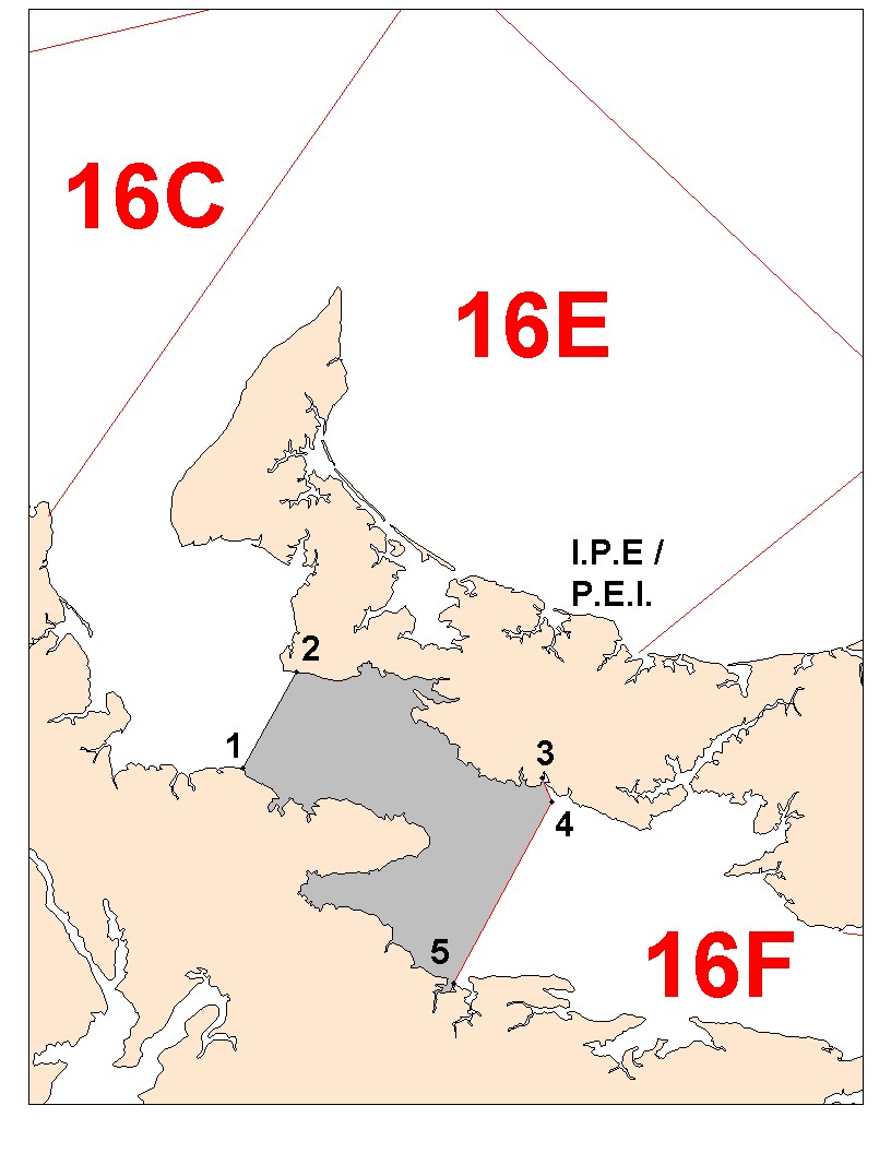
CHART 2
Closure of the commercial inshore herring fishery off northeast PEI (April 1 to June 30) and of the large purse seiners herring fishery (year round)
Description
There is a closure of the commercial inshore herring fishery off northeast PEI from April 1 to June 30 and of the large purse seiners herring fishery (year round) which is defined as the waters enclosed by the coastlines and rhumb lines (similar to straight lines plotted on a nautical chart) joining the following points in the order they are listed:
Point A 46°25’00” latitude North and 63°06’00” longitude West
Point B 46°33’00” latitude North and 63°06’00” longitude West
Point C 46°35’00” latitude North and 61°47’00” longitude West
Point D 46°27’00” latitude North and 61°43’00” longitude West
Point E 46°23’30” latitude North and 61°50’45” longitude West
Point F 46°26’55” latitude North and 61°58’25” longitude West
Note: These reference points are based on the geodesic system North American Datum 1927 (NAD27)
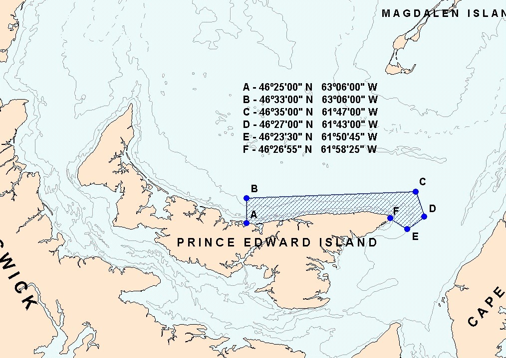
CHART 3
Northern portion of HFA 16G
Description
The Northern portion of HFA 16G is defined as that portion of Herring Fishing Area 16G as the waters enclosed by the coastlines and rhumb lines (similar to straight lines plotted on a nautical chart) joining the following point s in the order they are listed:
Point 1. 46° 26' 00'' latitude North and 63° 15' 00'' longitude West
Point 2. 46° 50' 00'' latitude North and 62° 32' 00'' longitude West
Point 3. 46° 56' 42'' latitude North and 61° 30' 00'' longitude West
Point 4. 46° 26' 55'' latitude North and 61° 30' 00'' longitude West
Point 5. 46° 26' 55'' latitude North and 61° 58' 25'' longitude West (EAST POINT)
Note: Those reference points are based on the geodesic system North American Datum 1927 (NAD27). Positions are expressed in degrees, minutes and seconds.
Annex 1
Fall Herring Reserve Distribution Rules for the 2020 sharing plan
- Each HFA will maintain its existing quota share at the end of the sharing plan.
- Establishment of a 1,005 t reserve consisting of 80% of the HFA 16A allocation, 80% of the HFA 16D allocation, 80% of the HFA 17 allocation* and 18.548% of the HFA 16G allocation. (*HFA 17 will provide 80% (180 t) of its allocation on a risk management basis to supply the reserve)
- The 1,005 t reserve will be initially allocated equally to HFA 16C&E (502 t) and HFA 16F (502 t).
- The initial reserve distribution will be evaluated yearly to take in consideration any conservation concerns.
- If the allocation for HFA 16A, 16D or 16G proves insufficient due to an apparent increase in abundance, the scenario will have to be revised.
| HFA | Current share | Quota based on current shares | Area reduction for the 1,005 t reserve | Quota after deduction of 1,005 t reserve | Distribution of the reserve 1,005 t | Basic allocation |
|---|---|---|---|---|---|---|
| 16A | 0.79% | 109 | 87 | 22 | 22 | |
| 16B | 47.54% | 6,509 | 6,509 | 6,509 | ||
| 16C&E | 15.77% | 2,160 | 2,160 | 502 | 2,662 | |
| 16D | 3.29% | 450 | 360 | 90 | 90 | |
| 16F | 16.30% | 2,232 | 2,232 | 502 | 2,734 | |
| 16G | 16.30% | 2,232 | 414 | 1,818 | 1,818 | |
| 17 | 180 | 144* | 180 | 180 | ||
| Total | 100% | 13,872 | 1,005 | 1,005 |
*Risk managed
Description
Annex 1 is the table “Fall-share scenario based on establishment of a reserve”.
The current share for 16A is 0.79% which means an allocation of 109 tonnes based on the current shares. 16A allocation will be reduced by 87 tonnes to create the 1,005 tonnes reserve. The quota after the deduction of the amount sent to the reserve and the basic allocation is 22 tonnes.
The current share for 16B is 47.54% which means an allocation of 6,509 tonnes based on the current shares and is the basic allocation.
The current share for 16C&E is 15.77% which means an allocation of 2,160 tonnes. An amount of 502 tonnes will be distributed to 16C&E from the reserve for a basic allocation of 2,662 tonnes.
The current share for 16D is 3.29% which means an allocation of 450 tonnes based on the current shares. 16D allocation will be reduced by 360 tonnes to create the 1,005 tonnes reserve. The quota after the deduction of the amount sent to the reserve and the basic allocation is 90 tonnes.
The current share for 16F is 16.3% which means an allocation of 2,232 tonnes. An amount of 502 tonnes will be distributed to 16C&E from the reserve for a basic allocation of 2,734 tonnes.
The current share for 16G is 16.30% which means an allocation of 2,232 tonnes based on the current shares. 16G allocation will be reduced by 414 tonnes to create the 1,005 tonnes reserve. The quota after the deduction of the amount sent to the reserve and the basic allocation is 1,818 tonnes.
The current allocation for herring fishing area 17 is 180 tonnes. An amount of 144 tonnes will be distributed to the reserve but the basic allocation will remain at 180 tonnes which will be risk managed.
Annex 2
Large Purse Seine Fleet Fishery on “the Edge” (4T)
- All Gulf large purse seine licence holders are authorized to conduct fishing activities in the spring on the Edge of 4T (Chart 4). This herring fishery targets fall origins spawners
- The large purse seine fleet is authorized to fish their fall herring quota along the Edge in 4T during the spring season (May-June). Catches will be counted towards this quota.
- All vessels must be equipped with an operational Vessel Monitoring System during fishing activities.
- There will be 20% observer coverage at sea during the spring fishery along the Laurentian channel (“Edge fishery”).
- The maximum authorized by-catch of mackerel and capelin is set at 10% each of the directed species. The maximum authorized by-catch of groundfish is set at 5% of the directed species. Monitoring and sampling for by-catch species will be conducted at sea and the by-catch may be verified at dockside by fishery officers.
- A small fish protocol is in place to control the capture of juvenile herring during the purse seine fishery with a 100% dockside monitoring. The small fish protocol reduces the remaining available quota according to the percentage of herring smaller than 23.5 cm (fork length) in the catch.
- A scientific protocol has been developed to verify the spawning component of the herring caught. The proportion of spring and fall spawners in the catch will be determined by DFO. If at any time the amount of spring spawners in the catch reaches the spring allocation, the purse seine fishery will be closed until July 1.
CHART 4
Area where the large purse seine fleet « Edge » fishery will occur (area in blue)
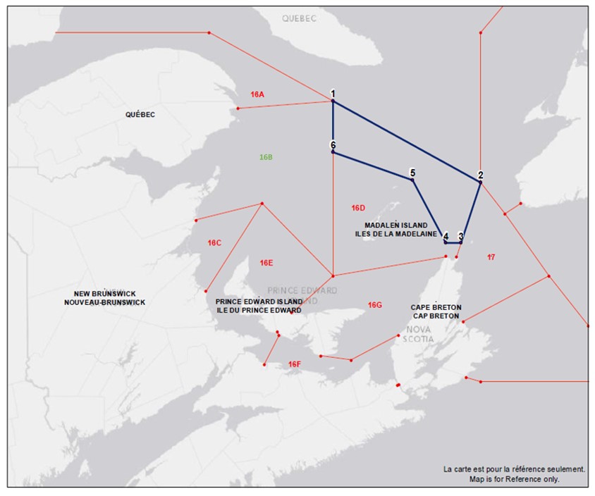
Description
Chart 4 is the map of the Area where the large purse seine fleet « Edge » fishery will occur which is defined as the waters enclosed rhumb lines (similar to straight lines plotted on a nautical chart) joining the following point s in the order they are listed:
Point 1 48°42’00” latitude North and 62°32’00” longitude West
Point 2 47°50’00” latitude North and 60°00’00” longitude West
Point 3 47°11’06” latitude North and 60°20’07” longitude West
Point 4 47°11’06” latitude North and 60°35’52” longitude West
Point 5 47°51’33” latitude North and 61°10’07” longitude West
Point 6 48°09’33” latitude North and 62°32’02” longitude West
Point 1 48°42’00” latitude North and 62°32’00” longitude West
Note: When the geographic boundary of an area is expressed in Latitude and Longitude, these point references are based on the geodesic system North American Datum 1927 (NAD27)
- Date modified: