
Conservation and Harvesting Plan for the southern Gulf of St. Lawrence bait Herring/Mackerel fishery
MONCTON – April 2, 2020 - Fisheries and Oceans Canada (DFO) announced today the Conservation and Harvesting Plan for the 2020 herring/mackerel bait fishery in the southern Gulf of St. Lawrence in Herring Fishing Areas 16A to G and 17.
2020 HERRING/MACKEREL BAIT FISHERY CONSERVATION HARVESTING PLAN
Bait licences are issued to fish harvesters who hold a licence for a species and gear that requires bait. Since 2003, herring and mackerel bait licences have been combined together in order to facilitate the enforcement of regulation by fishery officers.
NEW IN 2020
HAIL IN
Starting in 2020, a hail-in of catch estimate is now mandatory before entering port for fish harvesters from the Gulf Region. ALL herring/mackerel licence holders will need to enter in an agreement with a dockside monitoring company prior to commencing the fishery. As detailed in the conditions of licence, herring/mackerel bait licence holders will still be required to:
- MAINTAIN a Bait Fishery Monitoring Document (Gulf Region) or e-log (Quebec Region);
- HAIL-IN the catch estimates to a dockside monitoring company (Gulf Region); and
- SEND the report of these catches to their dockside monitoring company as indicated in the licence conditions.
GEAR MARKING
In December 2019, Fisheries and Oceans Canada announced the mandatory gear marking requirements for all non-tended fixed gear fisheries in Eastern Canada starting in 2020. Specific requirements are explained in the Notice to Fish Harvesters that was issued January 31, 2020 and details of these requirements are found in the herring/mackerel bait licence conditions.
FISHING AREA
Herring Fishing Area (HFA) 16A to 16G and 17.
GEAR ALLOWED
A maximum of 50 fathoms of gillnets with a minimum mesh size of 57.1 mm from April 1 until June 30 and 66.7 mm (63.5 mm in 16A) from July 1 to December 31 are authorized.
MAXIMUM DAILY QUANTITY ALLOWED
In 2020, the maximum quantity of herring or mackerel or the combination of both species a fish harvester is permitted to catch and retain at any time is 907 kg in total.
FISHING RESTRICTIONS
While fishing under the authority of a commercial herring, mackerel or gaspereau licence, bait licences are not valid. Furthermore, a fish harvester cannot fish under the authority of a bait licence in the same calendar day that they have landed herring, mackerel or gaspereau under the authority of a commercial licence. It is strictly forbidden to sell any species of fish caught under the authority of a bait licence.
REPORTING
BAIT FISHERY MONITORING DOCUMENT
All fish harvesters actively fishing with a herring/mackerel bait licence MUST REPORT their fishing activities whether there were fish caught or not.
Gulf Region fish harvesters: Must complete a Bait Fishery Monitoring Document before entering port.
Québec Region fish harvesters: The Elog must be completed for each fishing expedition and “closed” before arriving at port/landing. A fishing expedition means a voyage that commences at the time a fishing vessel leaves a port to engage in fishing and terminates at the time fish caught during that period are offloaded. Hence, when a fisher goes back to port for a reason other than for offloading fish and leaves port again, the fishing expedition goes on until fish are offloaded.
To consult the list of client applications approved by the Department and to obtain you Elog key, visit Fisheries and Ocean’s web page at the following address: http://www.dfo-mpo.gc.ca/elogs.
To request a modification to data that has been transmitted to Fisheries and Oceans Canada, you must communicate with the client support service at 1-877-535-7307.
LOST GEAR REPORTING
Licence holders must report any lost fishing gear to Fisheries and Oceans Canada (DFO) by completing and submitting the Lost Fishing Gear Form available online at http://www.dfo-mpo.gc.ca/fisheries-peches/commercial-commerciale/reporting-declaration-eng.html within 24 hours of entering to port after noticing the loss of gear. A Lost Fishing Gear Form is also included in the herring/mackerel bait licence conditions.
RETRIEVED GEAR REPORTING
Licence holders must report the retrieval of any of their own previously reported lost gear to DFO by completing and submitting the Retrieval of Previously Reported Fishing Gear Form available online at http://www.dfo-mpo.gc.ca/fisheries-peches/commercial-commerciale/reporting-declaration-eng.html within 24 hours of entering to port after retrieving gear previously reported as lost. Retrieval can only occur during the validity period of these licence conditions and only in relation to the specific type of gear authorized to be used by these licence conditions. A Retrieval of Previously Reported Fishing Gear Form is also included in the herring/mackerel bait licence conditions.
CLOSED SPAWNING GROUNDS
The spawning grounds in HFA 16B, 16E, 16C and 16D defined in the following charts 1 to 4 are closed from April 1 until June 30.
CHART 1
Closure of the commercial spring fishery in a portion of HFA 16E near Cape Egmont
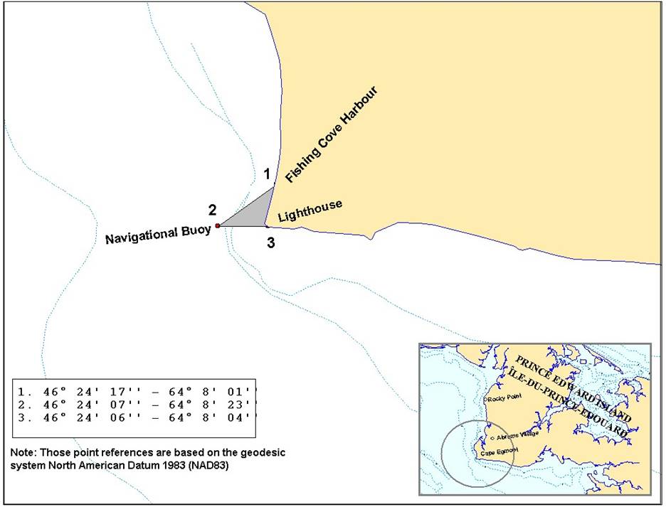
Description
The closure of the spawning ground near Cape Egmont on Prince Edward Island in Herring Fishing Area 16E is defined as the waters enclosed by the coastlines and rhumb lines (similar to straight lines plotted on a nautical chart) joining the following point s in the order they are listed:
Point 1 46°24’17’’ latitude North et 64°08’01’’ longitude West
Point 2 46°24’07’’ latitude North et 64°08’23’’ longitude West
Point 3 46°24’06’’ latitude North et 64°08’04’’ longitude West
Note: These reference points are based on the geodesic system North American Datum 1983 (NAD83)
CHART 2
Exclusion zone in the Grande-Entrée Channel in HFA 16D
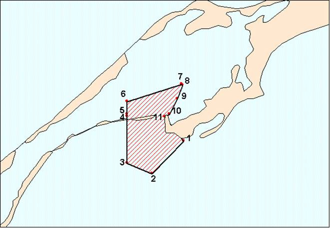
Description
The closure of the exclusion zone in the Grande-Entrée channel in the Magdalen Islands in Herring Fishing Area 16D is defined as the waters enclosed by the coastlines and rhumb lines (similar to straight lines plotted on a nautical chart) joining the following points in the order they are listed:
Point 1 47° 32' 30'' longitude North et 61° 32' 39'' latitude West
Point 2 47° 31' 16'' longitude North et 61° 34' 26'' latitude West
Point 3 47° 31' 40'' longitude North et 61° 35' 48'' latitude West
Point 4 47° 33' 26'' longitude North et 61° 35' 48'' latitude West
Point 5 47° 33' 31'' longitude North et 61° 35' 48'' latitude West
Point 6 47° 34' 00'' longitude North et 61° 35' 48'' latitude West
Point 7 47° 34' 39'' longitude North et 61° 32' 46'' latitude West
Point 8 47° 34' 37'' longitude North et 61° 32' 43'' latitude West
Point 9 47° 34' 06'' longitude North et 61° 33' 00'' latitude West
Point 10 47° 33' 31'' longitude North et 61° 33' 27'' latitude West
Point 11 47° 33' 25'' longitude North et 61° 33' 43'' latitude West
Exclusion zone in the Havre Aubert harbour in HFA 16D
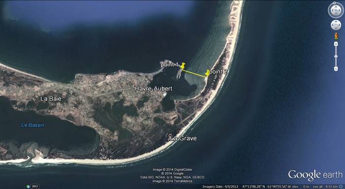
Description
The closure of the exclusion zone in the Grande-Entrée channel in the Magdalen Islands in Herring Fishing Area 16D is defined as the waters enclosed by the coastlines and rhumb lines (similar to straight lines plotted on a nautical chart) joining the following points in the order they are listed:
Point 1 47° 14' 09.20'' longitude North et 61° 49' 40.10'' latitude West
Point 2 47° 13' 57.30'' longitude North et 61° 49' 09.90'' latitude West
Note: These reference points are based on the geodesic system North American Datum 1983 (NAD83)
Note: These reference points are based on the geodesic system North American Datum 1983 (NAD83)
CHART 3
Closure of the spring commercial fishery on spawning beds in New Mills, Carleton and St-Omer in HFA 16B (Grey zones)
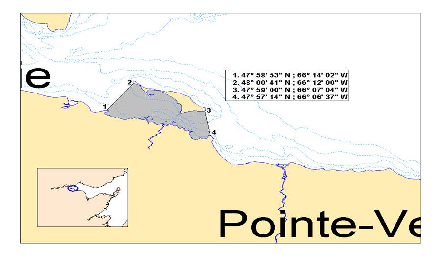
Description
The closure of spawning beds near New Mills in New Brunswick in Herring Fishing Area 16B is defined as the waters enclosed by the coastlines and rhumb lines (similar to straight lines plotted on a nautical chart) joining the following point s in the order they are listed:
Point 1 47°58’53’’ longitude North et 66°14’ 2’’ latitude West
Point 2 48°00’41’’ longitude North et 66°12’00’’ latitude West
Point 3 47°59’00’’ longitude North et 66°07’04’’ latitude West
Point 4 47°57’14’’ longitude North et 66°06’34’’ latitude West
Note: These reference points are based on the geodesic system North American Datum 1983 (NAD83)
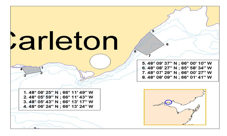
Description
The closure of the spawning beds near Carleton on the Gaspesian Peninsula in Herring Fishing Area 16B is defined as the waters enclosed by the coastlines and rhumb lines (similar to straight lines plotted on a nautical chart) joining the following point s in the order they are listed:
Point 1 48°06’25’’ longitude North et 66°11’49’’ latitude West
Point 2 48°05’59’’ longitude North et 66°11’43’’ latitude West
Point 3 48°05’43’’ longitude North et 66°13’14’’ latitude West
Point 4 48°06’24’’ longitude North et 66°13’24’’ latitude West
The closure of the spawning beds near St. Omer on the Gaspesian Peninsula in Herring Fishing Area 16B is defined as the waters enclosed by the coastlines and rhumb lines (similar to straight lines plotted on a nautical chart) joining the following point s in the order they are listed:
Point 1 48°09’37’’ longitude North et 66°00’10’’ latitude West
Point 2 48°08’27’’ longitude North et 66°58’34’’ latitude West
Point 3 48°07’29’’ longitude North et 66°00’27’’ latitude West
Point 4 48°08’09’’ longitude North et 66°01’41’’ latitude West
Note: These reference points are based on the geodesic system North American Datum 1983 (NAD83)
Note: These reference points are based on the geodesic system North American Datum 1983 (NAD83)
CHART 4
Closure of the spring commercial fishery on a spawning bed near Point Escuminac (N.B.) in HFA 16C (Grey zone)
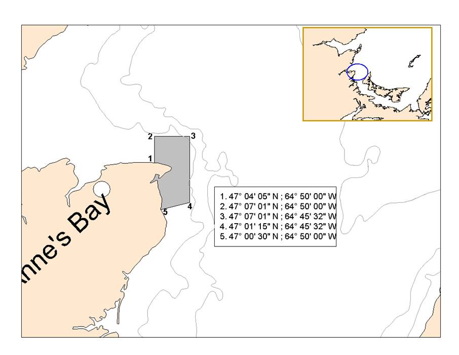
Description
The closure of the spawning bed near Point Escuminac in New Brunswick in Herring Fishing Area 16C is defined as the waters enclosed by the coastlines and rhumb lines (similar to straight lines plotted on a nautical chart) joining the following point s in the order they are listed:
Point 1 47°04’05’’ longitude North et 64°50’00’’ latitude West
Point 2 47°07’01’’ longitude North et 64°50’00’’ latitude West
Point 3 47°07’01’’ longitude North et 64°45’32’’ latitude West
Point 4 47°01’15’’ longitude North et 64°45’32’’ latitude West
Point 5 47°00’30’’ longitude North et 64°50’00’’ latitude West
Note: These reference points are based on the geodesic system North American Datum 1983 (NAD83)
Note: These reference points are based on the geodesic system North American Datum 1983 (NAD83)
CHART 5
Closure of the spring commercial fishery on a spawning bed near Cape Jourimain (N.B.) in HFA 16E (Grey zone)
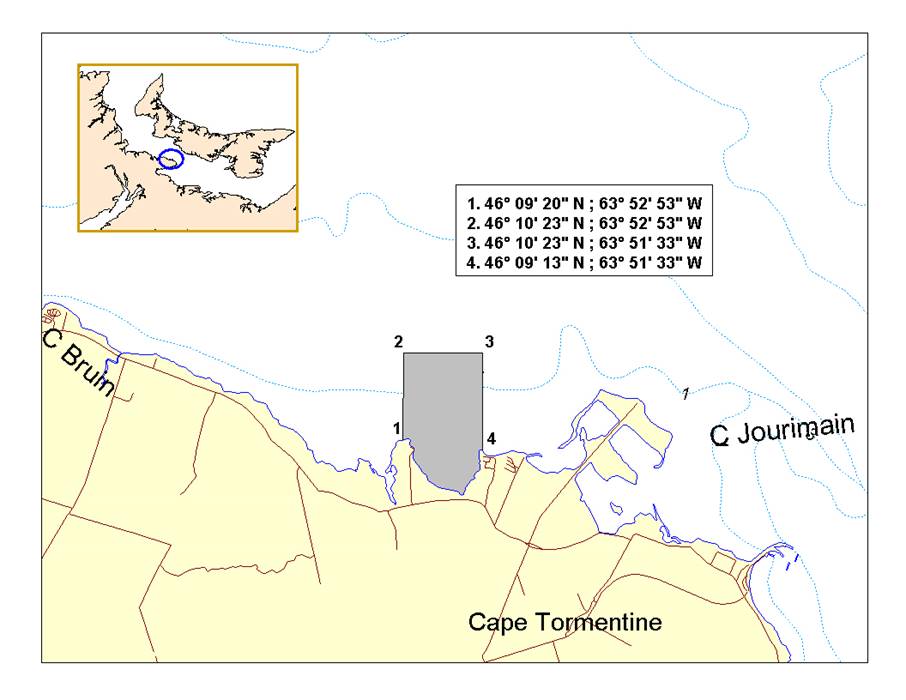
Description
The closure of the spawning bed near Cape Jourimain in New Brunswick in Herring Fishing Area 16E is defined as the waters enclosed by the coastlines and rhumb lines (similar to straight lines plotted on a nautical chart) joining the following point s in the order they are listed:
Point 1 46°09’20’’ longitude North et 63°52’53’’ latitude West
Point 2 46°10’23’’ longitude North et 63°52’53’’ latitude West
Point 3 46°10’23’’ longitude North et 63°51’33’’ latitude West
Point 4 46°09’13’’ longitude North et 63°51’33’’ latitude West
Note: These reference points are based on the geodesic system North American Datum 1983 (NAD83)
Note: These reference points are based on the geodesic system North American Datum 1983 (NAD83)
FOR MORE INFORMATION:
Ben Moore
Resource Management
Fisheries and Oceans Canada
Charlottetown, PE
(902) 370-7094
Sandra Comeau
Resource Management
Fisheries and Oceans Canada
Tracadie, NB
(506) 395-7765
Alan Dwyer
Resource Management
Fisheries and Oceans Canada
Antigonish, NS
(902) 735-7114
Caroline Leclerc
Resource Management
Fisheries and Oceans
Gaspé, QC
(418) 368-5559
Josée Richard
Resource Management
Fisheries and Oceans
Cap-aux-Meules, QC
(418) 986-2095
Mario Gaudet
Resource Management
Fisheries and Oceans Canada
Moncton, NB
(506) 871-0648
- Date modified: